Brookfield, Georgia
Submit your own pictures of this place and show them to the world
- OSM Map
- General Map
- Google Map
- MSN Map

| Males: 2,274 | |
| Females: 2,267 |
| Median resident age: | 37.4 years |
| Georgia median age: | 33.4 years |
Zip code: 31794
| Brookfield: | $69,843 |
| GA: | $72,837 |
Estimated per capita income in 2022: $33,461 (it was $19,841 in 2000)
Brookfield CCD income, earnings, and wages data
Estimated median house or condo value in 2022: $200,600 (it was $79,100 in 2000)
| Brookfield: | $200,600 |
| GA: | $297,400 |
Mean prices in 2022: all housing units: $178,542; detached houses: $213,083; townhouses or other attached units: $264,074; in 5-or-more-unit structures: $644,727; mobile homes: $60,344; occupied boats, rvs, vans, etc.: $63,671
Detailed information about poverty and poor residents in Brookfield, GA
Compare current foreclosures near Brookfield, GA:
| Photo | Address | Area | Beds / Baths | Price | Details |
|---|---|---|---|---|---|

|
#1
N Broad St
Lenox, GA 31637
|
980 sq. feet
|
1 baths - beds |
$29,900
|
show details |

|
#2
Crescent Dr
Tifton, GA 31794
|
2,133 sq. feet
|
3 baths 4 beds |
show details | |

|
#3
Church St
Enigma, GA 31749
|
804 sq. feet
|
2 baths 2 beds |
show details | |

|
#4
Deer Run Rd
Tifton, GA 31794
|
1,344 sq. feet
|
2 baths 3 beds |
show details | |

|
#5
Ed Lindsey Rd
Lenox, GA 31637
|
- sq. feet
|
2 baths 4 beds |
show details | |

|
#6
48th St
Tifton, GA 31794
|
2,000 sq. feet
|
2 baths 3 beds |
show details | |

|
#7
Hall Whitley Rd
Lenox, GA 31637
|
1,440 sq. feet
|
2 baths 3 beds |
show details | |

|
#8
Whiddon Mill Rd
Tifton, GA 31793
|
1,379 sq. feet
|
2 baths 3 beds |
show details | |

|
#9
40th St E
Tifton, GA 31794
|
4,012 sq. feet
|
3 baths 4 beds |
show details | |

|
#10
Ty Ty Sparks Rd
Ty Ty, GA 31795
|
2,400 sq. feet
|
2 baths 3 beds |
show details |
| Photo | Address | Area | Beds / Baths | Price | Details |
|---|---|---|---|---|---|

|
#11
Hillcrest Dr
Tifton, GA 31794
|
1,216 sq. feet
|
1 baths 2 beds |
show details | |

|
#12
E Washington St
Tifton, GA 31794
|
1,203 sq. feet
|
1 baths 3 beds |
show details | |

|
#13
42nd St E
Tifton, GA 31794
|
1,640 sq. feet
|
2 baths 3 beds |
show details | |

|
#14
Spurlock Rd
Alapaha, GA 31622
|
952 sq. feet
|
2 baths 3 beds |
show details | |

|
#15
Holland Rd
Tifton, GA 31794
|
2,262 sq. feet
|
2 baths 3 beds |
show details | |

|
#16
Chula Brookfield Rd
Chula, GA 31733
|
2,176 sq. feet
|
2 baths 3 beds |
show details | |

|
#17
Brookhaven Dr
Tifton, GA 31794
|
1,033 sq. feet
|
1 baths 3 beds |
show details | |

|
#18
Russell Rd
Fitzgerald, GA 31750
|
1,935 sq. feet
|
2 baths 3 beds |
show details | |

|
#19
Chapel Hill Cir
Enigma, GA 31749
|
2,128 sq. feet
|
2 baths 3 beds |
show details | |

|
#20
Hillside Ln
Fitzgerald, GA 31750
|
1,404 sq. feet
|
2 baths 3 beds |
show details |
| Photo | Address | Area | Beds / Baths | Price | Details |
|---|---|---|---|---|---|

|
#21
Barnes Chapel Rd
Enigma, GA 31749
|
1,344 sq. feet
|
2 baths 3 beds |
show details | |

|
#22
15th St W
Tifton, GA 31794
|
1,619 sq. feet
|
1 baths - beds |
show details | |

|
#23
Midland Ave
Tifton, GA 31794
|
- sq. feet
|
2 baths 3 beds |
show details | |

|
#24
Carolina Dr
Tifton, GA 31794
|
1,639 sq. feet
|
2 baths - beds |
show details | |

|
#25
Midland Ave
Tifton, GA 31794
|
- sq. feet
|
2 baths 4 beds |
show details | |

|
#26
College Ave S
Tifton, GA 31794
|
1,923 sq. feet
|
2 baths - beds |
show details | |

|
#27
Lewis St
Tifton, GA 31794
|
1,782 sq. feet
|
2 baths - beds |
show details | |

|
#28
Fulwood Blvd
Tifton, GA 31794
|
1,842 sq. feet
|
2 baths - beds |
show details | |

|
#29
Clyde Cir
Tifton, GA 31794
|
1,560 sq. feet
|
2 baths - beds |
show details | |

|
#30
Florida Dr
Tifton, GA 31794
|
1,602 sq. feet
|
2 baths - beds |
show details |
| Photo | Address | Area | Beds / Baths | Price | Details |
|---|---|---|---|---|---|

|
#31
King Dr
Tifton, GA 31794
|
1,014 sq. feet
|
1 baths - beds |
show details | |

|
#32
College Ave S
Tifton, GA 31794
|
1,404 sq. feet
|
1 baths - beds |
show details | |

|
#33
Pehler Dr
Tifton, GA 31794
|
1,033 sq. feet
|
1 baths - beds |
show details | |

|
#34
Emerson O Bynes Ave
Tifton, GA 31794
|
1,198 sq. feet
|
2 baths - beds |
show details | |

|
#35
Connecticut Dr
Tifton, GA 31794
|
2,237 sq. feet
|
2 baths - beds |
show details | |

|
#36
Mcclellan Dr
Tifton, GA 31794
|
2,434 sq. feet
|
2 baths - beds |
show details | |

|
#37
5th Ave
Tifton, GA 31794
|
1,032 sq. feet
|
1 baths - beds |
show details | |

|
#38
Brighton Rd
Tifton, GA 31794
|
2,664 sq. feet
|
2 baths - beds |
show details | |

|
#39
Shady Ln
Tifton, GA 31794
|
988 sq. feet
|
1 baths - beds |
show details | |

|
#40
Davis Ave
Tifton, GA 31794
|
1,200 sq. feet
|
1 baths - beds |
show details |
| Photo | Address | Area | Beds / Baths | Price | Details |
|---|---|---|---|---|---|

|
#41
18th St W
Tifton, GA 31794
|
1,303 sq. feet
|
3 baths - beds |
show details | |

|
#42
Park Ave N
Tifton, GA 31794
|
1,068 sq. feet
|
2 baths - beds |
show details | |

|
#43
Wilson Ave N
Tifton, GA 31794
|
1,314 sq. feet
|
2 baths - beds |
show details | |

|
#44
20th St E
Tifton, GA 31794
|
1,642 sq. feet
|
1 baths - beds |
show details | |

|
#45
Clyde Ln
Tifton, GA 31794
|
768 sq. feet
|
1 baths - beds |
show details | |

|
#46
Solomon Nixon Pl
Tifton, GA 31794
|
1,394 sq. feet
|
2 baths - beds |
show details | |

|
#47
Tiffany Dr
Tifton, GA 31794
|
1,512 sq. feet
|
1 baths - beds |
show details | |

|
#48
1/2 Hill Ave
Tifton, GA 31794
|
784 sq. feet
|
1 baths - beds |
show details | |

|
#49
11th St W
Tifton, GA 31794
|
1,460 sq. feet
|
2 baths - beds |
show details | |

|
Check over 1 million property listings on Foreclosure.com!
|
browse all offers | |||

- 3,79891.7%White alone
- 2145.2%Black alone
- 711.7%Hispanic
- 390.9%Asian alone
- 110.3%Two or more races
- 50.1%American Indian alone
- 20.05%Native Hawaiian and Other
Pacific Islander alone - 20.05%Other race alone

Races in Brookfield detailed stats: ancestries, foreign born residents, place of birth
 Recent articles from our blog. Our writers, many of them Ph.D. graduates or candidates, create easy-to-read articles on a wide variety of topics.
Current Local Time: EST time zone
Elevation: 328 feet
Land area: 57.5 square miles.
Population density: 79 people per square mile (very low).

| Brookfield CCD: | 0.9% ($722) |
| Georgia: | 0.9% ($919) |
Nearest city with pop. 50,000+: Albany, GA  (44.7 miles , pop. 76,939).
Nearest city with pop. 200,000+: Jacksonville, FL (131.5 miles , pop. 735,617).
Nearest city with pop. 1,000,000+: Houston, TX (721.6 miles , pop. 1,953,631).
Nearest cities:
), ), ), ), ), Latitude: 31.48 N, Longitude: 83.42 W
Area code commonly used in this area: 229


| Here: | 2.5% |
| Georgia: | 2.9% |

- Educational services (10.2%)
- Health care (9.4%)
- Public administration (5.1%)
- Construction (4.7%)
- Agriculture, forestry, fishing & hunting (4.5%)
- Metal & metal products (4.4%)
- Accommodation & food services (3.7%)

- Construction (8.2%)
- Agriculture, forestry, fishing & hunting (6.2%)
- Metal & metal products (5.2%)
- Truck transportation (5.1%)
- Educational services (5.1%)
- Public administration (4.9%)
- Motor vehicle & parts dealers (4.4%)

- Educational services (17.2%)
- Health care (16.3%)
- Public administration (5.5%)
- Accommodation & food services (4.8%)
- Personal & laundry services (4.1%)
- Real estate & rental & leasing (3.9%)
- Finance & insurance (3.7%)

- Other sales and related occupations, including supervisors (5.7%)
- Driver/sales workers and truck drivers (5.7%)
- Preschool, kindergarten, elementary, and middle school teachers (4.3%)
- Electrical equipment mechanics and other installation, maintenance, and repair workers, including supervisors (4.2%)
- Other production occupations, including supervisors (4.2%)
- Other office and administrative support workers, including supervisors (4.1%)
- Top executives (4.0%)

- Driver/sales workers and truck drivers (8.8%)
- Electrical equipment mechanics and other installation, maintenance, and repair workers, including supervisors (7.4%)
- Other sales and related occupations, including supervisors (7.3%)
- Other production occupations, including supervisors (6.7%)
- Top executives (6.2%)
- Other management occupations, except farmers and farm managers (5.7%)
- Building and grounds cleaning and maintenance occupations (4.2%)

- Preschool, kindergarten, elementary, and middle school teachers (8.5%)
- Other office and administrative support workers, including supervisors (7.8%)
- Secretaries and administrative assistants (5.0%)
- Financial clerks, except bookkeeping, accounting and auditing clerks (4.1%)
- Assemblers and fabricators (4.1%)
- Cashiers (3.9%)
- Registered nurses (3.7%)
Average climate in Brookfield, Georgia
Based on data reported by over 4,000 weather stations


Tornado activity:
Brookfield-area historical tornado activity is near Georgia state average. It is 28% greater than the overall U.S. average.
On 5/11/1952, a category F3 (max. wind speeds 158-206 mph) tornado 12.4 miles away from the Brookfield place center injured 10 people and caused between $500,000 and $5,000,000 in damages.
On 11/11/1968, a category F3 tornado 31.5 miles away from the place center caused between $5000 and $50,000 in damages.
Earthquake activity:
Brookfield-area historical earthquake activity is significantly above Georgia state average. It is 25% smaller than the overall U.S. average.On 8/2/1974 at 08:52:09, a magnitude 4.9 (4.3 MB, 4.9 LG, Class: Light, Intensity: IV - V) earthquake occurred 174.3 miles away from Brookfield center
On 10/24/1997 at 08:35:17, a magnitude 4.9 (4.8 MB, 4.2 MS, 4.9 LG, Depth: 6.2 mi) earthquake occurred 229.1 miles away from the city center
On 4/29/2003 at 08:59:39, a magnitude 4.9 (4.4 MB, 4.6 MW, 4.9 LG) earthquake occurred 244.9 miles away from the city center
On 11/22/1974 at 05:25:55, a magnitude 4.7 (4.7 MB) earthquake occurred 215.4 miles away from the city center
On 1/18/1999 at 07:00:53, a magnitude 4.8 (4.8 MB, 4.0 LG, Depth: 0.6 mi) earthquake occurred 260.6 miles away from Brookfield center
On 4/29/2003 at 08:59:39, a magnitude 4.6 (4.6 MW, Depth: 12.3 mi) earthquake occurred 244.9 miles away from the city center
Magnitude types: regional Lg-wave magnitude (LG), body-wave magnitude (MB), surface-wave magnitude (MS), moment magnitude (MW)
Natural disasters:
The number of natural disasters in Tift County (11) is smaller than the US average (15).Major Disasters (Presidential) Declared: 7
Emergencies Declared: 3
Causes of natural disasters: Tornadoes: 5, Floods: 3, Hurricanes: 2, Storms: 2, Winds: 2, Drought: 1, Heavy Rain: 1, Snowfall: 1, Tropical Storm: 1, Winter Storm: 1, Other: 1 (Note: some incidents may be assigned to more than one category).
Hospitals and medical centers near Brookfield:
- AMEDISYS HOME HEALTH (Home Health Center, about 4 miles away; TIFTON, GA)
- GOLDEN LIVINGCENTER - TIFTON (Nursing Home, about 5 miles away; TIFTON, GA)
- TIFTON NH (Nursing Home, about 5 miles away; TIFTON, GA)
- HOSPICE OF TIFT AREA (Hospital, about 5 miles away; TIFTON, GA)
- TIFT HEALTH CARE, INC (Nursing Home, about 6 miles away; TIFTON, GA)
- TIFT REGIONAL MEDICAL CENTER Acute Care Hospitals (about 6 miles away; TIFTON, GA)
- TRANSITIONAL CARE CENTER (Nursing Home, about 6 miles away; TIFTON, GA)
Colleges/universities with over 2000 students nearest to Brookfield:
- Abraham Baldwin Agricultural College (about 7 miles; Tifton, GA; Full-time enrollment: 2,564)
- South Georgia State College (about 34 miles; Douglas, GA; FT enrollment: 2,507)
- Wiregrass Georgia Technical College (about 41 miles; Valdosta, GA; FT enrollment: 3,246)
- Albany State University (about 44 miles; Albany, GA; FT enrollment: 3,662)
- Valdosta State University (about 45 miles; Valdosta, GA; FT enrollment: 11,155)
- Albany Technical College (about 45 miles; Albany, GA; FT enrollment: 3,707)
- Darton State College (about 48 miles; Albany, GA; FT enrollment: 5,000)
Points of interest:
Notable locations in Brookfield: Tift County Fire Department Station 6 (A), Tift County Fire Department Station 8 (B). Display/hide their locations on the map
Churches in Brookfield include: Vanceville Church (A), Corinth Church (B), Brighton Church (C), Brookfield Baptist Church (D), Brookfield Methodist Church (E), Liberty Church (F), First Defiance Church (G), Mount Olive Church (H), New River Church (I). Display/hide their locations on the map
Cemeteries: Harding Cemetery (1), Lawrence Cemetery (2), Tift Memorial Gardens (3). Display/hide their locations on the map
Lakes and reservoirs: Moss Lake (A), Mudcat Lake (B), Big Mud Lake (C), Gun Lake (D), Graveyard Lake (E), Goodman Lake (F), Ferry Lake (G), Bakers Pond (H). Display/hide their locations on the map
Creeks: Thick Creek (A), Gum Creek (B), Little Creek (C). Display/hide their locations on the map
| This place: | 2.7 people |
| Georgia: | 2.6 people |
| This place: | 79.9% |
| Whole state: | 68.5% |
| This place: | 4.0% |
| Whole state: | 5.9% |
Likely homosexual households (counted as self-reported same-sex unmarried-partner households)
- Lesbian couples: 0.2% of all households
- Gay men: 0.2% of all households
| This place: | 7.1% |
| Whole state: | 13.0% |
| This place: | 2.3% |
| Whole state: | 6.1% |
For population 15 years and over in Brookfield:

- Never married: 17.0%
- Now married: 69.9%
- Separated: 1.4%
- Widowed: 5.8%
- Divorced: 7.3%
For population 25 years and over in Brookfield:
- High school or higher: 69.2%
- Bachelor's degree or higher: 18.7%
- Graduate or professional degree: 7.9%
- Unemployed: 3.0%
- Mean travel time to work (commute): 18.9 minutes


| Here: | 14.3 |
| Georgia average: | 13.3 |
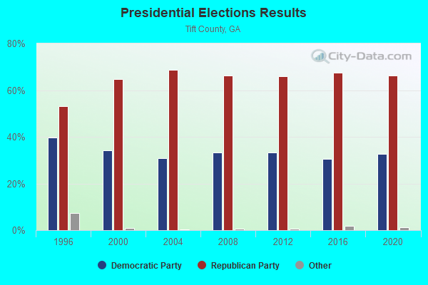
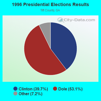


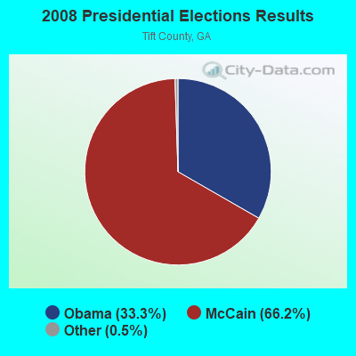

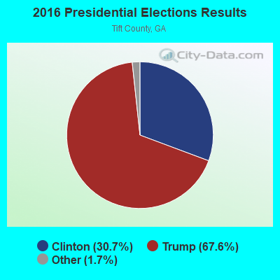

Graphs represent county-level data. Detailed 2008 Election Results
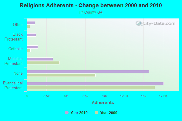
Religion statistics for Brookfield, GA (based on Tift County data)
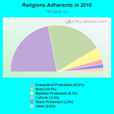
| Religion | Adherents | Congregations |
|---|---|---|
| Evangelical Protestant | 17,601 | 57 |
| Mainline Protestant | 3,324 | 11 |
| Catholic | 1,374 | 1 |
| Black Protestant | 1,130 | 5 |
| Other | 1,030 | 3 |
| None | 15,659 | - |
Food Environment Statistics:
| This county: | 2.14 / 10,000 pop. |
| State: | 1.91 / 10,000 pop. |
| Tift County: | 0.24 / 10,000 pop. |
| Georgia: | 0.15 / 10,000 pop. |
| Tift County: | 1.91 / 10,000 pop. |
| Georgia: | 0.86 / 10,000 pop. |
| This county: | 10.24 / 10,000 pop. |
| Georgia: | 5.12 / 10,000 pop. |
| Tift County: | 7.86 / 10,000 pop. |
| State: | 7.41 / 10,000 pop. |
| Tift County: | 11.6% |
| Georgia: | 10.4% |
| Tift County: | 32.0% |
| Georgia: | 27.8% |
| Here: | 17.5% |
| State: | 14.6% |
Strongest AM radio stations in Brookfield:
- WTIF (1340 AM; 1 kW; TIFTON, GA; Owner: TIFTON BROADCASTING CORP.)
- WMGA (1130 AM; 10 kW; MOULTRIE, GA; Owner: RADIO MOULTRIE, INC.)
- WSTT (730 AM; 25 kW; THOMASVILLE, GA; Owner: MARION R. WILLIAMS)
- WFVR (910 AM; 50 kW; VALDOSTA, GA; Owner: RAMA COMMUNICATIONS, INC.)
- WMAC (940 AM; 50 kW; MACON, GA; Owner: CUMULUS LICENSING CORP.)
- WOKV (690 AM; 50 kW; JACKSONVILLE, FL; Owner: COX RADIO, INC.)
- WMTM (1300 AM; 5 kW; MOULTRIE, GA; Owner: COLQUITT BROADCASTING COMPANY, LLC)
- WDMG (860 AM; 5 kW; DOUGLAS, GA; Owner: RTG RADIO, LLC)
- WHGH (840 AM; daytime; 10 kW; THOMASVILLE, GA; Owner: H. G. H INVESTMENT CORP.)
- WJEP (1020 AM; daytime; 10 kW; OCHLOCKNEE, GA; Owner: LIFELINE MINISTRIES, INCORPORATED)
- WOKA (1310 AM; 4 kW; DOUGLAS, GA; Owner: COFFEE COUNTY BROADCASTERS, INC.)
- WKTF (1550 AM; 10 kW; VIENNA, GA; Owner: SANTILLANA BROADCASTING, INC.)
- WGST (640 AM; 50 kW; ATLANTA, GA; Owner: CITICASTERS LICENSES, L.P.)
Strongest FM radio stations in Brookfield:
- WKAA (97.7 FM; OCILLA, GA; Owner: RTG RADIO, LLC)
- WKZZ (92.5 FM; TIFTON, GA; Owner: RTG RADIO, LLC)
- WLPF (98.5 FM; OCILLA, GA; Owner: BARINOWSKI INVESTMENT COMPANY)
- WABR (91.1 FM; TIFTON, GA; Owner: GEORGIA PUBLIC TELECOMM, COMMISSION)
- WTIF-FM (107.5 FM; OMEGA, GA; Owner: OMEGA BROADCASTING CORP)
- WOBB (100.3 FM; TIFTON, GA; Owner: CLEAR CHANNEL BROADCASTING LICENSES, INC.)
- WDMG-FM (99.5 FM; DOUGLAS, GA; Owner: RTG RADIO, LLC)
- WJYF (95.3 FM; NASHVILLE, GA; Owner: TIFTON BROADCASTING CORP.)
- WOKA-FM (106.7 FM; DOUGLAS, GA; Owner: COFFEE COUNTY BROADCASTERS, INC.)
- WAEF (90.3 FM; CORDELE, GA; Owner: AMERICAN FAMILY ASSOCIATION)
- WBJY (89.3 FM; AMERICUS, GA; Owner: AMERICAN FAMILY ASSOCIATION)
- WMTM-FM (93.9 FM; MOULTRIE, GA; Owner: COLQUITT BROADCASTING COMPANY, LLC)
- WDDQ (92.1 FM; ADEL, GA; Owner: WILLIAMS INVESTMENT COMPANY)
- WRDO (96.9 FM; FITZGERALD, GA; Owner: RTG RADIO, LLC)
- WFFM (105.7 FM; ASHBURN, GA; Owner: ON TOP COMMUNICATIONS OF GEORGIA, LLC)
- WZBN (102.1 FM; SYLVESTER, GA; Owner: CUMULUS LICENSING CORP.)
- WPLH (103.1 FM; TIFTON, GA; Owner: ABRAHAM BALDWIN AGRICULTURAL COLLEGE)
TV broadcast stations around Brookfield:
- W33BX (Channel 33; TIFTON, GA; Owner: TRINITY BROADCASTING NETWORK)
- W12DA (Channel 12; TIFTON, GA; Owner: TIFT AREA TV, INC.)
- WVAG (Channel 44; VALDOSTA, GA; Owner: HUTCHENS COMMUNICATIONS, INC.)
- W51AR (Channel 51; TIFTON, GA; Owner: NORTHSIDE BAPTIST CHURCH)
- WALB (Channel 10; ALBANY, GA; Owner: LIBCO, INC.)
- WFXL (Channel 31; ALBANY, GA; Owner: WAITT LICENSE COMPANY OF GEORGIA, L.L.C.)
- WABW-TV (Channel 14; PELHAM, GA; Owner: GEORGIA PUBLIC TELECOMMUNICATIONS COMMISSION)
FCC Registered Antenna Towers:
2- Edward G Roach, 2443 Highway 82 East (Ga21242-A) (Lat: 31.421583 Lon: -83.393278), Type: 60.7, Structure height: 13277 m, Overall height: 59.4 m, Registrant: Sba Structures, LLC, Eroach@sbasite.Com, , Boca -Raton, Phone: (561) 995-7670
- Edward G Roach, 2443 Highway 82 East (Ga21242-A) (Lat: 31.421583 Lon: -83.393278), Type: 60.7, Structure height: 13277 m, Overall height: 59.4 m, Licensee ID: L, Registrant: Sba Structures, LLC, Eroach@sbasite.Com, , Boca -Raton, Phone: (561) 995-7670

- 69.6%Electricity
- 23.1%Bottled, tank, or LP gas
- 2.9%No fuel used
- 1.8%Fuel oil, kerosene, etc.
- 1.5%Wood
- 1.2%Utility gas

- 55.2%Bottled, tank, or LP gas
- 40.8%Electricity
- 2.3%Utility gas
- 1.7%No fuel used
Brookfield compared to Georgia state average:
- Unemployed percentage significantly below state average.
- Black race population percentage significantly below state average.
- Hispanic race population percentage significantly below state average.
- Foreign-born population percentage significantly below state average.
- Renting percentage below state average.
- Length of stay since moving in significantly above state average.
- Number of rooms per house significantly below state average.
- House age significantly below state average.