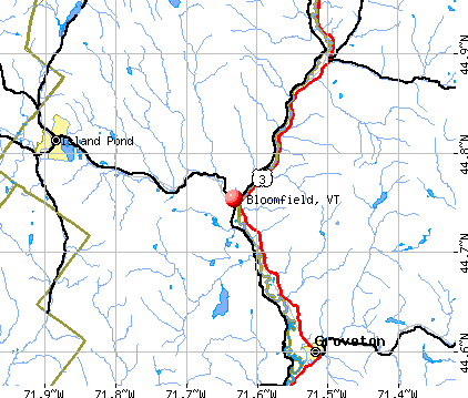
Bloomfield, Vermont
Submit your own pictures of this town and show them to the world
- OSM Map
- General Map
- Google Map
- MSN Map
Population change since 2000: -15.3%
 |
| Males: 118 | |
| Females: 103 |
| Median resident age: | 50.1 years |
| Vermont median age: | 45.8 years |
Zip codes: 05905.
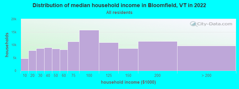
| Bloomfield: | $60,682 |
| VT: | $73,991 |
Estimated per capita income in 2022: $38,700 (it was $17,224 in 2000)
Bloomfield town income, earnings, and wages data
Estimated median house or condo value in 2022: $168,889 (it was $70,600 in 2000)
| Bloomfield: | $168,889 |
| VT: | $304,700 |
Detailed information about poverty and poor residents in Bloomfield, VT


- 21898.6%White alone
- 20.9%Two or more races
- 10.5%Black alone

Races in Bloomfield detailed stats: ancestries, foreign born residents, place of birth
According to our research of Vermont and other state lists, there was 1 registered sex offender living in Bloomfield, Vermont as of May 26, 2024.
The ratio of all residents to sex offenders in Bloomfield is 221 to 1.
 Recent articles from our blog. Our writers, many of them Ph.D. graduates or candidates, create easy-to-read articles on a wide variety of topics.

 | We are ready, really ready - for Vermont. (30 replies) |
| Need Help Planning A 7 State New England Fall Foliage Tour (39 replies) |
| Vermont Weather (3779 replies) |
| Deciding on if I should move to Vermont... (11 replies) |
| Vermont vs. New Hampshire vs. Maine (X-post) (19 replies) |
| How do you know, no matter where you are, that you are a Vermonter? (14 replies) |
Latest news from Bloomfield, VT collected exclusively by city-data.com from local newspapers, TV, and radio stations
Ancestries: French (57.5%), English (36.0%), Irish (18.8%), French Canadian (10.3%), German (3.4%), United States (2.3%).
Current Local Time: EST time zone
Elevation: 912 feet
Land area: 40.4 square miles.
Population density: 5.5 people per square mile (very low).
11 residents are foreign born (4.2% North America).
| This town: | 4.2% |
| Vermont: | 3.8% |
| Bloomfield town: | 1.1% ($765) |
| Vermont: | 2.0% ($2,196) |
Nearest city with pop. 50,000+: Portland, ME  (103.4 miles , pop. 64,249).
Nearest city with pop. 200,000+: Boston, MA (173.3 miles , pop. 589,141).
Nearest city with pop. 1,000,000+: Bronx, NY (295.8 miles , pop. 1,332,650).
Nearest cities:
), ), )Latitude: 44.80 N, Longitude: 71.64 W
Area code: 802

| Here: | 5.8% |
| Vermont: | 2.0% |


- Furniture & related product manufacturing (21.0%)
- Paper (8.8%)
- Educational services (8.8%)
- Construction (6.1%)
- Agriculture, forestry, fishing & hunting (5.5%)
- Accommodation & food services (5.5%)
- Metal & metal products (4.4%)

- Furniture & related product manufacturing (25.3%)
- Construction (11.1%)
- Paper (9.1%)
- Agriculture, forestry, fishing & hunting (7.1%)
- Accommodation & food services (7.1%)
- Sporting goods, camera, hobby & toy stores (4.0%)
- Public administration (4.0%)

- Furniture & related product manufacturing (15.9%)
- Educational services (15.9%)
- Paper (8.5%)
- Plastics & rubber products (7.3%)
- Finance & insurance (7.3%)
- Metal & metal products (6.1%)
- Department & other general merchandise stores (4.9%)

- Other production occupations, including supervisors (12.2%)
- Laborers and material movers, hand (9.4%)
- Other sales and related occupations, including supervisors (7.2%)
- Other construction workers and helpers (3.9%)
- Agricultural workers, including supervisors (3.9%)
- Cooks and food preparation workers (3.3%)
- Electricians (3.3%)

- Other production occupations, including supervisors (13.1%)
- Other sales and related occupations, including supervisors (10.1%)
- Other construction workers and helpers (7.1%)
- Material recording, scheduling, dispatching, and distributing workers (6.1%)
- Electricians (6.1%)
- Electrical equipment mechanics and other installation, maintenance, and repair workers, including supervisors (6.1%)
- Assemblers and fabricators (6.1%)

- Laborers and material movers, hand (14.6%)
- Other production occupations, including supervisors (11.0%)
- Cooks and food preparation workers (7.3%)
- Woodworkers (6.1%)
- Financial managers (4.9%)
- Cashiers (4.9%)
- Secretaries and administrative assistants (4.9%)
Average climate in Bloomfield, Vermont
Based on data reported by over 4,000 weather stations


(lower is better)

Air Quality Index (AQI) level in 2002 was 48.7. This is significantly better than average.
| City: | 48.7 |
| U.S.: | 72.6 |

Sulfur Dioxide (SO2) [ppb] level in 2002 was 1.47. This is about average. Closest monitor was 14.9 miles away from the city center.
| City: | 1.47 |
| U.S.: | 1.51 |

Earthquake activity:
Bloomfield-area historical earthquake activity is significantly above Vermont state average. It is 77% smaller than the overall U.S. average.On 4/20/2002 at 10:50:47, a magnitude 5.3 (5.3 ML, Depth: 3.0 mi, Class: Moderate, Intensity: VI - VII) earthquake occurred 103.3 miles away from the city center
On 4/20/2002 at 10:50:47, a magnitude 5.2 (5.2 MB, 4.2 MS, 5.2 MW, 5.0 MW) earthquake occurred 104.7 miles away from Bloomfield center
On 10/7/1983 at 10:18:46, a magnitude 5.3 (5.1 MB, 5.3 LG, 5.1 ML) earthquake occurred 146.0 miles away from the city center
On 1/19/1982 at 00:14:42, a magnitude 4.7 (4.5 MB, 4.7 MD, 4.5 LG, Class: Light, Intensity: IV - V) earthquake occurred 89.6 miles away from the city center
On 10/16/2012 at 23:12:25, a magnitude 4.7 (4.7 ML, Depth: 10.0 mi) earthquake occurred 96.1 miles away from Bloomfield center
On 6/16/1995 at 12:13:11, a magnitude 3.8 (3.8 LG, Depth: 3.1 mi, Class: Light, Intensity: II - III) earthquake occurred 37.9 miles away from the city center
Magnitude types: regional Lg-wave magnitude (LG), body-wave magnitude (MB), duration magnitude (MD), local magnitude (ML), surface-wave magnitude (MS), moment magnitude (MW)
Natural disasters:
The number of natural disasters in Essex County (20) is greater than the US average (15).Major Disasters (Presidential) Declared: 15
Emergencies Declared: 1
Causes of natural disasters: Floods: 14, Storms: 13, Tropical Storms: 2, Winter Storms: 2, Heavy Rain: 1, Hurricane: 1, Landslide: 1, Other: 1 (Note: some incidents may be assigned to more than one category).

Colleges/universities with over 2000 students nearest to Bloomfield:
- Norwich University (about 68 miles; Northfield, VT; Full-time enrollment: 4,221)
- Plymouth State University (about 72 miles; Plymouth, NH; FT enrollment: 4,838)
- University of Maine at Farmington (about 74 miles; Farmington, ME; FT enrollment: 2,036)
- Saint Michael's College (about 79 miles; Colchester, VT; FT enrollment: 2,336)
- Community College of Vermont (about 79 miles; Winooski, VT; FT enrollment: 3,394)
- University of Vermont (about 80 miles; Burlington, VT; FT enrollment: 11,566)
- Champlain College (about 81 miles; Burlington, VT; FT enrollment: 2,623)
Points of interest:
Notable locations in Bloomfield: Camp Number Five (A), Camp Number Four (B), Camp Number Three (C), Camp Number Seventeen (D), Camp Number Fifteen (E). Display/hide their locations on the map
Cemetery: Bloomfield Cemetery (1). Display/hide its location on the map
Streams, rivers, and creeks: Nulhegan River (A), Mink Brook (B), Mill Brook (C), Hibbard Brook (D), Daley Brook (E), First Brook (F), Clough Brook (G). Display/hide their locations on the map
| This town: | 2.1 people |
| Vermont: | 2.3 people |
| This town: | 61.3% |
| Whole state: | 62.5% |
| This town: | 6.6% |
| Whole state: | 9.2% |
Likely homosexual households (counted as self-reported same-sex unmarried-partner households)
- Lesbian couples: 0.9% of all households
- Gay men: 0.0% of all households
| This town: | 4.0% |
| Whole state: | 9.4% |
| This town: | 0.6% |
| Whole state: | 3.6% |
For population 15 years and over in Bloomfield:

- Never married: 18.0%
- Now married: 60.8%
- Separated: 0.8%
- Widowed: 5.2%
- Divorced: 15.2%
For population 25 years and over in Bloomfield:
- High school or higher: 77.7%
- Bachelor's degree or higher: 7.6%
- Graduate or professional degree: 2.2%
- Unemployed: 4.7%
- Mean travel time to work (commute): 19.3 minutes


| Here: | 10.2 |
| Vermont average: | 11.7 |
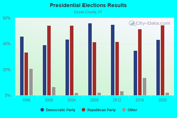
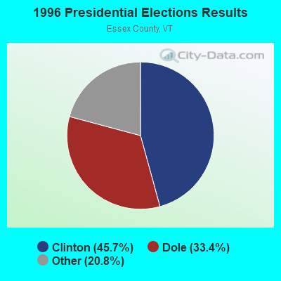
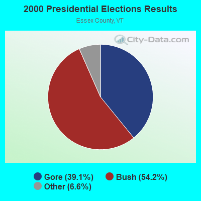
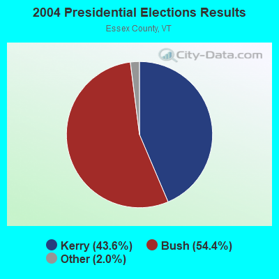
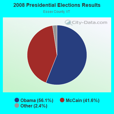

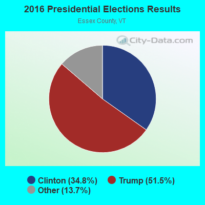
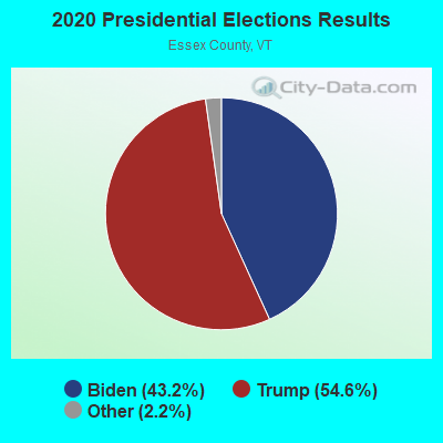
Graphs represent county-level data. Detailed 2008 Election Results
Religion statistics for Bloomfield, VT (based on Essex County data)
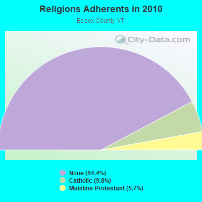
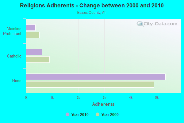
| Religion | Adherents | Congregations |
|---|---|---|
| Catholic | 619 | 2 |
| Mainline Protestant | 360 | 11 |
| Other | 3 | - |
| None | 5,324 | - |
Food Environment Statistics:
| Essex County: | 3.08 / 10,000 pop. |
| Vermont: | 3.84 / 10,000 pop. |
| Essex County: | 6.16 / 10,000 pop. |
| State: | 6.40 / 10,000 pop. |
| Here: | 15.40 / 10,000 pop. |
| State: | 11.52 / 10,000 pop. |
| This county: | 6.7% |
| Vermont: | 6.8% |
| Essex County: | 25.1% |
| Vermont: | 22.3% |
| This county: | 11.3% |
| State: | 13.3% |
Strongest AM radio stations in Bloomfield:
- WCHP (760 AM; 35 kW; CHAMPLAIN, NY; Owner: CHAMPLAIN RADIO, INC.)
- WTME (780 AM; 10 kW; RUMFORD, ME; Owner: MOUNTAIN VALLEY BROADCASTING, INC.)
- WRKO (680 AM; 50 kW; BOSTON, MA; Owner: ENTERCOM BOSTON LICENSE, LLC)
- WICY (1490 AM; 50 kW; MALONE, NY; Owner: CARTIER COMMUNICATIONS INC.)
- WDEV (550 AM; 5 kW; WATERBURY, VT; Owner: RADIO VERMONT, INC.)
- WNNZ (640 AM; 50 kW; WESTFIELD, MA; Owner: CLEAR CHANNEL BROADCASTING LICENSES, INC.)
- WCRN (830 AM; 50 kW; WORCESTER, MA; Owner: CARTER BROADCASTING CORPORATION)
- WEEI (850 AM; 50 kW; BOSTON, MA; Owner: ENTERCOM BOSTON LICENSE, LLC)
- WTWN (1100 AM; daytime; 5 kW; WELLS RIVER, VT; Owner: PUFFER BROADCASTING, INC.)
- WGY (810 AM; 50 kW; SCHENECTADY, NY; Owner: CLEAR CHANNEL BROADCASTING LICENSES, INC.)
- WBZ (1030 AM; 50 kW; BOSTON, MA; Owner: INFINITY BROADCASTING OPERATIONS, INC.)
- WKOX (1200 AM; 50 kW; FRAMINGHAM, MA; Owner: CAPSTAR TX LIMITED PARTNERSHIP)
- WALE (990 AM; 50 kW; GREENVILLE, RI; Owner: NORTH AMERICAN BROADCASTING CO., INC.)
Strongest FM radio stations in Bloomfield:
- WPKQ (103.7 FM; NORTH CONWAY, NH; Owner: CITADEL BROADCASTING COMPANY)
- WGMT (97.7 FM; LYNDON, VT; Owner: VERMONT BROADCAST ASSOCIATES, INC.)
- WHOM (94.9 FM; MT. WASHINGTON, NH; Owner: CITADEL BROADCASTING COMPANY)
- WMTK (106.3 FM; LITTLETON, NH; Owner: VERMONT BROADCAST ASSOCIATES, INC.)
- WXXS (102.3 FM; LANCASTER, NH; Owner: BARRY P. LUNDERVILLE)
- WLKC (103.3 FM; WATERBURY, VT; Owner: RADIO BROADCASTING SERVICES, INC.)
- WVPS (107.9 FM; BURLINGTON, VT; Owner: VERMONT PUBLIC RADIO)
- WEZF (92.9 FM; BURLINGTON, VT; Owner: CAPSTAR TX LIMITED PARTNERSHIP)
- WCVT (101.7 FM; STOWE, VT; Owner: RADIO VERMONT CLASSICS, L.L.C.)
- WTOS-FM (105.1 FM; SKOWHEGAN, ME; Owner: CAPSTAR TX LIMITED PARTNERSHIP)
- WVFM (105.7 FM; CAMPTON, NH; Owner: DEVON BROADCASTING COMPANY, INC.)
- WMOO (92.1 FM; DERBY CENTER, VT; Owner: NORTHSTAR MEDIA, INC.)
- WDOT (95.7 FM; DANVILLE, VT; Owner: MONTPELIER BROADCASTING INC)
- WNCS (104.7 FM; MONTPELIER, VT; Owner: MONTPELIER BROADCASTING, INC.)
- W243AE (96.5 FM; ORLEANS, VT; Owner: CHRISTIAN MINISTRIES, INC.)
- WLOB-FM (96.3 FM; RUMFORD, ME; Owner: ATLANTIC COAST RADIO, LLC)
- WCKJ (90.5 FM; ST. JOHNSBURY, VT; Owner: CHRISTIAN MINISTRIES, INC.)
- WKXH (105.5 FM; ST. JOHNSBURY, VT; Owner: VERMONT BROADCAST ASSOCIATES, INC.)
Bloomfield fatal accident list:
Dec 30, 1999 02:15 PM, Sr-105, Vehicles: 2, Persons: 3, Fatalities: 1
Jan 1, 1988 01:00 PM, Th 7, Vehicles: 1, Persons: 3, Fatalities: 1
Oct 19, 1986 87:99 PM, Vt102, Vehicles: 1, Persons: 1, Fatalities: 1, Drunk persons involved: 1
Jun 24, 1982 02:30 AM, Vt1105, Vehicles: 1, Persons: 5, Fatalities: 2, Drunk persons involved: 1
- National Bridge Inventory (NBI) Statistics
- 9Number of bridges
- 92ft / 27.6mTotal length
- $4,379,000Total costs
- 4,271Total average daily traffic
- 337Total average daily truck traffic
FCC Registered Amateur Radio Licenses:
1- Call Sign: N4CQC, Licensee ID: L00297372, Grant Date: 04/02/2018, Expiration Date: 04/02/2028, Certifier: Ralph W Dame, Registrant: Ralph W Dame, 53 Spur Rd, Bloomfield, VT 05905-9749
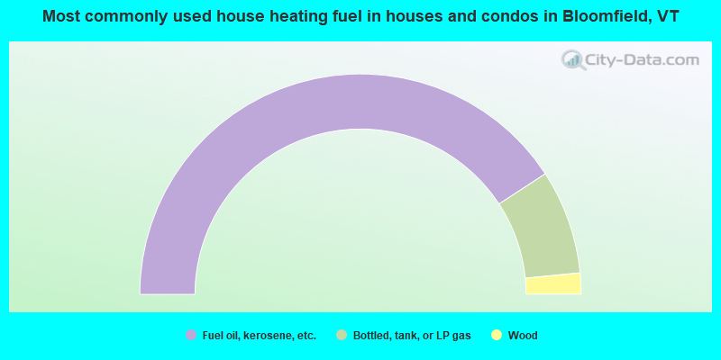
- 81.6%Fuel oil, kerosene, etc.
- 15.3%Bottled, tank, or LP gas
- 3.1%Wood
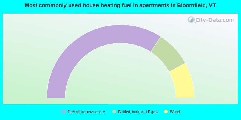
- 68.4%Fuel oil, kerosene, etc.
- 15.8%Bottled, tank, or LP gas
- 15.8%Wood
Bloomfield compared to Vermont state average:
- Median house value below state average.
- Unemployed percentage below state average.
- Black race population percentage below state average.
- Hispanic race population percentage significantly below state average.
- Median age above state average.
- Renting percentage significantly below state average.
- Length of stay since moving in significantly above state average.
- Number of rooms per house significantly below state average.
- House age significantly below state average.
- Number of college students below state average.
- Percentage of population with a bachelor's degree or higher significantly below state average.