Big Bottom, Washington
Submit your own pictures of this place and show them to the world
- OSM Map
- General Map
- Google Map
- MSN Map

| Males: 1,808 | |
| Females: 1,766 |
| Median resident age: | 44.1 years |
| Washington median age: | 35.3 years |
Zip code: 98377
| Big Bottom: | $61,056 |
| WA: | $91,306 |
Estimated per capita income in 2022: $35,999 (it was $17,786 in 2000)
Big Bottom CCD income, earnings, and wages data
Estimated median house or condo value in 2022: $296,852 (it was $89,400 in 2000)
| Big Bottom: | $296,852 |
| WA: | $569,500 |
Mean prices in 2022: all housing units: $376,342; detached houses: $412,728; townhouses or other attached units: $208,842; in 2-unit structures: $276,072; in 3-to-4-unit structures: $295,255; in 5-or-more-unit structures: $233,707; mobile homes: $266,018; occupied boats, rvs, vans, etc.: $88,764
Detailed information about poverty and poor residents in Big Bottom, WA


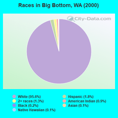
- 3,18195.6%White alone
- 591.8%Hispanic
- 431.3%Two or more races
- 290.9%American Indian alone
- 80.2%Black alone
- 40.1%Asian alone
- 40.1%Native Hawaiian and Other
Pacific Islander alone
Races in Big Bottom detailed stats: ancestries, foreign born residents, place of birth
 Recent articles from our blog. Our writers, many of them Ph.D. graduates or candidates, create easy-to-read articles on a wide variety of topics.
Current Local Time: PST time zone
Land area: 676.7 square miles.
Population density: 5.3 people per square mile (very low).

| Big Bottom CCD: | 1.2% ($1,073) |
| Washington: | 1.2% ($1,915) |
Nearest city with pop. 50,000+: Graham-Thrift, WA (42.0 miles  , pop. 56,970).
Nearest city with pop. 200,000+: East Seattle, WA (76.6 miles , pop. 480,100).
Nearest city with pop. 1,000,000+: Los Angeles, CA (879.7 miles , pop. 3,694,820).
Nearest cities:
), ), ), Latitude: 46.54 N, Longitude: 121.81 W
Area code commonly used in this area: 360


| Here: | 6.3% |
| Washington: | 4.6% |
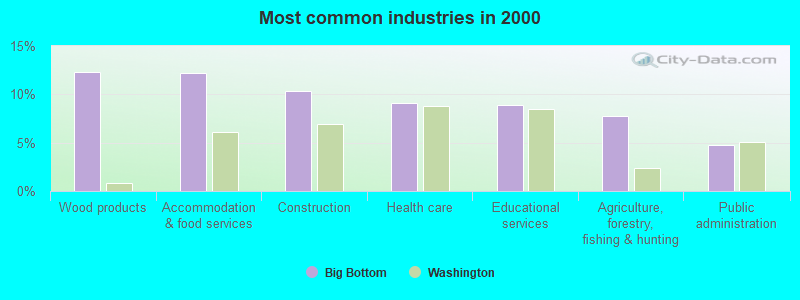
- Wood products (12.3%)
- Accommodation & food services (12.2%)
- Construction (10.4%)
- Health care (9.1%)
- Educational services (8.9%)
- Agriculture, forestry, fishing & hunting (7.8%)
- Public administration (4.8%)
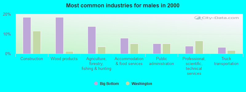
- Construction (18.4%)
- Wood products (18.4%)
- Agriculture, forestry, fishing & hunting (13.8%)
- Accommodation & food services (8.0%)
- Public administration (5.1%)
- Professional, scientific, technical services (3.8%)
- Truck transportation (3.3%)
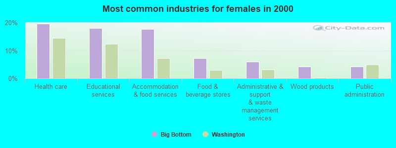
- Health care (19.6%)
- Educational services (18.1%)
- Accommodation & food services (17.6%)
- Food & beverage stores (7.3%)
- Administrative & support & waste management services (6.0%)
- Wood products (4.3%)
- Public administration (4.3%)

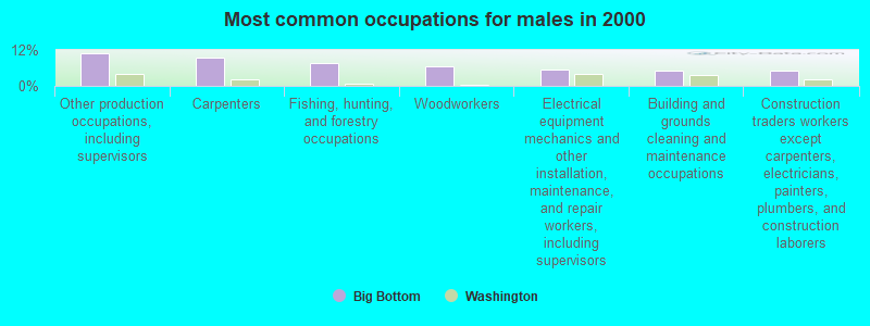
- Other production occupations, including supervisors (6.9%)
- Carpenters (5.3%)
- Woodworkers (4.8%)
- Building and grounds cleaning and maintenance occupations (4.5%)
- Fishing, hunting, and forestry occupations (4.3%)
- Cashiers (4.1%)
- Health technologists and technicians (3.8%)
- Other production occupations, including supervisors (10.8%)
- Carpenters (9.5%)
- Fishing, hunting, and forestry occupations (7.6%)
- Woodworkers (6.6%)
- Electrical equipment mechanics and other installation, maintenance, and repair workers, including supervisors (5.5%)
- Building and grounds cleaning and maintenance occupations (5.0%)
- Construction traders workers except carpenters, electricians, painters, plumbers, and construction laborers (5.0%)
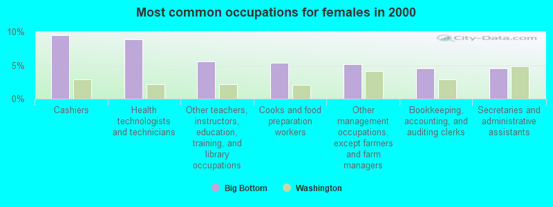
- Cashiers (9.5%)
- Health technologists and technicians (8.8%)
- Other teachers, instructors, education, training, and library occupations (5.6%)
- Cooks and food preparation workers (5.4%)
- Other management occupations, except farmers and farm managers (5.2%)
- Bookkeeping, accounting, and auditing clerks (4.5%)
- Secretaries and administrative assistants (4.5%)
Average climate in Big Bottom, Washington
Based on data reported by over 4,000 weather stations


(lower is better)
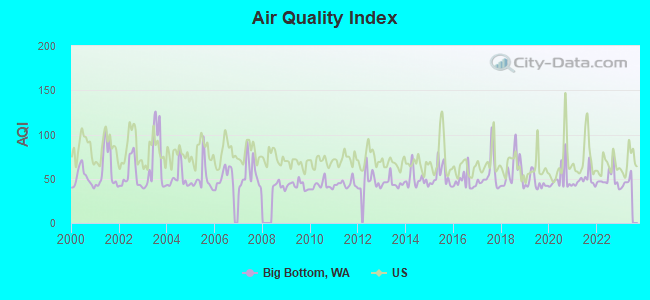
Air Quality Index (AQI) level in 2022 was 49.9. This is significantly better than average.
| City: | 49.9 |
| U.S.: | 72.6 |
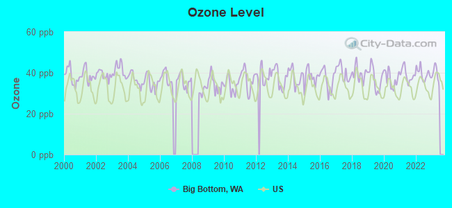
Ozone [ppb] level in 2022 was 39.5. This is about average. Closest monitor was 14.9 miles away from the city center.
| City: | 39.5 |
| U.S.: | 33.3 |
Earthquake activity:
Big Bottom-area historical earthquake activity is significantly above Washington state average. It is 1515% greater than the overall U.S. average.On 4/13/1949 at 19:55:42, a magnitude 7.0 (7.0 UK, Class: Major, Intensity: VIII - XII) earthquake occurred 59.2 miles away from Big Bottom center, causing $80,000,000 total damage
On 2/28/2001 at 18:54:32, a magnitude 6.8 (6.5 MB, 6.6 MS, 6.8 MW, Class: Strong, Intensity: VII - IX) earthquake occurred 52.9 miles away from Big Bottom center, causing $2,000,000,000 total damage and $305,000,000 insured losses
On 2/28/2001 at 18:54:32, a magnitude 6.8 (6.8 MD, Depth: 32.2 mi) earthquake occurred 60.7 miles away from Big Bottom center
On 4/29/1965 at 15:28:43, a magnitude 6.6 (6.6 UK) earthquake occurred 59.4 miles away from Big Bottom center, causing $28,000,000 total damage
On 1/31/1922 at 13:17:28, a magnitude 7.6 (7.6 UK) earthquake occurred 445.0 miles away from Big Bottom center
On 7/3/1999 at 01:43:54, a magnitude 5.8 (5.4 MB, 5.5 MS, 5.8 MW, 5.3 ME, Depth: 25.2 mi, Class: Moderate, Intensity: VI - VII) earthquake occurred 76.6 miles away from Big Bottom center
Magnitude types: body-wave magnitude (MB), duration magnitude (MD), energy magnitude (ME), surface-wave magnitude (MS), moment magnitude (MW)
Natural disasters:
The number of natural disasters in Lewis County (29) is a lot greater than the US average (15).Major Disasters (Presidential) Declared: 26
Emergencies Declared: 1
Causes of natural disasters: Floods: 21, Storms: 15, Mudslides: 11, Landslides: 10, Winter Storms: 8, Winds: 4, Snows: 3, Heavy Rains: 2, Earthquake: 1, Hurricane: 1, Tornado: 1, Volcanic Eruption: 1, Other: 1 (Note: some incidents may be assigned to more than one category).
Colleges/universities with over 2000 students nearest to Big Bottom:
- Pierce College at Puyallup (about 49 miles; Puyallup, WA; Full-time enrollment: 2,529)
- Pacific Lutheran University (about 52 miles; Tacoma, WA; FT enrollment: 3,548)
- Clover Park Technical College (about 55 miles; Lakewood, WA; FT enrollment: 4,185)
- Centralia College (about 57 miles; Centralia, WA; FT enrollment: 2,354)
- Green River Community College (about 57 miles; Auburn, WA; FT enrollment: 7,425)
- Pierce College at Fort Steilacoom (about 57 miles; Lakewood, WA; FT enrollment: 5,228)
- University of Washington-Tacoma Campus (about 58 miles; Tacoma, WA; FT enrollment: 3,788)
Points of interest:
Notable locations in Big Bottom: Lost Lake Lookout (A), Soda Springs Campground (B), Tatoosh Lookout (C), North Fork Campground (D), Box Canyon Picnic Area (E), La Wis Wis Campground (F), Coal Creek Forest Camp (G), Ricksecker Point (H), Canyon Rim View Point (I), Skeelter Shelter (J), River Bar Campground (K), Tower Rock Campground (L), Bypass Camp (M), Nickel Creek Shelter (N), Blue Lake Creek Campground (O), Packwood Guard Station (P), Packwood Lake Resort (Q), Blue Lake Camp Picnic Area (R), Packwood Lake Trailhead (S), Johnson Creek Snowmobile Area (T). Display/hide their locations on the map
Cemetery: Evergreen Cemetery (1). Display/hide its location on the map
Lakes, reservoirs, and swamps: Tower Rock Beaver Ponds (A), Black Rock Pond (B), Benchmark Lake (C), Coyote Lake (D), Fir Lake (E), Wright Lake (F), Pipe Lake (G), Sheep Lake (H). Display/hide their locations on the map
Streams, rivers, and creeks: Beaver Bill Creek (A), Brownie Creek (B), Burton Creek (C), Camp Creek (D), Carlton Creek (E), Chimney Creek (F), Clear Fork Cowlitz River (G), Coal Creek (H), Cortright Creek (I). Display/hide their locations on the map
| This place: | 2.1 people |
| Washington: | 2.5 people |
| This place: | 59.0% |
| Whole state: | 64.4% |
| This place: | 7.6% |
| Whole state: | 7.7% |
Likely homosexual households (counted as self-reported same-sex unmarried-partner households)
- Lesbian couples: 0.1% of all households
- Gay men: 0.6% of all households
| This place: | 17.5% |
| Whole state: | 10.6% |
| This place: | 13.0% |
| Whole state: | 4.6% |
For population 15 years and over in Big Bottom:
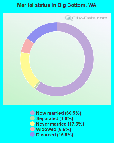
- Never married: 17.3%
- Now married: 60.5%
- Separated: 1.0%
- Widowed: 6.6%
- Divorced: 15.5%
For population 25 years and over in Big Bottom:
- High school or higher: 74.9%
- Bachelor's degree or higher: 9.2%
- Graduate or professional degree: 1.4%
- Unemployed: 13.0%
- Mean travel time to work (commute): 25.2 minutes

| Here: | 9.2 |
| Washington average: | 11.3 |

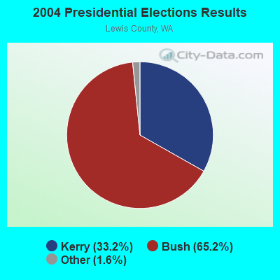
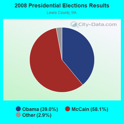
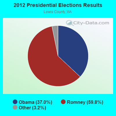
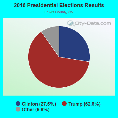
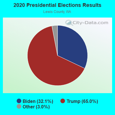
Graphs represent county-level data. Detailed 2008 Election Results
Religion statistics for Big Bottom, WA (based on Lewis County data)
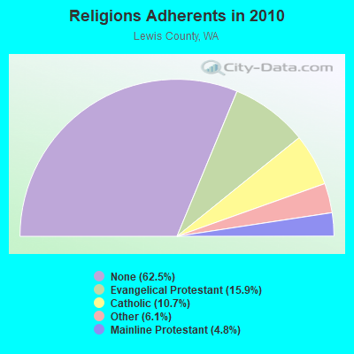
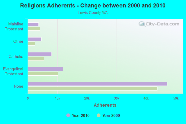
| Religion | Adherents | Congregations |
|---|---|---|
| Evangelical Protestant | 11,961 | 66 |
| Catholic | 8,102 | 10 |
| Other | 4,637 | 16 |
| Mainline Protestant | 3,621 | 20 |
| None | 47,134 | - |
Food Environment Statistics:
| Here: | 3.54 / 10,000 pop. |
| Washington: | 2.06 / 10,000 pop. |
| This county: | 1.63 / 10,000 pop. |
| State: | 1.18 / 10,000 pop. |
| Lewis County: | 5.17 / 10,000 pop. |
| Washington: | 2.67 / 10,000 pop. |
| Lewis County: | 8.16 / 10,000 pop. |
| Washington: | 8.26 / 10,000 pop. |
| Here: | 9.8% |
| Washington: | 7.7% |
| Lewis County: | 34.4% |
| Washington: | 25.7% |
| Here: | 10.0% |
| State: | 13.9% |
Strongest AM radio stations in Big Bottom:
- KJR (950 AM; 50 kW; SEATTLE, WA)
- KIRO (710 AM; 50 kW; SEATTLE, WA; Owner: ENTERCOM SEATTLE LICENSE, LLC)
- KTTH (770 AM; 50 kW; SEATTLE, WA; Owner: ENTERCOM SEATTLE LICENSE, LLC)
- KGNW (820 AM; 50 kW; BURIEN-SEATTLE, WA; Owner: INSPIRATION MEDIA, INC.)
- KPAM (860 AM; 50 kW; TROUTDALE, OR; Owner: PAMPLIN BROADCASTING-OREGON, INC.)
- KYCW (1090 AM; 50 kW; SEATTLE, WA; Owner: INFINITY RADIO SUBSIDIARY OPERATIONS INC.)
- KPOJ (620 AM; 50 kW; PORTLAND, OR; Owner: CITICASTERS LICENSES, L.P.)
- KIXI (880 AM; 50 kW; MERCER ISLAND/SEATTL, WA; Owner: BELLEVUE RADIO, INC.)
- KOMO (1000 AM; 50 kW; SEATTLE, WA; Owner: FISHER BROADCASTING - SEATTLE RADIO, L.L.C.)
- KXL (750 AM; 50 kW; PORTLAND, OR; Owner: ROSE CITY RADIO CORPORATION)
- KOTK (1080 AM; 50 kW; PORTLAND, OR; Owner: FISHER BROADCASTING - PORTLAND RADIO, L.L.C.)
- KNWX (1210 AM; 28 kW; AUBURN-FEDERAL WAY, WA; Owner: ENTERCOM SEATTLE LICENSE, LLC)
- KKAD (1550 AM; 50 kW; VANCOUVER, WA; Owner: PAMPLIN BROADCASTING-WASHINGTON, INC)
Strongest FM radio stations in Big Bottom:
- KXXO (96.1 FM; OLYMPIA, WA; Owner: 3 CITIES, INC.)
- K201EX (88.1 FM; GREENWATER, WA; Owner: CALVARY CHAPEL OF TWIN FALLS, INC.)
- K273AI (102.5 FM; ARIEL, WA; Owner: CALVARY CHAPEL OF TWIN FALLS, INC.)
- KMNT (102.9 FM; CENTRALIA, WA; Owner: CITICASTERS LICENSES, L.P.)
- KBSG-FM (97.3 FM; TACOMA, WA; Owner: ENTERCOM SEATTLE LICENSE, LLC)
- KZOK-FM (102.5 FM; SEATTLE, WA; Owner: INFINITY RADIO SUBSIDIARY OPERATIONS INC.)
- KBKS (106.1 FM; TACOMA, WA; Owner: INFINITY RADIO SUBSIDIARY OPERATIONS INC.)
- KING-FM (98.1 FM; SEATTLE, WA; Owner: CLASSIC RADIO, INC.)
- KLSY-FM (92.5 FM; BELLEVUE, WA; Owner: BELLEVUE RADIO INC.)
- KPLU-FM (88.5 FM; TACOMA, WA; Owner: PACIFIC LUTHERAN UNIVERSITY, INC.)
- KWJZ (98.9 FM; SEATTLE, WA; Owner: ORCA RADIO, INC.)
- KMPS-FM (94.1 FM; SEATTLE, WA; Owner: INFINITY RADIO SUBSIDIARY OPERATIONS INC.)
- KRQT (107.1 FM; CASTLE ROCK, WA; Owner: ENTERCOM LONGVIEW LICENSE, LLC)
- KFNK (104.9 FM; EATONVILLE, WA; Owner: ACKERLEY MEDIA GROUP, INC.)
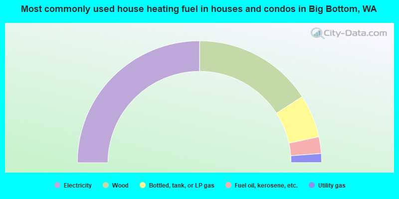
- 50.0%Electricity
- 31.7%Wood
- 11.4%Bottled, tank, or LP gas
- 4.4%Fuel oil, kerosene, etc.
- 2.4%Utility gas
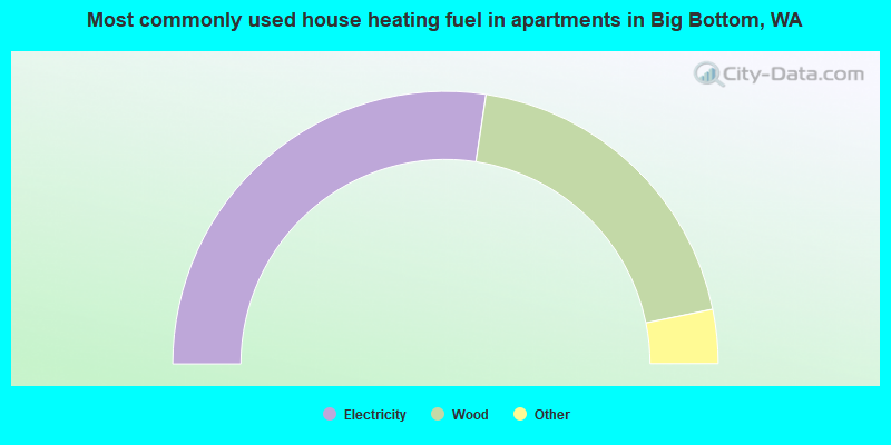
- 54.7%Electricity
- 38.8%Wood
- 3.4%No fuel used
- 3.1%Bottled, tank, or LP gas
Big Bottom compared to Washington state average:
- Median house value below state average.
- Black race population percentage significantly below state average.
- Hispanic race population percentage significantly below state average.
- Median age significantly above state average.
- Foreign-born population percentage significantly below state average.
- Renting percentage below state average.
- Length of stay since moving in significantly above state average.
- Number of rooms per house significantly below state average.
- House age significantly below state average.
- Percentage of population with a bachelor's degree or higher significantly below state average.