Bedford, Tennessee
Submit your own pictures of this place and show them to the world
- OSM Map
- General Map
- Google Map
- MSN Map

| Males: 1,922 | |
| Females: 1,839 |
| Median resident age: | 36.3 years |
| Tennessee median age: | 35.9 years |
Zip code: 37160
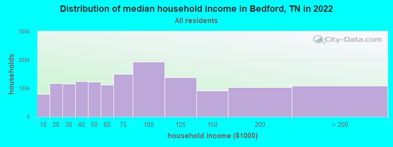
| Bedford: | $61,925 |
| TN: | $65,254 |
Estimated per capita income in 2022: $26,965 (it was $15,502 in 2000)
Bedford CCD income, earnings, and wages data
Estimated median house or condo value in 2022: $269,361 (it was $78,300 in 2000)
| Bedford: | $269,361 |
| TN: | $284,800 |
Detailed information about poverty and poor residents in Bedford, TN


- 3,03995.1%White alone
- 932.9%Black alone
- 391.2%Hispanic
- 130.4%Two or more races
- 80.3%American Indian alone
- 20.06%Asian alone
- 10.03%Other race alone

Races in Bedford detailed stats: ancestries, foreign born residents, place of birth
 Recent articles from our blog. Our writers, many of them Ph.D. graduates or candidates, create easy-to-read articles on a wide variety of topics.
Current Local Time: CST time zone
Elevation: 805 feet
Land area: 95.7 square miles.
Population density: 39 people per square mile (very low).

| Bedford CCD: | 0.6% ($478) |
| Tennessee: | 0.8% ($715) |
Nearest city with pop. 50,000+: Murfreesboro, TN  (29.5 miles , pop. 68,816).
Nearest city with pop. 200,000+: Nashville-Davidson, TN (49.3 miles , pop. 545,524).
Nearest city with pop. 1,000,000+: Chicago, IL (445.5 miles , pop. 2,896,016).
Nearest cities:
), ), ), Latitude: 35.46 N, Longitude: 86.58 W
Area code commonly used in this area: 931

| Here: | 3.0% |
| Tennessee: | 3.0% |
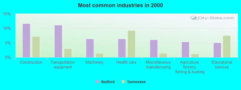
- Construction (11.7%)
- Transportation equipment (11.2%)
- Machinery (6.4%)
- Health care (6.4%)
- Miscellaneous manufacturing (6.1%)
- Agriculture, forestry, fishing & hunting (5.4%)
- Educational services (5.1%)
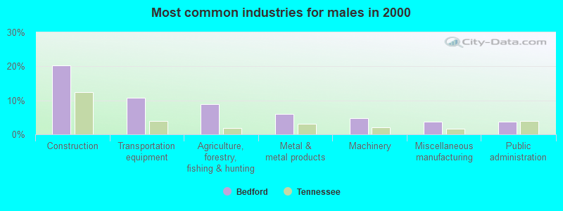
- Construction (20.2%)
- Transportation equipment (10.8%)
- Agriculture, forestry, fishing & hunting (8.9%)
- Metal & metal products (5.9%)
- Machinery (4.8%)
- Miscellaneous manufacturing (3.8%)
- Public administration (3.8%)
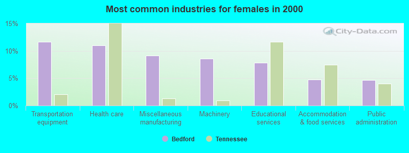
- Transportation equipment (11.7%)
- Health care (11.0%)
- Miscellaneous manufacturing (9.1%)
- Machinery (8.5%)
- Educational services (7.9%)
- Accommodation & food services (4.7%)
- Public administration (4.6%)

- Other production occupations, including supervisors (6.5%)
- Metal workers and plastic workers (5.8%)
- Building and grounds cleaning and maintenance occupations (4.7%)
- Assemblers and fabricators (4.1%)
- Electrical equipment mechanics and other installation, maintenance, and repair workers, including supervisors (4.0%)
- Driver/sales workers and truck drivers (4.0%)
- Farmers and farm managers (3.6%)

- Metal workers and plastic workers (7.7%)
- Driver/sales workers and truck drivers (7.1%)
- Farmers and farm managers (6.3%)
- Electrical equipment mechanics and other installation, maintenance, and repair workers, including supervisors (6.3%)
- Building and grounds cleaning and maintenance occupations (5.6%)
- Construction traders workers except carpenters, electricians, painters, plumbers, and construction laborers (5.3%)
- Vehicle and mobile equipment mechanics, installers, and repairers (4.7%)

- Other production occupations, including supervisors (9.5%)
- Other office and administrative support workers, including supervisors (6.1%)
- Secretaries and administrative assistants (5.7%)
- Cashiers (5.2%)
- Material recording, scheduling, dispatching, and distributing workers (4.7%)
- Assemblers and fabricators (4.1%)
- Other sales and related occupations, including supervisors (4.1%)
Average climate in Bedford, Tennessee
Based on data reported by over 4,000 weather stations


Tornado activity:
Bedford-area historical tornado activity is slightly above Tennessee state average. It is 93% greater than the overall U.S. average.
On 4/16/1998, a category F5 (max. wind speeds 261-318 mph) tornado 19.2 miles away from the Bedford place center killed 3 people and injured 36 people and caused $13 million in damages.
On 4/3/1974, a category F5 tornado 32.7 miles away from the place center killed 16 people and injured 190 people.
Earthquake activity:
Bedford-area historical earthquake activity is significantly above Tennessee state average. It is 178% greater than the overall U.S. average.On 4/29/2003 at 08:59:39, a magnitude 4.9 (4.4 MB, 4.6 MW, 4.9 LG, Class: Light, Intensity: IV - V) earthquake occurred 85.7 miles away from Bedford center
On 4/18/2008 at 09:36:59, a magnitude 5.4 (5.1 MB, 4.8 MS, 5.4 MW, 5.2 MW, Class: Moderate, Intensity: VI - VII) earthquake occurred 219.3 miles away from Bedford center
On 4/29/2003 at 08:59:39, a magnitude 4.6 (4.6 MW, Depth: 12.3 mi) earthquake occurred 85.6 miles away from Bedford center
On 4/18/2008 at 09:36:59, a magnitude 5.2 (5.2 MW, Depth: 8.9 mi) earthquake occurred 219.3 miles away from the city center
On 6/18/2002 at 17:37:15, a magnitude 5.0 (4.3 MB, 4.6 MW, 5.0 LG) earthquake occurred 187.2 miles away from Bedford center
On 1/18/1999 at 07:00:53, a magnitude 4.8 (4.8 MB, 4.0 LG, Depth: 0.6 mi) earthquake occurred 147.1 miles away from the city center
Magnitude types: regional Lg-wave magnitude (LG), body-wave magnitude (MB), surface-wave magnitude (MS), moment magnitude (MW)
Natural disasters:
The number of natural disasters in Bedford County (13) is near the US average (15).Major Disasters (Presidential) Declared: 9
Emergencies Declared: 2
Causes of natural disasters: Floods: 7, Storms: 5, Winter Storms: 4, Tornadoes: 3, Flash Flood: 1, Heavy Rain: 1, Hurricane: 1, Ice Storm: 1, Landslide: 1, Mudslide: 1, Snowfall: 1, Other: 1 (Note: some incidents may be assigned to more than one category).
Hospitals and medical centers near Bedford:
- BEDFORD CO NH (Nursing Home, about 7 miles away; SHELBYVILLE, TN)
- CHRISTIAN CARE CENTER OF BEDFORD COUNTY, LLC (Nursing Home, about 7 miles away; SHELBYVILLE, TN)
- HERITAGE HOME HEALTH (Home Health Center, about 8 miles away; SHELBYVILLE, TN)
- DCI SHELBYVILLE (Dialysis Facility, about 8 miles away; SHELBYVILLE, TN)
- MARSHALL MEDICAL CENTER Critical Access Hospitals (about 12 miles away; LEWISBURG, TN)
- NHC HEALTHCARE, OAKWOOD (Nursing Home, about 14 miles away; LEWISBURG, TN)
- MERIHIL NH (Nursing Home, about 15 miles away; LEWISBURG, TN)
Colleges/universities with over 2000 students nearest to Bedford:
- Motlow State Community College (about 17 miles; Tullahoma, TN; Full-time enrollment: 2,915)
- Middle Tennessee State University (about 30 miles; Murfreesboro, TN; FT enrollment: 21,628)
- Columbia State Community College (about 32 miles; Columbia, TN; FT enrollment: 3,383)
- Lipscomb University (about 47 miles; Nashville, TN; FT enrollment: 3,827)
- Alabama A & M University (about 47 miles; Normal, AL; FT enrollment: 4,524)
- Belmont University (about 49 miles; Nashville, TN; FT enrollment: 5,795)
- Trevecca Nazarene University (about 49 miles; Nashville, TN; FT enrollment: 2,223)
Points of interest:
Notable locations in Bedford: Rising Star Ranch (A), Chanthaphone Farm (B), Eastfield Farms (C), Volunteer Fire Services Station 3 / WBTS Volunteer Fire Department (D), Volunteer Fire Services Station 8 / WBTS Volunteer Fire Department (E). Display/hide their locations on the map
Churches in Bedford include: Haskins Chapel (A), Lone Oak Church of Christ (B), Pleasant Grove United Methodist Church (C), Bedford Church of Christ (D), Richmond Church (E), Lebanon Church (F), Bethlehem Church (G), New Bethel Baptist Church (H), Big Spring Church (I). Display/hide their locations on the map
Cemeteries: Jones Cemetery (1), Knight Cemetery (2), Adams Cemetery (3), Redd Cemetery (4), Tucker Cemetery (5), Richmond Cemetery (6), Card Cemetery (7). Display/hide their locations on the map
Streams, rivers, and creeks: Ledford Branch (A), Dryland Creek (B), Cortner Branch (C), Comstock Branch (D), Buchanan Branch (E), Fall Creek (F), Branchville Branch (G), Simmons Branch (H), Sims Spring Branch (I). Display/hide their locations on the map
| This place: | 2.7 people |
| Tennessee: | 2.5 people |
| This place: | 72.4% |
| Whole state: | 69.8% |
| This place: | 4.8% |
| Whole state: | 4.2% |
Likely homosexual households (counted as self-reported same-sex unmarried-partner households)
- Lesbian couples: 0.3% of all households
- Gay men: 0.2% of all households
| This place: | 12.7% |
| Whole state: | 13.5% |
| This place: | 4.2% |
| Whole state: | 5.8% |
2 people in other workers' dormitories in 2000
For population 15 years and over in Bedford:

- Never married: 15.8%
- Now married: 70.9%
- Separated: 0.4%
- Widowed: 4.5%
- Divorced: 8.8%
For population 25 years and over in Bedford:
- High school or higher: 71.7%
- Bachelor's degree or higher: 8.5%
- Graduate or professional degree: 2.6%
- Unemployed: 4.3%
- Mean travel time to work (commute): 31.1 minutes


| Here: | 12.9 |
| Tennessee average: | 13.3 |
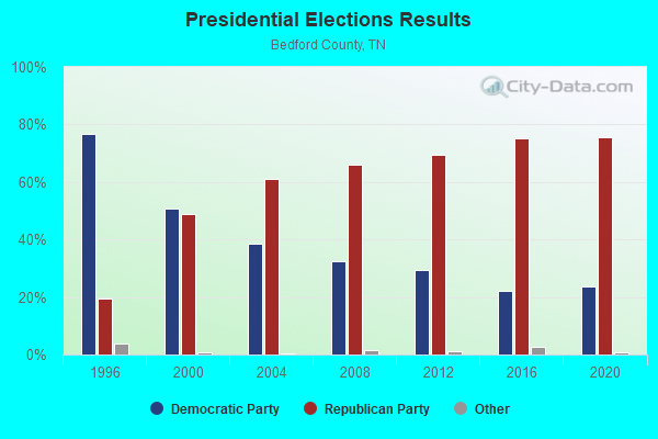
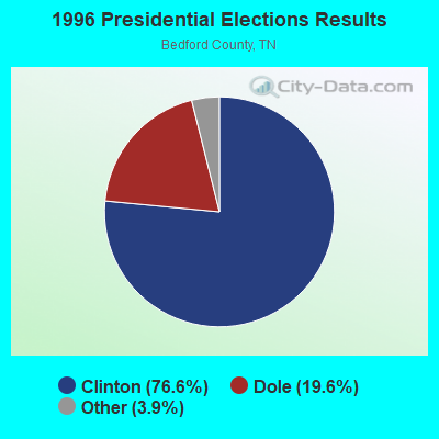
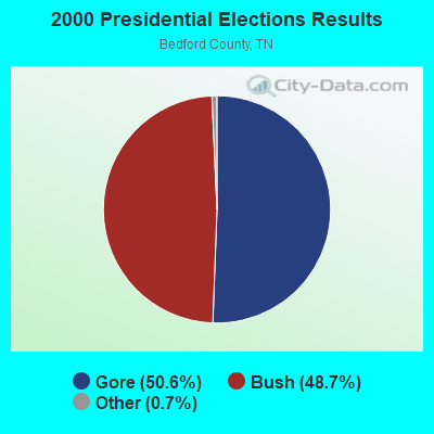

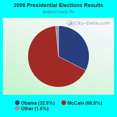


Graphs represent county-level data. Detailed 2008 Election Results
Religion statistics for Bedford, TN (based on Bedford County data)
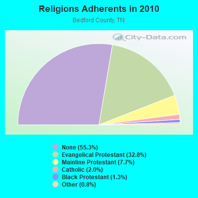
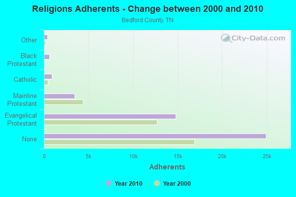
| Religion | Adherents | Congregations |
|---|---|---|
| Evangelical Protestant | 14,794 | 71 |
| Mainline Protestant | 3,449 | 23 |
| Catholic | 900 | 1 |
| Black Protestant | 607 | 5 |
| Other | 375 | 2 |
| None | 24,933 | - |
Food Environment Statistics:
| Bedford County: | 2.74 / 10,000 pop. |
| Tennessee: | 1.99 / 10,000 pop. |
| Bedford County: | 0.23 / 10,000 pop. |
| Tennessee: | 0.17 / 10,000 pop. |
| Bedford County: | 0.46 / 10,000 pop. |
| Tennessee: | 0.65 / 10,000 pop. |
| This county: | 5.70 / 10,000 pop. |
| Tennessee: | 5.16 / 10,000 pop. |
| Bedford County: | 4.79 / 10,000 pop. |
| Tennessee: | 6.56 / 10,000 pop. |
| Bedford County: | 10.7% |
| Tennessee: | 11.4% |
| Bedford County: | 28.2% |
| State: | 30.2% |
| Bedford County: | 17.1% |
| Tennessee: | 13.5% |
Strongest AM radio stations in Bedford:
- WLIJ (1580 AM; 5 kW; SHELBYVILLE, TN)
- WSM (650 AM; 50 kW; NASHVILLE, TN; Owner: GAYLORD ENTERTAINMENT COMPANY)
- WAMB (1160 AM; 50 kW; DONELSON, TN; Owner: GREAT SOUTHERN BROADCASTING COMPANY, INC.)
- WWAM (820 AM; daytime; 50 kW; JASPER, TN; Owner: SHELTON BROADCASTING SYSTEM)
- WLOR (1550 AM; 50 kW; HUNTSVILLE, AL; Owner: BCA RADIO, LLC)
- WKDA (1200 AM; 50 kW; NASHVILLE, TN; Owner: RADIO NASHVILLE, INC.)
- WNQM (1300 AM; 50 kW; NASHVILLE, TN; Owner: WNQM. INC.)
- WZNG (1400 AM; 1 kW; SHELBYVILLE, TN; Owner: HOPKINS-HALL BROADCASTING, INC.)
- WBXR (1140 AM; daytime; 15 kW; HAZEL GREEN, AL; Owner: LOW COUNTRY CORPORATION, INC.)
- WLAC (1510 AM; 50 kW; NASHVILLE, TN; Owner: CAPSTAR TX LIMITED PARTNERSHIP)
- WFLI (1070 AM; 50 kW; LOOKOUT MOUNTAIN, TN; Owner: WFLI, INC.)
- WMGC (810 AM; 5 kW; MURFREESBORO, TN; Owner: RADIO 810 NASHVILLE, LIMITED)
- WAXO (1220 AM; 1 kW; LEWISBURG, TN; Owner: MARSHALL COUNTY RADIO CORPORATION)
Strongest FM radio stations in Bedford:
- WWTN (99.7 FM; MANCHESTER, TN; Owner: CUMULUS LICENSING CORP.)
- WFCM-FM (91.7 FM; MURFREESBORO, TN; Owner: THE MOODY BIBLE INSTITUTE OF CHICAGO)
- WBUZ (102.9 FM; LA VERGNE, TN; Owner: WYCQ, INC)
- WRLT (100.1 FM; FRANKLIN, TN; Owner: TUNED-IN BROADCASTING, INC)
- WAHR (99.1 FM; HUNTSVILLE, AL; Owner: BCA RADIO, LLC)
- WUSX (93.3 FM; TULLAHOMA, TN; Owner: TENNNESSE VALLEY RADIO, INC)
- WKDF (103.3 FM; NASHVILLE, TN; Owner: CITADEL BROADCASTING COMPANY)
- WNRQ (105.9 FM; NASHVILLE, TN; Owner: CAPSTAR TX LIMITED PARTNERSHIP)
- W263AE (100.5 FM; LEWISBURG, TN; Owner: WEATHER RADAR ASSOCIATES)
- WYTM-FM (105.5 FM; FAYETTEVILLE, TN; Owner: TIME BROADCASTERS, INC.)
- WPLN-FM (90.3 FM; NASHVILLE, TN; Owner: NASHVILLE PUBLIC RADIO)
- WSIX-FM (97.9 FM; NASHVILLE, TN; Owner: CAPSTAR TX LIMITED PARTNERSHIP)
- WMOT (89.5 FM; MURFREESBORO, TN; Owner: MIDDLE TENNESSEE STATE UNIVERSITY)
- W289AC (105.7 FM; HUNTSVILLE, AL; Owner: WILLIAM PAXTON ROGERS)
- WAYM (88.7 FM; COLUMBIA, TN; Owner: WAY-FM MEDIA GROUP, INC.)
- WSM-FM (95.5 FM; NASHVILLE, TN; Owner: CUMULUS LICENSING CORP.)
- WZYP (104.3 FM; ATHENS, AL; Owner: ATHENS BROADCASTING COMPANY, INC.)
- W278AA (103.5 FM; MADISON, AL; Owner: TENNESSEE VALLEY RADIO, INC.)
- WFTZ (101.5 FM; MANCHESTER, TN; Owner: PHASE TWO COMMUNICATIONS, INC.)
- WJJM-FM (94.3 FM; LEWISBURG, TN; Owner: MARTHA M. LINGNER, EXECUTRIX)
TV broadcast stations around Bedford:
- WNAB (Channel 58; NASHVILLE, TN; Owner: NASHVILLE LICENSE HOLDINGS, L.L.C.)
- WSMV-TV (Channel 4; NASHVILLE, TN; Owner: MEREDITH CORPORATION)
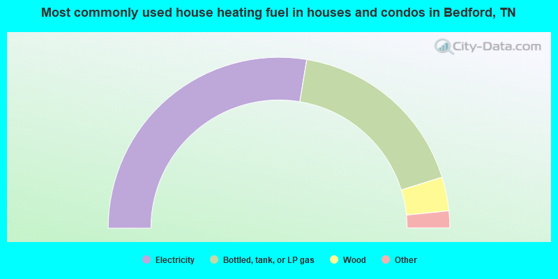
- 55.2%Electricity
- 35.2%Bottled, tank, or LP gas
- 6.4%Wood
- 1.3%Utility gas
- 1.3%Fuel oil, kerosene, etc.
- 0.7%Solar energy
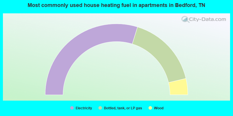
- 59.6%Electricity
- 33.1%Bottled, tank, or LP gas
- 7.4%Wood
Bedford compared to Tennessee state average:
- Unemployed percentage significantly below state average.
- Black race population percentage significantly below state average.
- Hispanic race population percentage significantly below state average.
- Foreign-born population percentage significantly below state average.
- Renting percentage significantly below state average.
- Length of stay since moving in significantly above state average.
- Number of rooms per house significantly below state average.
- House age significantly below state average.
- Number of college students below state average.
- Percentage of population with a bachelor's degree or higher significantly below state average.