Balls Ferry, Georgia
Submit your own pictures of this place and show them to the world
- OSM Map
- General Map
- Google Map
- MSN Map

| Males: 862 | |
| Females: 979 |
| Median resident age: | 37.8 years |
| Georgia median age: | 33.4 years |
Zip code: 31096
| Balls Ferry: | $52,972 |
| GA: | $72,837 |
Estimated per capita income in 2022: $27,073 (it was $13,843 in 2000)
Balls Ferry CCD income, earnings, and wages data
Estimated median house or condo value in 2022: $110,521 (it was $42,600 in 2000)
| Balls Ferry: | $110,521 |
| GA: | $297,400 |
Mean prices in 2022: all housing units: $159,104; detached houses: $184,886; mobile homes: $65,842
Detailed information about poverty and poor residents in Balls Ferry, GA


- 1,04962.7%White alone
- 60636.2%Black alone
- 90.5%Hispanic
- 70.4%American Indian alone
- 30.2%Two or more races

Races in Balls Ferry detailed stats: ancestries, foreign born residents, place of birth
 Recent articles from our blog. Our writers, many of them Ph.D. graduates or candidates, create easy-to-read articles on a wide variety of topics.
Current Local Time: EST time zone
Land area: 81.7 square miles.
Population density: 23 people per square mile (very low).

| Balls Ferry CCD: | 1.2% ($492) |
| Georgia: | 0.9% ($919) |
Nearest city with pop. 50,000+: Macon, GA  (50.0 miles , pop. 97,255).
Nearest city with pop. 200,000+: Atlanta, GA (118.4 miles , pop. 416,474).
Nearest city with pop. 1,000,000+: Philadelphia, PA (659.3 miles , pop. 1,517,550).
Nearest cities:
), ), Latitude: 32.71 N, Longitude: 82.79 W
Area code commonly used in this area: 478


| Here: | 2.6% |
| Georgia: | 2.9% |

- Public administration (17.1%)
- Construction (11.1%)
- Apparel (8.1%)
- Health care (7.8%)
- Educational services (6.6%)
- Social assistance (5.5%)
- Truck transportation (4.4%)

- Construction (18.4%)
- Public administration (14.8%)
- Machinery (6.6%)
- Mining, quarrying, oil & gas extraction (5.4%)
- Truck transportation (5.1%)
- Paper (4.8%)
- Health care (4.8%)

- Public administration (19.5%)
- Apparel (12.7%)
- Health care (11.0%)
- Social assistance (10.1%)
- Educational services (8.4%)
- Textile mills & textile products (6.8%)
- Truck transportation (3.6%)

- Textile, apparel, and furnishings workers (7.7%)
- Other office and administrative support workers, including supervisors (7.0%)
- Secretaries and administrative assistants (6.4%)
- Electrical equipment mechanics and other installation, maintenance, and repair workers, including supervisors (6.3%)
- Driver/sales workers and truck drivers (5.5%)
- Child care workers (4.9%)
- Material recording, scheduling, dispatching, and distributing workers (3.8%)

- Electrical equipment mechanics and other installation, maintenance, and repair workers, including supervisors (12.1%)
- Driver/sales workers and truck drivers (9.1%)
- Metal workers and plastic workers (6.3%)
- Other protective service workers, including supervisors (5.4%)
- Other sales and related occupations, including supervisors (5.1%)
- Other management occupations, except farmers and farm managers (4.8%)
- Construction traders workers except carpenters, electricians, painters, plumbers, and construction laborers (4.8%)

- Textile, apparel, and furnishings workers (15.9%)
- Secretaries and administrative assistants (13.3%)
- Other office and administrative support workers, including supervisors (12.0%)
- Child care workers (10.1%)
- Other food preparation and serving workers, including supervisors (5.5%)
- Registered nurses (4.2%)
- Sales representatives, services, wholesale and manufacturing (4.2%)
Average climate in Balls Ferry, Georgia
Based on data reported by over 4,000 weather stations


(lower is better)

Air Quality Index (AQI) level in 2023 was 98.1. This is worse than average.
| City: | 98.1 |
| U.S.: | 72.6 |

Particulate Matter (PM2.5) [µg/m3] level in 2023 was 12.2. This is significantly worse than average. Closest monitor was 17.9 miles away from the city center.
| City: | 12.2 |
| U.S.: | 8.1 |
Tornado activity:
Balls Ferry-area historical tornado activity is slightly below Georgia state average. It is 3% smaller than the overall U.S. average.
On 1/13/1972, a category F3 (max. wind speeds 158-206 mph) tornado 26.2 miles away from the Balls Ferry place center injured 21 people and caused between $500,000 and $5,000,000 in damages.
On 5/11/2008, a category F3 tornado 28.2 miles away from the place center .
Earthquake activity:
Balls Ferry-area historical earthquake activity is significantly above Georgia state average. It is 12% smaller than the overall U.S. average.On 8/2/1974 at 08:52:09, a magnitude 4.9 (4.3 MB, 4.9 LG, Class: Light, Intensity: IV - V) earthquake occurred 82.3 miles away from Balls Ferry center
On 11/22/1974 at 05:25:55, a magnitude 4.7 (4.7 MB) earthquake occurred 154.2 miles away from the city center
On 4/29/2003 at 08:59:39, a magnitude 4.9 (4.4 MB, 4.6 MW, 4.9 LG) earthquake occurred 205.1 miles away from Balls Ferry center
On 8/9/2020 at 12:07:37, a magnitude 5.1 (5.1 MW, Depth: 4.7 mi, Class: Moderate, Intensity: VI - VII) earthquake occurred 277.8 miles away from Balls Ferry center
On 2/15/2014 at 03:23:38, a magnitude 4.1 (4.1 MW, Depth: 3.2 mi) earthquake occurred 86.5 miles away from the city center
On 8/21/1992 at 16:31:55, a magnitude 4.4 (4.1 MB, 4.1 LG, 4.4 LG, Depth: 6.2 mi) earthquake occurred 156.9 miles away from the city center
Magnitude types: regional Lg-wave magnitude (LG), body-wave magnitude (MB), moment magnitude (MW)
Natural disasters:
The number of natural disasters in Johnson County (11) is smaller than the US average (15).Major Disasters (Presidential) Declared: 7
Emergencies Declared: 3
Causes of natural disasters: Floods: 4, Storms: 4, Hurricanes: 2, Winter Storms: 2, Drought: 1, Tornado: 1, Tropical Storm: 1, Other: 1 (Note: some incidents may be assigned to more than one category).
Hospitals and medical centers near Balls Ferry:
- WRIGHTSVILLE MANOR INC (Nursing Home, about 4 miles away; WRIGHTSVILLE, GA)
- WRIGHTSVILLE NURSING HOME (Nursing Home, about 4 miles away; WRIGHTSVILLE, GA)
- WRIGHTSVILLE DIALYSIS (Dialysis Facility, about 4 miles away; WRIGHTSVILLE, GA)
- HOSPICE OF LAURENS COUNTY, INC (Hospital, about 14 miles away; DUBLIN, GA)
- SERENITY HOSPICE CARE LLC (Hospital, about 14 miles away; DUBLIN, GA)
- SHAMROCK DIALYSIS (Dialysis Facility, about 14 miles away; DUBLIN, GA)
- OCONEE HEALTH AND REHABILITATION (Nursing Home, about 15 miles away; OCONEE, GA)
Colleges/universities with over 2000 students nearest to Balls Ferry:
- East Georgia State College (about 29 miles; Swainsboro, GA; Full-time enrollment: 2,345)
- Georgia Military College-Distance Learning Campuses (about 37 miles; Milledgeville, GA; FT enrollment: 6,438)
- Georgia College and State University (about 37 miles; Milledgeville, GA; FT enrollment: 6,271)
- Mercer University (about 51 miles; Macon, GA; FT enrollment: 6,297)
- Central Georgia Technical College (about 53 miles; Warner Robins, GA; FT enrollment: 6,829)
- Middle Georgia State College (about 56 miles; Macon, GA; FT enrollment: 7,091)
- Georgia Southern University (about 62 miles; Statesboro, GA; FT enrollment: 18,824)
Points of interest:
Notable locations in Balls Ferry: Buckeye Volunteer Fire Department (A), Piney Mount Fire Department (B), Raines Crossroads Fire Department (C). Display/hide their locations on the map
Churches in Balls Ferry include: Arline Church (A), Bethel Church (B), Burnett Grove Church (C), Daniel Grove Church (D), Ivey Church (E), Maple Spring Church (F), Mitchell Grove Church (G), Mount Pleasant Church (H), Pine Hill Church (I). Display/hide their locations on the map
Cemeteries: Brachley Cemetery (1), Dent Cemetery (2), Martin Cemetery (3), Moody Cemetery (4), Waters Cemetery (5), Williams Cemetery (6), Hightower Cemetery (7). Display/hide their locations on the map
Lakes and reservoirs: Davis Pond (A), Parkers Ponds (B), Goat Pond (C), Gilbert Pond (D), Herds Pond (E), Davis Lake (F). Display/hide their locations on the map
Streams, rivers, and creeks: Fords Creek (A), Gin Branch (B), Little Buckeye Creek (C). Display/hide their locations on the map
| This place: | 2.6 people |
| Georgia: | 2.6 people |
| This place: | 62.1% |
| Whole state: | 70.7% |
| This place: | 4.5% |
| Whole state: | 4.8% |
Likely homosexual households (counted as self-reported same-sex unmarried-partner households)
- Lesbian couples: 0.2% of all households
- Gay men: 0.2% of all households
| This place: | 24.1% |
| Whole state: | 13.0% |
| This place: | 8.8% |
| Whole state: | 6.1% |
For population 15 years and over in Balls Ferry:

- Never married: 17.8%
- Now married: 64.8%
- Separated: 6.0%
- Widowed: 8.7%
- Divorced: 8.7%
For population 25 years and over in Balls Ferry:
- High school or higher: 64.0%
- Bachelor's degree or higher: 5.6%
- Graduate or professional degree: 1.7%
- Unemployed: 3.8%
- Mean travel time to work (commute): 28.5 minutes


| Here: | 14.3 |
| Georgia average: | 13.3 |
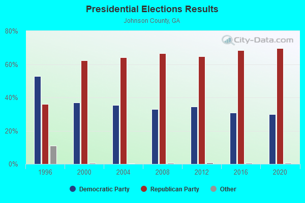
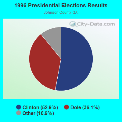
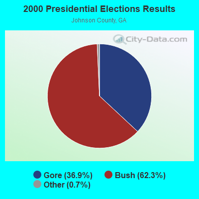
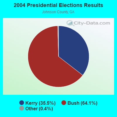
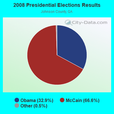


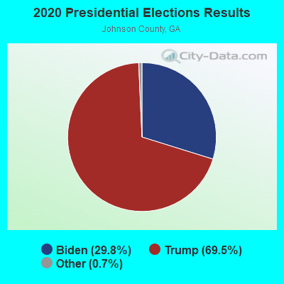
Graphs represent county-level data. Detailed 2008 Election Results
Religion statistics for Balls Ferry, GA (based on Johnson County data)
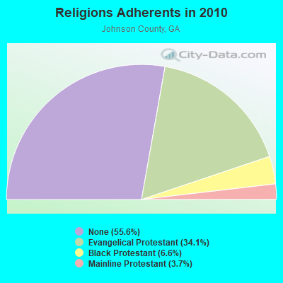
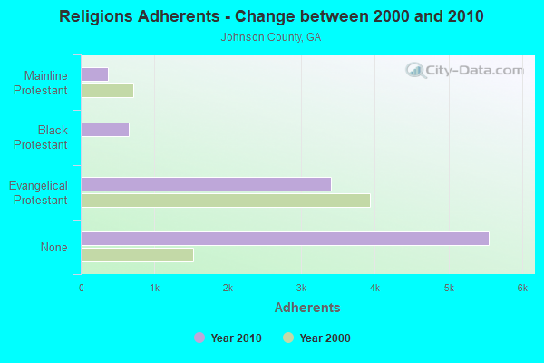
| Religion | Adherents | Congregations |
|---|---|---|
| Evangelical Protestant | 3,399 | 26 |
| Black Protestant | 659 | 6 |
| Mainline Protestant | 369 | 8 |
| Catholic | - | - |
| None | 5,553 | - |
Food Environment Statistics:
| Johnson County: | 3.15 / 10,000 pop. |
| State: | 5.12 / 10,000 pop. |
| Johnson County: | 2.10 / 10,000 pop. |
| Georgia: | 7.41 / 10,000 pop. |
| Johnson County: | 12.1% |
| Georgia: | 10.4% |
| This county: | 32.2% |
| Georgia: | 27.8% |
| Johnson County: | 13.3% |
| State: | 14.6% |
Strongest AM radio stations in Balls Ferry:
- WMLT (1330 AM; 5 kW; DUBLIN, GA; Owner: STATE BROADCASTING CORPORATION)
- WMAC (940 AM; 50 kW; MACON, GA; Owner: CUMULUS LICENSING CORP.)
- WXJO (1120 AM; daytime; 10 kW; GORDON, GA; Owner: ROBERTS COMMUNICATIONS, INC.)
- WGST (640 AM; 50 kW; ATLANTA, GA; Owner: CITICASTERS LICENSES, L.P.)
- WSB (750 AM; 50 kW; ATLANTA, GA; Owner: CXR HOLDINGS, INC.)
- WCNN (680 AM; 50 kW; NORTH ATLANTA, GA; Owner: DICKEY BROADCASTING COMPANY)
- WNNG (1350 AM; 15 kW; WARNER ROBINS, GA; Owner: CHASE BROADCASTING, INC.)
- WGUN (1010 AM; 50 kW; ATLANTA, GA; Owner: WGUN, INC.)
- WVOP (970 AM; 5 kW; VIDALIA, GA; Owner: VIDALIA COMMUNICATIONS CORPORATION)
- WLFJ (660 AM; daytime; 50 kW; GREENVILLE, SC; Owner: CLEAR CHANNEL BROADCASTING LICENSES, INC.)
- WBAJ (890 AM; daytime; 50 kW; BLYTHEWOOD, SC; Owner: FAMILY FIRST)
- WXLI (1230 AM; 1 kW; DUBLIN, GA; Owner: LAURENS COUNTY BROADCASTING CO., INC)
- WMLB (1160 AM; 50 kW; EAST POINT, GA; Owner: ATLANTA AREA BROADCASTING, INC.)
Strongest FM radio stations in Balls Ferry:
- WDBN (107.5 FM; WRIGHTSVILLE, GA; Owner: D/B/A DOWDY PARTNERS)
- WQZY (95.9 FM; DUBLIN, GA; Owner: STATE BROADCASTING CORPORATION)
- WELT (98.1 FM; SWAINSBORO, GA; Owner: LACOM COMMUNICATIONS, INC.)
- WKKZ (92.7 FM; DUBLIN, GA; Owner: KIRBY BROADCASTING COMPANY)
- WDCO-FM (89.7 FM; COCHRAN, GA; Owner: GEORGIA PUBLIC TELECOMMUNICATIONS COMMISSION)
- WJFL (101.9 FM; TENNILLE, GA; Owner: FALL LINE MEDIA, INC.)
- WAKB (96.9 FM; WRENS, GA; Owner: RADIO ONE OF AUGUSTA, LLC)
- WMCG (104.9 FM; MILAN, GA; Owner: TEL-DODGE BROADCASTING CO.)
- WKTM (106.1 FM; SOPERTON, GA; Owner: BARINOWSKI INVESTMENT COMPANY)
- WSNT-FM (99.9 FM; SANDERSVILLE, GA; Owner: RADIO STATION WSNT, INC.)
TV broadcast stations around Balls Ferry:
- WDCO-TV (Channel 29; COCHRAN, GA; Owner: GEORGIA PUBLIC TELECOMMUNICATIONS COMMISSION)
- WCES-TV (Channel 20; WRENS, GA; Owner: GEORGIA PUBLIC TELECOMMUNICATIONS COMMISSION)
- W35BB (Channel 35; DUBLIN, GA; Owner: WDIG, LLC)

- 54.9%Electricity
- 40.2%Bottled, tank, or LP gas
- 3.0%Utility gas
- 1.9%Wood

- 70.8%Bottled, tank, or LP gas
- 21.5%Electricity
- 7.7%Wood
Balls Ferry compared to Georgia state average:
- Median house value significantly below state average.
- Unemployed percentage significantly below state average.
- Hispanic race population percentage significantly below state average.
- Foreign-born population percentage significantly below state average.
- Renting percentage significantly below state average.
- Length of stay since moving in significantly above state average.
- Number of rooms per house significantly below state average.
- House age significantly below state average.
- Number of college students below state average.
- Percentage of population with a bachelor's degree or higher significantly below state average.