Bald Knob, Kentucky
Submit your own pictures of this place and show them to the world
- OSM Map
- General Map
- Google Map
- MSN Map

| Males: 729 | |
| Females: 734 |
| Median resident age: | 37.2 years |
| Kentucky median age: | 35.9 years |
Zip code: 40601
| Bald Knob: | $56,300 |
| KY: | $59,341 |
Estimated per capita income in 2022: $27,752 (it was $15,250 in 2000)
Bald Knob CCD income, earnings, and wages data
Estimated median house or condo value in 2022: $163,800 (it was $71,600 in 2000)
| Bald Knob: | $163,800 |
| KY: | $196,300 |
Detailed information about poverty and poor residents in Bald Knob, KY
Compare current foreclosures near Bald Knob, KY:
| Photo | Address | Area | Beds / Baths | Price | Details |
|---|---|---|---|---|---|

|
#1
Alton Station Rd
Lawrenceburg, KY 40342
|
2,414 sq. feet
|
1 baths 3 beds |
show details | |

|
#2
Evergreen Rd
Frankfort, KY 40601
|
2,696 sq. feet
|
2 baths 5 beds |
show details | |

|
#3
Ponder Dr
Shelbyville, KY 40065
|
2,084 sq. feet
|
2 baths 3 beds |
show details | |

|
#4
Donalynn Dr
Frankfort, KY 40601
|
1,806 sq. feet
|
1 baths 2 beds |
show details | |

|
#5
Buck Run Rd
Versailles, KY 40383
|
2,034 sq. feet
|
2 baths 3 beds |
show details | |

|
#6
Graves Rd
Stamping Ground, KY 40379
|
1,152 sq. feet
|
2 baths 2 beds |
show details | |

|
#7
Catwalk Rd
Bagdad, KY 40003
|
2,302 sq. feet
|
2 baths 3 beds |
show details | |

|
#8
Main St
Pleasureville, KY 40057
|
1,087 sq. feet
|
1 baths 3 beds |
show details | |

|
#9
Holmes St
Frankfort, KY 40601
|
2 sq. feet
|
2 baths 3 beds |
show details | |

|
#10
Shady Ln
Midway, KY 40347
|
1,820 sq. feet
|
1 baths 3 beds |
show details |
| Photo | Address | Area | Beds / Baths | Price | Details |
|---|---|---|---|---|---|

|
#11
Main St
Stamping Ground, KY 40379
|
1,080 sq. feet
|
2 baths 4 beds |
show details | |

|
#12
Mccracken Pike
Frankfort, KY 40601
|
1,288 sq. feet
|
1 baths 2 beds |
show details | |

|
#13
Oak Dr
Eminence, KY 40019
|
1,260 sq. feet
|
2 baths 3 beds |
show details | |

|
#14
Squiresville Rd
Owenton, KY 40359
|
1,248 sq. feet
|
2 baths 3 beds |
show details | |

|
#15
Hillcrest Dr
Eminence, KY 40019
|
1,050 sq. feet
|
1 baths 3 beds |
show details | |

|
#16
Highway 127 N
Owenton, KY 40359
|
1,096 sq. feet
|
1 baths 3 beds |
show details | |

|
#17
Fawn Ln
Pleasureville, KY 40057
|
1,152 sq. feet
|
2 baths 3 beds |
show details | |

|
#18
Nordic Ct
Shelbyville, KY 40065
|
1,680 sq. feet
|
2 baths 4 beds |
show details | |

|
#19
Tolle Ct
Eminence, KY 40019
|
1,778 sq. feet
|
1 baths 4 beds |
show details | |

|
#20
Eagle Pass
Shelbyville, KY 40065
|
2,208 sq. feet
|
2 baths 3 beds |
show details |
| Photo | Address | Area | Beds / Baths | Price | Details |
|---|---|---|---|---|---|

|
#21
Casey Ln
Georgetown, KY 40324
|
3,103 sq. feet
|
2 baths 3 beds |
show details | |

|
#22
Joshua Ln
Georgetown, KY 40324
|
1,351 sq. feet
|
2 baths 3 beds |
show details | |

|
#23
Holly Berry Dr
Frankfort, KY 40601
|
- sq. feet
|
2 baths 3 beds |
show details | |

|
#24
Lyons Dr
Frankfort, KY 40601
|
- sq. feet
|
1 baths 3 beds |
show details | |

|
#25
Excel Ct
Frankfort, KY 40601
|
- sq. feet
|
4 baths 6 beds |
show details | |

|
#26
Ridge Rd
Frankfort, KY 40601
|
- sq. feet
|
2 baths 4 beds |
show details | |

|
#27
Louisville Rd Apt 70
Frankfort, KY 40601
|
- sq. feet
|
1 baths 2 beds |
show details | |

|
#28
Marlowe Ct
Frankfort, KY 40601
|
- sq. feet
|
1 baths 3 beds |
show details | |

|
#29
Turnberry Dr
Frankfort, KY 40601
|
- sq. feet
|
2 baths 3 beds |
show details | |

|
#30
Iroquois Trl
Frankfort, KY 40601
|
- sq. feet
|
1 baths 2 beds |
show details |
| Photo | Address | Area | Beds / Baths | Price | Details |
|---|---|---|---|---|---|

|
#31
Donalynn Dr
Frankfort, KY 40601
|
- sq. feet
|
2 baths 3 beds |
show details | |

|
#32
Sioux Trl
Frankfort, KY 40601
|
- sq. feet
|
1 baths 3 beds |
show details | |

|
#33
Ewing St
Frankfort, KY 40601
|
- sq. feet
|
1 baths 2 beds |
show details | |

|
#34
Alfa Dr
Frankfort, KY 40601
|
- sq. feet
|
2 baths 4 beds |
show details | |

|
#35
Beechwood Ave
Frankfort, KY 40601
|
- sq. feet
|
2 baths 3 beds |
show details | |

|
#36
Dressage Ct
Frankfort, KY 40601
|
- sq. feet
|
2 baths 3 beds |
show details | |

|
#37
Sandstone Dr
Frankfort, KY 40601
|
- sq. feet
|
2 baths 3 beds |
show details | |

|
#38
Carla Ct
Frankfort, KY 40601
|
- sq. feet
|
1 baths 3 beds |
show details | |

|
#39
Edgewood Dr
Frankfort, KY 40601
|
- sq. feet
|
1 baths 3 beds |
show details | |

|
#40
Green Wilson Rd
Frankfort, KY 40601
|
- sq. feet
|
1 baths 3 beds |
show details |
| Photo | Address | Area | Beds / Baths | Price | Details |
|---|---|---|---|---|---|

|
#41
Stable Ln
Frankfort, KY 40601
|
- sq. feet
|
1 baths 3 beds |
show details | |

|
#42
Stable Ln
Frankfort, KY 40601
|
- sq. feet
|
2 baths 4 beds |
show details | |

|
#43
Farmers Ln
Frankfort, KY 40601
|
- sq. feet
|
1 baths 3 beds |
show details | |

|
#44
Gratz Rd
Owenton, KY 40359
|
1,344 sq. feet
|
1 baths - beds |
show details | |

|
#45
Roscoe Ct
Frankfort, KY 40601
|
- sq. feet
|
2 baths 3 beds |
show details | |

|
#46
Evergreen Rd
Frankfort, KY 40601
|
- sq. feet
|
1 baths 2 beds |
show details | |

|
#47
Whipporwill Ln
Frankfort, KY 40601
|
- sq. feet
|
1 baths 3 beds |
show details | |

|
#48
Creekstone Ct
Frankfort, KY 40601
|
- sq. feet
|
1 baths 3 beds |
show details | |

|
#49
Cedar Way
Frankfort, KY 40601
|
- sq. feet
|
2 baths 3 beds |
show details | |

|
Check over 1 million property listings on Foreclosure.com!
|
browse all offers | |||

- 1,41798.2%White alone
- 110.8%Hispanic
- 60.4%Black alone
- 50.3%American Indian alone
- 40.3%Two or more races

Races in Bald Knob detailed stats: ancestries, foreign born residents, place of birth
 Recent articles from our blog. Our writers, many of them Ph.D. graduates or candidates, create easy-to-read articles on a wide variety of topics.
Current Local Time: EST time zone
Land area: 49.0 square miles.
Population density: 30 people per square mile (very low).

| Bald Knob CCD: | 0.4% ($308) |
| Kentucky: | 0.8% ($610) |
Nearest city with pop. 50,000+: Fayette, KY  (30.3 miles , pop. 260,512).
Nearest city with pop. 1,000,000+: Chicago, IL (284.5 miles , pop. 2,896,016).
Nearest cities:
), ), ), )Latitude: 38.31 N, Longitude: 84.93 W
Area code commonly used in this area: 502


| Here: | 3.4% |
| Kentucky: | 3.8% |

- Public administration (21.1%)
- Educational services (8.2%)
- Health care (7.4%)
- Truck transportation (6.9%)
- Food & beverage stores (5.4%)
- Finance & insurance (5.4%)
- Construction (4.9%)

- Public administration (22.4%)
- Truck transportation (12.8%)
- Food & beverage stores (12.5%)
- Construction (11.4%)
- Metal & metal products (11.4%)
- Educational services (5.0%)
- Motor vehicle & parts dealers (4.3%)

- Public administration (20.1%)
- Health care (11.1%)
- Educational services (10.6%)
- Finance & insurance (9.5%)
- Gasoline stations (7.0%)
- Accommodation & food services (6.8%)
- Transportation equipment (6.0%)

- Other sales and related occupations, including supervisors (6.6%)
- Other office and administrative support workers, including supervisors (6.0%)
- Secretaries and administrative assistants (6.0%)
- Other production occupations, including supervisors (5.8%)
- Computer specialists (4.6%)
- Cashiers (4.0%)
- Other management occupations, except farmers and farm managers (3.2%)

- Other sales and related occupations, including supervisors (15.3%)
- Other management occupations, except farmers and farm managers (7.5%)
- Other production occupations, including supervisors (7.5%)
- Laborers and material movers, hand (7.1%)
- Driver/sales workers and truck drivers (6.0%)
- Engineers (5.7%)
- Building and grounds cleaning and maintenance occupations (4.3%)

- Secretaries and administrative assistants (10.6%)
- Other office and administrative support workers, including supervisors (8.1%)
- Cashiers (7.0%)
- Computer specialists (6.0%)
- Other healthcare support occupations (5.4%)
- Other production occupations, including supervisors (4.6%)
- Registered nurses (4.1%)
Average climate in Bald Knob, Kentucky
Based on data reported by over 4,000 weather stations


(lower is better)

Air Quality Index (AQI) level in 2004 was 48.7. This is significantly better than average.
| City: | 48.7 |
| U.S.: | 72.6 |

Ozone [ppb] level in 2004 was 23.6. This is significantly better than average. Closest monitor was 10.7 miles away from the city center.
| City: | 23.6 |
| U.S.: | 33.3 |
Tornado activity:
Bald Knob-area historical tornado activity is slightly above Kentucky state average. It is 53% greater than the overall U.S. average.
On 4/3/1974, a category F4 (max. wind speeds 207-260 mph) tornado 19.5 miles away from the Bald Knob place center killed 4 people and injured 122 people and caused between $50,000 and $500,000 in damages.
On 11/22/1992, a category F4 tornado 21.7 miles away from the place center killed one person and injured 10 people and caused between $500,000 and $5,000,000 in damages.
Earthquake activity:
Bald Knob-area historical earthquake activity is significantly above Kentucky state average. It is 80% greater than the overall U.S. average.On 7/27/1980 at 18:52:21, a magnitude 5.2 (5.1 MB, 4.7 MS, 5.0 UK, 5.2 UK, Class: Moderate, Intensity: VI - VII) earthquake occurred 53.9 miles away from the city center
On 4/18/2008 at 09:36:59, a magnitude 5.4 (5.1 MB, 4.8 MS, 5.4 MW, 5.2 MW) earthquake occurred 160.8 miles away from Bald Knob center
On 4/18/2008 at 09:36:59, a magnitude 5.2 (5.2 MW, Depth: 8.9 mi) earthquake occurred 160.8 miles away from the city center
On 9/7/1988 at 02:28:09, a magnitude 4.6 (4.5 MB, 4.6 LG, Class: Light, Intensity: IV - V) earthquake occurred 58.1 miles away from the city center
On 6/10/1987 at 23:48:54, a magnitude 5.1 (4.9 MB, 4.4 MS, 4.6 MS, 5.1 LG) earthquake occurred 163.9 miles away from Bald Knob center
On 6/18/2002 at 17:37:15, a magnitude 5.0 (4.3 MB, 4.6 MW, 5.0 LG) earthquake occurred 156.8 miles away from the city center
Magnitude types: regional Lg-wave magnitude (LG), body-wave magnitude (MB), surface-wave magnitude (MS), moment magnitude (MW)
Natural disasters:
The number of natural disasters in Franklin County (18) is near the US average (15).Major Disasters (Presidential) Declared: 15
Emergencies Declared: 2
Causes of natural disasters: Floods: 12, Storms: 8, Tornadoes: 6, Mudslides: 5, Winter Storms: 5, Landslides: 3, Snowstorms: 2, Blizzard: 1, Heavy Rain: 1, Hurricane: 1, Snow: 1, Wind: 1, Other: 1 (Note: some incidents may be assigned to more than one category).
Hospitals and medical centers near Bald Knob:
Colleges/universities with over 2000 students nearest to Bald Knob:
- Kentucky State University (about 9 miles; Frankfort, KY; Full-time enrollment: 2,112)
- University of Kentucky (about 30 miles; Lexington, KY; FT enrollment: 23,517)
- Bluegrass Community and Technical College (about 31 miles; Lexington, KY; FT enrollment: 8,560)
- Sullivan University (about 41 miles; Louisville, KY; FT enrollment: 5,129)
- The Southern Baptist Theological Seminary (about 42 miles; Louisville, KY; FT enrollment: 2,360)
- Bellarmine University (about 43 miles; Louisville, KY; FT enrollment: 3,180)
- Jefferson Community and Technical College (about 46 miles; Louisville, KY; FT enrollment: 7,950)
Points of interest:
Notable location: Franklin County Fire Department Station 6 (A). Display/hide its location on the map
Churches in Bald Knob include: Harvieland Church (A), Lebanon Church (B), Mount Carmel Church (C), Mount Zion Church (D), North Benson Church (E), Pleasant Ridge Church (F), Pleasant View Church (G). Display/hide their locations on the map
Cemeteries: Bailey Cemetery (1), Sudduth Cemetery (2), Waits Cemetery (3), Moore Cemetery (4), Hutcherson Cemetery (5). Display/hide their locations on the map
Streams, rivers, and creeks: Barrel Branch (A), Tucker Creek (B), Willow Branch (C), Sudduth Branch (D), Bark Branch (E), Marshall Branch (F), North Fork North Benson Creek (G), Quire Branch (H), Goose Creek (I). Display/hide their locations on the map
Park in Bald Knob: Kentucky River Campground (1). Display/hide its location on the map
| This place: | 2.5 people |
| Kentucky: | 2.5 people |
| This place: | 71.8% |
| Whole state: | 66.9% |
| This place: | 7.4% |
| Whole state: | 6.4% |
Likely homosexual households (counted as self-reported same-sex unmarried-partner households)
- Lesbian couples: 0.2% of all households
- Gay men: 0.5% of all households
| This place: | 12.5% |
| Whole state: | 15.8% |
| This place: | 1.6% |
| Whole state: | 6.6% |
For population 15 years and over in Bald Knob:

- Never married: 20.0%
- Now married: 61.1%
- Separated: 1.0%
- Widowed: 4.7%
- Divorced: 14.1%
For population 25 years and over in Bald Knob:
- High school or higher: 67.4%
- Bachelor's degree or higher: 10.9%
- Graduate or professional degree: 4.6%
- Unemployed: 5.0%
- Mean travel time to work (commute): 29.8 minutes


| Here: | 15.4 |
| Kentucky average: | 13.8 |
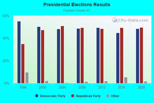
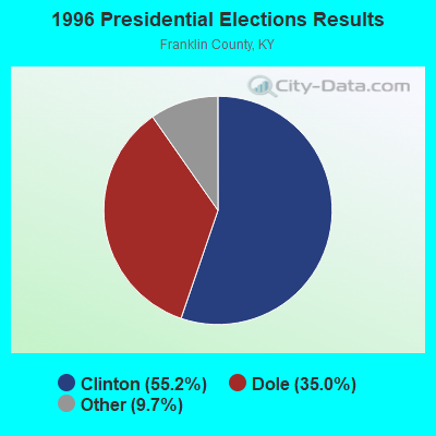
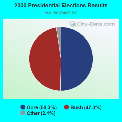
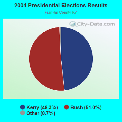

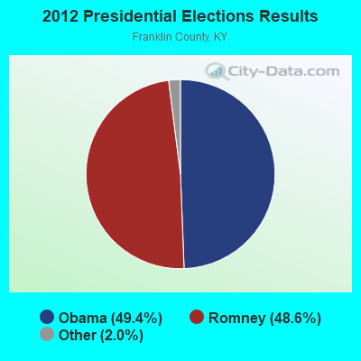
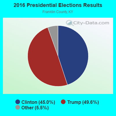
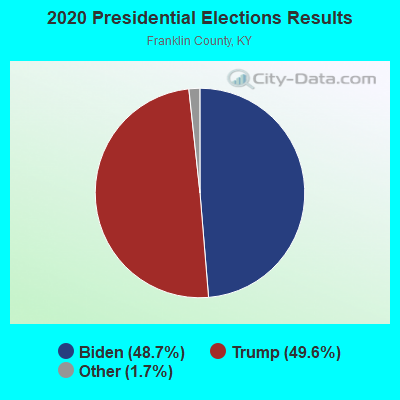
Graphs represent county-level data. Detailed 2008 Election Results
Religion statistics for Bald Knob, KY (based on Franklin County data)
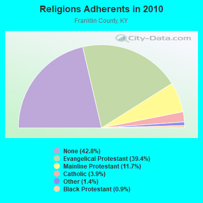
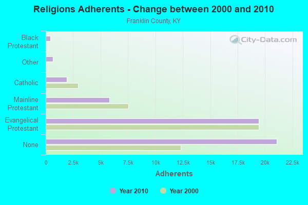
| Religion | Adherents | Congregations |
|---|---|---|
| Evangelical Protestant | 19,409 | 57 |
| Mainline Protestant | 5,783 | 13 |
| Catholic | 1,911 | 1 |
| Other | 673 | 3 |
| Black Protestant | 432 | 3 |
| None | 21,077 | - |
Food Environment Statistics:
| Franklin County: | 1.45 / 10,000 pop. |
| Kentucky: | 2.19 / 10,000 pop. |
| This county: | 0.21 / 10,000 pop. |
| State: | 0.25 / 10,000 pop. |
| Franklin County: | 1.03 / 10,000 pop. |
| Kentucky: | 0.74 / 10,000 pop. |
| Franklin County: | 4.75 / 10,000 pop. |
| State: | 4.36 / 10,000 pop. |
| Here: | 6.61 / 10,000 pop. |
| State: | 5.74 / 10,000 pop. |
| This county: | 11.5% |
| Kentucky: | 11.0% |
| Franklin County: | 31.8% |
| Kentucky: | 30.0% |
| This county: | 21.4% |
| State: | 15.9% |
Strongest AM radio stations in Bald Knob:
- WHAS (840 AM; 50 kW; LOUISVILLE, KY; Owner: CLEAR CHANNEL BROADCASTING LICENSES, INC.)
- WXRA (1580 AM; 10 kW; GEORGETOWN, KY; Owner: CITICASTERS LICENSES, L.P.)
- WVLK (590 AM; 5 kW; LEXINGTON, KY; Owner: CUMULUS LICENSING CORP.)
- WFKY (1490 AM; 1 kW; FRANKFORT, KY; Owner: CLEAR CHANNEL BROADCASTING LICENSES, INC.)
- WSAI (1530 AM; 50 kW; CINCINNATI, OH; Owner: JACOR BROADCASTING CORPORATION)
- WLW (700 AM; 50 kW; CINCINNATI, OH; Owner: JACOR BROADCASTING CORPORATION)
- WLAP (630 AM; 5 kW; LEXINGTON, KY; Owner: CITICASTERS LICENSES, L.P.)
- WXXA (790 AM; 5 kW; LOUISVILLE, KY)
- WTVN (610 AM; 50 kW; COLUMBUS, OH; Owner: CITICASTERS LICENSES, L.P.)
- WKJK (1080 AM; 10 kW; LOUISVILLE, KY; Owner: CLEAR CHANNEL BROADCASTING LICENSES, INC.)
- WLXG (1300 AM; 2 kW; LEXINGTON, KY; Owner: L.M. COMMUNICATIONS, INC)
- WKRC (550 AM; 5 kW; CINCINNATI, OH; Owner: JACOR BROADCASTING CORPORATION)
- WGTK (970 AM; 5 kW; LOUISVILLE, KY; Owner: SALEM MEDIA OF KENTUCKY, INC.)
Strongest FM radio stations in Bald Knob:
- WKED-FM (103.7 FM; FRANKFORT, KY; Owner: CLEAR CHANNEL BROADCASTING LICENSES, INC.)
- WKYW (104.9 FM; FRANKFORT, KY; Owner: CLEAR CHANNEL BROADCASTING LICENSES, INC.)
- W202AZ (88.3 FM; FRANKFORT, KY; Owner: BIBLE BROADCASTING NETWORK, INC.)
- WUKY (91.3 FM; LEXINGTON, KY; Owner: BD. OF TRUSTEES UNIV. OF KENTUCKY)
- WTSZ-FM (105.7 FM; EMINENCE, KY; Owner: METRO EAST CBC, INC.)
- WJZO (101.7 FM; SHELBYVILLE, KY; Owner: CLEAR CHANNEL BROADCASTING LICENSES, INC.)
- WVLK-FM (92.9 FM; LEXINGTON, KY; Owner: CUMULUS LICENSING CORP.)
- WBTF (107.9 FM; MIDWAY, KY; Owner: L.M. COMMUNICATIONS OF KENTUCKY, LLC)
- WKQQ (100.1 FM; WINCHESTER, KY; Owner: CITICASTERS LICENSES, L.P.)
- WMXL (94.5 FM; LEXINGTON, KY; Owner: CITICASTERS LICENSES, INC.)
- WRVG-FM (89.9 FM; GEORGETOWN, KY; Owner: GEORGETOWN COLLEGE)
- WKYL (102.1 FM; LAWRENCEBURG, KY; Owner: DAVENPORT BROADCASTING, INC.)
- WLXO (96.1 FM; STAMPING GROUND, KY; Owner: CLARITY COMMUNICATIONS, INC.)
- WXZZ (103.3 FM; GEORGETOWN, KY; Owner: CUMULUS LICENSING CORP.)
- WTFX-FM (100.5 FM; LOUISVILLE, KY; Owner: CLEAR CHANNEL BROADCASTING LICENSES, INC.)
- WIOK (107.5 FM; FALMOUTH, KY; Owner: HAMMOND BROADCASTING, INC.)
- WBUL-FM (98.1 FM; LEXINGTON, KY; Owner: CITICASTERS LICENSES, L.P.)
- WJMM-FM (99.3 FM; HARRODSBURG, KY; Owner: MORTENSON BROADCASTING COMPANY OF CENTRAL KENTUCKY, LLC)
- WNKR (106.5 FM; WILLIAMSTOWN, KY; Owner: GRANT COUNTY BROADCASTERS, INC)
TV broadcast stations around Bald Knob:
- WAVE (Channel 3; LOUISVILLE, KY; Owner: LIBCO, INC.)
- WKON (Channel 52; OWENTON, KY; Owner: KENTUCKY AUTHORITY FOR EDUCATIONAL TV)
- WDKY-TV (Channel 56; DANVILLE, KY; Owner: WDKY LICENSEE, LLC)
- W24BW (Channel 24; LOUISVILLE, KY; Owner: GREATER LOUISVILLE COMMUNICATIONS)
- WKYT-TV (Channel 27; LEXINGTON, KY; Owner: WKYT LICENSEE CORP.)
- WTVQ-TV (Channel 36; LEXINGTON, KY; Owner: MEDIA GENERAL COMMUNICATIONS, INC.)

- 51.5%Bottled, tank, or LP gas
- 29.5%Electricity
- 16.9%Wood
- 2.1%Fuel oil, kerosene, etc.

- 54.5%Bottled, tank, or LP gas
- 29.1%Wood
- 16.4%Fuel oil, kerosene, etc.
Bald Knob compared to Kentucky state average:
- Unemployed percentage significantly below state average.
- Black race population percentage significantly below state average.
- Hispanic race population percentage significantly below state average.
- Foreign-born population percentage significantly below state average.
- Renting percentage below state average.
- Length of stay since moving in significantly above state average.
- Number of rooms per house significantly below state average.
- House age significantly below state average.
- Number of college students below state average.
- Percentage of population with a bachelor's degree or higher below state average.