Attapulgus, Georgia
Submit your own pictures of this city and show them to the world
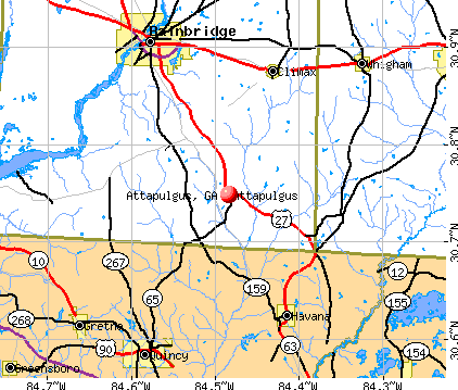
- OSM Map
- General Map
- Google Map
- MSN Map
Population change since 2000: -8.9%
 |
| Males: 268 | |
| Females: 180 |
| Median resident age: | 35.7 years |
| Georgia median age: | 37.6 years |
Zip codes: 39815.
| Attapulgus: | $34,735 |
| GA: | $72,837 |
Estimated per capita income in 2022: $17,825 (it was $11,204 in 2000)
Attapulgus city income, earnings, and wages data
Estimated median house or condo value in 2022: $81,395 (it was $40,300 in 2000)
| Attapulgus: | $81,395 |
| GA: | $297,400 |
Mean prices in 2022: all housing units: $91,772; detached houses: $99,625; mobile homes: $73,501
Median gross rent in 2022: $855.
(37.7% for White Non-Hispanic residents, 27.1% for Black residents, 89.7% for Hispanic or Latino residents, 91.4% for other race residents, 52.0% for two or more races residents)
Detailed information about poverty and poor residents in Attapulgus, GA
Compare current foreclosures near Attapulgus, GA:
| Photo | Address | Area | Beds / Baths | Price | Details |
|---|---|---|---|---|---|

|
#1
E Griffin Ave
Attapulgus, GA 39815
|
- sq. feet
|
- baths - beds |
show details | |

|
#2
Thomas Ave
Attapulgus, GA 39815
|
- sq. feet
|
- baths - beds |
show details | |

|
#3
N Main St
Attapulgus, GA 39815
|
- sq. feet
|
- baths - beds |
show details | |

|
#4
Wautauga Rd
Attapulgus, GA 39815
|
- sq. feet
|
- baths - beds |
show details | |

|
#5
Village Ln
Attapulgus, GA 39815
|
1,250 sq. feet
|
- baths - beds |
show details | |

|
#6
Red Fox Run
Tallahassee, FL 32303
|
1,900 sq. feet
|
3 baths 4 beds |
$209,900
|
show details |

|
#7
Magnolia Drive
Quincy, FL 32351
|
704 sq. feet
|
1 baths 2 beds |
show details | |

|
#8
High Bridge Rd
Quincy, FL 32351
|
1,620 sq. feet
|
2 baths 3 beds |
show details | |

|
#9
Timber Run
Havana, FL 32333
|
1,595 sq. feet
|
2 baths 3 beds |
show details | |

|
#10
E College St
Bainbridge, GA 39819
|
1,636 sq. feet
|
3 baths 3 beds |
show details |
| Photo | Address | Area | Beds / Baths | Price | Details |
|---|---|---|---|---|---|

|
#11
Wisteria Dr
Bainbridge, GA 39819
|
1,496 sq. feet
|
1 baths 3 beds |
show details | |

|
#12
E Jefferson St
Quincy, FL 32351
|
1,472 sq. feet
|
1 baths 4 beds |
show details | |

|
#13
Mildred St
Bainbridge, GA 39817
|
1,973 sq. feet
|
2 baths 3 beds |
show details | |

|
#14
E Bellamy Dr
Quincy, FL 32351
|
900 sq. feet
|
1 baths 2 beds |
show details | |

|
#15
SW 3rd St
Havana, FL 32333
|
1,512 sq. feet
|
2 baths 3 beds |
show details | |

|
#16
Newberry Rd
Quincy, FL 32352
|
806 sq. feet
|
3 baths 5 beds |
show details | |

|
#17
SW 3rd St
Havana, FL 32333
|
2,019 sq. feet
|
1 baths 3 beds |
show details | |

|
#18
Power Line Rd
Quincy, FL 32352
|
1,536 sq. feet
|
2 baths 3 beds |
show details | |

|
#19
E 11th Ave
Havana, FL 32333
|
1,248 sq. feet
|
2 baths 3 beds |
show details | |

|
#20
E 12th Ave
Havana, FL 32333
|
1,150 sq. feet
|
1 baths 2 beds |
show details |
| Photo | Address | Area | Beds / Baths | Price | Details |
|---|---|---|---|---|---|

|
#21
SW 4th St
Havana, FL 32333
|
1,350 sq. feet
|
1 baths 3 beds |
show details | |

|
#22
S Adams St
Quincy, FL 32351
|
1,320 sq. feet
|
2 baths 3 beds |
show details | |

|
#23
S Main St
Havana, FL 32333
|
960 sq. feet
|
1 baths 3 beds |
show details | |

|
#24
General St
Havana, FL 32333
|
1,128 sq. feet
|
1 baths 2 beds |
show details | |

|
#25
Kenon Ln
Quincy, FL 32352
|
2,304 sq. feet
|
2 baths 3 beds |
show details | |

|
#26
Byrd Rd
Quincy, FL 32351
|
1,204 sq. feet
|
1 baths 3 beds |
show details | |

|
#27
Elm St
Quincy, FL 32351
|
1,850 sq. feet
|
1 baths 3 beds |
show details | |

|
#28
Salem Rd
Havana, FL 32333
|
1,116 sq. feet
|
1 baths 3 beds |
show details | |

|
#29
Frank Pais Rd
Havana, FL 32333
|
2,408 sq. feet
|
2 baths 3 beds |
show details | |

|
#30
S Ward St
Quincy, FL 32351
|
1,074 sq. feet
|
1 baths 3 beds |
show details |
| Photo | Address | Area | Beds / Baths | Price | Details |
|---|---|---|---|---|---|

|
#31
N Calhoun St
Quincy, FL 32351
|
2,036 sq. feet
|
2 baths 3 beds |
show details | |

|
#32
Chalk Street
Quincy, FL 32351
|
502 sq. feet
|
1 baths 2 beds |
show details | |

|
#33
Gay St
Havana, FL 32333
|
629 sq. feet
|
1 baths 3 beds |
show details | |

|
#34
Kemp Rd
Havana, FL 32333
|
2,052 sq. feet
|
2 baths 4 beds |
show details | |

|
#35
Two State St
Havana, FL 32333
|
1,512 sq. feet
|
2 baths 3 beds |
show details | |

|
#36
Ashbury St
Quincy, FL 32351
|
1,152 sq. feet
|
1 baths 3 beds |
show details | |

|
#37
N Charles Willis Dr
Midway, FL 32343
|
1,752 sq. feet
|
2 baths 3 beds |
show details | |

|
#38
Rustling Pines Blvd
Midway, FL 32343
|
1,482 sq. feet
|
2 baths 3 beds |
show details | |

|
#39
Eagle Dr
Quincy, FL 32351
|
1,404 sq. feet
|
2 baths 3 beds |
show details | |

|
#40
Mount Hosea Church Rd
Quincy, FL 32352
|
1,975 sq. feet
|
2 baths 3 beds |
show details |
| Photo | Address | Area | Beds / Baths | Price | Details |
|---|---|---|---|---|---|

|
#41
Frank Smith Rd
Quincy, FL 32352
|
1,568 sq. feet
|
2 baths 3 beds |
show details | |

|
#42
Walters St
Havana, FL 32333
|
1,024 sq. feet
|
1 baths 2 beds |
show details | |

|
#43
Slash Ln
Midway, FL 32343
|
1,232 sq. feet
|
2 baths 3 beds |
show details | |

|
#44
S Barack Obama Blvd
Quincy, FL 32351
|
1,620 sq. feet
|
2 baths 3 beds |
show details | |

|
#45
Concord Bainbridge Rd
Havana, FL 32333
|
1,620 sq. feet
|
1 baths 3 beds |
show details | |

|
#46
Dove Ct
Havana, FL 32333
|
1,817 sq. feet
|
2 baths 3 beds |
show details | |

|
#47
Slash Ln
Midway, FL 32343
|
1,324 sq. feet
|
2 baths 3 beds |
show details | |

|
#48
Charlie Harris Loop
Quincy, FL 32352
|
1,440 sq. feet
|
2 baths 3 beds |
show details | |

|
#49
Pineridge Dr
Bainbridge, GA 39817
|
- sq. feet
|
- baths - beds |
show details | |

|
Check over 1 million property listings on Foreclosure.com!
|
browse all offers | |||


- 27037.1%Black alone
- 21329.3%White alone
- 19426.7%Hispanic
- 638.7%Two or more races

Races in Attapulgus detailed stats: ancestries, foreign born residents, place of birth
According to our research of Georgia and other state lists, there were 13 registered sex offenders living in Attapulgus, Georgia as of May 20, 2024.
The ratio of all residents to sex offenders in Attapulgus is 50 to 1.
Type |
2012 |
2013 |
2016 |
2017 |
|---|---|---|---|---|
| Murders (per 100,000) | 0 (0.0) | 0 (0.0) | 0 (0.0) | 0 (0.0) |
| Rapes (per 100,000) | 0 (0.0) | 0 (0.0) | 0 (0.0) | 0 (0.0) |
| Robberies (per 100,000) | 0 (0.0) | 0 (0.0) | 0 (0.0) | 0 (0.0) |
| Assaults (per 100,000) | 0 (0.0) | 0 (0.0) | 2 (463.0) | 0 (0.0) |
| Burglaries (per 100,000) | 0 (0.0) | 1 (226.8) | 0 (0.0) | 0 (0.0) |
| Thefts (per 100,000) | 1 (221.7) | 1 (226.8) | 1 (231.5) | 3 (699.3) |
| Auto thefts (per 100,000) | 0 (0.0) | 0 (0.0) | 0 (0.0) | 0 (0.0) |
| Arson (per 100,000) | 0 (0.0) | 0 (0.0) | 0 (0.0) | 0 (0.0) |
| City-Data.com crime index | 8.9 | 24.9 | 101.9 | 28.0 |
The City-Data.com crime index weighs serious crimes and violent crimes more heavily. Higher means more crime, U.S. average is 246.1. It adjusts for the number of visitors and daily workers commuting into cities.

Crime rate in Attapulgus detailed stats: murders, rapes, robberies, assaults, burglaries, thefts, arson
Full-time law enforcement employees in 2020, including police officers: 2 (1 officers - 1 male; 0 female).
| Officers per 1,000 residents here: | 2.36 |
| Georgia average: | 2.63 |
 Recent articles from our blog. Our writers, many of them Ph.D. graduates or candidates, create easy-to-read articles on a wide variety of topics.


 | Unusual Georgia Place Names (92 replies) |
Latest news from Attapulgus, GA collected exclusively by city-data.com from local newspapers, TV, and radio stations
Ancestries: American (9.8%), Irish (1.4%).
Current Local Time: EST time zone
Elevation: 310 feet
Land area: 0.80 square miles.
Population density: 562 people per square mile (low).

42 residents are foreign born (5.6% Latin America).
| This city: | 5.8% |
| Georgia: | 10.4% |
Median real estate property taxes paid for housing units with mortgages in 2022: $1,099 (1.2%)
Median real estate property taxes paid for housing units with no mortgage in 2022: $398 (0.6%)
Nearest city with pop. 50,000+: Tallahassee, FL  (24.0 miles , pop. 150,624).
Nearest city with pop. 200,000+: Montgomery, AL (153.8 miles , pop. 201,568).
Nearest city with pop. 1,000,000+: Houston, TX (654.5 miles , pop. 1,953,631).
Nearest cities:
), ), )Latitude: 30.75 N, Longitude: 84.48 W
Area code: 229


| Here: | 2.9% |
| Georgia: | 2.9% |

- Chemicals (8.2%)
- Health care (7.6%)
- Agriculture, forestry, fishing & hunting (5.4%)
- Educational services (5.4%)
- Mining, quarrying, oil & gas extraction (4.9%)
- Construction (4.9%)
- Public administration (4.9%)

- Chemicals (14.1%)
- Agriculture, forestry, fishing & hunting (10.1%)
- Mining, quarrying, oil & gas extraction (9.1%)
- Construction (9.1%)
- Truck transportation (8.1%)
- Textile mills & textile products (6.1%)
- Religious, grantmaking, civic, professional, similar organizations (5.1%)

- Health care (16.5%)
- Food & beverage stores (10.6%)
- Public administration (9.4%)
- Building material & garden equipment & supplies dealers (7.1%)
- Educational services (7.1%)
- Department & other general merchandise stores (5.9%)
- Furniture & related product manufacturing (3.5%)

- Building and grounds cleaning and maintenance occupations (8.7%)
- Other production occupations, including supervisors (7.1%)
- Laborers and material movers, hand (4.9%)
- Agricultural workers, including supervisors (4.9%)
- Health technologists and technicians (4.9%)
- Driver/sales workers and truck drivers (4.9%)
- Other office and administrative support workers, including supervisors (3.8%)

- Other production occupations, including supervisors (10.1%)
- Driver/sales workers and truck drivers (9.1%)
- Building and grounds cleaning and maintenance occupations (8.1%)
- Farmers and farm managers (6.1%)
- Agricultural workers, including supervisors (6.1%)
- Construction laborers (6.1%)
- Vehicle and mobile equipment mechanics, installers, and repairers (6.1%)

- Health technologists and technicians (10.6%)
- Building and grounds cleaning and maintenance occupations (9.4%)
- Other office and administrative support workers, including supervisors (7.1%)
- Laborers and material movers, hand (7.1%)
- Other sales and related occupations, including supervisors (5.9%)
- Bookkeeping, accounting, and auditing clerks (4.7%)
- Media and communications workers (3.5%)
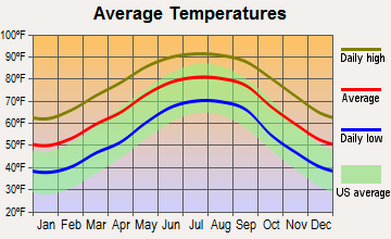
Average climate in Attapulgus, Georgia
Based on data reported by over 4,000 weather stations
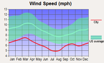


(lower is better)

Air Quality Index (AQI) level in 2022 was 70.0. This is about average.
| City: | 70.0 |
| U.S.: | 72.6 |

Ozone [ppb] level in 2022 was 22.7. This is significantly better than average. Closest monitor was 16.9 miles away from the city center.
| City: | 22.7 |
| U.S.: | 33.3 |

Particulate Matter (PM2.5) [µg/m3] level in 2022 was 9.24. This is about average. Closest monitor was 22.9 miles away from the city center.
| City: | 9.24 |
| U.S.: | 8.11 |
Tornado activity:
Attapulgus-area historical tornado activity is near Georgia state average. It is 30% greater than the overall U.S. average.
On 12/28/1968, a category F3 (max. wind speeds 158-206 mph) tornado 8.7 miles away from the Attapulgus city center caused between $5000 and $50,000 in damages.
On 2/13/2000, a category F3 tornado 25.2 miles away from the city center killed 6 people and injured 15 people and caused $5 million in damages.
Earthquake activity:
Attapulgus-area historical earthquake activity is above Georgia state average. It is 71% smaller than the overall U.S. average.On 9/10/2006 at 14:56:08, a magnitude 5.9 (5.9 MB, 5.5 MS, 5.8 MW, Class: Moderate, Intensity: VI - VII) earthquake occurred 337.4 miles away from Attapulgus center
On 10/24/1997 at 08:35:17, a magnitude 4.9 (4.8 MB, 4.2 MS, 4.9 LG, Depth: 6.2 mi, Class: Light, Intensity: IV - V) earthquake occurred 167.4 miles away from Attapulgus center
On 8/2/1974 at 08:52:09, a magnitude 4.9 (4.3 MB, 4.9 LG) earthquake occurred 245.5 miles away from Attapulgus center
On 1/18/1999 at 07:00:53, a magnitude 4.8 (4.8 MB, 4.0 LG, Depth: 0.6 mi) earthquake occurred 245.2 miles away from the city center
On 4/29/2003 at 08:59:39, a magnitude 4.9 (4.4 MB, 4.6 MW, 4.9 LG) earthquake occurred 267.5 miles away from the city center
On 4/29/2003 at 08:59:39, a magnitude 4.6 (4.6 MW, Depth: 12.3 mi) earthquake occurred 267.5 miles away from Attapulgus center
Magnitude types: regional Lg-wave magnitude (LG), body-wave magnitude (MB), surface-wave magnitude (MS), moment magnitude (MW)
Natural disasters:
The number of natural disasters in Decatur County (12) is smaller than the US average (15).Major Disasters (Presidential) Declared: 9
Emergencies Declared: 2
Causes of natural disasters: Floods: 6, Tornadoes: 5, Storms: 3, Heavy Rains: 2, Hurricanes: 2, Tropical Storms: 2, Winds: 2, Drought: 1, Other: 1 (Note: some incidents may be assigned to more than one category).

Hospitals and medical centers near Attapulgus:
- DECATUR COUNTY DIALYSIS CENTER (Dialysis Facility, about 12 miles away; BAINBRIDGE, GA)
- MEMORIAL HOSPITAL AND MANOR Acute Care Hospitals (about 12 miles away; BAINBRIDGE, GA)
- VNA OF SOUTHWEST GEORGIA INC (Home Health Center, about 12 miles away; BAINBRIDGE, GA)
- FLINT RIVER HOSPICE, INC (Hospital, about 12 miles away; BAINBRIDGE, GA)
- RCG - BAINBRIDGE (Dialysis Facility, about 12 miles away; BAINBRIDGE, GA)
- GENTIVA HEALTH SERVICES (Home Health Center, about 13 miles away; BAINBRIDGE, GA)
- WIREGRASS HOSPICE, BAINBRIDGE (Hospital, about 13 miles away; BAINBRIDGE, GA)
Airports located in Attapulgus:
- Viola Farm Airport (4GE1) (Runways: 1)
Colleges/universities with over 2000 students nearest to Attapulgus:
- Bainbridge State College (about 11 miles; Bainbridge, GA; Full-time enrollment: 2,308)
- Tallahassee Community College (about 23 miles; Tallahassee, FL; FT enrollment: 10,904)
- Florida State University (about 24 miles; Tallahassee, FL; FT enrollment: 38,283)
- Florida Agricultural and Mechanical University (about 26 miles; Tallahassee, FL; FT enrollment: 10,841)
- Albany Technical College (about 59 miles; Albany, GA; FT enrollment: 3,707)
- Darton State College (about 60 miles; Albany, GA; FT enrollment: 5,000)
- Albany State University (about 61 miles; Albany, GA; FT enrollment: 3,662)
Points of interest:
Notable location: Decatur County Fire and Rescue Station 230 (A). Display/hide its location on the map
Birthplace of: Hosea Williams - Recipient of the Purple Heart.
Drinking water stations with addresses in Attapulgus that have no violations reported:
- ATTAPULGUS (Population served: 825, Primary Water Source Type: Groundwater)
| This city: | 2.6 people |
| Georgia: | 2.6 people |
| This city: | 72.4% |
| Whole state: | 68.5% |
| This city: | 1.8% |
| Whole state: | 5.9% |
Likely homosexual households (counted as self-reported same-sex unmarried-partner households)
- Lesbian couples: 0.6% of all households
- Gay men: 0.0% of all households
For population 15 years and over in Attapulgus:

- Never married: 45.1%
- Now married: 29.9%
- Separated: 6.3%
- Widowed: 3.7%
- Divorced: 15.0%
For population 25 years and over in Attapulgus:
- High school or higher: 83.3%
- Bachelor's degree or higher: 3.7%
- Graduate or professional degree: 0.7%
- Unemployed: 8.9%
- Mean travel time to work (commute): 45.7 minutes


| Here: | 8.5 |
| Georgia average: | 12.2 |
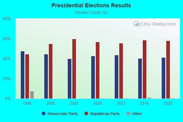
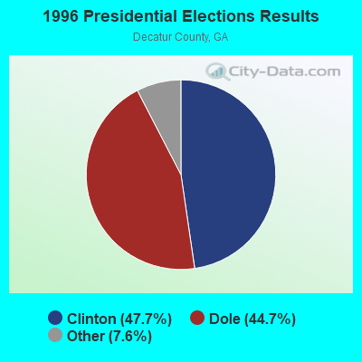
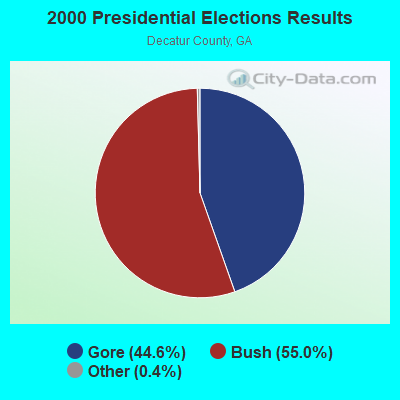
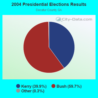
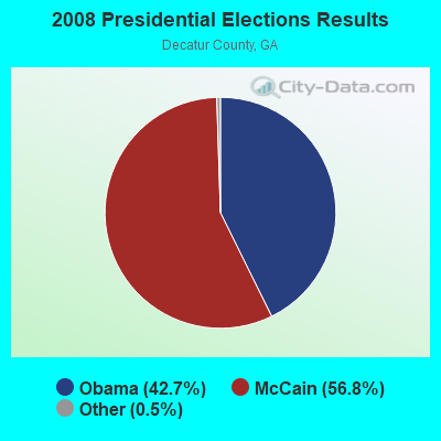
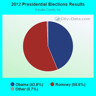

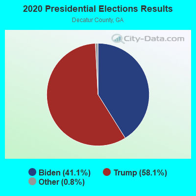
Graphs represent county-level data. Detailed 2008 Election Results
Religion statistics for Attapulgus, GA (based on Decatur County data)
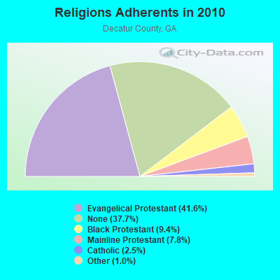
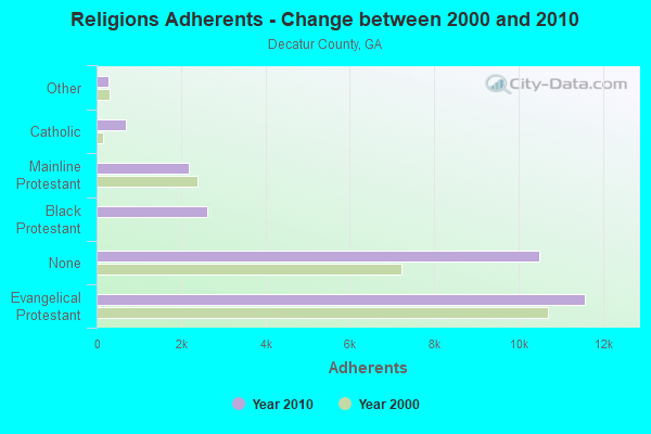
| Religion | Adherents | Congregations |
|---|---|---|
| Evangelical Protestant | 11,579 | 54 |
| Black Protestant | 2,610 | 17 |
| Mainline Protestant | 2,177 | 13 |
| Catholic | 699 | 1 |
| Other | 283 | 3 |
| None | 10,494 | - |
Food Environment Statistics:
| This county: | 3.15 / 10,000 pop. |
| Georgia: | 1.91 / 10,000 pop. |
| This county: | 0.35 / 10,000 pop. |
| Georgia: | 0.15 / 10,000 pop. |
| Decatur County: | 1.05 / 10,000 pop. |
| State: | 0.86 / 10,000 pop. |
| Decatur County: | 11.22 / 10,000 pop. |
| Georgia: | 5.12 / 10,000 pop. |
| This county: | 5.61 / 10,000 pop. |
| Georgia: | 7.41 / 10,000 pop. |
| Decatur County: | 11.8% |
| Georgia: | 10.4% |
| Decatur County: | 32.1% |
| Georgia: | 27.8% |
| Decatur County: | 12.6% |
| Georgia: | 14.6% |
Health and Nutrition:
| This city: | 45.9% |
| Georgia: | 48.9% |
| Attapulgus: | 41.7% |
| State: | 46.5% |
| Attapulgus: | 29.6 |
| Georgia: | 28.9 |
| Attapulgus: | 22.8% |
| State: | 20.4% |
| Attapulgus: | 12.4% |
| Georgia: | 10.8% |
| This city: | 6.8 |
| State: | 6.7 |
| Attapulgus: | 34.8% |
| Georgia: | 33.5% |
| This city: | 50.7% |
| Georgia: | 56.2% |
| Attapulgus: | 78.7% |
| Georgia: | 80.8% |
More about Health and Nutrition of Attapulgus, GA Residents
| Local government employment and payroll (March 2022) | |||||
| Function | Full-time employees | Monthly full-time payroll | Average yearly full-time wage | Part-time employees | Monthly part-time payroll |
|---|---|---|---|---|---|
| Financial Administration | 1 | $2,817 | $33,804 | 0 | $0 |
| Streets and Highways | 0 | $0 | 1 | $1,329 | |
| Other Government Administration | 0 | $0 | 5 | $612 | |
| Parks and Recreation | 0 | $0 | 1 | $929 | |
| Other and Unallocable | 0 | $0 | 1 | $233 | |
| Police Protection - Officers | 0 | $0 | 2 | $2,277 | |
| Solid Waste Management | 0 | $0 | 1 | $787 | |
| Water Supply | 0 | $0 | 3 | $1,511 | |
| Totals for Government | 1 | $2,817 | $33,804 | 14 | $7,677 |
Attapulgus government finances - Expenditure in 2017 (per resident):
- Construction - General Public Buildings: $12,000 ($26.79)
- Current Operations - Central Staff Services: $67,000 ($149.55)
Solid Waste Management: $56,000 ($125.00)
Police Protection: $39,000 ($87.05)
Regular Highways: $28,000 ($62.50)
Electric Utilities: $13,000 ($29.02)
General - Other: $13,000 ($29.02)
Judicial and Legal Services: $5,000 ($11.16)
Financial Administration: $3,000 ($6.70)
Gas Utilities: $2,000 ($4.46)
- Other Capital Outlay - Police Protection: $12,000 ($26.79)
Attapulgus government finances - Revenue in 2017 (per resident):
- Charges - Solid Waste Management: $39,000 ($87.05)
Sewerage: $21,000 ($46.88)
Other: $1,000 ($2.23)
- Local Intergovernmental - General Local Government Support: $96,000 ($214.29)
Other: $62,000 ($138.39)
- Miscellaneous - Fines and Forfeits: $7,000 ($15.62)
Sale of Property: $6,000 ($13.39)
Rents: $4,000 ($8.93)
Interest Earnings: $2,000 ($4.46)
- Revenue - Water Utilities: $32,000 ($71.43)
- Tax - Insurance Premiums Sales: $28,000 ($62.50)
Public Utilities Sales: $15,000 ($33.48)
Alcoholic Beverage Sales: $15,000 ($33.48)
Property: $8,000 ($17.86)
Occupation and Business License - Other: $2,000 ($4.46)
Attapulgus government finances - Cash and Securities in 2017 (per resident):
- Other Funds - Cash and Securities: $1,050,000 ($2343.75)
Strongest AM radio stations in Attapulgus:
- WSTT (730 AM; 25 kW; THOMASVILLE, GA; Owner: MARION R. WILLIAMS)
- WMGR (930 AM; 5 kW; BAINBRIDGE, GA; Owner: DECATUR BROADCASTING, INC.)
- WTCL (1580 AM; daytime; 10 kW; CHATTAHOOCHEE, FL; Owner: METZ, INC.)
- WFRF (1070 AM; daytime; 10 kW; TALLAHASSEE, FL; Owner: FAITH RADIO NETWORK, INC.)
- WHGH (840 AM; daytime; 10 kW; THOMASVILLE, GA; Owner: H. G. H INVESTMENT CORP.)
- WJEP (1020 AM; daytime; 10 kW; OCHLOCKNEE, GA; Owner: LIFELINE MINISTRIES, INCORPORATED)
- WCVC (1330 AM; daytime; 5 kW; TALLAHASSEE, FL)
- WHBT (1410 AM; 5 kW; TALLAHASSEE, FL)
- WNLS (1270 AM; 5 kW; TALLAHASSEE, FL; Owner: CLEAR CHANNEL BROADCASTING LICENSES, INC.)
- WFVR (910 AM; 50 kW; VALDOSTA, GA; Owner: RAMA COMMUNICATIONS, INC.)
- WWSD (1230 AM; 1 kW; QUINCY, FL; Owner: TUFF-STARR JAM COMMUNICATION, INC.)
- WGRA (790 AM; 1 kW; CAIRO, GA; Owner: LOVETT BROADCASTING ENTERPRISES, INC)
- WYBT (1000 AM; daytime; 5 kW; BLOUNTSTOWN, FL; Owner: BLOUNTSTOWN COMMUNICATIONS, INC.)
Strongest FM radio stations in Attapulgus:
- WWLD (102.3 FM; CAIRO, GA; Owner: CUMULUS LICENSING CORP.)
- WTNT-FM (94.9 FM; TALLAHASSEE, FL; Owner: CLEAR CHANNEL BROADCASTING LICENSES, INC.)
- WRAK-FM (97.3 FM; BAINBRIDGE, GA; Owner: CLEAR CHANNEL BROADCASTING LICENSES, INC.)
- WTLY (107.1 FM; THOMASVILLE, GA; Owner: CLEAR CHANNEL BROADCASTING LICENSES, INC.)
- WZND (105.3 FM; HEADLAND, AL; Owner: GULF SOUTH COMMUNICATIONS, INC.)
- WGWD (93.3 FM; GRETNA, FL; Owner: DE-COL INCORPORATED)
- WBWT (100.7 FM; MIDWAY, FL; Owner: CLEAR CHANNEL BROADCASTING LICENSES, INC.)
- WKVH (91.9 FM; MONTICELLO, FL; Owner: EDUCATIONAL MEDIA FOUNDATION)
- WBGE (101.9 FM; BAINBRIDGE, GA; Owner: JOHN H. WIGGINS)
- WHTF (104.9 FM; HAVANA, FL; Owner: MONTEREY LICENSES, LLC)
- WGLF (104.1 FM; TALLAHASSEE, FL; Owner: CUMULUS LICENSING CORP.)
- WFSU-FM (88.9 FM; TALLAHASSEE, FL; Owner: FLORIDA STATE UNIVERSITY)
- WBZE (98.9 FM; TALLAHASSEE, FL; Owner: CUMULUS LICENSING CORP.)
- WFSQ (91.5 FM; TALLAHASSEE, FL; Owner: FLORIDA STATE UNIVERSITY)
- WAIB (103.1 FM; TALLAHASSEE, FL; Owner: MONTEREY LICENSES, LLC)
- WXSR (101.5 FM; QUINCY, FL; Owner: CLEAR CHANNEL BROADCASTING LICENSES, INC.)
- WEGT (99.9 FM; LAFAYETTE, FL; Owner: MONTEREY LICENSES, LLC)
- WPAP-FM (92.5 FM; PANAMA CITY, FL; Owner: CLEAR CHANNEL BROADCASTING LICENSES, INC.)
- W250AF (97.9 FM; TALLAHASSEE, FL; Owner: TEMPLE BAPTIST CHURCH, INC.)
- W224AT (92.7 FM; TALLAHASSEE, FL; Owner: THE BD OF REGENTS OF FLORIDA STATE)
TV broadcast stations around Attapulgus:
- WTLH (Channel 49; BAINBRIDGE, GA; Owner: WTLH LICENSE CORP.)
- WTXL-TV (Channel 27; TALLAHASSEE, FL; Owner: MEDIA VENTURE MANAGEMENT, INC.)
- WTWC-TV (Channel 40; TALLAHASSEE, FL; Owner: WTWC LICENSEE, LLC)
- WCTV (Channel 6; THOMASVILLE, GA; Owner: WCTV LICENSEE CORP.)
- WVUP-CA (Channel 45; TALLAHASSEE, FL; Owner: CHRISTIAN TELEVISION CORPORATION, INC.)
- WTBC-LP (Channel 65; TALLAHASSEE, FL; Owner: TEMPLE BAPTIST CHURCH, INC.)
- WABW-TV (Channel 14; PELHAM, GA; Owner: GEORGIA PUBLIC TELECOMMUNICATIONS COMMISSION)
- WFSU-TV (Channel 11; TALLAHASSEE, FL; Owner: FLORIDA STATE UNIVERSITY)
- W35BN (Channel 35; TALLAHASSEE, FL; Owner: DEEPAK VISWANATH)
- WBXT-CA (Channel 56; TALLAHASSEE, FL; Owner: THE BOX WORLDWIDE LLC)
- W21BK (Channel 21; TALLAHASSEE, FL; Owner: JOSEPH W. SHAFFER)
- WWWF-LP (Channel 47; TALLAHASSEE, FL; Owner: TIGER EYE BROADCASTING CORPORATION)
Attapulgus fatal accident list:
Feb 24, 2016 08:26 AM, Sr-1, Lat: 30.742008, Lon: -84.462458, Vehicles: 2, Persons: 3, Fatalities: 1, Drunk persons involved: 1
Jun 26, 2015 03:50 PM, Us-27(Sr1), Attapulgus Climax Road, Lat: 30.777675, Lon: -84.489078, Vehicles: 2, Persons: 5, Fatalities: 1
Jun 27, 2015 04:02 AM, Sr-241, Lat: 30.724481, Lon: -84.486947, Vehicles: 1, Persons: 1, Fatalities: 1, Drunk persons involved: 1
Apr 6, 2011 11:15 PM, Sr-1, Lat: 30.765586, Lon: -84.474564, Vehicles: 3, Persons: 9, Fatalities: 5, Drunk persons involved: 1
Dec 20, 1996 06:23 PM, Sr1, Vehicles: 1, Persons: 3, Pedestrians: 1, Fatalities: 1
Oct 9, 1982 07:40 AM, 1, Vehicles: 1, Persons: 1, Fatalities: 1, Drunk persons involved: 1
- National Bridge Inventory (NBI) Statistics
- 7Number of bridges
- 95ft / 28.9mTotal length
- $5,550,000Total costs
- 12,580Total average daily traffic
- 2,603Total average daily truck traffic
- 18,870Total future (year 2032) average daily traffic
FCC Registered Cell Phone Towers:
1 (See the full list of FCC Registered Cell Phone Towers in Attapulgus)FCC Registered Antenna Towers:
39 (See the full list of FCC Registered Antenna Towers)FCC Registered Broadcast Land Mobile Towers:
3- 141 Engelhard Road (Lat: 30.743889 Lon: -84.500000), Type: Bant, Structure height: 30.5 m, Overall height: 33.5 m, Call Sign: WPRA567,
Assigned Frequencies: 451.625 MHz, 461.675 MHz, 462.200 MHz, 462.112 MHz, 464.612 MHz, Grant Date: 06/04/2015, Expiration Date: 07/25/2025, Certifier: Keith H Ansbacher, Registrant: Basf Corporation, 100 Park Avenue, Florham Park, NJ 07932, Phone: (973) 245-5351, Email:
- Engelhard Corp Plant (Lat: 30.744083 Lon: -84.499917), Call Sign: KFV675,
Assigned Frequencies: 49.5400 MHz, Grant Date: 11/01/2000, Expiration Date: 12/10/2005, Cancellation Date: 02/11/2006, Registrant: Porocel Corporation, 101 Wood Ave, Iselin, NJ 08830-0770, Phone: (908) 205-6087
- Lat: 30.745611 Lon: -84.501944, Call Sign: WPYM921,
Assigned Frequencies: 451.625 MHz, 456.625 MHz, Grant Date: 09/11/2003, Expiration Date: 09/11/2013, Cancellation Date: 08/09/2010, Certifier: Keith H Ansbacher, Registrant: Latham & Watkins LLP, 555 Eleventh Street, Nw, Suite 1000, Washington, DC 20004, Phone: (202) 637-2200, Fax: (202) 637-2201, Email:
FCC Registered Microwave Towers:
1- WATAUGA, 7106 Tallahassee Hwy (Ga12274-A) (Lat: 30.723194 Lon: -84.427111), Type: Tower, Structure height: 100.9 m, Overall height: 105.2 m, Call Sign: WQPS858,
Assigned Frequencies: 6004.50 MHz, Grant Date: 07/06/2022, Expiration Date: 08/07/2032, Certifier: Gregory M Romano, Registrant: Verizon, 5055 Northpointe Pkwy, Alpharetta, GA 30022, Phone: (770) 797-1070, Email:
FCC Registered Amateur Radio Licenses:
1- Call Sign: KK4KHA, Licensee ID: L01720106, Grant Date: 06/29/2012, Expiration Date: 06/29/2022, Certifier: Paul S Stewart, Registrant: Paul S Stewart, Attapulgus, GA 39815
2004 - 2018 National Fire Incident Reporting System (NFIRS) incidents
- Fire incident types reported to NFIRS in Attapulgus, GA
- 4646.0%Outside Fires
- 3232.0%Structure Fires
- 2121.0%Mobile Property/Vehicle Fires
- 11.0%Other
 Based on the data from the years 2004 - 2018 the average number of fire incidents per year is 7. The highest number of reported fires - 18 took place in 2017, and the least - 0 in 2014. The data has a growing trend.
 When looking into fire subcategories, the most incidents belonged to: Outside Fires (46.0%), and Structure Fires (32.0%).
| Most common first names in Attapulgus, GA among deceased individuals | ||
| Name | Count | Lived (average) |
|---|---|---|
| John | 18 | 73.1 years |
| James | 13 | 74.7 years |
| Mary | 13 | 73.1 years |
| William | 10 | 75.0 years |
| Robert | 7 | 73.3 years |
| Willie | 7 | 74.0 years |
| Hattie | 6 | 70.3 years |
| Charlie | 5 | 74.0 years |
| Annie | 5 | 70.2 years |
| Ethel | 5 | 68.2 years |
| Most common last names in Attapulgus, GA among deceased individuals | ||
| Last name | Count | Lived (average) |
|---|---|---|
| Spooner | 13 | 74.8 years |
| Taylor | 11 | 73.8 years |
| Miller | 11 | 55.7 years |
| Strickland | 9 | 68.8 years |
| Smith | 9 | 69.0 years |
| Bouie | 8 | 76.9 years |
| Johnson | 8 | 70.5 years |
| Harris | 8 | 69.0 years |
| Scott | 7 | 68.6 years |
| White | 7 | 73.9 years |

- 83.2%Electricity
- 13.0%Bottled, tank, or LP gas
- 1.5%Fuel oil, kerosene, etc.
- 1.5%No fuel used
- 0.8%Utility gas
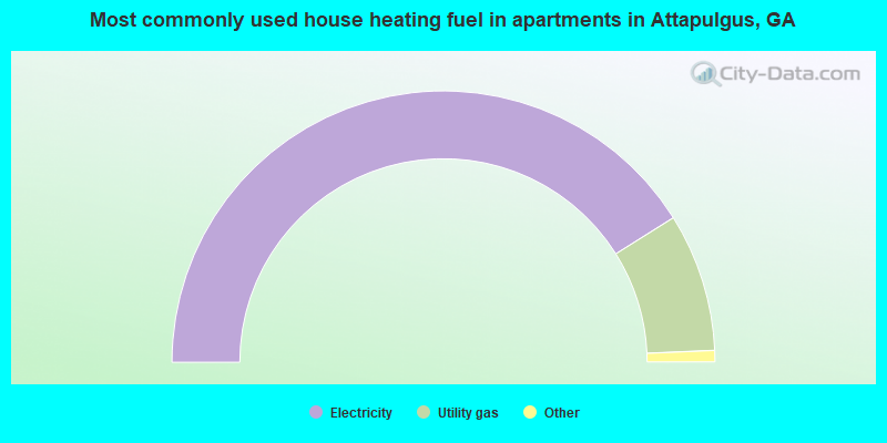
- 87.9%Electricity
- 12.1%Utility gas
Attapulgus compared to Georgia state average:
- Median household income below state average.
- Median house value significantly below state average.
- Unemployed percentage below state average.
- Black race population percentage above state average.
- Hispanic race population percentage significantly above state average.
- Length of stay since moving in significantly above state average.
- House age above state average.
- Number of college students significantly below state average.
- Percentage of population with a bachelor's degree or higher significantly below state average.