Ashport-Three Point, Tennessee
Submit your own pictures of this place and show them to the world
- OSM Map
- Google Map
- MSN Map
| Males: 3,061 | |
| Females: 755 |
| Median resident age: | 33.6 years |
| Tennessee median age: | 35.9 years |
Zip code: 38063
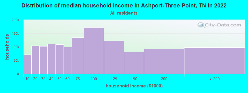
| Ashport-Three Point: | $53,201 |
| TN: | $65,254 |
Estimated per capita income in 2022: $15,580 (it was $8,593 in 2000)
Ashport-Three Point CCD income, earnings, and wages data
Estimated median house or condo value in 2022: $121,918 (it was $52,100 in 2000)
| Ashport-Three Point: | $121,918 |
| TN: | $284,800 |
Ashport-Three Point, TN residents, houses, and apartments details
Detailed information about poverty and poor residents in Ashport-Three Point, TN


- 1,93149.7%White alone
- 1,84547.5%Black alone
- 471.2%Hispanic
- 381.0%Two or more races
- 150.4%American Indian alone
- 30.08%Asian alone
- 30.08%Native Hawaiian and Other
Pacific Islander alone - 10.03%Other race alone

Races in Ashport-Three Point detailed stats: ancestries, foreign born residents, place of birth
 Recent articles from our blog. Our writers, many of them Ph.D. graduates or candidates, create easy-to-read articles on a wide variety of topics.
Current Local Time: CST time zone
Land area: 200.1 square miles.
Population density: 19 people per square mile (very low).
| Ashport-Three Point CCD: | 0.6% ($318) |
| Tennessee: | 0.8% ($715) |
Nearest city with pop. 50,000+: Memphis, TN  (44.9 miles , pop. 650,100).
Nearest city with pop. 1,000,000+: Chicago, IL (436.4 miles , pop. 2,896,016).
Nearest cities:
), ), ), Latitude: 35.74 N, Longitude: 89.76 W
| Here: | 4.7% |
| Tennessee: | 3.0% |

- Public administration (11.1%)
- Health care (9.7%)
- Metal & metal products (7.8%)
- Construction (7.7%)
- Agriculture, forestry, fishing & hunting (7.4%)
- Accommodation & food services (5.2%)
- Transportation equipment (4.4%)

- Construction (13.7%)
- Agriculture, forestry, fishing & hunting (11.7%)
- Public administration (10.0%)
- Metal & metal products (9.5%)
- Motor vehicle & parts dealers (5.6%)
- Food & beverage stores (4.6%)
- Chemicals (3.7%)

- Health care (20.4%)
- Public administration (12.4%)
- Accommodation & food services (9.0%)
- Transportation equipment (6.2%)
- Apparel (6.2%)
- Metal & metal products (5.6%)
- Electrical equipment, appliances, components (5.3%)

- Other production occupations, including supervisors (8.1%)
- Electrical equipment mechanics and other installation, maintenance, and repair workers, including supervisors (6.0%)
- Secretaries and administrative assistants (5.1%)
- Vehicle and mobile equipment mechanics, installers, and repairers (4.8%)
- Bookkeeping, accounting, and auditing clerks (4.1%)
- Nursing, psychiatric, and home health aides (4.0%)
- Waiters and waitresses (4.0%)

- Electrical equipment mechanics and other installation, maintenance, and repair workers, including supervisors (9.5%)
- Law enforcement workers, including supervisors (6.8%)
- Other material moving workers, except laborers (5.9%)
- Farmers and farm managers (5.6%)
- Vehicle and mobile equipment mechanics, installers, and repairers (5.6%)
- Agricultural workers, including supervisors (5.1%)
- Other production occupations, including supervisors (5.1%)

- Other production occupations, including supervisors (11.8%)
- Secretaries and administrative assistants (11.5%)
- Nursing, psychiatric, and home health aides (9.0%)
- Waiters and waitresses (9.0%)
- Bookkeeping, accounting, and auditing clerks (5.3%)
- Other management occupations, except farmers and farm managers (5.0%)
- Metal workers and plastic workers (5.0%)
Average climate in Ashport-Three Point, Tennessee
Based on data reported by over 4,000 weather stations


Tornado activity:
Ashport-Three Point-area historical tornado activity is above Tennessee state average. It is 114% greater than the overall U.S. average.
On 3/1/1997, a category F4 (max. wind speeds 207-260 mph) tornado 14.5 miles away from the Ashport-Three Point place center caused $30,000 in damages.
On 3/1/1997, a category F4 tornado 15.2 miles away from the place center injured 15 people and caused $2 million in damages.
Earthquake activity:
Ashport-Three Point-area historical earthquake activity is significantly above Tennessee state average. It is 398% greater than the overall U.S. average.On 3/25/1976 at 00:41:20, a magnitude 5.0 (4.9 MB, 5.0 LG, Class: Moderate, Intensity: VI - VII) earthquake occurred 32.6 miles away from the city center
On 5/4/1991 at 01:18:54, a magnitude 5.0 (4.4 MB, 4.6 LG, 5.0 LG, Depth: 3.1 mi) earthquake occurred 56.9 miles away from Ashport-Three Point center
On 4/27/1989 at 16:47:49, a magnitude 4.7 (4.6 MB, 4.7 LG, 4.3 LG, Class: Light, Intensity: IV - V) earthquake occurred 18.2 miles away from the city center
On 9/26/1990 at 13:18:51, a magnitude 5.0 (4.7 MB, 4.8 LG, 5.0 LG, Depth: 7.7 mi) earthquake occurred 99.3 miles away from the city center
On 4/18/2008 at 09:36:59, a magnitude 5.4 (5.1 MB, 4.8 MS, 5.4 MW, 5.2 MW) earthquake occurred 214.0 miles away from Ashport-Three Point center
On 3/25/1976 at 01:00:11, a magnitude 4.5 (4.1 MB, 4.5 LG) earthquake occurred 41.4 miles away from the city center
Magnitude types: regional Lg-wave magnitude (LG), body-wave magnitude (MB), surface-wave magnitude (MS), moment magnitude (MW)
Natural disasters:
The number of natural disasters in Lauderdale County (17) is near the US average (15).Major Disasters (Presidential) Declared: 14
Emergencies Declared: 1
Causes of natural disasters: Storms: 13, Floods: 12, Tornadoes: 7, Winds: 3, Flash Flood: 1, Hurricane: 1, Ice Storm: 1, Landslide: 1, Mudslide: 1, Winter Storm: 1, Other: 1 (Note: some incidents may be assigned to more than one category).
Hospitals and medical centers near Ashport-Three Point:
- (CLOSED) BAPTIST MEMORIAL HOSPITAL LAUDERDALE (Hospital, about 12 miles away; RIPLEY, TN)
- LAUDERDALE COMMUNITY HOSPITAL Critical Access Hospitals (about 12 miles away; RIPLEY, TN)
- OSCEOLA NURSING HOME (Nursing Home, about 12 miles away; OSCEOLA, AR)
- HILLHAVEN CONVALESCENT RIPLEY (Nursing Home, about 13 miles away; RIPLEY, TN)
- SOUTH MISSISSISSPI COUNTY REGIONAL MEDICAL CENTER Critical Access Hospitals (about 13 miles away; OSCEOLA, AR)
- BAPTIST MEMORIAL HOME CARE OSCEOLA (Hospital, about 13 miles away; OSCEOLA, AR)
- LAUDERDALE COMM LIVING CTR (Nursing Home, about 13 miles away; RIPLEY, TN)
Colleges/universities with over 2000 students nearest to Ashport-Three Point:
- Dyersburg State Community College (about 30 miles; Dyersburg, TN; Full-time enrollment: 2,211)
- Rhodes College (about 43 miles; Memphis, TN; FT enrollment: 2,052)
- Southwest Tennessee Community College (about 45 miles; Memphis, TN; FT enrollment: 8,043)
- University of Memphis (about 46 miles; Memphis, TN; FT enrollment: 17,427)
- Union University (about 51 miles; Jackson, TN; FT enrollment: 4,051)
- Arkansas State University-Main Campus (about 53 miles; Jonesboro, AR; FT enrollment: 12,323)
- Jackson State Community College (about 56 miles; Jackson, TN; FT enrollment: 2,958)
Points of interest:
Notable locations in Ashport-Three Point: Fort Pillow State Farm (A), Barr Landing (B), Fort Pillow Landing (C), Gold Dust Landing (D), Goses Landing (E), Head of Island Number Thirtyfour Landing (F), Heffner Landing (G), Keyes Point Landing (H), Litler Landing (I), Lookout Landing (J), Nebraska Landing (K), Plum Point Landing (L), Saw Mill Landing (M), Tamm Landing (N), Wardlows Pocket Landing (O), Ashport Landing (P), Daniels Point Landing (Q), Lower Forked Deer Landing (R). Display/hide their locations on the map
Churches in Ashport-Three Point include: Pilgrims Rest Church (A), Hales Point Church (B), Golddust Church (C), Fulton Baptist Church (D), Bethel Church (E), Saint James Church (F), Luckett Church (G), El Canaan Church (H), Pilgrim Rest Church (I). Display/hide their locations on the map
Cemeteries: Samuels Cemetery (1), Bates Cemetery (2), Western Valley Cemetery (3), Saint James Cemetery (4), Elcanaan Cemetery (5), New Hope Cemetery (6), Green Cemetery (7). Display/hide their locations on the map
Lakes, reservoirs, and swamps: Champion Lake (A), Goose Pond (B), Lost Lake (C), Sunk Lake (D), Johnson Lake (E), Camp Slough (F), Little Mud Lake (G), Bee Lake (H). Display/hide their locations on the map
Streams, rivers, and creeks: Lower Forked Deer River (A), Knob Creek (B), Jones Slough (C), Cotton Slough (D), Cane Creek (E), Hatchie River (F), Boar Creek (G), Ash Bayou (H), Adams Bayou (I). Display/hide their locations on the map
Parks in Ashport-Three Point include: Lower Hatchie National Wildlife Refuge (1), Chickasaw National Wildlife Refuge (2), Fort Pillow State Park (3), Anderson-Tully State Wildlife Management Area (4), Fort Pillow State Historic Area (5). Display/hide their locations on the map
| This place: | 2.5 people |
| Tennessee: | 2.5 people |
| This place: | 50.9% |
| Whole state: | 69.8% |
| This place: | 5.2% |
| Whole state: | 4.2% |
Likely homosexual households (counted as self-reported same-sex unmarried-partner households)
- Lesbian couples: 0.2% of all households
- Gay men: 0.3% of all households
| This place: | 12.2% |
| Whole state: | 13.5% |
| This place: | 6.2% |
| Whole state: | 5.8% |
For population 15 years and over in Ashport-Three Point:

- Never married: 42.4%
- Now married: 41.3%
- Separated: 4.3%
- Widowed: 3.2%
- Divorced: 13.0%
For population 25 years and over in Ashport-Three Point:
- High school or higher: 58.7%
- Bachelor's degree or higher: 3.6%
- Graduate or professional degree: 1.0%
- Unemployed: 4.9%
- Mean travel time to work (commute): 29.5 minutes


| Here: | 11.2 |
| Tennessee average: | 13.3 |
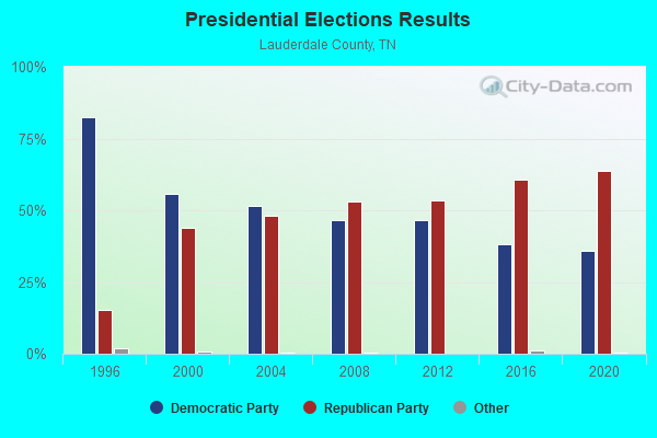

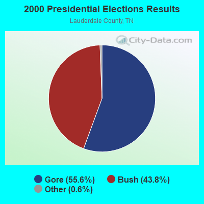


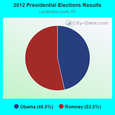


Graphs represent county-level data. Detailed 2008 Election Results
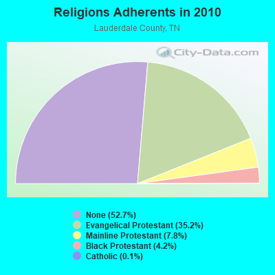
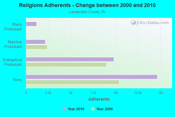
Religion statistics for Ashport-Three Point, TN (based on Lauderdale County data)
| Religion | Adherents | Congregations |
|---|---|---|
| Evangelical Protestant | 9,791 | 51 |
| Mainline Protestant | 2,156 | 21 |
| Black Protestant | 1,164 | 6 |
| Catholic | 34 | 1 |
| Other | 2 | 1 |
| None | 14,668 | - |
Food Environment Statistics:
| Lauderdale County: | 3.00 / 10,000 pop. |
| Tennessee: | 1.99 / 10,000 pop. |
| This county: | 0.37 / 10,000 pop. |
| State: | 0.17 / 10,000 pop. |
| Lauderdale County: | 0.37 / 10,000 pop. |
| Tennessee: | 0.65 / 10,000 pop. |
| Lauderdale County: | 6.00 / 10,000 pop. |
| State: | 5.16 / 10,000 pop. |
| Here: | 2.62 / 10,000 pop. |
| State: | 6.56 / 10,000 pop. |
| This county: | 11.3% |
| Tennessee: | 11.4% |
| Lauderdale County: | 34.9% |
| Tennessee: | 30.2% |
| This county: | 12.4% |
| State: | 13.5% |
Strongest AM radio stations in Ashport-Three Point:
- WDIA (1070 AM; 50 kW; MEMPHIS, TN; Owner: CLEAR CHANNEL BROADCASTING LICENSES, INC.)
- WGSF (1030 AM; 50 kW; MEMPHIS, TN; Owner: FLINN BROADCASTING CORPORATION)
- KLCN (910 AM; 5 kW; BLYTHEVILLE, AR; Owner: SUDBURY SERVICES, INC.)
- WCRV (640 AM; 50 kW; COLLIERVILLE, TN; Owner: BOTT BROADCASTING COMPANY/TENNESSEE)
- WMQM (1600 AM; 50 kW; LAKELAND, TN; Owner: WMQM, INC.)
- WJCE (680 AM; 10 kW; MEMPHIS, TN; Owner: ENTERCOM MEMPHIS LICENSE, LLC)
- KOTC (830 AM; daytime; 10 kW; KENNETT, MO; Owner: EAGLE BLUFF ENTERPRISES)
- KOSE (860 AM; 1 kW; WILSON, AR; Owner: NEWPORT BROADCASTING COMPANY)
- KWAM (990 AM; 10 kW; MEMPHIS, TN; Owner: CONCORD MEDIA GROUP, INC.)
- WHBQ (560 AM; 5 kW; MEMPHIS, TN; Owner: FLINN BROADCASTING CORPORATION)
- WREC (600 AM; 5 kW; MEMPHIS, TN; Owner: CLEAR CHANNEL BROADCASTING LICENSES, INC.)
- WTRB (1570 AM; 1 kW; RIPLEY, TN; Owner: WILLIAMS COMMUNICATIONS, INC.)
- WKBL (1250 AM; 1 kW; COVINGTON, TN; Owner: COVINGTON BROADCASTING, INC.)
Strongest FM radio stations in Ashport-Three Point:
- KQDD (107.3 FM; OSCEOLA, AR; Owner: PHOENIX BROADCASTING GROUP, INC.)
- KAMJ (93.9 FM; GOSNELL, AR; Owner: PHOENIX BROADCASTING GROUP, INC.)
- KHLS (96.3 FM; BLYTHEVILLE, AR; Owner: SUDBURY SERVICES, INC.)
- WYPL (89.3 FM; MEMPHIS, TN; Owner: MEMPHIS/SHELBY COUNTY PUBLIC LIBRARY & INFO CNTR.)
- WKBQ (93.5 FM; COVINGTON, TN; Owner: COVINGTON BROADCASTING, INC.)
- WJZN (98.9 FM; MUNFORD, TN; Owner: MEMPHIS III LIMITED PARTNERSHIP)
- WAPO (90.5 FM; MOUNT VERNON, IL; Owner: AMERICAN FAMILY ASSOCIATION)
- WAUV (89.7 FM; RIPLEY, TN; Owner: AMERICAN FAMILY ASSOCIATION)
- WEGR (102.7 FM; MEMPHIS, TN; Owner: CLEAR CHANNEL BROADCASTING LICENSES, INC.)
- WSRR-FM (98.1 FM; MILLINGTON, TN; Owner: KOOL BROADCASTING, INC.)
- WKVZ (94.9 FM; RIPLEY, TN; Owner: EDUCATIONAL MEDIA FOUNDATION)
- WASL (100.1 FM; DYERSBURG, TN; Owner: DR PEPPER PEPSI-COLA BOTTLING CO.)
- WGKX (105.9 FM; MEMPHIS, TN; Owner: KIX BROADCASTING, INC.)
- WRVR-FM (104.5 FM; MEMPHIS, TN; Owner: ENTERCOM MEMPHIS LICENSE, LLC)
- WMC-FM (99.7 FM; MEMPHIS, TN; Owner: INFINITY RADIO OPERATIONS INC.)
- WKNQ (90.7 FM; DYERSBURG, TN; Owner: MID-SOUTH PUBLIC COMMS. FOUNDATION)
- KBCM (88.3 FM; BLYTHEVILLE, AR; Owner: AMERICAN FAMILY ASSOCIATION)
- W205BN (88.9 FM; DYERSBURG, TN; Owner: WAY-FM MEDIA GROUP, INC.)
TV broadcast stations around Ashport-Three Point:
- WMC-TV (Channel 5; MEMPHIS, TN; Owner: RAYCOM AMERICA, INC.)
- WLMT (Channel 30; MEMPHIS, TN; Owner: CLEAR CHANNEL BROADCASTING LICENSES, INC.)
- WPTY-TV (Channel 24; MEMPHIS, TN; Owner: CLEAR CHANNEL BROADCASTING LICENSES, INC.)
- WREG-TV (Channel 3; MEMPHIS, TN; Owner: NEW YORK TIMES MANAGEMENT SERVICES)
- WPXX-TV (Channel 50; MEMPHIS, TN; Owner: FLINN BROADCASTING CORPORATION)
- WJKT (Channel 16; JACKSON, TN; Owner: CLEAR CHANNEL BROADCASTING LICENSES, INC.)
- WHBQ-TV (Channel 13; MEMPHIS, TN; Owner: FOX TELEVISION STATIONS, INC.)
- WKNO (Channel 10; MEMPHIS, TN; Owner: MID-SOUTH PUBLIC COMMUNICATIONS FOUNDATION)
- KVTJ (Channel 48; JONESBORO, AR; Owner: AGAPE CHURCH, INC.)
- WDYR-CA (Channel 33; DYERSBURG, TN; Owner: TRI-STATE CHRISTIAN TV, INC.)
- W67CV (Channel 67; MEMPHIS, TN; Owner: GEORGE S. FLINN, JR.)
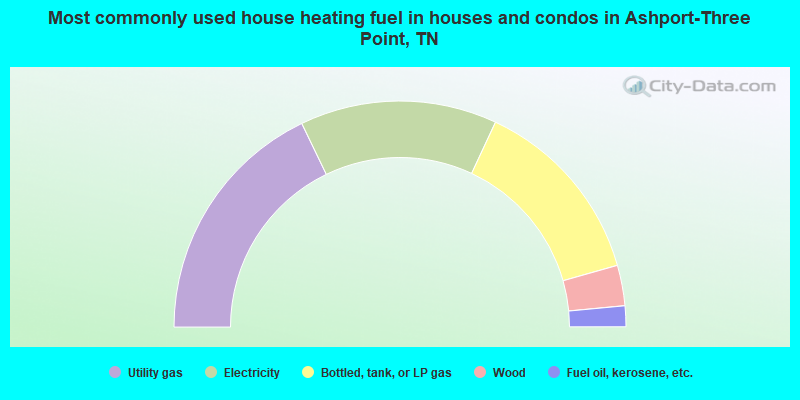
- 35.7%Utility gas
- 28.2%Electricity
- 27.3%Bottled, tank, or LP gas
- 5.8%Wood
- 3.0%Fuel oil, kerosene, etc.
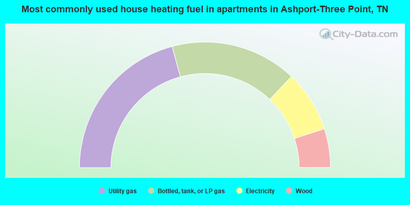
- 41.6%Utility gas
- 32.6%Bottled, tank, or LP gas
- 15.8%Electricity
- 10.0%Wood
Ashport-Three Point compared to Tennessee state average:
- Median house value significantly below state average.
- Unemployed percentage below state average.
- Black race population percentage significantly above state average.
- Hispanic race population percentage significantly below state average.
- Median age below state average.
- Foreign-born population percentage significantly below state average.
- Renting percentage significantly below state average.
- Length of stay since moving in significantly above state average.
- Number of rooms per house significantly below state average.
- House age significantly below state average.
- Institutionalized population percentage significantly above state average.
- Percentage of population with a bachelor's degree or higher significantly below state average.
Ashport-Three Point on our top lists:
- #15 on the list of "Top 101 cities with the largest percentage of people in state prisons (population 1,000+)"