Ashfork, Arizona
Submit your own pictures of this place and show them to the world
- OSM Map
- General Map
- Google Map
- MSN Map

| Males: 1,262 | |
| Females: 1,111 |
| Median resident age: | 41.7 years |
| Arizona median age: | 34.2 years |
Zip code: 86337
| Ashfork: | $43,014 |
| AZ: | $74,568 |
Estimated per capita income in 2022: $23,535 (it was $11,804 in 2000)
Ashfork CCD income, earnings, and wages data
Estimated median house or condo value in 2022: $178,125 (it was $47,000 in 2000)
| Ashfork: | $178,125 |
| AZ: | $402,800 |
Mean prices in 2022: all housing units: $497,398; detached houses: $554,279; townhouses or other attached units: $444,806; in 2-unit structures: $963,710; in 3-to-4-unit structures: $330,793; in 5-or-more-unit structures: $347,956; mobile homes: $254,882; occupied boats, rvs, vans, etc.: $22,781
Detailed information about poverty and poor residents in Ashfork, AZ


- 1,38973.5%White alone
- 40821.6%Hispanic
- 432.3%Two or more races
- 221.2%Black alone
- 191.0%American Indian alone
- 70.4%Asian alone
- 30.2%Native Hawaiian and Other
Pacific Islander alone

According to our research of Arizona and other state lists, there was 1 registered sex offender living in Ashfork, Arizona as of May 22, 2024.
The ratio of all residents to sex offenders in Ashfork is 2,373 to 1.
The ratio of registered sex offenders to all residents in this city is much lower than the state average.
 Recent articles from our blog. Our writers, many of them Ph.D. graduates or candidates, create easy-to-read articles on a wide variety of topics.
Current Local Time: MST (no DST) time zone
Land area: 1522.5 square miles.
Population density: 1.6 people per square mile (very low).

| Ashfork CCD: | 0.7% ($347) |
| Arizona: | 0.9% ($962) |
Nearest city with pop. 50,000+: Flagstaff, AZ  (71.7 miles , pop. 52,894).
Nearest city with pop. 200,000+: Glendale, AZ (122.8 miles , pop. 218,812).
Nearest city with pop. 1,000,000+: Phoenix, AZ (128.6 miles , pop. 1,321,045).
Nearest cities:
Latitude: 35.26 N, Longitude: 112.90 W
Area code commonly used in this area: 928


| Here: | 3.3% |
| Arizona: | 3.8% |

- Accommodation & food services (19.5%)
- Mining, quarrying, oil & gas extraction (14.3%)
- Educational services (9.1%)
- Construction (8.7%)
- Public administration (7.4%)
- Agriculture, forestry, fishing & hunting (5.9%)
- Gasoline stations (5.7%)

- Mining, quarrying, oil & gas extraction (23.0%)
- Construction (14.3%)
- Accommodation & food services (9.2%)
- Agriculture, forestry, fishing & hunting (8.7%)
- Public administration (6.9%)
- Educational services (4.7%)
- Gasoline stations (4.2%)

- Accommodation & food services (35.7%)
- Educational services (16.1%)
- Gasoline stations (8.0%)
- Public administration (8.0%)
- Real estate & rental & leasing (5.2%)
- Health care (4.9%)
- Food & beverage stores (3.1%)

- Other sales and related occupations, including supervisors (7.1%)
- Building and grounds cleaning and maintenance occupations (6.9%)
- Extraction workers (6.7%)
- Cooks and food preparation workers (5.4%)
- Cashiers (5.3%)
- Preschool, kindergarten, elementary, and middle school teachers (4.9%)
- Other management occupations, except farmers and farm managers (4.8%)

- Extraction workers (10.5%)
- Building and grounds cleaning and maintenance occupations (8.3%)
- Electrical equipment mechanics and other installation, maintenance, and repair workers, including supervisors (5.6%)
- Driver/sales workers and truck drivers (5.6%)
- Other management occupations, except farmers and farm managers (5.4%)
- Other material moving workers, except laborers (5.4%)
- Agricultural workers, including supervisors (5.4%)

- Other sales and related occupations, including supervisors (10.5%)
- Cooks and food preparation workers (10.1%)
- Waiters and waitresses (8.7%)
- Preschool, kindergarten, elementary, and middle school teachers (8.4%)
- Other office and administrative support workers, including supervisors (7.7%)
- Information and record clerks, except customer service representatives (7.3%)
- Cashiers (7.3%)
Average climate in Ashfork, Arizona
Based on data reported by over 4,000 weather stations


Earthquake activity:
Ashfork-area historical earthquake activity is significantly above Arizona state average. It is 3455% greater than the overall U.S. average.On 6/28/1992 at 11:57:34, a magnitude 7.6 (6.2 MB, 7.6 MS, 7.3 MW, Depth: 0.7 mi, Class: Major, Intensity: VIII - XII) earthquake occurred 219.5 miles away from the city center, causing 3 deaths (1 shaking deaths, 2 other deaths) and 400 injuries, causing $100,000,000 total damage and $40,000,000 insured losses
On 10/16/1999 at 09:46:44, a magnitude 7.4 (6.3 MB, 7.4 MS, 7.2 MW, 7.3 ML) earthquake occurred 207.1 miles away from Ashfork center
On 5/19/1940 at 04:36:40, a magnitude 7.2 (7.2 UK) earthquake occurred 213.2 miles away from the city center, causing $33,000,000 total damage
On 7/21/1952 at 11:52:14, a magnitude 7.7 (7.7 UK) earthquake occurred 345.6 miles away from the city center, causing $50,000,000 total damage
On 12/31/1934 at 18:45:56, a magnitude 7.1 (7.1 UK) earthquake occurred 242.2 miles away from Ashfork center
On 10/15/1979 at 23:16:54, a magnitude 7.0 (5.7 MB, 6.9 MS, 7.0 ML, 6.4 MW) earthquake occurred 230.8 miles away from the city center
Magnitude types: body-wave magnitude (MB), local magnitude (ML), surface-wave magnitude (MS), moment magnitude (MW)
Natural disasters:
The number of natural disasters in Yavapai County (18) is near the US average (15).Major Disasters (Presidential) Declared: 9
Emergencies Declared: 2
Causes of natural disasters: Floods: 9, Storms: 8, Fires: 6, Drought: 1, Hurricane: 1, Tornado: 1, Winter Storm: 1, Other: 1 (Note: some incidents may be assigned to more than one category).
Colleges/universities with over 2000 students nearest to Ashfork:
- Yavapai College (about 56 miles; Prescott, AZ; Full-time enrollment: 4,258)
- Northcentral University (about 58 miles; Prescott Valley, AZ; FT enrollment: 5,927)
- Mohave Community College (about 64 miles; Kingman, AZ; FT enrollment: 3,309)
- Northern Arizona University (about 71 miles; Flagstaff, AZ; FT enrollment: 22,494)
- Coconino Community College (about 72 miles; Flagstaff, AZ; FT enrollment: 2,090)
- Universal Technical Institute of Arizona Inc-Motorcycle Mechanics Institute Division (about 118 miles; Phoenix, AZ; FT enrollment: 2,976)
- Arizona State University-West (about 122 miles; Glendale, AZ; FT enrollment: 3,454)
Public schools in Ashfork:
- ASH FORK ELEMENTARY SCHOOL (Students: 135, Location: 46999 N. FIFTH STREET)
- ASH FORK HIGH SCHOOL (Students: 100, Location: 46999 N. FIFTH STREET)
- ASH FORK MIDDLE SCHOOL (Students: 76, Location: 46999 N. FIFTH STREET)
- MIJTED - ASHFORK HIGH SCHOOL (Location: 46999 N 5TH STREET)
Points of interest:
Notable locations in Ashfork: Cowden Ranch (A), Double O Ranch (B), Ash Fork Substation (C), Camp Cotton (D), E L Camp (E), H-Ranch (F), New Water Line Camp (G), Pollocks Substation (H), Rok Siding (I), Chino Station (J), Arizona Highway Maintenance Yard (K), Seligman Compressor Station (L), Cruice Siding (M), Wood Spur Siding (N), Prairie Siding (O), Meath Siding (P), Yavapai Ranch (Q), Anvil Rock Ranch (R), Bear Creek Camp (S), Dennys Ranch (T). Display/hide their locations on the map
Church in Ashfork: First Southern Baptist Church (A). Display/hide its location on the map
Cemeteries: Nelson Cemetery (1), Ash Fork Cemetery (2). Display/hide their locations on the map
Lakes and reservoirs: Meadow Lake (A), Red Lake (B), Lindberg Tank (C), Limestone Tank (D), Wood Camp Tank (E), Barrata (F), Bass Pond Tank (G), Bean Dam Tank (H). Display/hide their locations on the map
Streams, rivers, and creeks: Bear Creek (A), Pineveta Wash (B), Meath Wash (C), Muddy Creek (D), Muddy Wash (E), Francis Creek (F), Hop Creek (G), Fork Rock Creek (H), Partridge Creek (I). Display/hide their locations on the map
| This place: | 2.1 people |
| Arizona: | 2.6 people |
| This place: | 58.0% |
| Whole state: | 66.2% |
| This place: | 7.4% |
| Whole state: | 7.8% |
Likely homosexual households (counted as self-reported same-sex unmarried-partner households)
- Lesbian couples: 0.9% of all households
- Gay men: 0.1% of all households
| This place: | 21.1% |
| Whole state: | 13.9% |
| This place: | 7.9% |
| Whole state: | 6.2% |
For population 15 years and over in Ashfork:

- Never married: 19.5%
- Now married: 62.1%
- Separated: 1.9%
- Widowed: 5.3%
- Divorced: 13.0%
For population 25 years and over in Ashfork:
- High school or higher: 76.8%
- Bachelor's degree or higher: 14.8%
- Graduate or professional degree: 4.2%
- Unemployed: 10.4%
- Mean travel time to work (commute): 26.5 minutes


| Here: | 12.9 |
| Arizona average: | 13.1 |
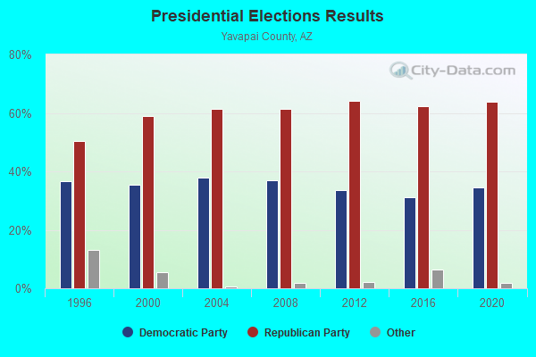
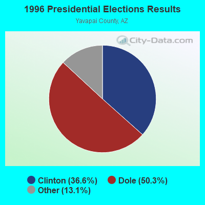
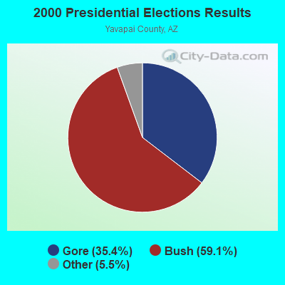
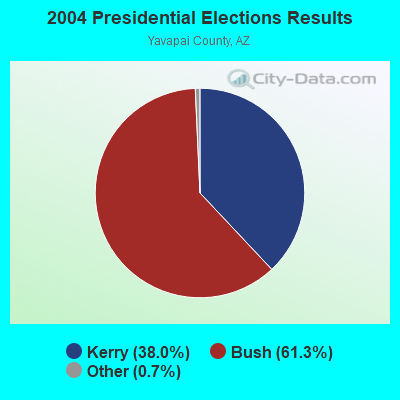
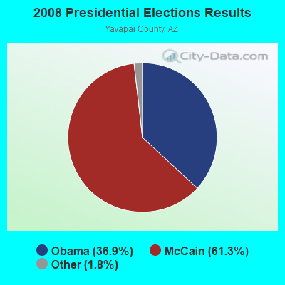

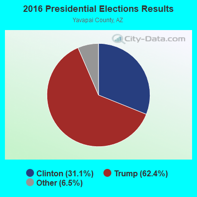
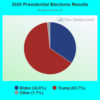
Graphs represent county-level data. Detailed 2008 Election Results
Religion statistics for Ashfork, AZ (based on Yavapai County data)
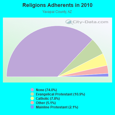
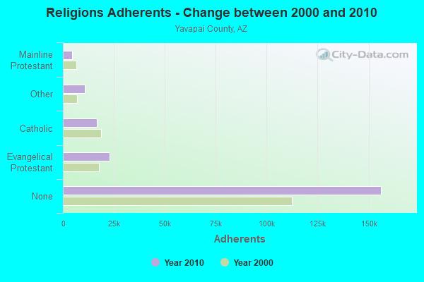
| Religion | Adherents | Congregations |
|---|---|---|
| Evangelical Protestant | 22,957 | 156 |
| Catholic | 16,500 | 14 |
| Other | 10,740 | 47 |
| Mainline Protestant | 4,525 | 22 |
| Orthodox | 100 | 1 |
| None | 156,211 | - |
Food Environment Statistics:
| Yavapai County: | 1.93 / 10,000 pop. |
| Arizona: | 1.36 / 10,000 pop. |
| This county: | 0.14 / 10,000 pop. |
| State: | 0.14 / 10,000 pop. |
| Yavapai County: | 0.57 / 10,000 pop. |
| Arizona: | 0.55 / 10,000 pop. |
| Yavapai County: | 3.25 / 10,000 pop. |
| State: | 2.47 / 10,000 pop. |
| Here: | 10.18 / 10,000 pop. |
| State: | 6.21 / 10,000 pop. |
| This county: | 7.5% |
| Arizona: | 8.0% |
| Yavapai County: | 17.7% |
| Arizona: | 22.8% |
| This county: | 10.4% |
| State: | 14.2% |
Strongest AM radio stations in Ashfork:
- KMIA (710 AM; 50 kW; BLACK CANYON CITY, AZ; Owner: ENTRAVISION HOLDINGS, LLC)
- KYET (1180 AM; 10 kW; WILLIAMS, AZ; Owner: GRAND CANYON GATEWAY BROADCASTING, LLC)
- KDWN (720 AM; 50 kW; LAS VEGAS, NV; Owner: RADIO NEVADA CORP.)
- KFNX (1100 AM; 50 kW; CAVE CREEK, AZ; Owner: NORTH AMERICAN BROADCASTING CO., INC.)
- KXNT (840 AM; 50 kW; NORTH LAS VEGAS, NV; Owner: INFINITY RADIO OPERATIONS INC.)
- KPXQ (1360 AM; 50 kW; GLENDALE, AZ; Owner: COMMON GROUND BROADCASTING, INC.)
- KMIK (1580 AM; 50 kW; TEMPE, AZ; Owner: ABC, INC.)
- KTNN (660 AM; 50 kW; WINDOW ROCK, AZ; Owner: THE NAVAJO NATION)
- KAZM (780 AM; 5 kW; SEDONA, AZ; Owner: TABBACK BROADCASTING CO.)
- KFLT (830 AM; 50 kW; TUCSON, AZ; Owner: FAMILY LIFE B/CING SYSTEM, INC.)
- KAFF (930 AM; 5 kW; FLAGSTAFF, AZ; Owner: GUYANN CORPORATION)
- KFNN (1510 AM; 22 kW; MESA, AZ; Owner: CRC BROADCASTING COMPANY, INC.)
- KHAC (880 AM; 43 kW; TSE BONITO, NM; Owner: WESTERN INDIAN MINISTRIES, INC.)
Strongest FM radio stations in Ashfork:
- KZKE (103.3 FM; SELIGMAN, AZ; Owner: ROUTE 66 BROADCASTING, L.L.C.)
- KJZA (89.5 FM; DRAKE, AZ; Owner: ST. PAUL BIBLE COLLEGE)
- K256AA (99.1 FM; KINGMAN, AZ; Owner: CAROL L. VINE DBA VINE COMMUNICATNS)
- K264AB (100.7 FM; KINGMAN, AZ; Owner: CAROL L. VINE DBA VINE COMMUNICATNS)
- K268AC (101.5 FM; KINGMAN, AZ; Owner: CAROL L. VINE DBA VINE COMMUNICATNS)
- KWMX (96.7 FM; WILLIAMS, AZ; Owner: RED ROCK COMMUNICATIONS II, LTD.)
- KRRN (92.7 FM; DOLAN SPRINGS, AZ; Owner: ENTRAVISION HOLDINGS, LLC)
- K280EH (103.9 FM; KINGMAN, AZ; Owner: JANE G. BREDER)
- KGMN (100.1 FM; KINGMAN, AZ; Owner: NEW WEST BROADCASTING SYSTEMS, INC.)
- K242AQ (96.3 FM; KINGMAN, AZ; Owner: DONALD F. HENDREN)
- K224BV (92.7 FM; KINGMAN, AZ; Owner: RICHARD R. FULKERSON)
- KAHM (102.1 FM; PRESCOTT, AZ; Owner: SOUTHWEST FM BROADCASTING CO., INC.)
- K201CQ (88.1 FM; PRESCOTT, AZ; Owner: FAMILY STATIONS, INC.)
- KVRD-FM (105.7 FM; COTTONWOOD, AZ; Owner: YAVAPAI BROADCASTING CORPORATION)
- KKLD (98.3 FM; PRESCOTT VALLEY, AZ; Owner: W. GRANT HAFLEY)
- KGCB (90.9 FM; PRESCOTT, AZ; Owner: GRAND CANYON BROADCASTERS, INC.)
- KZGL (95.9 FM; COTTONWOOD, AZ; Owner: YAVAPAI BROADCASTING CORPORATION)
- K246AA (97.1 FM; PRESCOTT, AZ; Owner: LERNER FILM & TAPE PROD., INC.)
FCC Registered Cell Phone Towers:
1- 5.3 M West Of Ashfork On Interstate 40 (Lat: 35.255000 Lon: -112.558611), Type: Nntann, Structure height: 56.4 m, Overall height: 60.7 m, Call Sign: WPOI420
Assigned Frequencies: 869.040 MHz, 890.010 MHz, 824.040 MHz, 845.010 MHzGrant Date: 02/04/1999, Expiration Date: 02/04/2009, Certifier: Gregory A KlimekRegistrant: Bell Atlantic Mobile Inc, 180 Washington Valley Road, Bedminster, NJ 07921-0761, Phone: (908) 306-7729, Fax: (908) 306-4218
FCC Registered Microwave Towers:
6- Ashfork, Southwest Of Water Tanks, South Of I-40 (Lat: 35.216750 Lon: -112.484417), Type: Tower, Structure height: 54.9 m, Overall height: 59.8 m, Call Sign: WPQL346,
Assigned Frequencies: 6636.25 MHz, Grant Date: 04/27/2010, Expiration Date: 05/08/2020, Cancellation Date: 12/01/2017, Certifier: John T Scott Iii, Registrant: Verizon Wireless, 5055 North Point Pkwy, Np2ne Network Engineering, Alpharetta, GA 30022, Phone: (770) 797-1070, Fax: (770) 797-1036, Email:
- ASHFORD/FS24, Section 10 Township 21 North Range 2 West (Lat: 35.216750 Lon: -112.484417), Type: Ltower, Structure height: 54.9 m, Overall height: 55.7 m, Call Sign: WQTE578,
Assigned Frequencies: 6004.50 MHz, 10735.0 MHz, 10775.0 MHz, 10815.0 MHz, 10935.0 MHz, Grant Date: 12/12/2023, Expiration Date: 01/16/2034, Certifier: John E Monday, Registrant: At&t Services, Inc., 208 S Akard St, 20f, Dallas, TX 75202, Phone: (855) 699-7073, Email:
- PH43904D, 12875 W. Old Hwy 66 (Lat: 35.278194 Lon: -112.707583), Type: Ltower, Structure height: 30.5 m, Call Sign: WQYK232,
Assigned Frequencies: 11075.0 MHz, 11075.0 MHz, 11075.0 MHz, 11075.0 MHz, 11075.0 MHz, 11075.0 MHz, 11075.0 MHz, 11075.0 MHz, 11075.0 MHz, 11075.0 MHz... (+16 more), Grant Date: 10/20/2016, Expiration Date: 10/20/2026, Certifier: David Werblow, Registrant: T-Mobile Usa, Inc., 12920 Se 38th Street, Bellevue, WA 98006, Phone: (425) 383-8401, Fax: (425) 383-4040, Email:
- PH43906D, 35255 W. Radio Tower Rd (Lat: 35.215444 Lon: -113.102028), Type: Ltower, Structure height: 26.2 m, Call Sign: WQYW837,
Assigned Frequencies: 17765.0 MHz, 17765.0 MHz, 17765.0 MHz, 17765.0 MHz, 17765.0 MHz, 17765.0 MHz, 17765.0 MHz, 17765.0 MHz, 17765.0 MHz, 17765.0 MHz... (+22 more), Grant Date: 02/14/2017, Expiration Date: 02/14/2027, Certifier: David Werblow, Registrant: T-Mobile Usa, Inc., 12920 Se 38th Street, Bellevue, WA 98006, Phone: (425) 383-8401, Fax: (425) 383-4040, Email:
- AZL04886, Near Highway 89 (Lat: 35.094306 Lon: -112.427778), Type: Ltower, Structure height: 60.7 m, Call Sign: WRMD341,
Assigned Frequencies: 6226.89 MHz, 6345.49 MHz, Grant Date: 03/23/2021, Expiration Date: 03/23/2031, Cancellation Date: 09/20/2022, Certifier: Mike Hargrove, Registrant: At&t Services, Inc., 208 S. Akard St., Room 2100, Dallas, TX 75202, Phone: (855) 699-7073, Email:
- ASHFORK, 5 Miles Se Of (Lat: 35.216667 Lon: -112.481556), Overall height: 7.6 m, Call Sign: WLN387,
Assigned Frequencies: 2170.00 MHz, Grant Date: 08/24/1990, Expiration Date: 02/01/2001, Cancellation Date: 10/15/1997, Registrant: U S West Communications Inc, 700 W Mineral Ave Room Co G1.24, Littleton, CO 80120
FCC Registered Amateur Radio Licenses:
6- Call Sign: KC7BPN, Licensee ID: L00789173, Grant Date: 12/31/2003, Expiration Date: 03/29/2014, Cancellation Date: 03/30/2016, Registrant: William G Popp, Ashfork, AZ 86320
- Call Sign: KC7TIO, Licensee ID: L01081788, Grant Date: 09/16/2016, Expiration Date: 11/15/2026, Registrant: Harold E Clark, 3615 W. Coconino Blvd., Ashfork, AZ 86320
- Call Sign: KC7YOQ, Licensee ID: L01291862, Grant Date: 04/11/2017, Expiration Date: 06/30/2027, Certifier: Danielle C Sanders, Registrant: Danielle C Sanders, Ashfork, AZ 86320-0694
- Call Sign: KC7ZUU, Grant Date: 12/19/1997, Expiration Date: 12/09/2007, Cancellation Date: 12/10/2009, Registrant: Micheal W Sample, Ashfork, AZ 86320
- Call Sign: KD7CDM, Licensee ID: L00273827, Grant Date: 10/07/2008, Expiration Date: 06/19/2018, Cancellation Date: 06/20/2020, Certifier: Kathryn A Morgan, Registrant: Kathryn A Morgan, Ashfork, AZ 85320
- Call Sign: WB7OOY, Grant Date: 03/20/1998, Expiration Date: 03/20/2008, Cancellation Date: 03/23/2010, Registrant: Donald G Davenport, Ashfork, AZ 85027

- 43.3%Utility gas
- 30.4%Bottled, tank, or LP gas
- 20.4%Wood
- 3.9%Electricity
- 1.3%Solar energy
- 0.7%Fuel oil, kerosene, etc.

- 61.2%Utility gas
- 29.1%Bottled, tank, or LP gas
- 6.1%Electricity
- 3.6%Wood
Ashfork compared to Arizona state average:
- Median household income below state average.
- Median house value significantly below state average.
- Black race population percentage significantly below state average.
- Median age above state average.
- Foreign-born population percentage significantly below state average.
- Renting percentage below state average.
- Length of stay since moving in significantly above state average.
- Number of rooms per house significantly below state average.
- House age significantly below state average.
- Percentage of population with a bachelor's degree or higher below state average.
Ashfork on our top lists:
- #81 on the list of "Top 100 cities with largest land areas"
- #16 on the list of "Top 101 counties with the lowest Particulate Matter (PM2.5) Annual air pollution readings in 2012 (µg/m3)"
- #20 on the list of "Top 101 counties with the lowest number of births per 1000 residents 2007-2013"
- #45 on the list of "Top 101 counties with the lowest Particulate Matter (PM10) Annual air pollution readings in 2012 (µg/m3)"
- #68 on the list of "Top 101 counties with the highest Ozone (1-hour) air pollution readings in 2012 (ppm)"
- #76 on the list of "Top 101 counties with the highest number of deaths per 1000 residents 2007-2013 (pop. 50,000+)"