Alridge, Idaho
Submit your own pictures of this place and show them to the world
- OSM Map
- General Map
- Google Map
- MSN Map

| Males: 284 | |
| Females: 293 |
| Median resident age: | 29.8 years |
| Idaho median age: | 33.2 years |
Zip code: 83236
| Alridge: | $80,633 |
| ID: | $72,785 |
Estimated per capita income in 2022: $30,805 (it was $14,597 in 2000)
Alridge CCD income, earnings, and wages data
Estimated median house or condo value in 2022: $302,845 (it was $82,300 in 2000)
| Alridge: | $302,845 |
| ID: | $432,500 |
Detailed information about poverty and poor residents in Alridge, ID


- 48487.2%White alone
- 315.6%Two or more races
- 295.2%Hispanic
- 112.0%American Indian alone

Races in Alridge detailed stats: ancestries, foreign born residents, place of birth
 Recent articles from our blog. Our writers, many of them Ph.D. graduates or candidates, create easy-to-read articles on a wide variety of topics.
Current Local Time: MST time zone
Elevation: 4977 feet
Land area: 437.5 square miles.
Population density: 1.3 people per square mile (very low).

| Alridge CCD: | 1.0% ($817) |
| Idaho: | 1.0% ($1,007) |
Nearest city with pop. 50,000+: Idaho Falls, ID  (22.6 miles , pop. 50,730).
Nearest city with pop. 200,000+: West Adams, CO (421.4 miles , pop. 259,628).
Nearest city with pop. 1,000,000+: Phoenix, AZ (669.7 miles , pop. 1,321,045).
Nearest cities:
), ), ), ), Latitude: 43.21 N, Longitude: 111.81 W
Area code commonly used in this area: 208


| Here: | 3.0% |
| Idaho: | 3.1% |

- Accommodation & food services (13.5%)
- Truck transportation (12.5%)
- Health care (11.5%)
- Construction (9.3%)
- Agriculture, forestry, fishing & hunting (7.1%)
- Repair & maintenance (5.8%)
- Personal & laundry services (5.1%)

- Truck transportation (20.3%)
- Construction (15.1%)
- Accommodation & food services (12.5%)
- Agriculture, forestry, fishing & hunting (11.5%)
- Repair & maintenance (6.8%)
- Food (5.7%)
- Personal & laundry services (5.7%)

- Health care (30.0%)
- Accommodation & food services (15.0%)
- Professional, scientific, technical services (10.8%)
- Department & other general merchandise stores (7.5%)
- Broadcasting & telecommunications (6.7%)
- Administrative & support & waste management services (5.8%)
- Public administration (5.0%)

- Driver/sales workers and truck drivers (12.5%)
- Nursing, psychiatric, and home health aides (7.4%)
- Farmers and farm managers (7.1%)
- Other sales and related occupations, including supervisors (6.7%)
- Other production occupations, including supervisors (5.8%)
- Other office and administrative support workers, including supervisors (5.8%)
- Cashiers (5.4%)

- Driver/sales workers and truck drivers (20.3%)
- Farmers and farm managers (11.5%)
- Other production occupations, including supervisors (9.4%)
- Cashiers (8.9%)
- Construction laborers (8.3%)
- Supervisors, construction and extraction workers (7.8%)
- Other sales and related occupations, including supervisors (6.2%)

- Nursing, psychiatric, and home health aides (19.2%)
- Food and beverage serving workers, except waiters and waitresses (10.8%)
- Secretaries and administrative assistants (10.8%)
- Other office and administrative support workers, including supervisors (10.8%)
- Other sales and related occupations, including supervisors (7.5%)
- Other management occupations, except farmers and farm managers (5.8%)
- Supervisors and other personal care and service workers, except child care workers (5.8%)
Average climate in Alridge, Idaho
Based on data reported by over 4,000 weather stations


(lower is better)

Air Quality Index (AQI) level in 2022 was 59.4. This is better than average.
| City: | 59.4 |
| U.S.: | 72.6 |

Particulate Matter (PM2.5) [µg/m3] level in 2022 was 5.86. This is better than average. Closest monitor was 21.4 miles away from the city center.
| City: | 5.86 |
| U.S.: | 8.11 |
Earthquake activity:
Alridge-area historical earthquake activity is significantly above Idaho state average. It is 1747% greater than the overall U.S. average.On 8/18/1959 at 06:37:13, a magnitude 7.7 (7.7 UK, Class: Major, Intensity: VIII - XII) earthquake occurred 110.1 miles away from the city center, causing $26,000,000 total damage
On 10/28/1983 at 14:06:06, a magnitude 7.3 (6.2 MB, 7.3 MS, 7.0 MW) earthquake occurred 116.5 miles away from Alridge center, causing 2 deaths (2 shaking deaths) and 3 injuries, causing $15,000,000 total damage
On 10/3/1915 at 06:52:48, a magnitude 7.6 (7.6 UK) earthquake occurred 347.9 miles away from the city center
On 3/28/1975 at 02:31:05, a magnitude 6.2 (6.1 MB, 6.0 MS, 6.2 ML, Class: Strong, Intensity: VII - IX) earthquake occurred 89.5 miles away from the city center
On 3/31/2020 at 23:52:30, a magnitude 6.5 (6.5 MW, Depth: 7.5 mi) earthquake occurred 186.5 miles away from Alridge center
On 6/30/1975 at 18:54:13, a magnitude 6.1 (5.6 MB, 5.9 MS, 6.1 UK, 6.1 ML) earthquake occurred 114.5 miles away from the city center
Magnitude types: body-wave magnitude (MB), local magnitude (ML), surface-wave magnitude (MS), moment magnitude (MW)
Natural disasters:
The number of natural disasters in Bingham County (6) is a lot smaller than the US average (15).Major Disasters (Presidential) Declared: 3
Emergencies Declared: 1
Causes of natural disasters: Floods: 2, Fire: 1, Hurricane: 1, Winter Storm: 1, Other: 2 (Note: some incidents may be assigned to more than one category).
Colleges/universities with over 2000 students nearest to Alridge:
- Idaho State University (about 40 miles; Pocatello, ID; Full-time enrollment: 10,350)
- Brigham Young University-Idaho (about 42 miles; Rexburg, ID; FT enrollment: 30,522)
- Utah State University (about 102 miles; Logan, UT; FT enrollment: 21,131)
- Weber State University (about 140 miles; Ogden, UT; FT enrollment: 17,655)
- College of Southern Idaho (about 142 miles; Twin Falls, ID; FT enrollment: 5,051)
- Latter-day Saints Business College (about 169 miles; Salt Lake City, UT; FT enrollment: 2,059)
- University of Utah (about 170 miles; Salt Lake City, UT; FT enrollment: 28,454)
Points of interest:
Notable locations in Alridge: Association Corral (A), Hancock Ranch (B), Poison Creek Boat Ramp (C), Grave Creek Campground (D), Willow Creek and Seventy Creek Access Areas (E), Taylor Mountain Ski Area (F), Hansen Corral (G). Display/hide their locations on the map
Lakes and reservoirs: Meteor Hole (A), Rat Lake (B), Parleys Reservoir (C), Robison Reservoir (D). Display/hide their locations on the map
Streams, rivers, and creeks: Beaver Creek (A), Brush Creek (B), Buck Creek (C), Crane Creek (D), Deadman Creek (E), Grave Creek (F), Homer Creek (G), Jones Creek (H), Menassa Creek (I). Display/hide their locations on the map
| This place: | 3.0 people |
| Idaho: | 2.7 people |
| This place: | 79.3% |
| Whole state: | 69.6% |
| This place: | 2.7% |
| Whole state: | 6.3% |
No gay or lesbian households reported
| This place: | 8.4% |
| Whole state: | 11.8% |
| This place: | 3.5% |
| Whole state: | 4.6% |
For population 15 years and over in Alridge:

- Never married: 34.6%
- Now married: 60.1%
- Separated: 0.9%
- Widowed: 0.9%
- Divorced: 4.4%
For population 25 years and over in Alridge:
- High school or higher: 89.4%
- Bachelor's degree or higher: 6.3%
- Graduate or professional degree: 0.0%
- Unemployed: 1.9%
- Mean travel time to work (commute): 23.6 minutes


| Here: | 6.7 |
| Idaho average: | 11.1 |
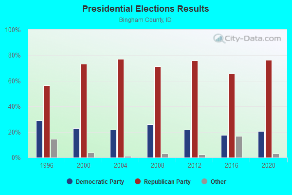
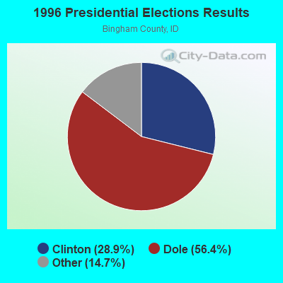
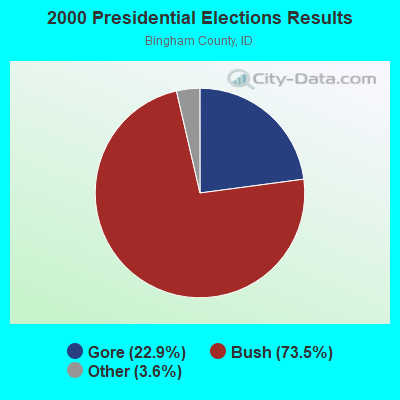

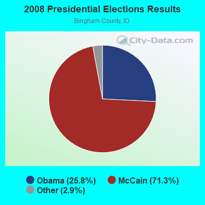
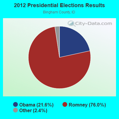
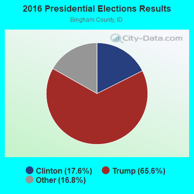
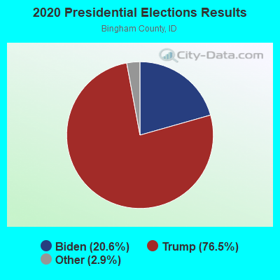
Graphs represent county-level data. Detailed 2008 Election Results
Religion statistics for Alridge, ID (based on Bingham County data)
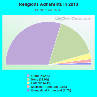
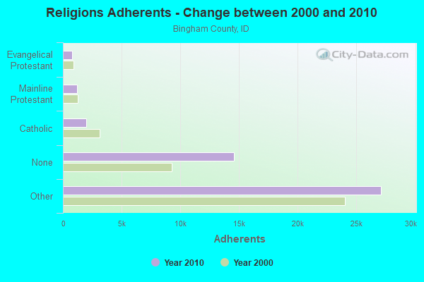
| Religion | Adherents | Congregations |
|---|---|---|
| Other | 27,106 | 75 |
| Catholic | 1,992 | 5 |
| Mainline Protestant | 1,188 | 8 |
| Evangelical Protestant | 757 | 13 |
| None | 14,564 | - |
Food Environment Statistics:
| Bingham County: | 1.38 / 10,000 pop. |
| Idaho: | 1.88 / 10,000 pop. |
| This county: | 0.23 / 10,000 pop. |
| State: | 0.28 / 10,000 pop. |
| Bingham County: | 0.46 / 10,000 pop. |
| Idaho: | 0.53 / 10,000 pop. |
| Bingham County: | 3.46 / 10,000 pop. |
| State: | 3.87 / 10,000 pop. |
| Here: | 5.07 / 10,000 pop. |
| State: | 7.75 / 10,000 pop. |
| This county: | 10.5% |
| Idaho: | 7.7% |
| Bingham County: | 30.9% |
| Idaho: | 25.7% |
| This county: | 18.0% |
| State: | 11.7% |
Strongest AM radio stations in Alridge:
- KZNR (690 AM; 10 kW; BLACKFOOT, ID; Owner: WESTERN COMMUNICATIONS, INC.)
- KID (590 AM; 5 kW; IDAHO FALLS, ID; Owner: CITICASTERS LICENSES, L.P.)
- KUPI (980 AM; 5 kW; AMMON, ID; Owner: RAY GROTH OIL COMPANY, INC.)
- KBLI (1620 AM; 10 kW; BLACKFOOT, ID; Owner: WESTERN COMMUNICATIONS, INC.)
- KZNI (1260 AM; 5 kW; IDAHO FALLS, ID)
- KBRV (790 AM; 5 kW; SODA SPRINGS, ID; Owner: CARIBOU BROADCASTING INC.)
- KSEI (930 AM; 5 kW; POCATELLO, ID; Owner: PACIFIC EMPIRE COMMUNICATIONS CORP.)
- KALL (700 AM; 50 kW; NORTH SALT LAKE CITY, UT; Owner: CITICASTERS LICENSES, L.P.)
- KIQN (1010 AM; 50 kW; TOOELE, UT)
- KSL (1160 AM; 50 kW; SALT LAKE CITY, UT; Owner: BONNEVILLE HOLDING COMPANY)
- KRSV (1210 AM; 5 kW; AFTON, WY; Owner: WESTERN WYOMING RADIO, INC.)
- KBOI (670 AM; 50 kW; BOISE, ID; Owner: CITADEL BROADCASTING COMPANY)
- KSOS (800 AM; 10 kW; BRIGHAM CITY, UT; Owner: SIMMONS-SLC, LS, LLC)
Strongest FM radio stations in Alridge:
- KPLV (105.5 FM; IDAHO FALLS, ID; Owner: WESTERN BROADCASTING, LS, LLC)
- KBJX (107.9 FM; SHELLEY, ID; Owner: PACIFIC EMPIRE COMMUNICATIONS CORP)
- K275AB (102.9 FM; FREEDOM, WY; Owner: LOWER STAR VALLEY TV ASSOCIATION)
- KQEO (107.1 FM; IDAHO FALLS, ID; Owner: SAND HILL MEDIA CORP.)
- K209BO (89.7 FM; TETONIA, ID; Owner: FAITH COMMUNICATIONS CORPORATION)
- KLLP (98.5 FM; CHUBBUCK, ID; Owner: CITICASTERS LICENSES, L.P.)
- K299AH (107.7 FM; POCATELLO, ID; Owner: UNIVERSITY OF UTAH)
- KCHQ (102.1 FM; DRIGGS, ID; Owner: TED W. AUSTIN, JR.)
- KFTZ (103.3 FM; IDAHO FALLS, ID; Owner: WESTERN BROADCASTING, LS, LLC)
- KISU-FM (91.1 FM; POCATELLO, ID; Owner: IDAHO STATE UNIVERSITY)
- KCVI (101.5 FM; BLACKFOOT, ID; Owner: WESTERN COMMUNICATIONS, INC.)
- KLCE (97.3 FM; BLACKFOOT, ID; Owner: WESTERN COMMUNICATIONS, INC.)
- KID-FM (96.1 FM; IDAHO FALLS, ID; Owner: CITICASTERS LICENSES, L.P.)
- KUPI-FM (99.1 FM; IDAHO FALLS, ID; Owner: RAY GROTH OIL COMPANY, INC.)
- KMGI (102.5 FM; POCATELLO, ID; Owner: PACIFIC EMPIRE COMMUNICATIONS CORP.)
- KPKY (94.9 FM; POCATELLO, ID; Owner: CITICASTERS LICENSES, L.P.)
- KZBQ (93.7 FM; POCATELLO, ID; Owner: IDAHO WIRELESS CORPORATION)
- K249CM (97.7 FM; POCATELLO, ID; Owner: WESTERN COMMUNICATIONS, INC.)
- K266AF (101.1 FM; POCATELLO, ID; Owner: WESTERN COMMUNICATIONS, INC.)
- KBYI (100.5 FM; REXBURG, ID; Owner: BRIGHAM YOUNG UNIVERSITY-IDAHO)
TV broadcast stations around Alridge:
- K59BV (Channel 59; LAVA HOT SPRINGS, ID; Owner: STATE BOARD OF EDUCATION (IEPBS))

- 52.8%Utility gas
- 24.5%Electricity
- 18.4%Wood
- 4.3%Fuel oil, kerosene, etc.

- 71.4%Bottled, tank, or LP gas
- 28.6%Electricity
Alridge compared to Idaho state average:
- Unemployed percentage significantly below state average.
- Black race population percentage significantly below state average.
- Hispanic race population percentage below state average.
- Median age significantly below state average.
- Foreign-born population percentage significantly below state average.
- Renting percentage significantly below state average.
- Length of stay since moving in significantly above state average.
- Number of rooms per house significantly below state average.
- House age significantly below state average.
- Number of college students below state average.
- Percentage of population with a bachelor's degree or higher significantly below state average.