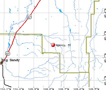
Agency, Montana
Submit your own pictures of this place and show them to the world
- OSM Map
- General Map
- Google Map
- MSN Map
| Males: 177 | |
| Females: 171 |
| Median resident age: | 20.9 years |
| Montana median age: | 37.5 years |
Zip codes: 59521.
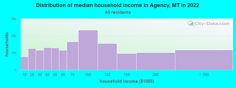
| Agency: | $39,899 |
| MT: | $67,631 |
Estimated per capita income in 2022: $26,788 (it was $12,990 in 2000)
Agency CDP income, earnings, and wages data
Estimated median house or condo value in 2022: $76,158 (it was $20,000 in 2000)
| Agency: | $76,158 |
| MT: | $366,400 |
Detailed information about poverty and poor residents in Agency, MT
Compare current foreclosures near your location:
| Photo | Address | Area | Beds / Baths | Price | Details |
|---|---|---|---|---|---|

|
#1
Bayberry Cir
Columbus, OH 43207
|
1,564 sq. feet
|
1 baths 3 beds |
$127,500
|
show details |

|
#2
S High St
Columbus, OH 43207
|
1,678 sq. feet
|
2 baths 4 beds |
$31,900
|
show details |

|
#3
E 21st Ave
Columbus, OH 43211
|
1,061 sq. feet
|
1 baths 3 beds |
$179,900
|
show details |

|
#4
Roundelay Rd N
Reynoldsburg, OH 43068
|
1,712 sq. feet
|
2 baths 3 beds |
show details | |

|
#5
E Howard Rd
Columbus, OH 43207
|
1,056 sq. feet
|
1 baths 3 beds |
show details | |

|
#6
London Groveport Rd
Grove City, OH 43123
|
816 sq. feet
|
1 baths 2 beds |
show details | |

|
#7
Chidley St
Galloway, OH 43119
|
1,502 sq. feet
|
1 baths 3 beds |
show details | |

|
#8
Summertree Ln
Westerville, OH 43081
|
2,496 sq. feet
|
2 baths 3 beds |
show details | |

|
#9
E Lincoln Ave
Columbus, OH 43214
|
874 sq. feet
|
1 baths 3 beds |
show details | |

|
#10
Fergus Rd
Grove City, OH 43123
|
3,312 sq. feet
|
2 baths 4 beds |
show details |
| Photo | Address | Area | Beds / Baths | Price | Details |
|---|---|---|---|---|---|

|
#11
Rosewood Ct
Powell, OH 43065
|
2,801 sq. feet
|
3 baths 4 beds |
show details | |

|
#12
Armada Rd
Columbus, OH 43232
|
1,028 sq. feet
|
1 baths 4 beds |
show details | |

|
#13
N Roys Ave
Columbus, OH 43204
|
1,248 sq. feet
|
2 baths 3 beds |
show details | |

|
#14
N Roys Ave
Columbus, OH 43204
|
648 sq. feet
|
2 baths 3 beds |
show details | |

|
#15
S Richardson Ave
Columbus, OH 43204
|
1,520 sq. feet
|
2 baths 3 beds |
show details | |

|
#16
Meadowbrook Dr
Columbus, OH 43207
|
1,752 sq. feet
|
2 baths 4 beds |
show details | |

|
#17
Executive Ct
Westerville, OH 43081
|
1,811 sq. feet
|
2 baths 3 beds |
show details | |

|
#18
High Free Pike
West Jefferson, OH 43162
|
1,216 sq. feet
|
2 baths 4 beds |
show details | |

|
#19
Falls Peak Ln
Delaware, OH 43015
|
1,352 sq. feet
|
2 baths 2 beds |
show details | |

|
#20
Ashgrove Dr
Grove City, OH 43123
|
1,772 sq. feet
|
2 baths 4 beds |
show details |
| Photo | Address | Area | Beds / Baths | Price | Details |
|---|---|---|---|---|---|

|
#21
Lehner Rd
Columbus, OH 43224
|
1,628 sq. feet
|
2 baths 4 beds |
show details | |

|
#22
Grasmere Ave
Columbus, OH 43211
|
720 sq. feet
|
1 baths 2 beds |
show details | |

|
#23
E Welch Ave
Columbus, OH 43207
|
1,864 sq. feet
|
2 baths 4 beds |
show details | |

|
#24
Wrexham Ave
Columbus, OH 43223
|
1,235 sq. feet
|
1 baths 3 beds |
show details | |

|
#25
Kelton Ave
Columbus, OH 43206
|
1,080 sq. feet
|
1 baths 3 beds |
show details | |

|
#26
Hamilton Ave
Columbus, OH 43211
|
1,061 sq. feet
|
1 baths 3 beds |
show details | |

|
#27
Striebel Ct
Columbus, OH 43227
|
925 sq. feet
|
1 baths 3 beds |
show details | |

|
#28
S Champion Ave
Columbus, OH 43207
|
1,157 sq. feet
|
1 baths 2 beds |
show details | |

|
#29
Fairfield Ave
Columbus, OH 43203
|
984 sq. feet
|
1 baths 2 beds |
show details | |

|
#30
N 18th St
Columbus, OH 43203
|
1,690 sq. feet
|
1 baths 4 beds |
show details |
| Photo | Address | Area | Beds / Baths | Price | Details |
|---|---|---|---|---|---|

|
#31
Cannonade Ct
Columbus, OH 43230
|
2,023 sq. feet
|
2 baths 3 beds |
show details | |

|
#32
Glenmate Ct
Columbus, OH 43223
|
1,050 sq. feet
|
1 baths 3 beds |
show details | |

|
#33
Safford Ave
Columbus, OH 43223
|
784 sq. feet
|
1 baths 2 beds |
show details | |

|
#34
Chester Rd
Columbus, OH 43221
|
3,300 sq. feet
|
4 baths 5 beds |
show details | |

|
#35
Upton Rd E
Columbus, OH 43232
|
852 sq. feet
|
1 baths 3 beds |
show details | |

|
#36
Whittman Ct
Plain City, OH 43064
|
3,186 sq. feet
|
3 baths 4 beds |
show details | |

|
#37
Hildreth Ave
Columbus, OH 43203
|
1,798 sq. feet
|
2 baths 4 beds |
show details | |

|
#38
Gladys Rd
Columbus, OH 43228
|
832 sq. feet
|
1 baths 3 beds |
show details | |

|
#39
Mccutcheon Rd
Columbus, OH 43219
|
2,130 sq. feet
|
2 baths 3 beds |
show details | |

|
#40
Hedgerow Rd
Columbus, OH 43220
|
1,102 sq. feet
|
2 baths 2 beds |
show details |
| Photo | Address | Area | Beds / Baths | Price | Details |
|---|---|---|---|---|---|

|
#41
Stephen St
Grove City, OH 43123
|
1,027 sq. feet
|
1 baths 3 beds |
show details | |

|
#42
Messner Dr
Hilliard, OH 43026
|
832 sq. feet
|
1 baths 2 beds |
show details | |

|
#43
Falene Pl
Galloway, OH 43119
|
1,178 sq. feet
|
1 baths 3 beds |
show details | |

|
#44
Autumn Wind Dr
Grove City, OH 43123
|
1,697 sq. feet
|
2 baths 3 beds |
show details | |

|
#45
Wesson Dr
Columbus, OH 43232
|
1,200 sq. feet
|
1 baths 3 beds |
show details | |

|
#46
Stoneybrook B 21a
Hilliard, OH 43026
|
1,031 sq. feet
|
1 baths 3 beds |
show details | |

|
#47
Almont Dr
Columbus, OH 43229
|
1,563 sq. feet
|
2 baths 5 beds |
show details | |

|
#48
Windy Hill Ln
Galloway, OH 43119
|
1,350 sq. feet
|
2 baths 3 beds |
show details | |

|
#49
Conway Dr
Columbus, OH 43227
|
1,225 sq. feet
|
1 baths 3 beds |
show details | |

|
Check over 1 million property listings on Foreclosure.com!
|
browse all offers | |||

- 30092.6%American Indian alone
- 185.6%White alone
- 30.9%Hispanic
- 20.6%Two or more races
- 10.3%Asian alone
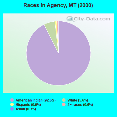
Races in Agency detailed stats: ancestries, foreign born residents, place of birth
 Recent articles from our blog. Our writers, many of them Ph.D. graduates or candidates, create easy-to-read articles on a wide variety of topics.

 | Interesting read for those who want to move to Montana (47 replies) |
| CNN reporting GOP candidate body slamming reporter (120 replies) |
| Security/Home Sitting in Bigfork (6 replies) |
| Crow Agency, MT (5 replies) |
| Crow Agency. Anyone familiar with the area? (13 replies) |
| Winter Weather Alerts, 2013-14 (Web cams first post) (36 replies) |
Latest news from Agency, MT collected exclusively by city-data.com from local newspapers, TV, and radio stations
Ancestries: Irish (1.2%), Swedish (1.2%).
Current Local Time: MST time zone
Elevation: 2540 feet
Land area: 8.58 square miles.
Population density: 41 people per square mile (very low).
17 residents are foreign born (4.0% North America, 1.2% Asia).
| This place: | 5.2% |
| Montana: | 1.8% |
| Agency CDP: | 2.8% ($557) |
| Montana: | 1.3% ($1,212) |
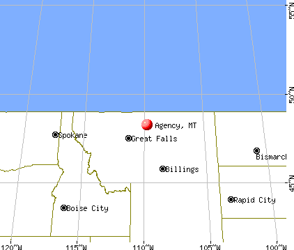
Nearest city with pop. 50,000+: Great Falls, MT  (87.4 miles , pop. 56,690).
Nearest city with pop. 200,000+: East Seattle, WA (575.3 miles , pop. 480,100).
Nearest city with pop. 1,000,000+: Phoenix, AZ (1025.7 miles , pop. 1,321,045).
Nearest cities:
), ), ), ), ), ), )Latitude: 48.26 N, Longitude: 109.77 W

| Here: | 6.0% |
| Montana: | 3.8% |
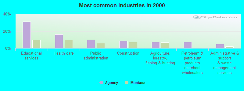
- Educational services (31.2%)
- Health care (16.2%)
- Public administration (10.0%)
- Construction (8.8%)
- Agriculture, forestry, fishing & hunting (7.5%)
- Petroleum & petroleum products merchant wholesalers (7.5%)
- Administrative & support & waste management services (5.0%)
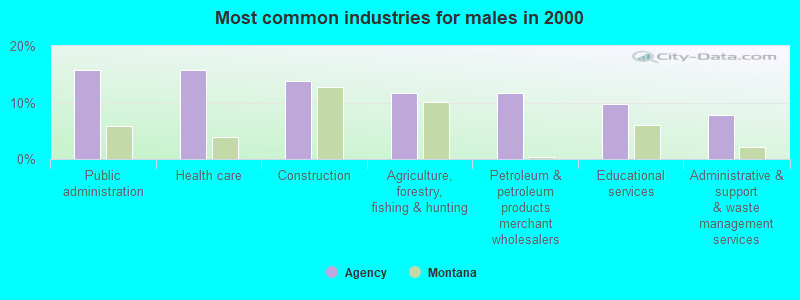
- Public administration (15.7%)
- Health care (15.7%)
- Construction (13.7%)
- Agriculture, forestry, fishing & hunting (11.8%)
- Petroleum & petroleum products merchant wholesalers (11.8%)
- Educational services (9.8%)
- Administrative & support & waste management services (7.8%)

- Educational services (69.0%)
- Health care (17.2%)
- Religious, grantmaking, civic, professional, similar organizations (13.8%)
- Preschool, kindergarten, elementary, and middle school teachers (8.8%)
- Physicians and surgeons (8.8%)
- Carpenters (8.8%)
- Postsecondary teachers (7.5%)
- Building and grounds cleaning and maintenance occupations (7.5%)
- Driver/sales workers and truck drivers (7.5%)
- Top executives (6.2%)

- Physicians and surgeons (13.7%)
- Carpenters (13.7%)
- Postsecondary teachers (11.8%)
- Building and grounds cleaning and maintenance occupations (11.8%)
- Driver/sales workers and truck drivers (11.8%)
- Top executives (9.8%)
- Other food preparation and serving workers, including supervisors (7.8%)

- Preschool, kindergarten, elementary, and middle school teachers (24.1%)
- Other management occupations, except farmers and farm managers (17.2%)
- Other teachers, instructors, education, training, and library occupations (17.2%)
- Religious workers (13.8%)
- Information and record clerks, except customer service representatives (10.3%)
- Supervisors and other personal care and service workers, except child care workers (10.3%)
- Other office and administrative support workers, including supervisors (6.9%)
Average climate in Agency, Montana
Based on data reported by over 4,000 weather stations


Earthquake activity:
Agency-area historical earthquake activity is significantly above Montana state average. It is 468% greater than the overall U.S. average.On 8/18/1959 at 06:37:13, a magnitude 7.7 (7.7 UK, Class: Major, Intensity: VIII - XII) earthquake occurred 258.7 miles away from the city center, causing $26,000,000 total damage
On 10/28/1983 at 14:06:06, a magnitude 7.3 (6.2 MB, 7.3 MS, 7.0 MW) earthquake occurred 347.5 miles away from Agency center, causing 2 deaths (2 shaking deaths) and 3 injuries, causing $15,000,000 total damage
On 7/6/2017 at 06:30:17, a magnitude 5.8 (5.8 MW, Depth: 7.6 mi, Class: Moderate, Intensity: VI - VII) earthquake occurred 161.7 miles away from the city center
On 6/30/1975 at 18:54:13, a magnitude 6.1 (5.6 MB, 5.9 MS, 6.1 UK, 6.1 ML, Class: Strong, Intensity: VII - IX) earthquake occurred 252.1 miles away from the city center
On 3/31/2020 at 23:52:30, a magnitude 6.5 (6.5 MW, Depth: 7.5 mi) earthquake occurred 365.7 miles away from Agency center
On 7/26/2005 at 04:08:37, a magnitude 5.7 (5.7 MB, 5.2 MS, 5.6 MW) earthquake occurred 238.1 miles away from the city center
Magnitude types: body-wave magnitude (MB), local magnitude (ML), surface-wave magnitude (MS), moment magnitude (MW)
Natural disasters:
The number of natural disasters in Sanders County (10) is smaller than the US average (15).Major Disasters (Presidential) Declared: 6
Emergencies Declared: 1
Causes of natural disasters: Floods: 5, Fires: 3, Storms: 3, Landslides: 2, Heavy Rain: 1, Hurricane: 1, Snow: 1, Other: 1 (Note: some incidents may be assigned to more than one category).

Colleges/universities with over 2000 students nearest to Agency:
- Montana State University-Billings (about 181 miles; Billings, MT; Full-time enrollment: 4,319)
- Montana State University (about 190 miles; Bozeman, MT; FT enrollment: 12,942)
- The University of Montana (about 219 miles; Missoula, MT; FT enrollment: 13,602)
- Sheridan College (about 277 miles; Sheridan, WY; FT enrollment: 2,070)
- Brigham Young University-Idaho (about 323 miles; Rexburg, ID; FT enrollment: 30,522)
- North Idaho College (about 328 miles; Coeur d'Alene, ID; FT enrollment: 4,684)
- Spokane Community College (about 354 miles; Spokane, WA; FT enrollment: 6,482)
Points of interest:
Cemetery: Rocky Boy Gravel (1). Display/hide its location on the map
Creeks: Daychild Creek (A), Sundance Creek (B). Display/hide their locations on the map
Birthplace of: Tuff Harris - Player of and football, George Horse-Capture - Curator, Sharon Stewart-Peregoy - Montana legislator.
| This place: | 4.1 people |
| Montana: | 2.5 people |
| This place: | 82.3% |
| Whole state: | 66.6% |
| This place: | 5.1% |
| Whole state: | 5.0% |
No gay or lesbian households reported
| This place: | 23.9% |
| Whole state: | 14.6% |
| This place: | 10.0% |
| Whole state: | 5.8% |
For population 15 years and over in Agency:
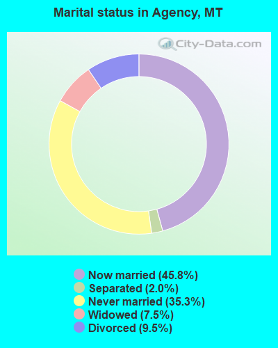
- Never married: 35.3%
- Now married: 45.8%
- Separated: 2.0%
- Widowed: 7.5%
- Divorced: 9.5%
For population 25 years and over in Agency:
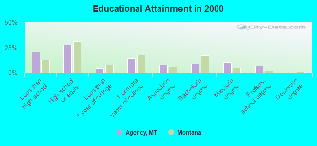
- High school or higher: 79.2%
- Bachelor's degree or higher: 25.8%
- Graduate or professional degree: 17.0%
- Unemployed: 33.3%
- Mean travel time to work (commute): 13.2 minutes
| Here: | 16.0 |
| Montana average: | 10.4 |

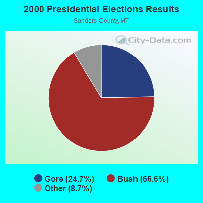


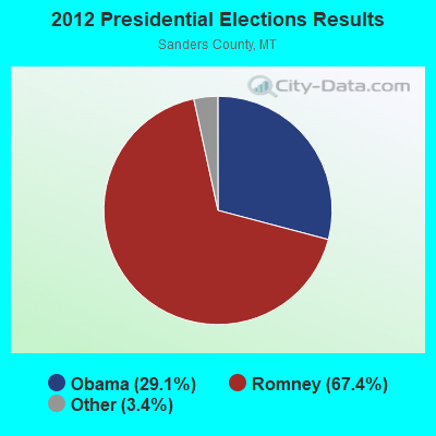


Graphs represent county-level data. Detailed 2008 Election Results
Religion statistics for Agency, MT (based on Sanders County data)
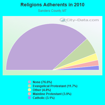
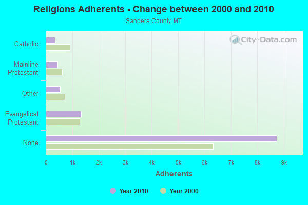
| Religion | Adherents | Congregations |
|---|---|---|
| Evangelical Protestant | 1,333 | 18 |
| Other | 543 | 4 |
| Mainline Protestant | 447 | 9 |
| Catholic | 350 | 4 |
| None | 8,740 | - |
Food Environment Statistics:
| Sanders County: | 4.54 / 10,000 pop. |
| Montana: | 2.55 / 10,000 pop. |
| Sanders County: | 0.91 / 10,000 pop. |
| Montana: | 0.48 / 10,000 pop. |
| Sanders County: | 6.36 / 10,000 pop. |
| State: | 4.69 / 10,000 pop. |
| Here: | 10.90 / 10,000 pop. |
| State: | 10.38 / 10,000 pop. |
| This county: | 8.5% |
| Montana: | 7.2% |
| Sanders County: | 22.3% |
| Montana: | 23.1% |
| This county: | 14.5% |
| State: | 10.7% |
Strongest AM radio stations in Agency:
- KOJM (610 AM; 1 kW; HAVRE, MT; Owner: NEW MEDIA BROADCASTERS, INC.)
- KERR (750 AM; 50 kW; POLSON, MT; Owner: ANDERSON RADIO BROADCASTING, INC.)
- KOFI (1180 AM; 50 kW; KALISPELL, MT; Owner: KOFI, INC.)
- KMON (560 AM; 5 kW; GREAT FALLS, MT; Owner: COMMONWEALTH LICENSE SUBSIDIARY, LLC)
- KSEN (1150 AM; 10 kW; SHELBY, MT; Owner: CAPSTAR TX LIMITED PARTNERSHIP)
- KEIN (1310 AM; 5 kW; GREAT FALLS, MT; Owner: MUNSON RADIO, INC.)
- KGVW (640 AM; 10 kW; BELGRADE, MT; Owner: GALLATIN VALLEY WITNESS, INC.)
- KXMR (710 AM; 50 kW; BISMARCK, ND; Owner: RADIO BISMARCK MANDAN, LLC)
- KBOI (670 AM; 50 kW; BOISE, ID; Owner: CITADEL BROADCASTING COMPANY)
- KKGR (680 AM; daytime; 5 kW; EAST HELENA, MT; Owner: KKGR, INC.)
- KTBI (810 AM; daytime; 50 kW; EPHRATA, WA; Owner: TACOMA BROADCASTERS, INCORPORATED)
- KTWO (1030 AM; 50 kW; CASPER, WY; Owner: CITICASTERS LICENSES, L.P.)
- KGA (1510 AM; 50 kW; SPOKANE, WA; Owner: CITADEL BROADCASTING COMPANY)
Strongest FM radio stations in Agency:
- KXEI (95.1 FM; HAVRE, MT; Owner: HI-LINE RADIO FELLOWSHIP, INC.)
- KNMC (90.1 FM; HAVRE, MT; Owner: NORTHERN MONTANA COLLEGE)
- KPQX (92.5 FM; HAVRE, MT; Owner: NEW MEDIA BROADCASTERS, INC.)
- KRYK (101.3 FM; CHINOOK, MT; Owner: NEW MEDIA BROADCASTERS, INC)
- KEHT (100.3 FM; GREAT FALLS, MT; Owner: GEORGE S. FLINN, JR.)
- K261CC (100.1 FM; CHESTER, MT; Owner: RANDALL D. ROCKS)
TV broadcast stations around Agency:
- KBBJ (Channel 9; HAVRE, MT; Owner: SUNBELT COMMUNICATIONS COMPANY)
- K52CI (Channel 52; HAVRE, MT; Owner: CONTINENTAL TELEVISION NETWORK, INC.)
Agency fatal accident list:
Oct 15, 2006 01:35 AM, Sr-234, Lat: 48.287360, Lon: -109.727300, Vehicles: 1, Persons: 2, Fatalities: 1
- National Bridge Inventory (NBI) Statistics
- 1Number of bridges
- 3ft / 0.6mTotal length
- 1,400Total average daily traffic
- 140Total average daily truck traffic
- 1,638Total future (year 2040) average daily traffic
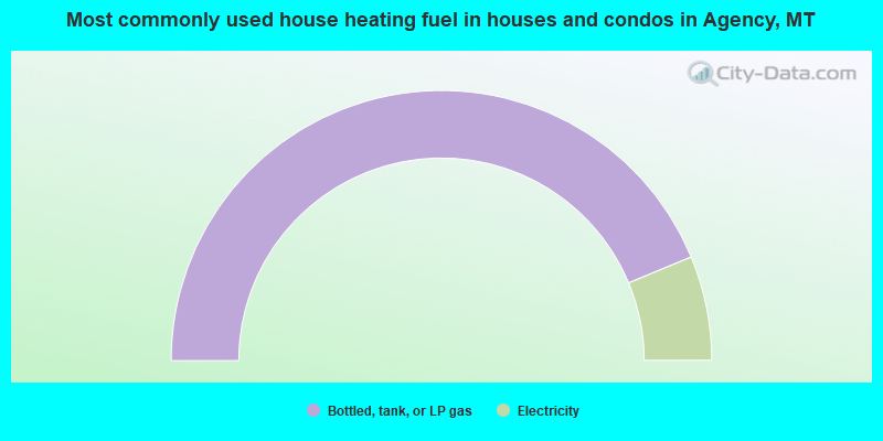
- 87.5%Bottled, tank, or LP gas
- 12.5%Electricity
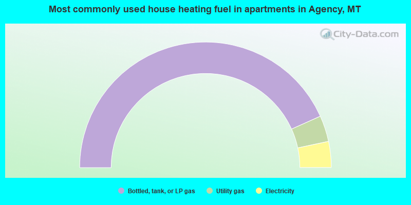
- 86.7%Bottled, tank, or LP gas
- 6.7%Utility gas
- 6.7%Electricity
Agency compared to Montana state average:
- Median household income below state average.
- Median house value significantly below state average.
- Unemployed percentage above state average.
- Black race population percentage significantly below state average.
- Hispanic race population percentage significantly below state average.
- Median age significantly below state average.
- Foreign-born population percentage significantly above state average.
- Renting percentage significantly below state average.
- Length of stay since moving in significantly above state average.
- Number of rooms per house significantly below state average.
- House age significantly below state average.