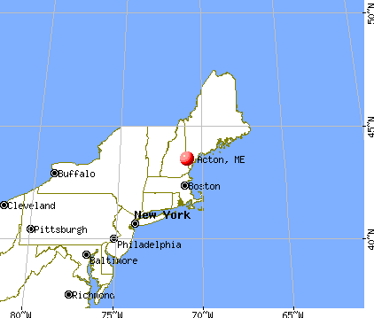
Acton, Maine
Submit your own pictures of this town and show them to the world
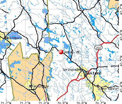
- OSM Map
- General Map
- Google Map
- MSN Map
Population change since 2000: +14.1%
 |
| Males: 1,247 | |
| Females: 1,200 |
| Median resident age: | 45.7 years |
| Maine median age: | 43.0 years |
Zip codes: 04001.
| Acton: | $73,301 |
| ME: | $69,543 |
Estimated per capita income in 2022: $39,563 (it was $19,447 in 2000)
Acton town income, earnings, and wages data
Estimated median house or condo value in 2022: $389,047 (it was $121,800 in 2000)
| Acton: | $389,047 |
| ME: | $290,600 |
Mean prices in 2022: all housing units: $451,552; detached houses: $470,451; townhouses or other attached units: $577,335; in 2-unit structures: $383,179; in 3-to-4-unit structures: $310,696; in 5-or-more-unit structures: $252,113; mobile homes: $105,501
Detailed information about poverty and poor residents in Acton, ME
Compare current foreclosures near Acton, ME:
| Photo | Address | Area | Beds / Baths | Price | Details |
|---|---|---|---|---|---|

|
#1
Nason St # B
Sanford, ME 04073
|
1,320 sq. feet
|
1 baths 3 beds |
show details | |

|
#2
High St
Farmington, NH 03835
|
1,252 sq. feet
|
2 baths 3 beds |
show details | |

|
#3
Charles St
Farmington, NH 03835
|
963 sq. feet
|
1 baths 3 beds |
show details | |

|
#4
Hobart St
Rochester, NH 03867
|
1,204 sq. feet
|
1 baths 4 beds |
show details | |

|
#5
Stuart Lane
Lebanon, ME 04027
|
960 sq. feet
|
2 baths 3 beds |
show details | |

|
#6
Frank C Gilman Hwy
Alton, NH 03809
|
1,712 sq. feet
|
1 baths 3 beds |
show details | |

|
#7
Keay Rd
Berwick, ME 03901
|
2,556 sq. feet
|
2 baths - beds |
show details | |

|
#8
Biddeford Rd
Alfred, ME 04002
|
- sq. feet
|
- baths - beds |
show details | |

|
#9
Limestone Ln
Rochester, NH 03867
|
- sq. feet
|
- baths - beds |
show details | |

|
#10
Chick Rd
Lebanon, ME 04027
|
- sq. feet
|
- baths - beds |
show details |
| Photo | Address | Area | Beds / Baths | Price | Details |
|---|---|---|---|---|---|

|
#11
Jackson St # B
Sanford, ME 04073
|
- sq. feet
|
- baths - beds |
show details | |

|
#12
Basswood St
Alfred, ME 04002
|
- sq. feet
|
- baths - beds |
show details | |

|
#13
Glendon St
Wolfeboro, NH 03894
|
- sq. feet
|
- baths - beds |
show details | |

|
#14
Main St Apt 404
Sanford, ME 04073
|
- sq. feet
|
- baths - beds |
show details | |

|
#15
Central St Apt 33
Farmington, NH 03835
|
- sq. feet
|
- baths - beds |
show details | |

|
#16
T M Wentworth Rd
Lebanon, ME 04027
|
- sq. feet
|
- baths - beds |
show details | |

|
#17
Main St
Springvale, ME 04083
|
- sq. feet
|
- baths - beds |
show details | |

|
#18
Stoneham Rd
Sanbornville, NH 03872
|
- sq. feet
|
- baths - beds |
show details | |

|
#19
White Mountain Hwy
Milton, NH 03851
|
- sq. feet
|
- baths - beds |
show details | |

|
#20
Hooper Rd
Shapleigh, ME 04076
|
528 sq. feet
|
- baths - beds |
show details |
| Photo | Address | Area | Beds / Baths | Price | Details |
|---|---|---|---|---|---|

|
#21
Ross Corner Rd
Shapleigh, ME 04076
|
- sq. feet
|
- baths - beds |
show details | |

|
#22
Benjamin Dr
Ossipee, NH 03864
|
- sq. feet
|
- baths - beds |
show details | |

|
#23
Heath Rd
Sanbornville, NH 03872
|
- sq. feet
|
- baths - beds |
show details | |

|
#24
Sandstone Ln
Rochester, NH 03867
|
- sq. feet
|
- baths - beds |
show details | |

|
#25
Sokokis Ave
Limington, ME 04049
|
- sq. feet
|
- baths - beds |
show details | |

|
#26
Tall Pines Ln
Parsonsfield, ME 04047
|
- sq. feet
|
- baths - beds |
show details | |

|
#27
Stair Fls
Rochester, NH 03868
|
- sq. feet
|
- baths - beds |
show details | |

|
#28
Dewey St
Rochester, NH 03867
|
- sq. feet
|
- baths - beds |
show details | |

|
#29
N Main St
Wolfeboro, NH 03894
|
- sq. feet
|
- baths - beds |
show details | |

|
#30
School St
Farmington, NH 03835
|
- sq. feet
|
- baths - beds |
show details |
| Photo | Address | Area | Beds / Baths | Price | Details |
|---|---|---|---|---|---|

|
#31
Wilkinson Swamp Rd
Effingham, NH 03882
|
- sq. feet
|
- baths - beds |
show details | |

|
#32
Clark Rd
Wolfeboro, NH 03894
|
- sq. feet
|
- baths - beds |
show details | |

|
#33
Center St
Wolfeboro, NH 03894
|
- sq. feet
|
- baths - beds |
show details | |

|
#34
Pine Knoll Dr
Farmington, NH 03835
|
- sq. feet
|
- baths - beds |
show details | |

|
#35
Pond Rd
Sanbornville, NH 03872
|
- sq. feet
|
- baths - beds |
show details | |

|
#36
New Dam Rd
North Waterboro, ME 04061
|
- sq. feet
|
- baths - beds |
show details | |

|
#37
Elm St
Limerick, ME 04048
|
- sq. feet
|
- baths - beds |
show details | |

|
#38
Harvard St
Sanford, ME 04073
|
- sq. feet
|
- baths - beds |
show details | |

|
#39
Little River Rd
Lebanon, ME 04027
|
- sq. feet
|
- baths - beds |
show details | |

|
#40
Sam Plummer Rd
Milton, NH 03851
|
- sq. feet
|
- baths - beds |
show details |
| Photo | Address | Area | Beds / Baths | Price | Details |
|---|---|---|---|---|---|

|
#41
Center Rd
Milton, NH 03851
|
- sq. feet
|
- baths - beds |
show details | |

|
#42
Hobart St
Rochester, NH 03867
|
- sq. feet
|
- baths - beds |
show details | |

|
Check over 1 million property listings on Foreclosure.com!
|
browse all offers | |||

- 2,37897.2%White alone
- 301.2%Hispanic
- 100.4%Black alone
- 100.4%American Indian alone
- 110.4%Two or more races
- 70.3%Asian alone
- 10.04%Other race alone

Races in Acton detailed stats: ancestries, foreign born residents, place of birth
According to our research of Maine and other state lists, there were 3 registered sex offenders living in Acton, Maine as of May 23, 2024.
The ratio of all residents to sex offenders in Acton is 816 to 1.
The ratio of registered sex offenders to all residents in this city is lower than the state average.
 Recent articles from our blog. Our writers, many of them Ph.D. graduates or candidates, create easy-to-read articles on a wide variety of topics.

 | The best place to live in Maine. (394 replies) |
| Tax Friendly, Modern, Family-Sized, Reasonably Priced Homes (14 replies) |
| Acton (2 replies) |
| Hurricane Irene (110 replies) |
| Acton Maine Building Codes and Permits (1 reply) |
| Any thoughts on Acton? (2 replies) |
Latest news from Acton, ME collected exclusively by city-data.com from local newspapers, TV, and radio stations
Ancestries: English (27.9%), Irish (13.4%), French (13.1%), French Canadian (9.5%), United States (9.2%), German (7.4%).
Current Local Time: EST time zone
Incorporated on 03/06/1830
Elevation: 720 feet
Land area: 37.7 square miles.
Population density: 65 people per square mile (very low).
40 residents are foreign born
| This town: | 1.9% |
| Maine: | 2.9% |
| Acton town: | 1.0% ($1,267) |
| Maine: | 1.5% ($1,417) |
Nearest city with pop. 50,000+: Portland, ME  (34.2 miles , pop. 64,249).
Nearest city with pop. 200,000+: Boston, MA (85.2 miles , pop. 589,141).
Nearest city with pop. 1,000,000+: Bronx, NY (240.0 miles , pop. 1,332,650).
Nearest cities:
), ), ), ), ), ), Latitude: 43.55 N, Longitude: 70.93 W
Area code: 207

Single-family new house construction building permits:
- 2022: 17 buildings, average cost: $191,800
- 2021: 20 buildings, average cost: $191,800
- 2020: 17 buildings, average cost: $191,800
- 2019: 16 buildings, average cost: $191,800
- 2018: 17 buildings, average cost: $191,800
- 2017: 17 buildings, average cost: $191,900
- 2016: 19 buildings, average cost: $191,100
- 2015: 14 buildings, average cost: $198,500
- 2014: 23 buildings, average cost: $175,000
- 2013: 21 buildings, average cost: $175,000
- 2012: 21 buildings, average cost: $175,000
- 2011: 19 buildings, average cost: $175,000
- 2010: 27 buildings, average cost: $175,000
- 2009: 28 buildings, average cost: $175,000
- 2008: 19 buildings, average cost: $175,000
- 2007: 25 buildings, average cost: $175,000
- 2006: 30 buildings, average cost: $175,000
- 2005: 27 buildings, average cost: $112,000
- 2004: 27 buildings, average cost: $112,000
- 2003: 26 buildings, average cost: $112,000
- 2002: 28 buildings, average cost: $112,100
- 2001: 24 buildings, average cost: $111,300
- 2000: 19 buildings, average cost: $117,100
- 1999: 20 buildings, average cost: $109,200
- 1998: 28 buildings, average cost: $90,700
- 1997: 16 buildings, average cost: $92,300


| Here: | 3.8% |
| Maine: | 3.4% |


- Construction (9.1%)
- Educational services (9.1%)
- Accommodation & food services (8.1%)
- Health care (6.5%)
- Computer & electronic products (4.1%)
- Public administration (4.0%)
- Finance & insurance (3.8%)

- Construction (17.1%)
- Accommodation & food services (5.4%)
- Public administration (4.4%)
- Repair & maintenance (4.4%)
- Educational services (4.4%)
- Transportation equipment (4.0%)
- Miscellaneous manufacturing (4.0%)

- Educational services (14.5%)
- Accommodation & food services (11.2%)
- Health care (10.1%)
- Personal & laundry services (6.2%)
- Finance & insurance (5.7%)
- Computer & electronic products (4.4%)
- Food & beverage stores (4.4%)

- Other production occupations, including supervisors (5.2%)
- Preschool, kindergarten, elementary, and middle school teachers (4.6%)
- Other management occupations, except farmers and farm managers (4.3%)
- Other sales and related occupations, including supervisors (4.2%)
- Metal workers and plastic workers (4.1%)
- Material recording, scheduling, dispatching, and distributing workers (3.6%)
- Retail sales workers, except cashiers (3.4%)

- Other production occupations, including supervisors (6.0%)
- Metal workers and plastic workers (6.0%)
- Carpenters (5.2%)
- Other management occupations, except farmers and farm managers (5.0%)
- Electrical equipment mechanics and other installation, maintenance, and repair workers, including supervisors (5.0%)
- Other sales and related occupations, including supervisors (4.8%)
- Retail sales workers, except cashiers (3.8%)

- Preschool, kindergarten, elementary, and middle school teachers (7.3%)
- Secretaries and administrative assistants (5.5%)
- Information and record clerks, except customer service representatives (5.1%)
- Nursing, psychiatric, and home health aides (5.1%)
- Other office and administrative support workers, including supervisors (4.6%)
- Other production occupations, including supervisors (4.4%)
- Material recording, scheduling, dispatching, and distributing workers (4.2%)
Average climate in Acton, Maine
Based on data reported by over 4,000 weather stations


(lower is better)

Air Quality Index (AQI) level in 2023 was 48.8. This is significantly better than average.
| City: | 48.8 |
| U.S.: | 72.6 |

Ozone [ppb] level in 2023 was 29.7. This is about average. Closest monitor was 3.9 miles away from the city center.
| City: | 29.7 |
| U.S.: | 33.3 |
Tornado activity:
Acton-area historical tornado activity is significantly above Maine state average. It is 65% smaller than the overall U.S. average.
On 10/10/1966, a category F2 (max. wind speeds 113-157 mph) tornado 11.2 miles away from the Acton town center caused between $5000 and $50,000 in damages.
On 6/9/1953, a category F3 (max. wind speeds 158-206 mph) tornado 40.0 miles away from the town center injured 5 people and caused between $5000 and $50,000 in damages.
Earthquake activity:
Acton-area historical earthquake activity is significantly above Maine state average. It is 73% smaller than the overall U.S. average.On 10/16/2012 at 23:12:25, a magnitude 4.7 (4.7 ML, Depth: 10.0 mi, Class: Light, Intensity: IV - V) earthquake occurred 14.2 miles away from the city center
On 4/20/2002 at 10:50:47, a magnitude 5.3 (5.3 ML, Depth: 3.0 mi, Class: Moderate, Intensity: VI - VII) earthquake occurred 152.8 miles away from Acton center
On 1/19/1982 at 00:14:42, a magnitude 4.7 (4.5 MB, 4.7 MD, 4.5 LG) earthquake occurred 33.7 miles away from the city center
On 10/7/1983 at 10:18:46, a magnitude 5.3 (5.1 MB, 5.3 LG, 5.1 ML) earthquake occurred 172.7 miles away from the city center
On 4/20/2002 at 10:50:47, a magnitude 5.2 (5.2 MB, 4.2 MS, 5.2 MW, 5.0 MW) earthquake occurred 153.0 miles away from Acton center
On 8/21/1996 at 07:54:14, a magnitude 3.8 (3.8 LG, 3.6 LG, Depth: 6.2 mi, Class: Light, Intensity: II - III) earthquake occurred 48.7 miles away from the city center
Magnitude types: regional Lg-wave magnitude (LG), body-wave magnitude (MB), duration magnitude (MD), local magnitude (ML), surface-wave magnitude (MS), moment magnitude (MW)
Natural disasters:
The number of natural disasters in York County (31) is a lot greater than the US average (15).Major Disasters (Presidential) Declared: 23
Emergencies Declared: 8
Causes of natural disasters: Floods: 21, Storms: 16, Winter Storms: 6, Snows: 5, Winds: 3, Heavy Rains: 2, Hurricanes: 2, Blizzard: 1, Ice Storm: 1, Mudslide: 1, Snowfall: 1, Snowstorm: 1, Tornado: 1, Tropical Storm: 1 (Note: some incidents may be assigned to more than one category).
Hospitals and medical centers near Acton:
- HUGGINS HOSPITAL Critical Access Hospitals (about 14 miles away; WOLFEBORO, NH)
- VNA HOSPICE OF S CARROLL CO AND VICINITY (Hospital, about 14 miles away; WOLFEBORO, NH)
- WOLFEBORO BAY CARE AND REHABILITATION CENTER (Nursing Home, about 14 miles away; WOLFEBORO, NH)
- MOUNTAIN VIEW NURSING HOME (Nursing Home, about 15 miles away; OSSIPEE, NH)
- SANFORD HEALTH CARE FACILITY (Nursing Home, about 15 miles away; SANFORD, ME)
- YOUR VNA (Home Health Center, about 15 miles away; ROCHESTER, NH)
Airports located in Acton:
- Buzzy's Field Airport (ME89) (Runways: 1)
- Old Acton Airfield Airport (02ME) (Runways: 1)
Colleges/universities with over 2000 students nearest to Acton:
- University of New England (about 29 miles; Biddeford, ME; Full-time enrollment: 4,539)
- University of New Hampshire-Main Campus (about 29 miles; Durham, NH; FT enrollment: 15,243)
- Saint Joseph's College of Maine (about 30 miles; Standish, ME; FT enrollment: 2,010)
- University of Southern Maine (about 34 miles; Portland, ME; FT enrollment: 6,647)
- Southern Maine Community College (about 36 miles; South Portland, ME; FT enrollment: 4,666)
- NHTI-Concord's Community College (about 38 miles; Concord, NH; FT enrollment: 2,865)
- Plymouth State University (about 41 miles; Plymouth, NH; FT enrollment: 4,838)
Private high school in Acton:
Public elementary/middle school in Acton:
- ACTON ELEMENTARY SCHOOL (Students: 276, Location: 700 MILTON MILLS ROAD, Grades: KG-8)
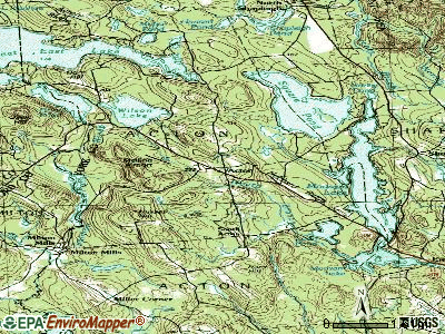
Points of interest:
Notable locations in Acton: Camp Sa -Gis -Ca (A), Acton Fairgrounds (B), Acton Volunteer Fire Department (C), Acton Public Library (D). Display/hide their locations on the map
Church in Acton: Maple Grove Church (A). Display/hide its location on the map
Lakes and reservoirs: Wilson Lake (A), Hansen Pond (B), Loon Pond (C), Moose Pond (D), Swan Pond (E), Great East Lake (F), Salmon Falls River Reservoir (G). Display/hide their locations on the map
Streams, rivers, and creeks: Heath Brook (A). Display/hide its location on the map
Birthplace of: Joshua Maria Young - Bishop, Nathan Clifford Ricker - Architect.
Drinking water stations with addresses in Acton and their reported violations in the past:
IRON TAILS SALOON (Population served: 600, Groundwater):Past monitoring violations:APPLE VALLEY CAMPGROUND (Population served: 350, Groundwater):
- 17 routine major monitoring violations
Past health violations:ACTON ELEMENTARY SCHOOL (Population served: 330, Groundwater):Past monitoring violations:
- MCL, Monthly (TCR) - In AUG-2013, Contaminant: Coliform. Follow-up actions: St Compliance achieved (SEP-27-2013), St Public Notif requested (NOV-20-2013), St Formal NOV issued (NOV-20-2013), St Public Notif received (APR-01-2014)
- One routine major monitoring violation
- One minor monitoring violation
Past health violations:THE SHED (Population served: 300, Groundwater):Past monitoring violations:
- MCL, Monthly (TCR) - In AUG-2008, Contaminant: Coliform. Follow-up actions: St Public Notif requested (AUG-28-2008), St Formal NOV issued (AUG-28-2008), St Public Notif received (SEP-05-2008), St Compliance achieved (MAR-25-2009)
- MCL, Monthly (TCR) - Between APR-2008 and JUN-2008, Contaminant: Coliform. Follow-up actions: St Public Notif requested (JUL-07-2008), St Formal NOV issued (JUL-07-2008), St Public Notif received (JUL-16-2008), St Compliance achieved (JUN-22-2009)
- MCL, Monthly (TCR) - In AUG-2007, Contaminant: Coliform. Follow-up actions: St Public Notif requested (SEP-07-2007), St Formal NOV issued (SEP-07-2007), St Public Notif received (OCT-02-2007), St Compliance achieved (APR-03-2008)
- MCL, Monthly (TCR) - In FEB-2007, Contaminant: Coliform. Follow-up actions: St Public Notif requested (MAR-09-2007), St Violation/Reminder Notice (MAR-09-2007), St Public Notif received (JUN-20-2007), St Compliance achieved (APR-03-2008)
- MCL, Monthly (TCR) - In NOV-2006, Contaminant: Coliform. Follow-up actions: St Public Notif requested (NOV-16-2006), St Violation/Reminder Notice (NOV-16-2006), St Public Notif received (NOV-30-2006), St Compliance achieved (SEP-24-2007)
- MCL, Monthly (TCR) - In OCT-2006, Contaminant: Coliform. Follow-up actions: St Public Notif requested (OCT-17-2006), St Violation/Reminder Notice (OCT-17-2006), St Public Notif received (NOV-30-2006), St Compliance achieved (SEP-24-2007)
- MCL, Monthly (TCR) - Between JUL-2006 and SEP-2006, Contaminant: Coliform. Follow-up actions: St Public Notif requested (OCT-03-2006), St Violation/Reminder Notice (OCT-03-2006), St Public Notif received (OCT-12-2006), St Compliance achieved (SEP-24-2007)
- Monitoring, Repeat Major (TCR) - In MAR-2007, Contaminant: Coliform (TCR). Follow-up actions: St Public Notif requested (APR-24-2007), St Violation/Reminder Notice (APR-24-2007), St Public Notif received (MAY-03-2007), St Compliance achieved (JUL-12-2007)
- One routine major monitoring violation
Past health violations:Past monitoring violations:
- MCL, Monthly (TCR) - In MAY-2010, Contaminant: Coliform. Follow-up actions: St Public Notif requested (MAY-17-2010), St Formal NOV issued (MAY-17-2010), St Public Notif received (MAR-25-2011), St Compliance achieved (MAR-28-2011)
- Monitoring, Repeat Major (TCR) - In APR-2005, Contaminant: Coliform (TCR). Follow-up actions: St Public Notif requested (MAY-12-2005), St Violation/Reminder Notice (MAY-12-2005), St Public Notif received (NOV-10-2005), St Compliance achieved (JAN-09-2008)
- Monitoring, Repeat Major (TCR) - In MAR-2005, Contaminant: Coliform (TCR). Follow-up actions: St Public Notif requested (APR-11-2005), St Violation/Reminder Notice (APR-11-2005), St Public Notif received (NOV-10-2005), St Compliance achieved (JAN-09-2008)
- 27 routine major monitoring violations
- 17 regular monitoring violations
| This town: | 2.4 people |
| Maine: | 2.3 people |
| This town: | 67.9% |
| Whole state: | 62.9% |
| This town: | 8.1% |
| Whole state: | 9.4% |
Likely homosexual households (counted as self-reported same-sex unmarried-partner households)
- Lesbian couples: 1.1% of all households
- Gay men: 0.7% of all households
| This town: | 10.5% |
| Whole state: | 10.9% |
| This town: | 6.0% |
| Whole state: | 4.1% |
For population 15 years and over in Acton:

- Never married: 19.1%
- Now married: 65.6%
- Separated: 0.9%
- Widowed: 5.4%
- Divorced: 9.0%
For population 25 years and over in Acton:
- High school or higher: 86.2%
- Bachelor's degree or higher: 19.9%
- Graduate or professional degree: 6.2%
- Unemployed: 5.9%
- Mean travel time to work (commute): 36.1 minutes


| Here: | 10.0 |
| Maine average: | 11.2 |


Graphs represent county-level data. Detailed 2008 Election Results
Religion statistics for Acton, ME (based on York County data)


| Religion | Adherents | Congregations |
|---|---|---|
| Catholic | 40,283 | 16 |
| Mainline Protestant | 11,480 | 64 |
| Evangelical Protestant | 6,086 | 51 |
| Other | 1,847 | 18 |
| Orthodox | 625 | 3 |
| Black Protestant | 119 | 1 |
| None | 136,691 | - |
Food Environment Statistics:
| York County: | 2.24 / 10,000 pop. |
| Maine: | 2.80 / 10,000 pop. |
| This county: | 0.05 / 10,000 pop. |
| State: | 0.14 / 10,000 pop. |
| York County: | 2.09 / 10,000 pop. |
| Maine: | 2.20 / 10,000 pop. |
| York County: | 4.23 / 10,000 pop. |
| State: | 5.75 / 10,000 pop. |
| Here: | 12.53 / 10,000 pop. |
| State: | 11.02 / 10,000 pop. |
| This county: | 7.7% |
| Maine: | 8.2% |
| York County: | 24.0% |
| Maine: | 25.0% |
Strongest AM radio stations in Acton:
- WGIN (930 AM; 10 kW; ROCHESTER, NH; Owner: CAPSTAR TX LIMITED PARTNERSHIP)
- WMTW (870 AM; 10 kW; GORHAM, ME; Owner: RADIO PARTNERS OF MAINE, L.P.)
- WASR (1420 AM; 5 kW; WOLFEBORO, NH; Owner: RADIO WOLFEBORO, INC.)
- WRKO (680 AM; 50 kW; BOSTON, MA; Owner: ENTERCOM BOSTON LICENSE, LLC)
- WGAN (560 AM; 5 kW; PORTLAND, ME; Owner: SAGA COMMUNICATIONS OF NEW ENGLAND, LLC)
- WEEI (850 AM; 50 kW; BOSTON, MA; Owner: ENTERCOM BOSTON LICENSE, LLC)
- WBZ (1030 AM; 50 kW; BOSTON, MA; Owner: INFINITY BROADCASTING OPERATIONS, INC.)
- WTSN (1270 AM; 5 kW; DOVER, NH; Owner: GARRISON CITY BROADCASTING, INC.)
- WPHX (1220 AM; 1 kW; SANFORD, ME; Owner: FNX BROADCASTING L.L.C.)
- WCRN (830 AM; 50 kW; WORCESTER, MA; Owner: CARTER BROADCASTING CORPORATION)
- WZAN (970 AM; 5 kW; PORTLAND, ME; Owner: SAGA COMMUNICATIONS OF NEW ENGLAND, LLC)
- WWZN (1510 AM; 50 kW; BOSTON, MA; Owner: ROSE CITY RADIO CORPORATION)
- WKOX (1200 AM; 50 kW; FRAMINGHAM, MA; Owner: CAPSTAR TX LIMITED PARTNERSHIP)
Strongest FM radio stations in Acton:
- WSCY (106.9 FM; MOULTONBOROUGH, NH; Owner: NORTHEAST COMMUNICATIONS CORPORATION)
- WMEA (90.1 FM; PORTLAND, ME; Owner: MAINE PUBLIC BROADCASTING CORPORATION)
- WPHX-FM (92.1 FM; SANFORD, ME; Owner: FNX BROADCASTING LLC)
- WSEW (88.5 FM; SANFORD, ME; Owner: WORD RADIO EDUCATIONAL FOUNDATION)
- WPKQ (103.7 FM; NORTH CONWAY, NH; Owner: CITADEL BROADCASTING COMPANY)
- WHOM (94.9 FM; MT. WASHINGTON, NH; Owner: CITADEL BROADCASTING COMPANY)
- WMEX (106.5 FM; FARMINGTON, NH; Owner: WIMMEX, LLC)
- WLKZ (104.9 FM; WOLFEBORO, NH; Owner: TELE-MEDIA COMPANY OF NEW HAMPSHIRE, L.L.C.)
- WVFM (105.7 FM; CAMPTON, NH; Owner: DEVON BROADCASTING COMPANY, INC.)
- WBLM (102.9 FM; PORTLAND, ME; Owner: CITADEL BROADCASTING COMPANY)
- WNHI (93.3 FM; BELMONT, NH; Owner: CONCORD BROADCASTING, L.L.C.)
- WUBB (95.3 FM; YORK CENTER, ME; Owner: CAPSTAR TX LIMITED PARTNERSHIP)
- WPNH-FM (100.1 FM; PLYMOUTH, NH; Owner: NORTHEAST COMMUNICATIONS CORPORATION)
- WOKQ (97.5 FM; DOVER, NH; Owner: CITADEL BROADCASTING COMPANY)
- WJBQ (97.9 FM; PORTLAND, ME; Owner: CITADEL BROADCASTING COMPANY)
- WQSO (96.7 FM; ROCHESTER, NH; Owner: CAPSTAR TX LIMITED PARTNERSHIP)
- WTHT (107.5 FM; LEWISTON, ME; Owner: RADIO PARTNERS OF MAINE, L.P.)
- WCYY (94.3 FM; BIDDEFORD, ME; Owner: CITADEL BROADCASTING COMPANY)
- WRED (95.9 FM; SACO, ME; Owner: ATLANTIC COAST RADIO, LLC)
- WPOR (101.9 FM; PORTLAND, ME; Owner: SAGA COMMUNICATIONS OF NEW ENGLAND, LLC)
TV broadcast stations around Acton:
- WMEA-TV (Channel 26; BIDDEFORD, ME; Owner: MAINE PUBLIC BROADCASTING CORP.)
- WMTW-TV (Channel 8; POLAND SPRING, ME; Owner: WMTW BROADCAST GROUP, LLC)
- WCSH (Channel 6; PORTLAND, ME; Owner: PACIFIC AND SOUTHERN COMPANY, INC.)
- WGME-TV (Channel 13; PORTLAND, ME; Owner: WGME LICENSEE, LLC)
- WPXT (Channel 51; PORTLAND, ME; Owner: HMW, INC.)

- National Bridge Inventory (NBI) Statistics
- 3Number of bridges
- 10ft / 3.0mTotal length
- 3,260Total average daily traffic
- 162Total average daily truck traffic
- 2,752Total future (year 2036) average daily traffic
FCC Registered Antenna Towers:
17 (See the full list of FCC Registered Antenna Towers in Acton)FCC Registered Broadcast Land Mobile Towers:
4- Fire Dept Rt 109 & H Rd (Lat: 43.530639 Lon: -70.905056), Call Sign: KSZ322, Licensee ID: L00041130,
Assigned Frequencies: 33.8600 MHz, Grant Date: 04/12/1999, Expiration Date: 04/26/2004, Cancellation Date: 12/20/2001, Registrant: Acton, Town Of, 1725 Route 109, Acton, ME 04001-0604, Phone: (207) 636-1017
- Blueberry Hill Road (Lat: 43.482028 Lon: -70.916167), Type: Nntann, Structure height: 24 m, Overall height: 31 m, Call Sign: WPUF515, Licensee ID: L00040826,
Assigned Frequencies: 160.410 MHz, 154.995 MHz, Grant Date: 02/22/2002, Expiration Date: 08/22/2002, Cancellation Date: 12/22/2002, Certifier: Benjamin C Gore, Registrant: County Of York, 45 Kennebunk Road, Alfred, ME 04002, Phone: (207) 324-1046, Fax: (207) 324-1299, Email:
- 437 Sam Page Road (Lat: 43.534722 Lon: -70.904722), Call Sign: WQCG858,
Assigned Frequencies: 467.762 MHz, 467.812 MHz, 467.850 MHz, 467.875 MHz, 467.900 MHz, 467.925 MHz, 467.787 MHz, 467.837 MHz, Grant Date: 03/01/2005, Expiration Date: 03/01/2015, Cancellation Date: 05/02/2015, Certifier: Heather White, Registrant: Office Manager, 437 Sam Page Road, Acton, ME 04001, Phone: (207) 636-3576, Fax: (207) 636-1735, Email:
- Lat: 43.506472 Lon: -70.896444, Call Sign: WQYR343,
Assigned Frequencies: 462.262 MHz, 457.287 MHz, 451.362 MHz, 456.537 MHz, 451.387 MHz, Grant Date: 12/19/2016, Expiration Date: 12/19/2026, Certifier: Jonathan Ross, Registrant: Washington Radio Reports, Gettysburg, PA 17325, Phone: (717) 334-0668, Fax: (717) 334-6440, Email:
FCC Registered Amateur Radio Licenses:
24 (See the full list of FCC Registered Amateur Radio Licenses in Acton)FAA Registered Aircraft:
1- Aircraft: KENNEDY OLIVER P SEA REY AMPHIBIAN (Category: Amphibian, Seats: 2, Weight: Up to 12,499 Pounds), Engine: ROTAX 912ULS SERIES (100 HP) (Reciprocating)
N-Number: 770K, N770K, N-770K, Serial Number: 1DK002, Year manufactured: 1990, Airworthiness Date: 06/21/2013, Certificate Issue Date: 02/27/2019
Registrant (Individual): Shawn Thomas Huston, 711 13th St, Acton, ME 04001
2003 - 2018 National Fire Incident Reporting System (NFIRS) incidents
- Fire incident types reported to NFIRS in Acton, ME
- 7562.5%Structure Fires
- 3025.0%Outside Fires
- 1411.7%Mobile Property/Vehicle Fires
- 10.8%Other
 Based on the data from the years 2003 - 2018 the average number of fires per year is 8. The highest number of reported fires - 24 took place in 2009, and the least - 1 in 2013. The data has an increasing trend.
 When looking into fire subcategories, the most reports belonged to: Structure Fires (62.5%), and Outside Fires (25.0%).
- 80.2%Fuel oil, kerosene, etc.
- 10.3%Wood
- 7.3%Bottled, tank, or LP gas
- 2.0%Electricity
- 0.3%Utility gas

- 80.8%Fuel oil, kerosene, etc.
- 9.6%Wood
- 7.7%Bottled, tank, or LP gas
- 1.9%Electricity
Acton compared to Maine state average:
- Unemployed percentage below state average.
- Black race population percentage significantly below state average.
- Foreign-born population percentage below state average.
- Renting percentage significantly below state average.
- Length of stay since moving in significantly above state average.
- Number of rooms per house significantly below state average.
- House age significantly below state average.

|
|
Total of 51 patent applications in 2008-2024.