Bridge Statistics for Yardville-Groveville, New Jersey (NJ)
Condition, Traffic, Stress, Structural Evaluation, Project Costs
- National Bridge Inventory (NBI) Statistics
- 17Number of bridges
- 128ft / 39.0mTotal length
- $14,410,000Total costs
- 293,788Total average daily traffic
- 17,549Total average daily truck traffic
- National Bridge Inventory (NBI) Registered Bridges for Yardville-Groveville
- No street view available for this location
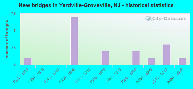
- New bridges - historical statistics
- 11920-1929
- 71950-1959
- 21970-1979
- 21990-1999
- 12000-2009
- 32010-2019
- 12020-2022

- Reconstructed bridges - Historical Statistics
- 12000-2009
- 22010-2019


- Bridge Condition - Deck
- 25.0%Excellent
- 25.0%Very good
- 16.7%Good
- 16.7%Satisfactory
- 16.7%Fair

- Bridge Condition - Superstructure
- 25.0%Excellent
- 41.7%Very good
- 16.7%Good
- 8.3%Satisfactory
- 8.3%Fair

- Bridge Condition - Substructure
- 8.3%Excellent
- 33.3%Very good
- 41.7%Good
- 16.7%Satisfactory

- Bridge Condition - Channel
- 12.5%Good
- 50.0%Satisfactory
- 37.5%Fair
Find on map >> Show street view
Structure Number: 319152, Location: 1.8 MILES NORTH RT 206JCT (Lat: 40.173631, Lng: -74.679419), Route carried "on" structure: US 130, Year Built: 1928, Year Reconstructed: 2019, Status: Open, Structure Length: 1.98m (6.50ft), Average Daily Traffic: 25,734 (year 2020), Truck Traffic: 4%, Average Future Daily Traffic: 30,884 (year 2040), Design Load: HL 93, Features Intersected: CROSSWICKS CREEK
Minimum Vertical Clearance: 30+ m (98+ ft), Kilometerpoint: 93.776, Lanes on structure: 4, Base Highway Network: Yes, Owner: State Highway Agency, Approaching Roadway Width: 28.7m (94.2ft), Skew: 20 degrees, Material/Design: Steel, Design/Construction: Stringer/Multi-beam, Number Of Spans In Main Unit: 1, Length of Maximum Span: 19.2m (63.0ft), Curb or Sidewalk Widths: Left: 1.8m (5.9ft), Right: 1.8m (5.9ft), Curb-To-Curb Width: 28.7m (94.2ft), Out-to-Out Width: 32.9m (107.9ft)
Condition: Deck: Excellent, Superstructure: Excellent, Substructure: Good, Channel: Satisfactory, Operating Rating: 96.9 metric tons, Method Used To Determine Operating Rating: Load and Resistance Factor Rating (LRFR) rating reported by rating factor(RF) method using HL-93 loadings, Inventory Rating: 94.0 metric tons, Method Used To Determine Inventory Rating: Load and Resistance Factor Rating (LRFR) rating reported by rating factor(RF) method using HL-93 loadings, Structural Evaluation: Better than present minimum criteria, Deck Geometry: Superior to present desirable criteria, Waterway Adequacy: Superior to present desirable criteria, Approach Roadway Alignment: Equal to present desirable criteria, Length Of Structure Improvement: 2.04m (6.69ft), Designated Inspection Frequency: Every 24 months, Underwater Inspection Frequency: Every 24 months, Inspection Date: August 2020, Underwater Inspection Date: March 2020, Bridge Improvement Cost: $4,636,000, Roadway Improvement Cost: $592,000, Total Project Cost: $8,277,000 ( Estimate for 2018), Deck Structure Type: Concrete Cast-file-Place, Wearing Surface/Protective System: Wearing Surface: Monolithic Concrete, Deck Protection: Epoxy Coated Reinforcing
Find on map >> Show street view
Structure Number: 1100007, Location: 0.25 mile South of US 130 (Lat: 40.174431, Lng: -74.673289), Route carried "on" structure: County highway 609, Year Built: 2021, Status: Open, Structure Length: 1.34m (4.40ft), Average Daily Traffic: 2,815 (year 2021), Truck Traffic: 3%, Average Future Daily Traffic: 3,435 (year 2041), Design Load: HL 93, Features Intersected: DOCTORS CREEK, Facility Carried by Structure: YDVILLE-GRVILLE RD
Minimum Vertical Clearance: 30+ m (98+ ft), Kilometerpoint: 0.579, Lanes on structure: 2, Owner: County Highway Agency, Approaching Roadway Width: 9.8m (32.2ft), Material/Design: Steel, Design/Construction: Stringer/Multi-beam, Number Of Spans In Main Unit: 1, Length of Maximum Span: 12.8m (42.0ft), Curb or Sidewalk Widths: Left: 1.5m (4.9ft), Right: 1.5m (4.9ft), Curb-To-Curb Width: 9.8m (32.2ft), Out-to-Out Width: 13.6m (44.6ft)
Condition: Deck: Excellent, Superstructure: Excellent, Substructure: Excellent, Channel: Satisfactory, Operating Rating: 89.8 metric tons, Method Used To Determine Operating Rating: Load Factor (LF), Inventory Rating: 68.0 metric tons, Method Used To Determine Inventory Rating: Load Factor (LF), Structural Evaluation: Superior to present desirable criteria, Deck Geometry: Meets minimum limits, Waterway Adequacy: Superior to present desirable criteria, Approach Roadway Alignment: Equal to present desirable criteria, Designated Inspection Frequency: Every 24 months, Inspection Date: June 2021, Bridge Improvement Cost: $795,000, Roadway Improvement Cost: $130,000, Total Project Cost: $1,282,000 ( Estimate for 2019), Deck Structure Type: Concrete Cast-file-Place, Wearing Surface/Protective System: Wearing Surface: Integral Concrete, Deck Protection: Galvanized Reinforcing
Find on map >> Show street view
Structure Number: 1100027, Location: 475' S. OF US 130 (Lat: 40.176369, Lng: -74.668589), Route carried "on" structure: County highway 672, Year Built: 2016, Status: Open, Structure Length: 1.92m (6.30ft), Average Daily Traffic: 6,185 (year 2021), Truck Traffic: 3%, Average Future Daily Traffic: 7,550 (year 2041), Design Load: HL 93, Features Intersected: DOCTORS CREEK
Minimum Vertical Clearance: 30+ m (98+ ft), Kilometerpoint: 3.026, Lanes on structure: 2, Owner: County Highway Agency, Approaching Roadway Width: 12.2m (40.0ft), Material/Design: Prestressed concrete, Design/Construction: Box Beam or Girders - Multiple, Number Of Spans In Main Unit: 1, Length of Maximum Span: 18.9m (62.0ft), Curb or Sidewalk Widths: Left: 1.8m (5.9ft), Right: 1.8m (5.9ft), Curb-To-Curb Width: 12.2m (40.0ft), Out-to-Out Width: 16.5m (54.1ft)
Condition: Deck: Very good, Superstructure: Very good, Substructure: Very good, Channel: Good, Operating Rating: 61.9 metric tons, Method Used To Determine Operating Rating: Load and Resistance Factor Rating (LRFR) rating reported by rating factor(RF) method using HL-93 loadings, Inventory Rating: 47.6 metric tons, Method Used To Determine Inventory Rating: Load and Resistance Factor Rating (LRFR) rating reported by rating factor(RF) method using HL-93 loadings, Structural Evaluation: Equal to present desirable criteria, Deck Geometry: Somewhat better than minimum adequacy, Waterway Adequacy: Superior to present desirable criteria, Approach Roadway Alignment: Equal to present desirable criteria, Designated Inspection Frequency: Every 24 months, Inspection Date: Febuary 2021, Bridge Improvement Cost: $1,601,000, Roadway Improvement Cost: $116,000, Total Project Cost: $2,347,000 ( Estimate for 2015), Deck Structure Type: Concrete Cast-file-Place, Wearing Surface/Protective System: Wearing Surface: Other, Deck Protection: Galvanized Reinforcing
Find on map >> Show street view
Structure Number: 1100028, Location: 1/2 MI WEST OF RTE 524 (Lat: 40.172461, Lng: -74.658769), Route carried "on" structure: City street , Year Built: 2001, Status: Open, Structure Length: 4.75m (15.58ft), Average Daily Traffic: 740 (year 2021), Truck Traffic: 3%, Average Future Daily Traffic: 900 (year 2041), Design Load: HS 25 or greater, Features Intersected: DOCTORS CREEK, Facility Carried by Structure: GRVEVLL-ALLNWN RD
Minimum Vertical Clearance: 30+ m (98+ ft), Kilometerpoint: 1.754, Lanes on structure: 2, Owner: County Highway Agency, Approaching Roadway Width: 9.8m (32.2ft), Skew: 1 degrees, Material/Design: Prestressed concrete, Design/Construction: Stringer/Multi-beam, Number Of Spans In Main Unit: 2, Length of Maximum Span: 22.6m (74.1ft), Curb-To-Curb Width: 9.9m (32.5ft), Out-to-Out Width: 10.9m (35.8ft)
Condition: Deck: Good, Superstructure: Very good, Substructure: Very good, Channel: Satisfactory, Operating Rating: 78.0 metric tons, Method Used To Determine Operating Rating: Load Factor (LF), Inventory Rating: 47.2 metric tons, Method Used To Determine Inventory Rating: Load Factor (LF), Structural Evaluation: Equal to present desirable criteria, Deck Geometry: Equal to present minimum criteria, Waterway Adequacy: Superior to present desirable criteria, Approach Roadway Alignment: Equal to present desirable criteria, Designated Inspection Frequency: Every 24 months, Inspection Date: Febuary 2021, Deck Structure Type: Concrete Cast-file-Place, Wearing Surface/Protective System: Wearing Surface: Monolithic Concrete, Deck Protection: Galvanized Reinforcing
Find on map >> Show street view
Structure Number: 1106713, Location: 0.5 MI S OF I-195 JCT (Lat: 40.192081, Lng: -74.665411), Route carried "on" structure: City street , Year Built: 1995, Status: Open, Structure Length: 1.16m (3.81ft), Average Daily Traffic: 12,174 (year 2021), Truck Traffic: 4%, Average Future Daily Traffic: 14,608 (year 2041), Design Load: HS 25 or greater, Features Intersected: BACK EDGE BROOK, Facility Carried by Structure: Hamilton-Yardville
Minimum Vertical Clearance: 30+ m (98+ ft), Kilometerpoint: 1.561, Lanes on structure: 2, Owner: County Highway Agency, Approaching Roadway Width: 15.2m (49.9ft), Material/Design: Prestressed concrete, Design/Construction: Slab, Number Of Spans In Main Unit: 1, Length of Maximum Span: 9.8m (32.2ft), Curb or Sidewalk Widths: Left: 1.5m (4.9ft), Right: 1.5m (4.9ft), Curb-To-Curb Width: 15.2m (49.9ft), Out-to-Out Width: 18.9m (62.0ft)
Condition: Deck: Satisfactory, Superstructure: Good, Substructure: Good, Channel: Fair, Operating Rating: 59.0 metric tons, Method Used To Determine Operating Rating: Load Factor (LF), Inventory Rating: 35.4 metric tons, Method Used To Determine Inventory Rating: Load Factor (LF), Structural Evaluation: Better than present minimum criteria, Deck Geometry: Superior to present desirable criteria, Waterway Adequacy: Better than present minimum criteria, Approach Roadway Alignment: Equal to present desirable criteria, Designated Inspection Frequency: Every 24 months, Inspection Date: Febuary 2021, Deck Structure Type: Concrete Cast-file-Place, Wearing Surface/Protective System: Wearing Surface: Monolithic Concrete, Deck Protection: Epoxy Coated Reinforcing
Find on map >> Show street view
Structure Number: 112215, Location: 0.5 MI S OF 130-524 JCT (Lat: 40.175361, Lng: -74.675611), Route carried "on" structure: US 130, Year Built: 1951, Year Reconstructed: 2019, Status: Open, Structure Length: 1.74m (5.71ft), Average Daily Traffic: 31,751 (year 2020), Truck Traffic: 4%, Average Future Daily Traffic: 38,778 (year 2040), Design Load: HL 93, Features Intersected: DOCTOR'S CREEK
Minimum Vertical Clearance: 30+ m (98+ ft), Kilometerpoint: 94.179, Lanes on structure: 4, Base Highway Network: Yes, Owner: State Highway Agency, Approaching Roadway Width: 23.8m (78.1ft), Skew: 31 degrees, Material/Design: Steel, Design/Construction: Stringer/Multi-beam, Number Of Spans In Main Unit: 1, Length of Maximum Span: 16.8m (55.1ft), Curb or Sidewalk Widths: Left: 1.8m (5.9ft), Right: 1.8m (5.9ft), Curb-To-Curb Width: 23.8m (78.1ft), Out-to-Out Width: 33.2m (108.9ft)
Condition: Deck: Excellent, Superstructure: Excellent, Substructure: Good, Channel: Fair, Operating Rating: 96.9 metric tons, Method Used To Determine Operating Rating: Load and Resistance Factor Rating (LRFR) rating reported by rating factor(RF) method using HL-93 loadings, Inventory Rating: 96.9 metric tons, Method Used To Determine Inventory Rating: Load and Resistance Factor Rating (LRFR) rating reported by rating factor(RF) method using HL-93 loadings, Structural Evaluation: Better than present minimum criteria, Deck Geometry: Superior to present desirable criteria, Waterway Adequacy: Equal to present minimum criteria, Approach Roadway Alignment: Equal to present desirable criteria, Length Of Structure Improvement: 1.74m (5.71ft), Designated Inspection Frequency: Every 24 months, Underwater Inspection Frequency: Every 24 months, Inspection Date: Febuary 2020, Underwater Inspection Date: March 2020, Bridge Improvement Cost: $174,000, Total Project Cost: $235,000 ( Estimate for 2020), Deck Structure Type: Concrete Cast-file-Place, Wearing Surface/Protective System: Wearing Surface: Monolithic Concrete, Deck Protection: Epoxy Coated Reinforcing
Find on map >> Show street view
Structure Number: 1122151, Location: 0.34 MI S. CR524 JCT (Lat: 40.176381, Lng: -74.673011), Route carried "on" structure: County highway 609, Year Built: 1951, Year Reconstructed: 2013, Status: Open, Structure Length: 3.66m (12.01ft), Average Daily Traffic: 2,879 (year 2021), Truck Traffic: 3%, Average Future Daily Traffic: 3,513 (year 2041), Design Load: HL 93, Features Intersected: ROUTE US 130, Facility Carried by Structure: GROVEVILLE ROAD
Minimum Vertical Clearance: 30+ m (98+ ft), Kilometerpoint: 0.386, Lanes on structure: 2, Lanes under structure: 4, Owner: State Highway Agency, Approaching Roadway Width: 9.1m (29.9ft), Skew: 2 degrees, Material/Design: Steel, Design/Construction: Stringer/Multi-beam, Number Of Spans In Main Unit: 2, Length of Maximum Span: 17.4m (57.1ft), Curb or Sidewalk Widths: Left: 1.8m (5.9ft), Right: 1.8m (5.9ft), Curb-To-Curb Width: 9.2m (30.2ft), Out-to-Out Width: 13.4m (44.0ft)
Condition: Deck: Very good, Superstructure: Very good, Substructure: Good, Operating Rating: 68.7 metric tons, Method Used To Determine Operating Rating: Load and Resistance Factor Rating (LRFR) rating reported by rating factor(RF) method using HL-93 loadings, Inventory Rating: 53.1 metric tons, Method Used To Determine Inventory Rating: Load and Resistance Factor Rating (LRFR) rating reported by rating factor(RF) method using HL-93 loadings, Structural Evaluation: Better than present minimum criteria, Deck Geometry: Meets minimum limits, Underclear: Equal to present minimum criteria, Approach Roadway Alignment: Equal to present desirable criteria, Designated Inspection Frequency: Every 24 months, Inspection Date: May 2021, Deck Structure Type: Concrete Cast-file-Place, Wearing Surface/Protective System: Wearing Surface: Monolithic Concrete, Deck Protection: Epoxy Coated Reinforcing
Find on map >> Show street view
Structure Number: 1122152, Location: 0.2 MI S OF RT 524 JCT (Lat: 40.177519, Lng: -74.669611), Route carried "on" structure: County highway 672, Year Built: 1951, Status: Open, Structure Length: 3.23m (10.60ft), Average Daily Traffic: 5,360 (year 2021), Truck Traffic: 3%, Average Future Daily Traffic: 6,432 (year 2041), Design Load: HS 20, Features Intersected: US 130
Minimum Vertical Clearance: 30+ m (98+ ft), Kilometerpoint: 3.170, Lanes on structure: 2, Lanes under structure: 5, Owner: State Highway Agency, Approaching Roadway Width: 12.2m (40.0ft), Material/Design: Steel, Design/Construction: Stringer/Multi-beam, Number Of Spans In Main Unit: 2, Length of Maximum Span: 15.5m (50.9ft), Curb or Sidewalk Widths: Left: 1.8m (5.9ft), Right: 1.8m (5.9ft), Curb-To-Curb Width: 12.2m (40.0ft), Out-to-Out Width: 16.6m (54.5ft)
Condition: Deck: Fair, Superstructure: Fair, Substructure: Satisfactory, Operating Rating: 56.2 metric tons, Method Used To Determine Operating Rating: Load Factor (LF), Inventory Rating: 33.6 metric tons, Method Used To Determine Inventory Rating: Load Factor (LF), Structural Evaluation: Somewhat better than minimum adequacy, Deck Geometry: Somewhat better than minimum adequacy, Underclear: Meets minimum limits, Approach Roadway Alignment: Better than present minimum criteria, Designated Inspection Frequency: Every 24 months, Inspection Date: March 2021, Deck Structure Type: Concrete Cast-file-Place, Wearing Surface/Protective System: Wearing Surface: Monolithic Concrete
Find on map >> Show street view
Structure Number: 1122156, Location: 1.59 Mi W of NJ Turnpike (Lat: 40.178481, Lng: -74.667889), Route carried "on" structure: County highway 524, Year Built: 1951, Status: Open, Structure Length: 3.87m (12.70ft), Average Daily Traffic: 11,985 (year 2020), Truck Traffic: 4%, Average Future Daily Traffic: 14,382 (year 2040), Design Load: HS 20, Features Intersected: US 130, Facility Carried by Structure: YRDVLLE-ALLNTWN RD
Minimum Vertical Clearance: 30+ m (98+ ft), Kilometerpoint: 3.508, Lanes on structure: 2, Lanes under structure: 4, Owner: State Highway Agency, Approaching Roadway Width: 12.2m (40.0ft), Skew: 3 degrees, Material/Design: Steel, Design/Construction: Stringer/Multi-beam, Number Of Spans In Main Unit: 2, Length of Maximum Span: 18.6m (61.0ft), Curb or Sidewalk Widths: Left: 1.8m (5.9ft), Right: 1.8m (5.9ft), Curb-To-Curb Width: 12.2m (40.0ft), Out-to-Out Width: 16.8m (55.1ft)
Condition: Deck: Fair, Superstructure: Satisfactory, Substructure: Satisfactory, Operating Rating: 89.8 metric tons, Method Used To Determine Operating Rating: Load Factor (LF), Inventory Rating: 64.4 metric tons, Method Used To Determine Inventory Rating: Load Factor (LF), Structural Evaluation: Equal to present minimum criteria, Deck Geometry: Somewhat better than minimum adequacy, Underclear: Somewhat better than minimum adequacy, Approach Roadway Alignment: Equal to present desirable criteria, Designated Inspection Frequency: Every 24 months, Inspection Date: June 2020, Deck Structure Type: Concrete Cast-file-Place, Wearing Surface/Protective System: Wearing Surface: Monolithic Concrete
Find on map >> Show street view
Structure Number: 112515, Location: 0.14 MI NO OF RT 130 JCT (Lat: 40.175911, Lng: -74.676461), Route carried "on" structure: State highway 156, Year Built: 1994, Status: Open, Structure Length: 1.71m (5.61ft), Average Daily Traffic: 1,576 (year 2021), Truck Traffic: 3%, Average Future Daily Traffic: 1,892 (year 2041), Design Load: HS 20, Features Intersected: DOCTORS CREEK
Minimum Vertical Clearance: 30+ m (98+ ft), Kilometerpoint: 0.225, Lanes on structure: 2, Owner: State Highway Agency, Approaching Roadway Width: 12.2m (40.0ft), Skew: 1 degrees, Material/Design: Prestressed concrete, Design/Construction: Box Beam or Girders - Multiple, Number Of Spans In Main Unit: 1, Length of Maximum Span: 15.8m (51.8ft), Curb or Sidewalk Widths: Left: 1.8m (5.9ft), Right: 0.0m, Curb-To-Curb Width: 12.2m (40.0ft), Out-to-Out Width: 14.8m (48.6ft)
Condition: Deck: Good, Superstructure: Very good, Substructure: Very good, Channel: Satisfactory, Inventory Rating: 44.5 metric tons, Method Used To Determine Inventory Rating: Load Factor (LF), Structural Evaluation: Equal to present desirable criteria, Deck Geometry: Better than present minimum criteria, Waterway Adequacy: Equal to present desirable criteria, Approach Roadway Alignment: Equal to present desirable criteria, Designated Inspection Frequency: Every 24 months, Inspection Date: March 2021, Deck Structure Type: Concrete Cast-file-Place, Wearing Surface/Protective System: Wearing Surface: Monolithic Concrete, Deck Protection: Epoxy Coated Reinforcing
Find on map >> Show street view
Structure Number: 1134157, Location: AT I-195 EXIT 3 (Lat: 40.198550, Lng: -74.663731), Route carried "on" structure: City street , Year Built: 1973, Status: Open, Structure Length: 7.44m (24.41ft), Average Daily Traffic: 21,470 (year 2021), Truck Traffic: 4%, Average Future Daily Traffic: 26,198 (year 2041), Design Load: HS 20, Features Intersected: I-195, Facility Carried by Structure: YARDVILE-HAM SQ RD
Minimum Vertical Clearance: 30+ m (98+ ft), Kilometerpoint: 2.334, Lanes on structure: 4, Lanes under structure: 6, Owner: State Highway Agency, Approaching Roadway Width: 15.2m (49.9ft), Skew: 3 degrees, Material/Design: Steel, Design/Construction: Stringer/Multi-beam, Number Of Spans In Main Unit: 2, Length of Maximum Span: 36.3m (119.1ft), Curb or Sidewalk Widths: Left: 1.8m (5.9ft), Right: 1.8m (5.9ft), Curb-To-Curb Width: 15.2m (49.9ft), Out-to-Out Width: 19.7m (64.6ft)
Condition: Deck: Satisfactory, Superstructure: Good, Substructure: Good, Operating Rating: 88.0 metric tons, Method Used To Determine Operating Rating: Load Factor (LF), Inventory Rating: 52.6 metric tons, Method Used To Determine Inventory Rating: Load Factor (LF), Structural Evaluation: Better than present minimum criteria, Deck Geometry: High priority of corrective action, Underclear: High priority of corrective action, Approach Roadway Alignment: Equal to present desirable criteria, Length Of Structure Improvement: 7.44m (24.41ft), Designated Inspection Frequency: Every 24 months, Inspection Date: April 2021, Bridge Improvement Cost: $1,973,000, Roadway Improvement Cost: $154,000, Total Project Cost: $2,269,000 ( Estimate for 2021), Deck Structure Type: Concrete Cast-file-Place, Wearing Surface/Protective System: Wearing Surface: Monolithic Concrete
Find on map >> Show street view
Structure Number: M05692S, Location: 3 MI North Int. 7 (Lat: 40.160400, Lng: -74.655356), Route carried "on" structure: Other road 95, Year Built: 2012, Status: Open, Structure Length: 6.25m (20.51ft), Average Daily Traffic: 29,108 (year 2020), Truck Traffic: 14%, Average Future Daily Traffic: 35,517 (year 2040), Design Load: HL 93, Features Intersected: Crosswicks Cr & U-Turn
Minimum Vertical Clearance: 30+ m (98+ ft), Kilometerpoint: 18.652, Lanes on structure: 3, Lanes under structure: 2, Base Highway Network: Yes, Toll: On toll road, Owner: State Toll Authority, Approaching Roadway Width: 16.8m (55.1ft), Material/Design: Steel continuous, Design/Construction: Stringer/Multi-beam, Number Of Spans In Main Unit: 2, Length of Maximum Span: 36.3m (119.1ft), Curb-To-Curb Width: 16.9m (55.4ft), Out-to-Out Width: 18.0m (59.1ft)
Condition: Deck: Very good, Superstructure: Very good, Substructure: Very good, Channel: Fair, Operating Rating: 54.4 metric tons, Method Used To Determine Operating Rating: Load and Resistance Factor Rating (LRFR) rating reported by rating factor(RF) method using HL-93 loadings, Inventory Rating: 41.8 metric tons, Method Used To Determine Inventory Rating: Load and Resistance Factor Rating (LRFR) rating reported by rating factor(RF) method using HL-93 loadings, Structural Evaluation: Equal to present desirable criteria, Deck Geometry: Equal to present minimum criteria, Underclear: High priority of corrective action, Waterway Adequacy: Superior to present desirable criteria, Approach Roadway Alignment: Equal to present desirable criteria, Designated Inspection Frequency: Every 24 months, Inspection Date: June 2020, Deck Structure Type: Concrete Cast-file-Place, Wearing Surface/Protective System: Wearing Surface: Monolithic Concrete, Deck Protection: Epoxy Coated Reinforcing
Find on map >> Show street view
Structure Number: 1122151, Location: 0.34 MI S. CR524 JCT (Lat: 40.176381, Lng: -74.673011), Route carried "under" structure: US 130, Year Built: 1951, Structure Length: 0. m, Average Daily Traffic: 31,303 (year 2021), Truck Traffic: 4%, Features Intersected: ROUTE US 130, Facility Carried by Structure: GROVEVILLE ROAD
Minimum Vertical Clearance: 4.94m (16.21ft), Kilometerpoint: 94.404, Lanes on structure: 2, Lanes under structure: 4, Material/Design: Steel, Design/Construction: Stringer/Multi-beam, Length of Maximum Span: 17.4m (57.1ft)
Find on map >> Show street view
Structure Number: 1122152, Location: 0.2 MI S OF RT 524 JCT (Lat: 40.177519, Lng: -74.669611), Route carried "under" structure: US 130, Year Built: 1951, Structure Length: 0. m, Average Daily Traffic: 24,739 (year 2021), Truck Traffic: 4%, Features Intersected: US 130, Facility Carried by Structure: S.BROAD ST.(CR672)
Minimum Vertical Clearance: 4.93m (16.17ft), Kilometerpoint: 94.742, Lanes on structure: 2, Lanes under structure: 5, Material/Design: Steel, Design/Construction: Stringer/Multi-beam, Length of Maximum Span: 15.5m (50.9ft)
Find on map >> Show street view
Structure Number: 1122156, Location: 1.59 Mi W of NJ Turnpike (Lat: 40.178481, Lng: -74.667889), Route carried "under" structure: US 130, Year Built: 1951, Structure Length: 0. m, Average Daily Traffic: 23,762 (year 2020), Truck Traffic: 4%, Features Intersected: US 130, Facility Carried by Structure: YRDVLLE-ALLNTWN RD
Minimum Vertical Clearance: 4.61m (15.12ft), Kilometerpoint: 94.951, Lanes on structure: 2, Lanes under structure: 4, Material/Design: Steel, Design/Construction: Stringer/Multi-beam, Length of Maximum Span: 18.6m (61.0ft)
Find on map >> Show street view
Structure Number: 1134157, Location: AT I-195 EXIT 3 (Lat: 40.198550, Lng: -74.663731), Route carried "under" structure: Interstate 195, Year Built: 1973, Structure Length: 0. m, Average Daily Traffic: 61,950 (year 2021), Truck Traffic: 9%, Features Intersected: I-195, Facility Carried by Structure: YARDVILE-HAM SQ RD
Minimum Vertical Clearance: 4.50m (14.76ft), Kilometerpoint: 5.423, Lanes on structure: 4, Lanes under structure: 6, Material/Design: Steel, Design/Construction: Stringer/Multi-beam, Length of Maximum Span: 36.3m (119.1ft)
Find on map >> Show street view
Structure Number: M05692S, Location: 3 MI North Int. 7 (Lat: 40.160400, Lng: -74.655356), Route carried "under" structure: Ramp Other road 95, Year Built: 2012, Structure Length: 0. m, Average Daily Traffic: 257 (year 2020), Truck Traffic: 1%, Features Intersected: Crosswicks Cr & U-Turn
Minimum Vertical Clearance: 4.90m (16.08ft), Kilometerpoint: 18.652, Lanes on structure: 3, Lanes under structure: 2, Toll: On toll road, Material/Design: Steel continuous, Design/Construction: Stringer/Multi-beam, Length of Maximum Span: 36.3m (119.1ft)