Bridge Statistics for Worth, Illinois (IL)
Condition, Traffic, Stress, Structural Evaluation, Project Costs
- National Bridge Inventory (NBI) Statistics
- 20Number of bridges
- 161ft / 49.2mTotal length
- $3,315,000Total costs
- 742,800Total average daily traffic
- 92,161Total average daily truck traffic
- National Bridge Inventory (NBI) Registered Bridges for Worth
- No street view available for this location
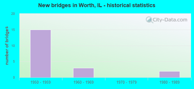
- New bridges - historical statistics
- 151950-1959
- 31960-1969
- 21980-1989

- Reconstructed bridges - Historical Statistics
- 11970-1979
- 11980-1989
- 01990-1999
- 12000-2009


- Bridge Condition - Deck
- 60.0%Good
- 10.0%Satisfactory
- 30.0%Fair

- Bridge Condition - Superstructure
- 10.0%Good
- 50.0%Satisfactory
- 30.0%Fair
- 10.0%Poor

- Bridge Condition - Substructure
- 40.0%Good
- 50.0%Satisfactory
- 10.0%Fair

- Bridge Condition - Channel
- 33.3%Very good
- 33.3%Good
- 33.3%Satisfactory
Find on map >> Show street view
Structure Number: 160322, Location: 0.3 M S 103RD ST (Lat: 41.700044, Lng: -87.797869), Route carried "on" structure: State highway 43, Year Built: 1960, Year Reconstructed: 1977, Status: Open, Structure Length: 3.20m (10.50ft), Average Daily Traffic: 41,100 (year 2021), Truck Traffic: 4%, Average Future Daily Traffic: 38,213 (year 2032), Design Load: HS 20, Features Intersected: STONEY CREEK
Minimum Vertical Clearance: 30+ m (98+ ft), Kilometerpoint: 21.645, Lanes on structure: 4, Base Highway Network: Yes, Owner: State Highway Agency, Approaching Roadway Width: 17.2m (56.4ft), Skew: 20 degrees, Material/Design: Concrete continuous, Design/Construction: Slab, Number Of Spans In Main Unit: 3, Length of Maximum Span: 12.1m (39.7ft), Curb or Sidewalk Widths: Left: 1.8m (5.9ft), Right: 1.8m (5.9ft), Curb-To-Curb Width: 17.2m (56.4ft), Out-to-Out Width: 26.8m (87.9ft)
Condition: Deck: Fair, Superstructure: Fair, Substructure: Satisfactory, Channel: Satisfactory, Operating Rating: 50.5 metric tons, Method Used To Determine Operating Rating: Load Factor (LF) rating reported by rating factor (RF) method using MS18 loading, Inventory Rating: 30.1 metric tons, Method Used To Determine Inventory Rating: Load Factor (LF) rating reported by rating factor (RF) method using MS18 loading, Structural Evaluation: Somewhat better than minimum adequacy, Deck Geometry: Somewhat better than minimum adequacy, Waterway Adequacy: Equal to present minimum criteria, Approach Roadway Alignment: Equal to present desirable criteria, Designated Inspection Frequency: Every 24 months, Inspection Date: January 2021, Deck Structure Type: Concrete Cast-file-Place, Wearing Surface/Protective System: Wearing Surface: Latex Concrete
Find on map >> Show street view
Structure Number: 160323, Location: 0.2 M N IL 83 (Lat: 41.678242, Lng: -87.797000), Route carried "on" structure: State highway 43, Year Built: 1964, Year Reconstructed: 1994, Status: Open, Structure Length: 13.01m (42.68ft), Average Daily Traffic: 30,800 (year 2021), Truck Traffic: 3%, Average Future Daily Traffic: 36,359 (year 2032), Design Load: HS 20, Features Intersected: CAL SAG CHANNEL
Minimum Vertical Clearance: 5.33m (17.49ft), Kilometerpoint: 19.215, Lanes on structure: 4, Base Highway Network: Yes, Owner: State Highway Agency, Approaching Roadway Width: 15.2m (49.9ft), Skew: 30 degrees, Navigation Control: Yes ( Vertical Clearance: 7.6m (24.9ft), Horizontal Clearance: 68.6m (225.1ft)), Material/Design: Steel, Design/Construction: Truss - Thru, Number Of Spans In Main Unit: 1, Number Of Approach Spans: 4, Length of Maximum Span: 90.8m (297.9ft), Curb or Sidewalk Widths: Left: 2.3m (7.5ft), Right: 2.3m (7.5ft), Curb-To-Curb Width: 15.8m (51.8ft), Out-to-Out Width: 22.6m (74.1ft)
Condition: Deck: Fair, Superstructure: Fair, Substructure: Fair, Channel: Very good, Operating Rating: 57.7 metric tons, Method Used To Determine Operating Rating: Load Factor (LF) rating reported by rating factor (RF) method using MS18 loading, Inventory Rating: 34.3 metric tons, Method Used To Determine Inventory Rating: Load Factor (LF) rating reported by rating factor (RF) method using MS18 loading, Structural Evaluation: Somewhat better than minimum adequacy, Deck Geometry: Meets minimum limits, Waterway Adequacy: Equal to present desirable criteria, Approach Roadway Alignment: Equal to present minimum criteria, Designated Inspection Frequency: Every 24 months, Critical Feature Inspection Frequency: Every 24 months, Inspection Date: May 2020, Critical Feature Inspection Date: May 2020, Deck Structure Type: Concrete Cast-file-Place, Wearing Surface/Protective System: Wearing Surface: Other
Find on map >> Show street view
Structure Number: 163025, Location: 0.6 M S 115TH P26 (Lat: 41.674694, Lng: -87.778186), Route carried "on" structure: Other road , Year Built: 1967, Year Reconstructed: 2014, Status: Open, Structure Length: 13.21m (43.34ft), Average Daily Traffic: 28,900 (year 2018), Truck Traffic: 3%, Average Future Daily Traffic: 27,913 (year 2032), Design Load: HS 20, Features Intersected: CAL SAG CHANNEL, Facility Carried by Structure: RIDGELAND AVE
Minimum Vertical Clearance: 30+ m (98+ ft), Kilometerpoint: 4.989, Lanes on structure: 4, Base Highway Network: Yes, Owner: County Highway Agency, Approaching Roadway Width: 16.2m (53.1ft), Skew: 30 degrees, Navigation Control: Yes ( Vertical Clearance: 5.2m (17.1ft), Horizontal Clearance: 68.6m (225.1ft)), Material/Design: Steel, Design/Construction: Truss - Thru, Number Of Spans In Main Unit: 1, Number Of Approach Spans: 4, Length of Maximum Span: 92.0m (301.8ft), Curb or Sidewalk Widths: Left: 1.5m (4.9ft), Right: 1.5m (4.9ft), Curb-To-Curb Width: 16.2m (53.1ft), Out-to-Out Width: 22.6m (74.1ft)
Condition: Deck: Fair, Superstructure: Poor, Substructure: Satisfactory, Channel: Good, Operating Rating: 55.1 metric tons, Method Used To Determine Operating Rating: Load Factor (LF) rating reported by rating factor (RF) method using MS18 loading, Inventory Rating: 33.0 metric tons, Method Used To Determine Inventory Rating: Load Factor (LF) rating reported by rating factor (RF) method using MS18 loading, Structural Evaluation: Meets minimum limits, Deck Geometry: Meets minimum limits, Waterway Adequacy: Superior to present desirable criteria, Approach Roadway Alignment: Equal to present desirable criteria, Length Of Structure Improvement: 13.87m (45.51ft), Designated Inspection Frequency: Every 24 months, Critical Feature Inspection Frequency: Every 12 months, Inspection Date: April 2021, Critical Feature Inspection Date: April 2021, Bridge Improvement Cost: $2,210,000, Roadway Improvement Cost: $221,000, Total Project Cost: $3,315,000, Deck Structure Type: Concrete Cast-file-Place, Wearing Surface/Protective System: Wearing Surface: Latex Concrete, Deck Protection: Cathodic Protection
Find on map >> Show street view
Structure Number: 169837, Location: 0.5 M SE ILL 7 P26 (Lat: 41.697647, Lng: -87.785775), Route carried "on" structure: Interstate 294, Year Built: 1958, Status: Open, Structure Length: 2.13m (6.99ft), Average Daily Traffic: 62,200 (year 2020), Truck Traffic: 19%, Average Future Daily Traffic: 50,625 (year 2032), Features Intersected: 107TH ST
Minimum Vertical Clearance: 30+ m (98+ ft), Kilometerpoint: 59.898, Lanes on structure: 2, Lanes under structure: 2, Base Highway Network: Yes, Toll: On toll road, Owner: State Toll Authority, Approaching Roadway Width: 12.2m (40.0ft), Skew: 1 degrees, Material/Design: Prestressed concrete, Design/Construction: Stringer/Multi-beam, Number Of Spans In Main Unit: 1, Length of Maximum Span: 20.4m (66.9ft), Curb-To-Curb Width: 10.5m (34.4ft), Out-to-Out Width: 18.6m (61.0ft)
Condition: Deck: Good, Superstructure: Satisfactory, Substructure: Satisfactory, Operating Rating: 71.6 metric tons, Method Used To Determine Operating Rating: Load Factor (LF) rating reported by rating factor (RF) method using MS18 loading, Inventory Rating: 42.8 metric tons, Method Used To Determine Inventory Rating: Load Factor (LF) rating reported by rating factor (RF) method using MS18 loading, Structural Evaluation: Equal to present minimum criteria, Deck Geometry: Meets minimum limits, Underclear: Equal to present minimum criteria, Approach Roadway Alignment: Equal to present desirable criteria, Designated Inspection Frequency: Every 24 months, Inspection Date: April 2020, Deck Structure Type: Concrete Cast-file-Place, Wearing Surface/Protective System: Wearing Surface: Bituminous, Membrane: Built-up
Find on map >> Show street view
Structure Number: 169838, Location: 1 M SE ILL 7 P26 (Lat: 41.690578, Lng: -87.783331), Route carried "on" structure: Interstate 294, Year Built: 1958, Status: Open, Structure Length: 2.23m (7.32ft), Average Daily Traffic: 62,200 (year 2020), Truck Traffic: 19%, Average Future Daily Traffic: 50,625 (year 2032), Features Intersected: 111TH ST
Minimum Vertical Clearance: 30+ m (98+ ft), Kilometerpoint: 60.719, Lanes on structure: 2, Lanes under structure: 4, Base Highway Network: Yes, Toll: On toll road, Owner: State Toll Authority, Approaching Roadway Width: 12.2m (40.0ft), Skew: 1 degrees, Material/Design: Prestressed concrete, Design/Construction: Stringer/Multi-beam, Number Of Spans In Main Unit: 1, Length of Maximum Span: 21.3m (69.9ft), Curb-To-Curb Width: 10.5m (34.4ft), Out-to-Out Width: 18.6m (61.0ft)
Condition: Deck: Good, Superstructure: Satisfactory, Substructure: Good, Operating Rating: 61.2 metric tons, Method Used To Determine Operating Rating: Load Factor (LF) rating reported by rating factor (RF) method using MS18 loading, Inventory Rating: 36.6 metric tons, Method Used To Determine Inventory Rating: Load Factor (LF) rating reported by rating factor (RF) method using MS18 loading, Structural Evaluation: Equal to present minimum criteria, Deck Geometry: Meets minimum limits, Underclear: Equal to present minimum criteria, Approach Roadway Alignment: Equal to present desirable criteria, Designated Inspection Frequency: Every 24 months, Inspection Date: April 2020, Deck Structure Type: Concrete Cast-file-Place
Find on map >> Show street view
Structure Number: 169839, Location: 1 M SE ILL 7 P26 (Lat: 41.690442, Lng: -87.783264), Route carried "on" structure: Interstate 294, Year Built: 1958, Status: Open, Structure Length: 2.23m (7.32ft), Average Daily Traffic: 62,200 (year 2020), Truck Traffic: 19%, Average Future Daily Traffic: 50,625 (year 2032), Features Intersected: 111TH ST
Minimum Vertical Clearance: 30+ m (98+ ft), Kilometerpoint: 60.735, Lanes on structure: 2, Lanes under structure: 4, Base Highway Network: Yes, Toll: On toll road, Owner: State Toll Authority, Approaching Roadway Width: 12.2m (40.0ft), Skew: 1 degrees, Material/Design: Prestressed concrete, Design/Construction: Stringer/Multi-beam, Number Of Spans In Main Unit: 1, Length of Maximum Span: 21.3m (69.9ft), Curb-To-Curb Width: 10.5m (34.4ft), Out-to-Out Width: 18.6m (61.0ft)
Condition: Deck: Good, Superstructure: Satisfactory, Substructure: Good, Operating Rating: 69.7 metric tons, Method Used To Determine Operating Rating: Load Factor (LF) rating reported by rating factor (RF) method using MS18 loading, Inventory Rating: 41.8 metric tons, Method Used To Determine Inventory Rating: Load Factor (LF) rating reported by rating factor (RF) method using MS18 loading, Structural Evaluation: Equal to present minimum criteria, Deck Geometry: Meets minimum limits, Underclear: Equal to present minimum criteria, Approach Roadway Alignment: Equal to present desirable criteria, Designated Inspection Frequency: Every 24 months, Inspection Date: April 2020, Deck Structure Type: Concrete Cast-file-Place, Wearing Surface/Protective System: Wearing Surface: Bituminous, Membrane: Built-up
Find on map >> Show street view
Structure Number: 16984, Location: 1.5 M S ILL 7 P26 (Lat: 41.683339, Lng: -87.779733), Route carried "on" structure: Interstate 294, Year Built: 1958, Status: Open, Structure Length: 2.47m (8.10ft), Average Daily Traffic: 62,200 (year 2020), Truck Traffic: 19%, Average Future Daily Traffic: 50,625 (year 2032), Features Intersected: 115TH ST
Minimum Vertical Clearance: 30+ m (98+ ft), Kilometerpoint: 61.588, Lanes on structure: 2, Lanes under structure: 2, Base Highway Network: Yes, Toll: On toll road, Owner: State Toll Authority, Approaching Roadway Width: 12.2m (40.0ft), Skew: 3 degrees, Material/Design: Prestressed concrete, Design/Construction: Stringer/Multi-beam, Number Of Spans In Main Unit: 1, Length of Maximum Span: 23.8m (78.1ft), Curb-To-Curb Width: 10.5m (34.4ft), Out-to-Out Width: 18.7m (61.4ft)
Condition: Deck: Good, Superstructure: Good, Substructure: Good, Operating Rating: 73.5 metric tons, Method Used To Determine Operating Rating: Load Factor (LF) rating reported by rating factor (RF) method using MS18 loading, Inventory Rating: 44.1 metric tons, Method Used To Determine Inventory Rating: Load Factor (LF) rating reported by rating factor (RF) method using MS18 loading, Structural Evaluation: Better than present minimum criteria, Deck Geometry: Meets minimum limits, Underclear: Somewhat better than minimum adequacy, Approach Roadway Alignment: Equal to present desirable criteria, Designated Inspection Frequency: Every 24 months, Inspection Date: April 2020, Deck Structure Type: Concrete Cast-file-Place, Wearing Surface/Protective System: Wearing Surface: Bituminous, Membrane: Built-up
Find on map >> Show street view
Structure Number: 169841, Location: 1.5 M S ILL 7 P26 (Lat: 41.683214, Lng: -87.779642), Route carried "on" structure: Interstate 294, Year Built: 1958, Status: Open, Structure Length: 2.47m (8.10ft), Average Daily Traffic: 62,200 (year 2020), Truck Traffic: 19%, Average Future Daily Traffic: 50,625 (year 2032), Features Intersected: 115TH ST
Minimum Vertical Clearance: 30+ m (98+ ft), Kilometerpoint: 61.604, Lanes on structure: 2, Lanes under structure: 2, Base Highway Network: Yes, Toll: On toll road, Owner: State Toll Authority, Approaching Roadway Width: 12.2m (40.0ft), Material/Design: Prestressed concrete, Design/Construction: Stringer/Multi-beam, Number Of Spans In Main Unit: 1, Length of Maximum Span: 23.8m (78.1ft), Curb-To-Curb Width: 10.5m (34.4ft), Out-to-Out Width: 18.7m (61.4ft)
Condition: Deck: Satisfactory, Superstructure: Satisfactory, Substructure: Good, Operating Rating: 87.8 metric tons, Method Used To Determine Operating Rating: Load Factor (LF) rating reported by rating factor (RF) method using MS18 loading, Inventory Rating: 52.5 metric tons, Method Used To Determine Inventory Rating: Load Factor (LF) rating reported by rating factor (RF) method using MS18 loading, Structural Evaluation: Equal to present minimum criteria, Deck Geometry: Meets minimum limits, Underclear: Somewhat better than minimum adequacy, Approach Roadway Alignment: Equal to present desirable criteria, Designated Inspection Frequency: Every 24 months, Inspection Date: April 2020, Deck Structure Type: Concrete Cast-file-Place, Wearing Surface/Protective System: Wearing Surface: Bituminous
Find on map >> Show street view
Structure Number: 169842, Location: 1.6 M S ILL 7 P26 (Lat: 41.682822, Lng: -87.779325), Route carried "on" structure: Interstate 294, Year Built: 1958, Status: Open, Structure Length: 4.11m (13.48ft), Average Daily Traffic: 62,200 (year 2020), Truck Traffic: 19%, Average Future Daily Traffic: 50,625 (year 2032), Features Intersected: RIDGELAND AVE
Minimum Vertical Clearance: 30+ m (98+ ft), Kilometerpoint: 61.652, Lanes on structure: 2, Lanes under structure: 2, Base Highway Network: Yes, Toll: On toll road, Owner: State Toll Authority, Approaching Roadway Width: 12.2m (40.0ft), Skew: 5 degrees, Material/Design: Prestressed concrete, Design/Construction: Stringer/Multi-beam, Number Of Spans In Main Unit: 2, Length of Maximum Span: 19.8m (65.0ft), Curb-To-Curb Width: 10.5m (34.4ft), Out-to-Out Width: 18.6m (61.0ft)
Condition: Deck: Good, Superstructure: Fair, Substructure: Satisfactory, Operating Rating: 59.6 metric tons, Method Used To Determine Operating Rating: Load Factor (LF) rating reported by rating factor (RF) method using MS18 loading, Inventory Rating: 35.6 metric tons, Method Used To Determine Inventory Rating: Load Factor (LF) rating reported by rating factor (RF) method using MS18 loading, Structural Evaluation: Somewhat better than minimum adequacy, Deck Geometry: Meets minimum limits, Underclear: High priority of corrective action, Approach Roadway Alignment: Equal to present desirable criteria, Designated Inspection Frequency: Every 24 months, Inspection Date: April 2020, Deck Structure Type: Concrete Cast-file-Place, Wearing Surface/Protective System: Wearing Surface: Bituminous
Find on map >> Show street view
Structure Number: 169843, Location: 1.6 M S ILL 7 P26 (Lat: 41.682678, Lng: -87.779197), Route carried "on" structure: Interstate 294, Year Built: 1958, Status: Open, Structure Length: 4.11m (13.48ft), Average Daily Traffic: 62,200 (year 2020), Truck Traffic: 19%, Average Future Daily Traffic: 50,625 (year 2032), Features Intersected: RIDGELAND AVE
Minimum Vertical Clearance: 30+ m (98+ ft), Kilometerpoint: 61.668, Lanes on structure: 2, Lanes under structure: 2, Base Highway Network: Yes, Toll: On toll road, Owner: State Toll Authority, Approaching Roadway Width: 12.2m (40.0ft), Skew: 5 degrees, Material/Design: Prestressed concrete, Design/Construction: Stringer/Multi-beam, Number Of Spans In Main Unit: 2, Length of Maximum Span: 19.8m (65.0ft), Curb-To-Curb Width: 10.5m (34.4ft), Out-to-Out Width: 18.6m (61.0ft)
Condition: Deck: Good, Superstructure: Satisfactory, Substructure: Satisfactory, Operating Rating: 76.8 metric tons, Method Used To Determine Operating Rating: Load Factor (LF) rating reported by rating factor (RF) method using MS18 loading, Inventory Rating: 46.0 metric tons, Method Used To Determine Inventory Rating: Load Factor (LF) rating reported by rating factor (RF) method using MS18 loading, Structural Evaluation: Equal to present minimum criteria, Deck Geometry: Meets minimum limits, Underclear: High priority of corrective action, Approach Roadway Alignment: Equal to present desirable criteria, Designated Inspection Frequency: Every 24 months, Inspection Date: April 2020, Deck Structure Type: Concrete Cast-file-Place, Wearing Surface/Protective System: Wearing Surface: Bituminous, Membrane: Built-up
Find on map >> Show street view
Structure Number: 162405, Location: 0.01 M N 111TH ST (Lat: 41.690308, Lng: -87.797492), Route carried "under" structure: State highway 43, Year Built: 1980, Structure Length: 0. m, Average Daily Traffic: 33,600 (year 2021), Truck Traffic: 3%, Features Intersected: IL 43 & 111TH ST, Facility Carried by Structure: RR - METRA
Minimum Vertical Clearance: 4.57m (14.99ft), Kilometerpoint: 20.567, Lanes under structure: 10, Material/Design: Steel, Design/Construction: Girder and Floorbeam System, Length of Maximum Span: 39.6m (129.9ft)
Find on map >> Show street view
Structure Number: 162405, Location: 0.01 M N 111TH ST (Lat: 41.689894, Lng: -87.798092), Route carried "under" structure: Other road , Year Built: 1980, Structure Length: 0. m, Average Daily Traffic: 19,700 (year 2021), Truck Traffic: 2%, Features Intersected: IL 43 & 111TH ST, Facility Carried by Structure: RR - METRA
Minimum Vertical Clearance: 4.57m (14.99ft), Kilometerpoint: 4.796, Lanes under structure: 5, Material/Design: Steel, Design/Construction: Girder and Floorbeam System, Length of Maximum Span: 39.6m (129.9ft)
Find on map >> Show street view
Structure Number: 169836, Location: 0.5 M SE ILL 7 P26 (Lat: 41.697533, Lng: -87.785744), Route carried "under" structure: Other road , Year Built: 1958, Structure Length: 0. m, Average Daily Traffic: 4,050 (year 2018), Truck Traffic: 3%, Features Intersected: 107TH ST, Facility Carried by Structure: I-294 SB
Minimum Vertical Clearance: 4.57m (14.99ft), Kilometerpoint: 1.014, Lanes on structure: 2, Lanes under structure: 2, Toll: On toll road, Material/Design: Prestressed concrete, Design/Construction: Stringer/Multi-beam, Length of Maximum Span: 20.4m (66.9ft)
Find on map >> Show street view
Structure Number: 169837, Location: 0.5 M SE ILL 7 P26 (Lat: 41.697547, Lng: -87.785053), Route carried "under" structure: Other road , Year Built: 1958, Structure Length: 0. m, Average Daily Traffic: 4,050 (year 2018), Truck Traffic: 3%, Features Intersected: 107TH ST, Facility Carried by Structure: I-294 NB
Minimum Vertical Clearance: 4.57m (14.99ft), Kilometerpoint: 1.046, Lanes on structure: 2, Lanes under structure: 2, Toll: On toll road, Material/Design: Prestressed concrete, Design/Construction: Stringer/Multi-beam, Length of Maximum Span: 20.4m (66.9ft)
Find on map >> Show street view
Structure Number: 169838, Location: 1 M SE ILL 7 P26 (Lat: 41.690303, Lng: -87.783197), Route carried "under" structure: Other road , Year Built: 1958, Structure Length: 0. m, Average Daily Traffic: 26,400 (year 2021), Truck Traffic: 3%, Features Intersected: 111TH ST, Facility Carried by Structure: I-294 SB
Minimum Vertical Clearance: 4.75m (15.58ft), Kilometerpoint: 6.003, Lanes on structure: 2, Lanes under structure: 4, Toll: On toll road, Material/Design: Prestressed concrete, Design/Construction: Stringer/Multi-beam, Length of Maximum Span: 21.3m (69.9ft)
Find on map >> Show street view
Structure Number: 169839, Location: 1 M SE ILL 7 P26 (Lat: 41.690311, Lng: -87.782844), Route carried "under" structure: Other road , Year Built: 1958, Structure Length: 0. m, Average Daily Traffic: 26,400 (year 2021), Truck Traffic: 3%, Features Intersected: 111TH ST, Facility Carried by Structure: I-294 NB
Minimum Vertical Clearance: 4.75m (15.58ft), Kilometerpoint: 6.051, Lanes on structure: 2, Lanes under structure: 4, Toll: On toll road, Material/Design: Prestressed concrete, Design/Construction: Stringer/Multi-beam, Length of Maximum Span: 21.3m (69.9ft)
Find on map >> Show street view
Structure Number: 16984, Location: 1.5 M S ILL 7 P26 (Lat: 41.682967, Lng: -87.779450), Route carried "under" structure: Other road , Year Built: 1958, Structure Length: 0. m, Average Daily Traffic: 17,300 (year 2018), Truck Traffic: 3%, Features Intersected: 115TH ST, Facility Carried by Structure: I-294 SB
Minimum Vertical Clearance: 4.34m (14.24ft), Kilometerpoint: 1.481, Lanes on structure: 2, Lanes under structure: 2, Toll: On toll road, Material/Design: Prestressed concrete, Design/Construction: Stringer/Multi-beam, Length of Maximum Span: 23.8m (78.1ft)
Find on map >> Show street view
Structure Number: 169841, Location: 1.5 M S ILL 7 P26 (Lat: 41.682972, Lng: -87.779069), Route carried "under" structure: Other road , Year Built: 1958, Structure Length: 0. m, Average Daily Traffic: 17,300 (year 2018), Truck Traffic: 3%, Features Intersected: 115TH ST, Facility Carried by Structure: I-294 NB
Minimum Vertical Clearance: 4.34m (14.24ft), Kilometerpoint: 1.497, Lanes on structure: 2, Lanes under structure: 2, Toll: On toll road, Material/Design: Prestressed concrete, Design/Construction: Stringer/Multi-beam, Length of Maximum Span: 23.8m (78.1ft)
Find on map >> Show street view
Structure Number: 169842, Location: 1.6 M S ILL 7 P26 (Lat: 41.682408, Lng: -87.778536), Route carried "under" structure: Other road , Year Built: 1958, Structure Length: 0. m, Average Daily Traffic: 28,900 (year 2018), Truck Traffic: 3%, Features Intersected: RIDGELAND AVE, Facility Carried by Structure: I-294 NB
Minimum Vertical Clearance: 4.39m (14.40ft), Kilometerpoint: 4.152, Lanes on structure: 2, Lanes under structure: 2, Toll: On toll road, Material/Design: Prestressed concrete, Design/Construction: Stringer/Multi-beam, Length of Maximum Span: 19.8m (65.0ft)
Find on map >> Show street view
Structure Number: 169843, Location: 1.6 M S ILL 7 P26 (Lat: 41.681872, Lng: -87.778508), Route carried "under" structure: Other road , Year Built: 1958, Structure Length: 0. m, Average Daily Traffic: 28,900 (year 2018), Truck Traffic: 3%, Features Intersected: RIDGELAND AVE, Facility Carried by Structure: I-294 SB
Minimum Vertical Clearance: 4.39m (14.40ft), Kilometerpoint: 4.184, Lanes on structure: 2, Lanes under structure: 2, Toll: On toll road, Material/Design: Prestressed concrete, Design/Construction: Stringer/Multi-beam, Length of Maximum Span: 19.8m (65.0ft)