Bridge Statistics for Woodstock, Illinois (IL)
Condition, Traffic, Stress, Structural Evaluation, Project Costs
- National Bridge Inventory (NBI) Statistics
- 20Number of bridges
- 121ft / 37.4mTotal length
- 61,875Total average daily traffic
- 4,834Total average daily truck traffic
- National Bridge Inventory (NBI) Registered Bridges for Woodstock
- No street view available for this location
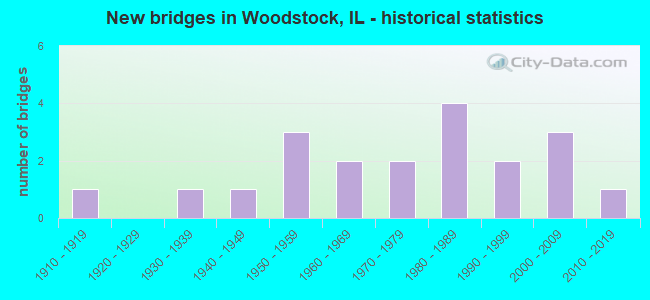
- New bridges - historical statistics
- 11910-1919
- 11930-1939
- 11940-1949
- 31950-1959
- 21960-1969
- 21970-1979
- 41980-1989
- 21990-1999
- 32000-2009
- 12010-2019

- Reconstructed bridges - Historical Statistics
- 21970-1979
- 01980-1989
- 01990-1999
- 22000-2009


- Bridge Condition - Deck
- 7.7%Excellent
- 15.4%Very good
- 7.7%Good
- 30.8%Satisfactory
- 7.7%Fair
- 23.1%Poor
- 7.7%Serious

- Bridge Condition - Superstructure
- 7.7%Excellent
- 23.1%Very good
- 30.8%Satisfactory
- 7.7%Fair
- 23.1%Poor
- 7.7%Serious

- Bridge Condition - Substructure
- 7.7%Excellent
- 38.5%Very good
- 30.8%Good
- 15.4%Fair
- 7.7%Serious

- Bridge Condition - Channel
- 6.3%Excellent
- 50.0%Very good
- 12.5%Good
- 25.0%Satisfactory
- 6.3%Fair

- Bridge Condition - Culverts
- 20.0%Very good
- 60.0%Satisfactory
- 20.0%Poor
Find on map >> Show street view
Structure Number: 560055, Location: 9.0 S OF STATE LINE (Lat: 42.369831, Lng: -88.443139), Route carried "on" structure: State highway 47, Year Built: 1985, Status: Open, Structure Length: 1.07m (3.51ft), Average Daily Traffic: 5,550 (year 2019), Truck Traffic: 12%, Average Future Daily Traffic: 5,240 (year 2032), Design Load: HS 20, Features Intersected: SILVER CREEK
Minimum Vertical Clearance: 30+ m (98+ ft), Kilometerpoint: 258.454, Lanes on structure: 2, Base Highway Network: Yes, Owner: State Highway Agency, Approaching Roadway Width: 7.9m (25.9ft), Skew: 4 degrees, Material/Design: Concrete continuous, Design/Construction: Culvert, Number Of Spans In Main Unit: 2, Length of Maximum Span: 5.2m (17.1ft)
Condition: Channel: Satisfactory, Culverts: Satisfactory, Operating Rating: 64.8 metric tons, Method Used To Determine Operating Rating: Load Factor (LF) rating reported by rating factor (RF) method using MS18 loading, Inventory Rating: 38.9 metric tons, Method Used To Determine Inventory Rating: Load Factor (LF) rating reported by rating factor (RF) method using MS18 loading, Structural Evaluation: Equal to present minimum criteria, Waterway Adequacy: Equal to present minimum criteria, Approach Roadway Alignment: Equal to present desirable criteria, Designated Inspection Frequency: Every 24 months, Inspection Date: June 2020
Find on map >> Show street view
Structure Number: 563006, Location: AT NELSON RD (Lat: 42.364931, Lng: -88.472861), Route carried "on" structure: County highway , Year Built: 1947, Year Reconstructed: 1984, Status: Open, Structure Length: 0.94m (3.08ft), Average Daily Traffic: 6,300 (year 2021), Truck Traffic: 9%, Average Future Daily Traffic: 7,861 (year 2032), Design Load: HS 20, Features Intersected: Slough Creek, Facility Carried by Structure: CHARLES RD
Minimum Vertical Clearance: 30+ m (98+ ft), Kilometerpoint: 16.238, Lanes on structure: 2, Owner: County Highway Agency, Approaching Roadway Width: 9.8m (32.2ft), Skew: 1 degrees, Material/Design: Prestressed concrete, Design/Construction: Box Beam or Girders - Multiple, Number Of Spans In Main Unit: 1, Length of Maximum Span: 9.4m (30.8ft), Curb-To-Curb Width: 12.2m (40.0ft), Out-to-Out Width: 12.2m (40.0ft)
Condition: Deck: Poor, Superstructure: Poor, Substructure: Fair, Channel: Very good, Operating Rating: 49.9 metric tons, Method Used To Determine Operating Rating: Load Factor (LF) rating reported by rating factor (RF) method using MS18 loading, Inventory Rating: 29.8 metric tons, Method Used To Determine Inventory Rating: Load Factor (LF) rating reported by rating factor (RF) method using MS18 loading, Structural Evaluation: Meets minimum limits, Deck Geometry: Somewhat better than minimum adequacy, Waterway Adequacy: Superior to present desirable criteria, Approach Roadway Alignment: Equal to present desirable criteria, Designated Inspection Frequency: Every 24 months, Inspection Date: October 2020, Deck Structure Type: Concrete Precast Panels, Wearing Surface/Protective System: Wearing Surface: Bituminous, Membrane: Built-up
Find on map >> Show street view
Structure Number: 563015, Location: 2.8 M W OF IL 47 (Lat: 42.305169, Lng: -88.470231), Route carried "on" structure: Other road , Year Built: 1958, Year Reconstructed: 2005, Status: Open, Structure Length: 5.84m (19.16ft), Average Daily Traffic: 3,600 (year 2021), Truck Traffic: 9%, Average Future Daily Traffic: 4,347 (year 2032), Design Load: HS 20, Features Intersected: US 14, Facility Carried by Structure: SOUTH STREET
Minimum Vertical Clearance: 30+ m (98+ ft), Kilometerpoint: 2.527, Lanes on structure: 2, Lanes under structure: 2, Base Highway Network: Yes, Owner: State Highway Agency, Approaching Roadway Width: 7.9m (25.9ft), Material/Design: Steel continuous, Design/Construction: Stringer/Multi-beam, Number Of Spans In Main Unit: 4, Length of Maximum Span: 16.8m (55.1ft), Curb-To-Curb Width: 7.9m (25.9ft), Out-to-Out Width: 10.6m (34.8ft)
Condition: Deck: Good, Superstructure: Very good, Substructure: Good, Operating Rating: 89.1 metric tons, Method Used To Determine Operating Rating: Load Factor (LF) rating reported by rating factor (RF) method using MS18 loading, Inventory Rating: 59.3 metric tons, Method Used To Determine Inventory Rating: Load Factor (LF) rating reported by rating factor (RF) method using MS18 loading, Structural Evaluation: Better than present minimum criteria, Deck Geometry: High priority of corrective action, Underclear: Meets minimum limits, Approach Roadway Alignment: Equal to present desirable criteria, Designated Inspection Frequency: Every 48 months, Inspection Date: August 2018, Deck Structure Type: Concrete Cast-file-Place, Wearing Surface/Protective System: Deck Protection: Epoxy Coated Reinforcing
Find on map >> Show street view
Structure Number: 563039, Location: .15 MI N NELSON RD (Lat: 42.365922, Lng: -88.501389), Route carried "on" structure: County highway , Year Built: 1968, Status: Posted for load, Structure Length: 0.75m (2.46ft), Average Daily Traffic: 225 (year 2021), Truck Traffic: 9%, Average Future Daily Traffic: 328 (year 2032), Features Intersected: SLOUGH CREEK, Facility Carried by Structure: MURRAY ROAD
Minimum Vertical Clearance: 30+ m (98+ ft), Kilometerpoint: 1.706, Lanes on structure: 2, Owner: Town or Township Highway Agency, Approaching Roadway Width: 7.3m (24.0ft), Skew: 2 degrees, Material/Design: Steel, Design/Construction: Culvert, Number Of Spans In Main Unit: 3, Length of Maximum Span: 2.0m (6.6ft)
Condition: Channel: Satisfactory, Culverts: Poor, Operating Rating: 24.0 metric tons, Method Used To Determine Operating Rating: Load Factor (LF) rating reported by rating factor (RF) method using MS18 loading, Inventory Rating: 14.3 metric tons, Method Used To Determine Inventory Rating: Load Factor (LF) rating reported by rating factor (RF) method using MS18 loading, Structural Evaluation: Meets minimum limits, Waterway Adequacy: Better than present minimum criteria, Approach Roadway Alignment: Equal to present desirable criteria, Bridge Posting: Required (Relationship of Operating Rating to Maximum Legal Load: > 39.9% below), Designated Inspection Frequency: Every 24 months, Inspection Date: September 2020
Find on map >> Show street view
Structure Number: 563046, Location: 0.7 MI N PERKINS RD (Lat: 42.286539, Lng: -88.476969), Route carried "on" structure: County highway , Year Built: 1919, Year Reconstructed: 1975, Status: Open, Structure Length: 0.80m (2.62ft), Average Daily Traffic: 425 (year 2021), Truck Traffic: 10%, Average Future Daily Traffic: 834 (year 2032), Features Intersected: APPLE CREEK, Facility Carried by Structure: STEIG ROAD
Minimum Vertical Clearance: 30+ m (98+ ft), Kilometerpoint: 1.400, Lanes on structure: 2, Owner: Town or Township Highway Agency, Approaching Roadway Width: 6.4m (21.0ft), Material/Design: Steel, Design/Construction: Culvert, Number Of Spans In Main Unit: 3, Length of Maximum Span: 2.1m (6.9ft)
Condition: Channel: Satisfactory, Culverts: Satisfactory, Operating Rating: 47.0 metric tons, Method Used To Determine Operating Rating: Load Factor (LF) rating reported by rating factor (RF) method using MS18 loading, Inventory Rating: 28.2 metric tons, Method Used To Determine Inventory Rating: Load Factor (LF) rating reported by rating factor (RF) method using MS18 loading, Structural Evaluation: Equal to present minimum criteria, Waterway Adequacy: Better than present minimum criteria, Approach Roadway Alignment: Equal to present desirable criteria, Designated Inspection Frequency: Every 24 months, Inspection Date: October 2020
Find on map >> Show street view
Structure Number: 563071, Location: 1.7 MI S OF STREIT R (Lat: 42.361550, Lng: -88.550181), Route carried "on" structure: County highway , Year Built: 1959, Status: Posted for load, Structure Length: 2.13m (6.99ft), Average Daily Traffic: 250 (year 2021), Truck Traffic: 14%, Average Future Daily Traffic: 179 (year 2032), Design Load: HS 15, Features Intersected: N BR KISHWAUKEE RIV, Facility Carried by Structure: PAULSEN RD
Minimum Vertical Clearance: 30+ m (98+ ft), Kilometerpoint: 2.655, Lanes on structure: 2, Owner: Town or Township Highway Agency, Approaching Roadway Width: 5.8m (19.0ft), Material/Design: Prestressed concrete, Design/Construction: Box Beam or Girders - Multiple, Number Of Spans In Main Unit: 2, Length of Maximum Span: 10.4m (34.1ft), Curb-To-Curb Width: 6.8m (22.3ft), Out-to-Out Width: 7.4m (24.3ft)
Condition: Deck: Fair, Superstructure: Fair, Substructure: Serious, Channel: Satisfactory, Operating Rating: 37.6 metric tons, Method Used To Determine Operating Rating: Allowable Stress (AS) rating reported by rating factor (RF) method using MS18 loading, Inventory Rating: 13.0 metric tons, Method Used To Determine Inventory Rating: Allowable Stress (AS) rating reported by rating factor (RF) method using MS18 loading, Structural Evaluation: High priority of corrective action, Deck Geometry: Meets minimum limits, Waterway Adequacy: Equal to present desirable criteria, Approach Roadway Alignment: Equal to present desirable criteria, Bridge Posting: Required (Relationship of Operating Rating to Maximum Legal Load: > 39.9% below), Designated Inspection Frequency: Every 24 months, Other Special Inspection Frequency: Every 12 months, Inspection Date: May 2020, Other Special Inspection Date: May 2021, Deck Structure Type: Concrete Precast Panels, Wearing Surface/Protective System: Wearing Surface: Bituminous
Find on map >> Show street view
Structure Number: 563116, Location: 0.7M W IL47 (Lat: 42.385125, Lng: -88.453683), Route carried "on" structure: County highway , Year Built: 1975, Year Reconstructed: 2012, Status: Open, Structure Length: 1.57m (5.15ft), Average Daily Traffic: 175 (year 2021), Truck Traffic: 9%, Average Future Daily Traffic: 298 (year 2032), Design Load: HS 20, Features Intersected: Slough Creek, Facility Carried by Structure: Jankowski Rd/ TR85
Minimum Vertical Clearance: 30+ m (98+ ft), Kilometerpoint: 2.317, Lanes on structure: 2, Owner: Town or Township Highway Agency, Approaching Roadway Width: 6.1m (20.0ft), Skew: 2 degrees, Material/Design: Prestressed concrete, Design/Construction: Box Beam or Girders - Multiple, Number Of Spans In Main Unit: 1, Length of Maximum Span: 14.7m (48.2ft), Curb-To-Curb Width: 8.2m (26.9ft), Out-to-Out Width: 8.2m (26.9ft)
Condition: Deck: Very good, Superstructure: Very good, Substructure: Very good, Channel: Good, Operating Rating: 44.1 metric tons, Method Used To Determine Operating Rating: Load and Resistance Factor Rating (LRFR) rating reported by rating factor(RF) method using HL-93 loadings, Inventory Rating: 35.0 metric tons, Method Used To Determine Inventory Rating: Load and Resistance Factor Rating (LRFR) rating reported by rating factor(RF) method using HL-93 loadings, Structural Evaluation: Equal to present desirable criteria, Deck Geometry: Somewhat better than minimum adequacy, Waterway Adequacy: Equal to present desirable criteria, Approach Roadway Alignment: Equal to present desirable criteria, Designated Inspection Frequency: Every 48 months, Inspection Date: October 2018, Deck Structure Type: Concrete Precast Panels, Wearing Surface/Protective System: Wearing Surface: Bituminous, Membrane: Built-up
Find on map >> Show street view
Structure Number: 563136, Location: 0.05 MI E FRANLINVIL (Lat: 42.276742, Lng: -88.510042), Route carried "on" structure: County highway , Year Built: 1980, Status: Open, Structure Length: 1.62m (5.31ft), Average Daily Traffic: 725 (year 2021), Truck Traffic: 8%, Average Future Daily Traffic: 953 (year 2032), Design Load: HS 20, Features Intersected: FRANKLINVILLE CR, Facility Carried by Structure: PERKINS RD
Minimum Vertical Clearance: 30+ m (98+ ft), Kilometerpoint: 2.848, Lanes on structure: 2, Owner: Town or Township Highway Agency, Approaching Roadway Width: 6.8m (22.3ft), Skew: 1 degrees, Material/Design: Prestressed concrete, Design/Construction: Box Beam or Girders - Multiple, Number Of Spans In Main Unit: 1, Length of Maximum Span: 15.8m (51.8ft), Curb-To-Curb Width: 9.1m (29.9ft), Out-to-Out Width: 9.1m (29.9ft)
Condition: Deck: Poor, Superstructure: Poor, Substructure: Good, Channel: Very good, Operating Rating: 37.3 metric tons, Method Used To Determine Operating Rating: Load Factor (LF) rating reported by rating factor (RF) method using MS18 loading, Inventory Rating: 18.8 metric tons, Method Used To Determine Inventory Rating: Load Factor (LF) rating reported by rating factor (RF) method using MS18 loading, Structural Evaluation: Meets minimum limits, Deck Geometry: Equal to present minimum criteria, Waterway Adequacy: Equal to present desirable criteria, Approach Roadway Alignment: Equal to present desirable criteria, Designated Inspection Frequency: Every 24 months, Inspection Date: October 2020, Deck Structure Type: Concrete Precast Panels, Wearing Surface/Protective System: Wearing Surface: Bituminous, Membrane: Built-up
Find on map >> Show street view
Structure Number: 563143, Location: 0.1MI E OF ROSE FM (Lat: 42.297914, Lng: -88.494489), Route carried "on" structure: Other road , Year Built: 1983, Status: Posted for load, Structure Length: 1.34m (4.40ft), Average Daily Traffic: 2,050 (year 2021), Truck Traffic: 5%, Average Future Daily Traffic: 4,347 (year 2032), Design Load: HS 20, Features Intersected: FRANKLINVILLE CR, Facility Carried by Structure: SOUTH ST RD
Minimum Vertical Clearance: 30+ m (98+ ft), Kilometerpoint: 0.161, Lanes on structure: 2, Owner: Town or Township Highway Agency, Approaching Roadway Width: 10.0m (32.8ft), Skew: 1 degrees, Material/Design: Prestressed concrete, Design/Construction: Box Beam or Girders - Multiple, Number Of Spans In Main Unit: 1, Length of Maximum Span: 13.1m (43.0ft), Curb-To-Curb Width: 12.2m (40.0ft), Out-to-Out Width: 12.2m (40.0ft)
Condition: Deck: Serious, Superstructure: Serious, Substructure: Very good, Channel: Very good, Operating Rating: 36.3 metric tons, Method Used To Determine Operating Rating: Load Factor (LF) rating reported by rating factor (RF) method using MS18 loading, Inventory Rating: 21.7 metric tons, Method Used To Determine Inventory Rating: Load Factor (LF) rating reported by rating factor (RF) method using MS18 loading, Structural Evaluation: High priority of corrective action, Deck Geometry: Equal to present minimum criteria, Waterway Adequacy: Superior to present desirable criteria, Approach Roadway Alignment: Equal to present desirable criteria, Bridge Posting: Required (Relationship of Operating Rating to Maximum Legal Load: 30.0 - 39.9% below), Designated Inspection Frequency: Every 24 months, Inspection Date: October 2020, Deck Structure Type: Concrete Precast Panels, Wearing Surface/Protective System: Wearing Surface: Bituminous, Membrane: Built-up
Find on map >> Show street view
Structure Number: 563153, Location: 4.6M.W.OF WOODSTOCK (Lat: 42.298450, Lng: -88.542294), Route carried "on" structure: County highway , Year Built: 1991, Status: Open, Structure Length: 4.03m (13.22ft), Average Daily Traffic: 725 (year 2021), Truck Traffic: 4%, Average Future Daily Traffic: 1,370 (year 2032), Design Load: HS 20, Features Intersected: N.BR.KISHWAUKEE RIV., Facility Carried by Structure: COLLINS RD.
Minimum Vertical Clearance: 30+ m (98+ ft), Kilometerpoint: 5.488, Lanes on structure: 2, Owner: Town or Township Highway Agency, Approaching Roadway Width: 6.1m (20.0ft), Material/Design: Prestressed concrete, Design/Construction: Box Beam or Girders - Multiple, Number Of Spans In Main Unit: 3, Length of Maximum Span: 16.5m (54.1ft), Curb-To-Curb Width: 8.2m (26.9ft), Out-to-Out Width: 8.2m (26.9ft)
Condition: Deck: Satisfactory, Superstructure: Satisfactory, Substructure: Good, Channel: Very good, Operating Rating: 56.7 metric tons, Method Used To Determine Operating Rating: Load Factor (LF) rating reported by rating factor (RF) method using MS18 loading, Inventory Rating: 33.4 metric tons, Method Used To Determine Inventory Rating: Load Factor (LF) rating reported by rating factor (RF) method using MS18 loading, Structural Evaluation: Equal to present minimum criteria, Deck Geometry: Somewhat better than minimum adequacy, Waterway Adequacy: Equal to present desirable criteria, Approach Roadway Alignment: Equal to present desirable criteria, Designated Inspection Frequency: Every 24 months, Inspection Date: October 2020, Deck Structure Type: Concrete Precast Panels, Wearing Surface/Protective System: Wearing Surface: Bituminous, Membrane: Built-up
Find on map >> Show street view
Structure Number: 563161, Location: 1.2MI W ALDEN RD (Lat: 42.399886, Lng: -88.523258), Route carried "on" structure: County highway , Year Built: 1996, Status: Open, Structure Length: 3.29m (10.79ft), Average Daily Traffic: 2,400 (year 2021), Truck Traffic: 15%, Average Future Daily Traffic: 2,858 (year 2032), Design Load: HS 20, Features Intersected: N.BR. KISHAWAUKEE, Facility Carried by Structure: MCGUIRE RD
Minimum Vertical Clearance: 30+ m (98+ ft), Kilometerpoint: 6.872, Lanes on structure: 2, Owner: County Highway Agency, Approaching Roadway Width: 7.3m (24.0ft), Material/Design: Prestressed concrete, Design/Construction: Box Beam or Girders - Multiple, Number Of Spans In Main Unit: 2, Length of Maximum Span: 18.8m (61.7ft), Curb-To-Curb Width: 11.0m (36.1ft), Out-to-Out Width: 11.0m (36.1ft)
Condition: Deck: Satisfactory, Superstructure: Satisfactory, Substructure: Very good, Channel: Very good, Operating Rating: 51.8 metric tons, Method Used To Determine Operating Rating: Load Factor (LF) rating reported by rating factor (RF) method using MS18 loading, Inventory Rating: 31.1 metric tons, Method Used To Determine Inventory Rating: Load Factor (LF) rating reported by rating factor (RF) method using MS18 loading, Structural Evaluation: Equal to present minimum criteria, Deck Geometry: Somewhat better than minimum adequacy, Waterway Adequacy: Superior to present desirable criteria, Approach Roadway Alignment: Equal to present desirable criteria, Designated Inspection Frequency: Every 24 months, Inspection Date: September 2020, Deck Structure Type: Concrete Precast Panels, Wearing Surface/Protective System: Wearing Surface: Bituminous, Membrane: Built-up
Find on map >> Show street view
Structure Number: 563162, Location: .7M N OF NELSON RD (Lat: 42.375656, Lng: -88.522475), Route carried "on" structure: County highway , Year Built: 2004, Status: Open, Structure Length: 5.08m (16.67ft), Average Daily Traffic: 100 (year 2017), Truck Traffic: 25%, Average Future Daily Traffic: 89 (year 2032), Design Load: HS 20, Features Intersected: UNION PACIFIC RR, Facility Carried by Structure: DEEP CUT ROAD
Minimum Vertical Clearance: 30+ m (98+ ft), Kilometerpoint: 1.143, Lanes on structure: 2, Owner: Town or Township Highway Agency, Approaching Roadway Width: 7.3m (24.0ft), Skew: 1 degrees, Material/Design: Prestressed concrete, Design/Construction: Box Beam or Girders - Multiple, Number Of Spans In Main Unit: 3, Length of Maximum Span: 19.5m (64.0ft), Curb-To-Curb Width: 9.1m (29.9ft), Out-to-Out Width: 9.8m (32.2ft)
Condition: Deck: Satisfactory, Superstructure: Satisfactory, Substructure: Fair, Operating Rating: 71.0 metric tons, Method Used To Determine Operating Rating: Load Factor (LF) rating reported by rating factor (RF) method using MS18 loading, Inventory Rating: 42.4 metric tons, Method Used To Determine Inventory Rating: Load Factor (LF) rating reported by rating factor (RF) method using MS18 loading, Structural Evaluation: Somewhat better than minimum adequacy, Deck Geometry: Better than present minimum criteria, Underclear: Equal to present desirable criteria, Approach Roadway Alignment: Equal to present desirable criteria, Designated Inspection Frequency: Every 24 months, Inspection Date: September 2020, Deck Structure Type: Concrete Precast Panels, Wearing Surface/Protective System: Wearing Surface: Bituminous, Membrane: Built-up
Find on map >> Show street view
Structure Number: 563168, Location: 0.3 M SO US-14 (Lat: 42.271464, Lng: -88.398853), Route carried "on" structure: County highway , Year Built: 2000, Status: Open, Structure Length: 2.39m (7.84ft), Average Daily Traffic: 1,700 (year 2021), Truck Traffic: 11%, Average Future Daily Traffic: 1,965 (year 2032), Design Load: HS 20, Features Intersected: KISHWAUKEE RIVER, Facility Carried by Structure: DOTY RD
Minimum Vertical Clearance: 30+ m (98+ ft), Kilometerpoint: 0.612, Lanes on structure: 2, Owner: Town or Township Highway Agency, Approaching Roadway Width: 9.1m (29.9ft), Skew: 2 degrees, Material/Design: Prestressed concrete, Design/Construction: Box Beam or Girders - Multiple, Number Of Spans In Main Unit: 1, Length of Maximum Span: 23.1m (75.8ft), Curb-To-Curb Width: 9.1m (29.9ft), Out-to-Out Width: 9.1m (29.9ft)
Condition: Deck: Satisfactory, Superstructure: Satisfactory, Substructure: Very good, Channel: Very good, Operating Rating: 73.9 metric tons, Method Used To Determine Operating Rating: Load Factor (LF) rating reported by rating factor (RF) method using MS18 loading, Inventory Rating: 41.5 metric tons, Method Used To Determine Inventory Rating: Load Factor (LF) rating reported by rating factor (RF) method using MS18 loading, Structural Evaluation: Equal to present minimum criteria, Deck Geometry: Somewhat better than minimum adequacy, Waterway Adequacy: Superior to present desirable criteria, Approach Roadway Alignment: Equal to present desirable criteria, Designated Inspection Frequency: Every 24 months, Inspection Date: October 2020, Deck Structure Type: Concrete Precast Panels, Wearing Surface/Protective System: Wearing Surface: Bituminous, Membrane: Built-up
Find on map >> Show street view
Structure Number: 563171, Location: 3.5 MI E OF US 14 (Lat: 42.385431, Lng: -88.524869), Route carried "on" structure: County highway , Year Built: 2007, Status: Open, Structure Length: 2.16m (7.09ft), Average Daily Traffic: 100 (year 2021), Truck Traffic: 13%, Average Future Daily Traffic: 179 (year 2032), Design Load: HS 20, Features Intersected: NO BR KISHWAUKEE R, Facility Carried by Structure: STREIT RD
Minimum Vertical Clearance: 30+ m (98+ ft), Kilometerpoint: 11.024, Lanes on structure: 2, Owner: Town or Township Highway Agency, Approaching Roadway Width: 9.8m (32.2ft), Material/Design: Prestressed concrete, Design/Construction: Box Beam or Girders - Multiple, Number Of Spans In Main Unit: 1, Length of Maximum Span: 20.9m (68.6ft), Curb-To-Curb Width: 10.1m (33.1ft), Out-to-Out Width: 10.1m (33.1ft)
Condition: Deck: Very good, Superstructure: Very good, Substructure: Very good, Channel: Very good, Operating Rating: 61.6 metric tons, Method Used To Determine Operating Rating: Load Factor (LF) rating reported by rating factor (RF) method using MS18 loading, Inventory Rating: 36.9 metric tons, Method Used To Determine Inventory Rating: Load Factor (LF) rating reported by rating factor (RF) method using MS18 loading, Structural Evaluation: Equal to present desirable criteria, Deck Geometry: Superior to present desirable criteria, Waterway Adequacy: Superior to present desirable criteria, Approach Roadway Alignment: Equal to present desirable criteria, Designated Inspection Frequency: Every 48 months, Inspection Date: October 2018, Deck Structure Type: Concrete Precast Panels, Wearing Surface/Protective System: Wearing Surface: Integral Concrete
Find on map >> Show street view
Structure Number: 563195, Location: 0.1 MI S PERKINS RD (Lat: 42.275839, Lng: -88.511019), Route carried "on" structure: County highway , Year Built: 2016, Status: Open, Structure Length: 1.97m (6.46ft), Average Daily Traffic: 1,500 (year 2021), Truck Traffic: 12%, Average Future Daily Traffic: 1,800 (year 2041), Design Load: HS 25 or greater, Features Intersected: TRIB KISH RIVER, Facility Carried by Structure: FRANKLINVILLE RD
Minimum Vertical Clearance: 30+ m (98+ ft), Kilometerpoint: 3.717, Lanes on structure: 2, Owner: County Highway Agency, Approaching Roadway Width: 9.8m (32.2ft), Skew: 1 degrees, Material/Design: Concrete continuous, Design/Construction: Slab, Number Of Spans In Main Unit: 2, Length of Maximum Span: 9.4m (30.8ft), Curb-To-Curb Width: 9.8m (32.2ft), Out-to-Out Width: 9.8m (32.2ft)
Condition: Deck: Excellent, Superstructure: Excellent, Substructure: Excellent, Channel: Excellent, Operating Rating: 46.7 metric tons, Method Used To Determine Operating Rating: Load and Resistance Factor Rating (LRFR) rating reported by rating factor(RF) method using HL-93 loadings, Inventory Rating: 36.3 metric tons, Method Used To Determine Inventory Rating: Load and Resistance Factor Rating (LRFR) rating reported by rating factor(RF) method using HL-93 loadings, Structural Evaluation: Superior to present desirable criteria, Deck Geometry: Somewhat better than minimum adequacy, Waterway Adequacy: Equal to present desirable criteria, Approach Roadway Alignment: Equal to present desirable criteria, Designated Inspection Frequency: Every 48 months, Inspection Date: July 2018, Deck Structure Type: Concrete Cast-file-Place, Wearing Surface/Protective System: Deck Protection: Epoxy Coated Reinforcing
Find on map >> Show street view
Structure Number: 563201, Location: 0.05 MI E MURRAY RD (Lat: 42.363464, Lng: -88.500825), Route carried "on" structure: County highway , Year Built: 1963, Status: Open, Structure Length: 0.79m (2.59ft), Average Daily Traffic: 1,800 (year 2021), Truck Traffic: 9%, Average Future Daily Traffic: 655 (year 2032), Design Load: HS 20, Features Intersected: Slough Creek, Facility Carried by Structure: NELSON ROAD
Minimum Vertical Clearance: 30+ m (98+ ft), Kilometerpoint: 4.747, Lanes on structure: 2, Owner: County Highway Agency, Approaching Roadway Width: 9.1m (29.9ft), Skew: 2 degrees, Material/Design: Concrete, Design/Construction: Culvert, Number Of Spans In Main Unit: 2, Length of Maximum Span: 3.7m (12.1ft), Curb-To-Curb Width: 6.7m (22.0ft), Out-to-Out Width: 23.1m (75.8ft)
Condition: Channel: Fair, Culverts: Satisfactory, Operating Rating: 88.8 metric tons, Method Used To Determine Operating Rating: Load Factor (LF) rating reported by rating factor (RF) method using MS18 loading, Inventory Rating: 63.2 metric tons, Method Used To Determine Inventory Rating: Load Factor (LF) rating reported by rating factor (RF) method using MS18 loading, Structural Evaluation: Equal to present minimum criteria, Deck Geometry: High priority of corrective action, Waterway Adequacy: Equal to present desirable criteria, Approach Roadway Alignment: Equal to present desirable criteria, Designated Inspection Frequency: Every 24 months, Inspection Date: September 2020, Deck Structure Type: Other
Find on map >> Show street view
Structure Number: 563211, Location: 0.6 M NW OF ILL 47 (Lat: 42.361078, Lng: -88.455525), Route carried "on" structure: County highway , Year Built: 1978, Status: Open, Structure Length: 0.67m (2.20ft), Average Daily Traffic: 6,500 (year 2021), Truck Traffic: 8%, Average Future Daily Traffic: 7,146 (year 2032), Design Load: HS 20, Features Intersected: SILVER CR, Facility Carried by Structure: CHARLES RD
Minimum Vertical Clearance: 30+ m (98+ ft), Kilometerpoint: 17.751, Lanes on structure: 2, Owner: County Highway Agency, Approaching Roadway Width: 9.1m (29.9ft), Material/Design: Concrete, Design/Construction: Culvert, Number Of Spans In Main Unit: 2, Length of Maximum Span: 3.0m (9.8ft), Curb-To-Curb Width: 12.2m (40.0ft), Out-to-Out Width: 15.3m (50.2ft)
Condition: Channel: Good, Culverts: Very good, Operating Rating: 53.8 metric tons, Method Used To Determine Operating Rating: Assigned rating based on Load Factor Design (LFD) reported by rating factor (RF) using MS18 loading, Inventory Rating: 32.4 metric tons, Method Used To Determine Inventory Rating: Assigned rating based on Load Factor Design (LFD) reported by rating factor (RF) using MS18 loading, Structural Evaluation: Equal to present desirable criteria, Deck Geometry: Somewhat better than minimum adequacy, Waterway Adequacy: Superior to present desirable criteria, Approach Roadway Alignment: Equal to present desirable criteria, Designated Inspection Frequency: Every 48 months, Inspection Date: October 2018
Find on map >> Show street view
Structure Number: 566951, Location: 0.09M.W. OFIL-47 (Lat: 42.337792, Lng: -88.445589), Route carried "on" structure: Other road , Year Built: 1984, Status: Open, Structure Length: 0.91m (2.99ft), Average Daily Traffic: 1,050 (year 2021), Truck Traffic: 6%, Average Future Daily Traffic: 1,131 (year 2032), Design Load: HS 20, Features Intersected: SILVER CREEK, Facility Carried by Structure: MELODY LANE
Minimum Vertical Clearance: 30+ m (98+ ft), Kilometerpoint: 0.193, Lanes on structure: 2, Owner: City or Municipal Highway Agency, Approaching Roadway Width: 10.1m (33.1ft), Material/Design: Prestressed concrete, Design/Construction: Box Beam or Girders - Multiple, Number Of Spans In Main Unit: 1, Length of Maximum Span: 8.5m (27.9ft), Curb or Sidewalk Widths: Left: 1.2m (3.9ft), Right: 1.2m (3.9ft), Curb-To-Curb Width: 9.1m (29.9ft), Out-to-Out Width: 12.2m (40.0ft)
Condition: Deck: Poor, Superstructure: Poor, Substructure: Good, Channel: Very good, Operating Rating: 58.0 metric tons, Method Used To Determine Operating Rating: Load Factor (LF) rating reported by rating factor (RF) method using MS18 loading, Inventory Rating: 22.0 metric tons, Method Used To Determine Inventory Rating: Load Factor (LF) rating reported by rating factor (RF) method using MS18 loading, Structural Evaluation: Meets minimum limits, Deck Geometry: Somewhat better than minimum adequacy, Waterway Adequacy: Equal to present desirable criteria, Approach Roadway Alignment: Equal to present desirable criteria, Designated Inspection Frequency: Every 24 months, Other Special Inspection Frequency: Every 12 months, Inspection Date: Febuary 2021, Other Special Inspection Date: Febuary 2021, Deck Structure Type: Concrete Precast Panels, Wearing Surface/Protective System: Wearing Surface: Bituminous, Membrane: Built-up
Find on map >> Show street view
Structure Number: 560044, Location: ILL 47 WOODSTOCK (Lat: 42.304942, Lng: -88.432067), Route carried "under" structure: State highway 47, Year Built: 1936, Structure Length: 0. m, Average Daily Traffic: 13,600 (year 2019), Truck Traffic: 5%, Features Intersected: ILL 47, Facility Carried by Structure: CHIGO NORTH WESTER
Minimum Vertical Clearance: 4.39m (14.40ft), Kilometerpoint: 250.890, Lanes under structure: 2, Material/Design: Steel, Design/Construction: Girder and Floorbeam System, Length of Maximum Span: 19.8m (65.0ft)
Find on map >> Show street view
Structure Number: 563015, Location: 2.8 M W OF IL 47 (Lat: 42.305169, Lng: -88.470231), Route carried "under" structure: US 14, Year Built: 1958, Structure Length: 0. m, Average Daily Traffic: 13,100 (year 2021), Truck Traffic: 6%, Features Intersected: US 14, Facility Carried by Structure: SOUTH STREET
Minimum Vertical Clearance: 4.60m (15.09ft), Kilometerpoint: 28.163, Lanes on structure: 2, Lanes under structure: 2, Material/Design: Steel continuous, Design/Construction: Stringer/Multi-beam, Length of Maximum Span: 16.8m (55.1ft)