Bridge Statistics for Woodlawn, Maryland (MD)
Condition, Traffic, Stress, Structural Evaluation, Project Costs
- National Bridge Inventory (NBI) Statistics
- 35Number of bridges
- 151ft / 46.0mTotal length
- $4,157,000Total costs
- 1,812,512Total average daily traffic
- 66,807Total average daily truck traffic
- National Bridge Inventory (NBI) Registered Bridges for Woodlawn
- No street view available for this location
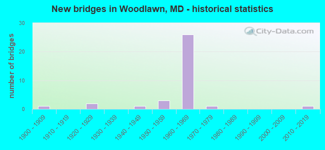
- New bridges - historical statistics
- 11900-1909
- 21920-1929
- 11940-1949
- 31950-1959
- 261960-1969
- 11970-1979
- 12010-2019

- Reconstructed bridges - Historical Statistics
- 11930-1939
- 01940-1949
- 01950-1959
- 21960-1969
- 21970-1979


- Bridge Condition - Deck
- 11.1%Very good
- 44.4%Satisfactory
- 33.3%Fair
- 11.1%Poor

- Bridge Condition - Superstructure
- 10.0%Very good
- 40.0%Satisfactory
- 40.0%Fair
- 10.0%Poor

- Bridge Condition - Substructure
- 10.0%Very good
- 40.0%Satisfactory
- 40.0%Fair
- 10.0%Poor

- Bridge Condition - Channel
- 38.5%Good
- 53.8%Satisfactory
- 7.7%Fair

- Bridge Condition - Culverts
- 66.7%Satisfactory
- 16.7%Fair
- 16.7%Poor
Find on map >> Show street view
Structure Number: 10000003006701, Location: 0.29 MI W OF BALT CITY (Lat: 39.324753, Lng: -76.714869), Route carried "on" structure: County highway 8018, Year Built: 1900, Year Reconstructed: 1937, Status: Open, Structure Length: 2.62m (8.60ft), Average Daily Traffic: 20,280 (year 2009), Truck Traffic: 8%, Average Future Daily Traffic: 24,814 (year 2026), Design Load: H 20, Features Intersected: GWYNNS FALLS, Facility Carried by Structure: GWYNN OAK AVENUE
Minimum Vertical Clearance: 30+ m (98+ ft), Kilometerpoint: 1.287, Lanes on structure: 4, Owner: State Highway Agency, Approaching Roadway Width: 20.7m (67.9ft), Skew: 20 degrees, Material/Design: Concrete, Design/Construction: Arch - Deck, Number Of Spans In Main Unit: 2, Length of Maximum Span: 12.5m (41.0ft), Curb or Sidewalk Widths: Left: 1.9m (6.2ft), Right: 1.9m (6.2ft), Curb-To-Curb Width: 21.0m (68.9ft), Out-to-Out Width: 25.3m (83.0ft)
Condition: Deck: Satisfactory, Superstructure: Fair, Substructure: Fair, Channel: Good, Operating Rating: 57.1 metric tons, Method Used To Determine Operating Rating: Allowable Stress (AS), Inventory Rating: 32.7 metric tons, Method Used To Determine Inventory Rating: Allowable Stress (AS), Structural Evaluation: Somewhat better than minimum adequacy, Deck Geometry: Superior to present desirable criteria, Waterway Adequacy: Equal to present minimum criteria, Approach Roadway Alignment: Equal to present minimum criteria, Length Of Structure Improvement: 2.62m (8.60ft), Designated Inspection Frequency: Every 24 months, Inspection Date: March 2021, Bridge Improvement Cost: $429,000, Roadway Improvement Cost: $43,000, Total Project Cost: $472,000, Deck Structure Type: Concrete Cast-file-Place, Wearing Surface/Protective System: Wearing Surface: Bituminous
Find on map >> Show street view
Structure Number: 100000030129013, Location: 2.89 MI E OF HOWARD CO (Lat: 39.305306, Lng: -76.743308), Route carried "on" structure: Ramp Interstate 70, Year Built: 1966, Year Reconstructed: 1973, Status: Open, Structure Length: 9.08m (29.79ft), Average Daily Traffic: 25,300 (year 2009), Truck Traffic: 8%, Average Future Daily Traffic: 31,180 (year 2029), Design Load: HS 20, Features Intersected: IS 695
Minimum Vertical Clearance: 4.88m (16.01ft), Kilometerpoint: 0.492, Lanes on structure: 1, Lanes under structure: 6, Base Highway Network: Yes, Owner: State Highway Agency, Approaching Roadway Width: 11.0m (36.1ft), Skew: 5 degrees, Material/Design: Steel, Design/Construction: Stringer/Multi-beam, Number Of Spans In Main Unit: 4, Length of Maximum Span: 27.1m (88.9ft), Curb-To-Curb Width: 6.1m (20.0ft), Out-to-Out Width: 7.8m (25.6ft)
Condition: Deck: Fair, Superstructure: Satisfactory, Substructure: Satisfactory, Inventory Rating: 54.4 metric tons, Method Used To Determine Inventory Rating: Load Factor (LF), Structural Evaluation: Equal to present minimum criteria, Deck Geometry: Somewhat better than minimum adequacy, Underclear: Meets minimum limits, Approach Roadway Alignment: Equal to present desirable criteria, Designated Inspection Frequency: Every 24 months, Inspection Date: June 2021, Deck Structure Type: Concrete Cast-file-Place, Wearing Surface/Protective System: Wearing Surface: Latex Concrete, Deck Protection: Other
Find on map >> Show street view
Structure Number: 100000030129014, Location: 2.89 MI E OF HOWARD CO (Lat: 39.306486, Lng: -76.744567), Route carried "on" structure: Ramp Interstate 70, Year Built: 1966, Year Reconstructed: 1973, Status: Open, Structure Length: 9.08m (29.79ft), Average Daily Traffic: 25,300 (year 2009), Truck Traffic: 8%, Average Future Daily Traffic: 31,180 (year 2029), Design Load: HS 20, Features Intersected: IS 695
Minimum Vertical Clearance: 4.88m (16.01ft), Kilometerpoint: 0.393, Lanes on structure: 1, Lanes under structure: 6, Base Highway Network: Yes, Owner: State Highway Agency, Approaching Roadway Width: 11.0m (36.1ft), Skew: 5 degrees, Material/Design: Steel, Design/Construction: Stringer/Multi-beam, Number Of Spans In Main Unit: 4, Length of Maximum Span: 27.1m (88.9ft), Curb-To-Curb Width: 6.1m (20.0ft), Out-to-Out Width: 7.8m (25.6ft)
Condition: Deck: Satisfactory, Superstructure: Satisfactory, Substructure: Satisfactory, Inventory Rating: 54.4 metric tons, Method Used To Determine Inventory Rating: Load Factor (LF), Structural Evaluation: Equal to present minimum criteria, Deck Geometry: Somewhat better than minimum adequacy, Underclear: Meets minimum limits, Approach Roadway Alignment: Equal to present desirable criteria, Designated Inspection Frequency: Every 24 months, Inspection Date: June 2021, Deck Structure Type: Concrete Cast-file-Place, Wearing Surface/Protective System: Wearing Surface: Latex Concrete, Deck Protection: Other
Find on map >> Show street view
Structure Number: 10000003013701, Location: 1.12 MILE NORTH OF IS 70 (Lat: 39.321794, Lng: -76.744544), Route carried "on" structure: Interstate 695, Year Built: 1961, Year Reconstructed: 1979, Status: Open, Structure Length: 3.29m (10.79ft), Average Daily Traffic: 203,902 (year 2009), Truck Traffic: 8%, Average Future Daily Traffic: 223,400 (year 2026), Design Load: HS 20, Features Intersected: DOGWOOD RD
Minimum Vertical Clearance: 30+ m (98+ ft), Kilometerpoint: 13.372, Lanes on structure: 8, Lanes under structure: 2, Base Highway Network: Yes, Owner: State Highway Agency, Approaching Roadway Width: 44.5m (146.0ft), Skew: 20 degrees, Material/Design: Steel, Design/Construction: Stringer/Multi-beam, Number Of Spans In Main Unit: 3, Length of Maximum Span: 15.5m (50.9ft), Curb-To-Curb Width: 45.7m (149.9ft), Out-to-Out Width: 47.4m (155.5ft)
Condition: Deck: Fair, Superstructure: Satisfactory, Substructure: Satisfactory, Operating Rating: 66.7 metric tons, Method Used To Determine Operating Rating: Load Factor (LF), Inventory Rating: 39.9 metric tons, Method Used To Determine Inventory Rating: Load Factor (LF), Structural Evaluation: Equal to present minimum criteria, Deck Geometry: Superior to present desirable criteria, Underclear: Meets minimum limits, Approach Roadway Alignment: Equal to present desirable criteria, Designated Inspection Frequency: Every 24 months, Inspection Date: December 2020, Deck Structure Type: Concrete Cast-file-Place, Wearing Surface/Protective System: Wearing Surface: Latex Concrete
Find on map >> Show street view
Structure Number: 200000B-006301, Location: 50 FT E SECURITY BLVD (Lat: 39.311183, Lng: -76.716794), Route carried "on" structure: County highway 2454, Year Built: 1948, Year Reconstructed: 1978, Status: Open, Structure Length: 1.34m (4.40ft), Average Daily Traffic: 11,216 (year 2021), Truck Traffic: 5%, Average Future Daily Traffic: 19,448 (year 2041), Design Load: HS 20, Features Intersected: DEAD RUN, Facility Carried by Structure: KERNAN DRIVE
Minimum Vertical Clearance: 30+ m (98+ ft), Kilometerpoint: 0.451, Lanes on structure: 2, Owner: County Highway Agency, Approaching Roadway Width: 8.5m (27.9ft), Skew: 1 degrees, Material/Design: Steel, Design/Construction: Stringer/Multi-beam, Number Of Spans In Main Unit: 1, Length of Maximum Span: 12.5m (41.0ft), Curb or Sidewalk Widths: Left: 1.8m (5.9ft), Right: 1.8m (5.9ft), Curb-To-Curb Width: 9.1m (29.9ft), Out-to-Out Width: 13.4m (44.0ft)
Condition: Deck: Satisfactory, Superstructure: Fair, Substructure: Fair, Channel: Satisfactory, Operating Rating: 45.4 metric tons, Method Used To Determine Operating Rating: Load Factor (LF), Inventory Rating: 27.2 metric tons, Method Used To Determine Inventory Rating: Load Factor (LF), Structural Evaluation: Somewhat better than minimum adequacy, Deck Geometry: High priority of corrective action, Waterway Adequacy: Equal to present minimum criteria, Approach Roadway Alignment: Equal to present desirable criteria, Designated Inspection Frequency: Every 12 months, Inspection Date: June 2021, Deck Structure Type: Concrete Cast-file-Place, Wearing Surface/Protective System: Wearing Surface: Integral Concrete, Deck Protection: Epoxy Coated Reinforcing
Find on map >> Show street view
Structure Number: 200000B-007201, Location: 200' SW OF HOLLOFIELD RD (Lat: 39.315861, Lng: -76.793500), Route carried "on" structure: County highway 2356, Year Built: 1929, Status: Posted for load, Structure Length: 2.32m (7.61ft), Average Daily Traffic: 2,221 (year 2018), Truck Traffic: 5%, Average Future Daily Traffic: 4,442 (year 2038), Features Intersected: DOGWOOD RUN, Facility Carried by Structure: DOGWOOD ROAD
Minimum Vertical Clearance: 30+ m (98+ ft), Kilometerpoint: 4.779, Lanes on structure: 2, Owner: County Highway Agency, Approaching Roadway Width: 6.1m (20.0ft), Material/Design: Concrete, Design/Construction: Arch - Deck, Number Of Spans In Main Unit: 1, Length of Maximum Span: 22.6m (74.1ft), Curb-To-Curb Width: 6.3m (20.7ft), Out-to-Out Width: 7.0m (23.0ft)
Condition: Deck: Poor, Superstructure: Poor, Substructure: Poor, Channel: Satisfactory, Operating Rating: 13.6 metric tons, Method Used To Determine Operating Rating: Field evaluation and documented engineering judgment, Inventory Rating: 13.6 metric tons, Method Used To Determine Inventory Rating: Field evaluation and documented engineering judgment, Structural Evaluation: Meets minimum limits, Deck Geometry: High priority of replacement, Waterway Adequacy: Superior to present desirable criteria, Approach Roadway Alignment: Equal to present minimum criteria, Bridge Posting: Required (Relationship of Operating Rating to Maximum Legal Load: > 39.9% below), Length Of Structure Improvement: 5.36m (17.59ft), Designated Inspection Frequency: Every 12 months, Inspection Date: July 2021, Bridge Improvement Cost: $1,536,000, Roadway Improvement Cost: $150,000, Total Project Cost: $1,686,000 ( Estimate for 2019), Deck Structure Type: Concrete Cast-file-Place, Wearing Surface/Protective System: Wearing Surface: Bituminous
Find on map >> Show street view
Structure Number: 200000B-009501, Location: 250 FT W DOGWOOD RD (Lat: 39.313267, Lng: -76.725658), Route carried "on" structure: County highway 2468, Year Built: 1952, Status: Open, Structure Length: 1.43m (4.69ft), Average Daily Traffic: 743 (year 2019), Truck Traffic: 5%, Average Future Daily Traffic: 1,769 (year 2039), Design Load: H 20, Features Intersected: DEAD RUN, Facility Carried by Structure: LITTLE CREEK DRIVE
Minimum Vertical Clearance: 30+ m (98+ ft), Kilometerpoint: 0.048, Lanes on structure: 2, Owner: County Highway Agency, Approaching Roadway Width: 11.0m (36.1ft), Material/Design: Steel, Design/Construction: Stringer/Multi-beam, Number Of Spans In Main Unit: 1, Length of Maximum Span: 13.4m (44.0ft), Curb or Sidewalk Widths: Left: 1.5m (4.9ft), Right: 1.5m (4.9ft), Curb-To-Curb Width: 11.0m (36.1ft), Out-to-Out Width: 14.6m (47.9ft)
Condition: Deck: Fair, Superstructure: Satisfactory, Substructure: Satisfactory, Channel: Fair, Operating Rating: 45.8 metric tons, Method Used To Determine Operating Rating: Load Factor (LF), Inventory Rating: 27.2 metric tons, Method Used To Determine Inventory Rating: Load Factor (LF), Structural Evaluation: Equal to present minimum criteria, Deck Geometry: Better than present minimum criteria, Waterway Adequacy: Equal to present minimum criteria, Approach Roadway Alignment: Equal to present desirable criteria, Designated Inspection Frequency: Every 24 months, Inspection Date: July 2021, Deck Structure Type: Concrete Cast-file-Place, Wearing Surface/Protective System: Wearing Surface: Monolithic Concrete
Find on map >> Show street view
Structure Number: 200000B-009601, Location: 200 FT E SECURITY BLVD (Lat: 39.303722, Lng: -76.712417), Route carried "on" structure: County highway 3327, Year Built: 1928, Status: Posted for load, Structure Length: 2.29m (7.51ft), Average Daily Traffic: 7,900 (year 2021), Truck Traffic: 5%, Average Future Daily Traffic: 12,300 (year 2041), Features Intersected: DEAD RUN, Facility Carried by Structure: OLD INGLESIDE AVE
Minimum Vertical Clearance: 30+ m (98+ ft), Kilometerpoint: 0.048, Lanes on structure: 1, Owner: County Highway Agency, Approaching Roadway Width: 6.7m (22.0ft), Material/Design: Concrete, Design/Construction: Arch - Deck, Number Of Spans In Main Unit: 2, Length of Maximum Span: 10.7m (35.1ft), Curb or Sidewalk Widths: Left: 1.3m (4.3ft), Right: 2.4m (7.9ft), Curb-To-Curb Width: 4.9m (16.1ft), Out-to-Out Width: 9.4m (30.8ft)
Condition: Superstructure: Fair, Substructure: Fair, Channel: Satisfactory, Operating Rating: 8.2 metric tons, Method Used To Determine Operating Rating: Load Factor (LF), Inventory Rating: 5.0 metric tons, Method Used To Determine Inventory Rating: Load Factor (LF), Structural Evaluation: High priority of replacement, Deck Geometry: High priority of replacement, Waterway Adequacy: Equal to present desirable criteria, Approach Roadway Alignment: Equal to present minimum criteria, Bridge Posting: Required (Relationship of Operating Rating to Maximum Legal Load: > 39.9% below), Length Of Structure Improvement: 3.20m (10.50ft), Designated Inspection Frequency: Every 24 months, Other Special Inspection Frequency: Every 12 months, Inspection Date: November 2021, Other Special Inspection Date: November 2021, Bridge Improvement Cost: $1,014,000, Roadway Improvement Cost: $13,000, Total Project Cost: $1,027,000, Wearing Surface/Protective System: Wearing Surface: Bituminous
Find on map >> Show street view
Structure Number: 200000B-009701, Location: 300 FT E OF SECURITY BLVD (Lat: 39.304139, Lng: -76.712311), Route carried "on" structure: County highway 2622, Year Built: 1963, Status: Posted for load, Structure Length: 7.80m (25.59ft), Average Daily Traffic: 24,300 (year 2021), Truck Traffic: 5%, Average Future Daily Traffic: 22,500 (year 2041), Design Load: HS 20, Features Intersected: DOGWOOD ROAD AND DEAD RU, Facility Carried by Structure: FOREST PARK AVENUE
Minimum Vertical Clearance: 30+ m (98+ ft), Kilometerpoint: 0.080, Lanes on structure: 4, Lanes under structure: 2, Owner: County Highway Agency, Approaching Roadway Width: 14.6m (47.9ft), Skew: 9 degrees, Material/Design: Steel, Design/Construction: Stringer/Multi-beam, Number Of Spans In Main Unit: 5, Length of Maximum Span: 25.9m (85.0ft), Curb or Sidewalk Widths: Left: 1.5m (4.9ft), Right: 0.0m, Curb-To-Curb Width: 14.6m (47.9ft), Out-to-Out Width: 17.2m (56.4ft)
Condition: Deck: Satisfactory, Superstructure: Fair, Substructure: Fair, Channel: Good, Operating Rating: 50.3 metric tons, Method Used To Determine Operating Rating: Load Factor (LF), Inventory Rating: 30.4 metric tons, Method Used To Determine Inventory Rating: Load Factor (LF), Structural Evaluation: Somewhat better than minimum adequacy, Deck Geometry: High priority of replacement, Underclear: Meets minimum limits, Waterway Adequacy: Equal to present desirable criteria, Approach Roadway Alignment: Equal to present minimum criteria, Designated Inspection Frequency: Every 24 months, Inspection Date: November 2021, Deck Structure Type: Concrete Cast-file-Place, Wearing Surface/Protective System: Wearing Surface: Bituminous
Find on map >> Show street view
Structure Number: 200000B-032402, Location: 0.18 MI N OF SECURITY BLV (Lat: 39.314417, Lng: -76.729778), Route carried "on" structure: County highway 2475, Year Built: 1956, Status: Posted for load, Structure Length: 1.23m (4.04ft), Average Daily Traffic: 6,625 (year 2021), Truck Traffic: 5%, Average Future Daily Traffic: 7,320 (year 2041), Design Load: H 20, Features Intersected: DEAD RUN, Facility Carried by Structure: GWYNN OAK AVE
Minimum Vertical Clearance: 30+ m (98+ ft), Kilometerpoint: 0.290, Lanes on structure: 4, Owner: County Highway Agency, Approaching Roadway Width: 12.8m (42.0ft), Skew: 3 degrees, Material/Design: Concrete, Design/Construction: Culvert, Length of Maximum Span: 4.9m (16.1ft), Curb or Sidewalk Widths: Left: 1.5m (4.9ft), Right: 1.2m (3.9ft)
Condition: Channel: Satisfactory, Culverts: Fair, Operating Rating: 40.4 metric tons, Method Used To Determine Operating Rating: Load Factor (LF), Inventory Rating: 24.0 metric tons, Method Used To Determine Inventory Rating: Load Factor (LF), Structural Evaluation: Somewhat better than minimum adequacy, Waterway Adequacy: Better than present minimum criteria, Approach Roadway Alignment: Better than present minimum criteria, Bridge Posting: Required (Relationship of Operating Rating to Maximum Legal Load: 10.0 - 19.9% below), Designated Inspection Frequency: Every 12 months, Inspection Date: October 2021
Find on map >> Show street view
Structure Number: 200000B-032702, Location: 0.05 MI S OF DOGWOOD RD (Lat: 39.315989, Lng: -76.729233), Route carried "on" structure: County highway 2475, Year Built: 1956, Status: Open, Structure Length: 1.01m (3.31ft), Average Daily Traffic: 6,000 (year 2019), Truck Traffic: 10%, Average Future Daily Traffic: 8,000 (year 2039), Design Load: HS 20, Features Intersected: DEAD RUN, Facility Carried by Structure: GWYNN OAK AVENUE
Minimum Vertical Clearance: 30+ m (98+ ft), Kilometerpoint: 0.467, Lanes on structure: 4, Owner: County Highway Agency, Approaching Roadway Width: 12.8m (42.0ft), Material/Design: Concrete, Design/Construction: Culvert, Number Of Spans In Main Unit: 2, Length of Maximum Span: 4.6m (15.1ft), Curb or Sidewalk Widths: Left: 1.5m (4.9ft), Right: 1.2m (3.9ft)
Condition: Channel: Satisfactory, Culverts: Satisfactory, Operating Rating: 32.7 metric tons, Method Used To Determine Operating Rating: Field evaluation and documented engineering judgment, Inventory Rating: 32.7 metric tons, Method Used To Determine Inventory Rating: Field evaluation and documented engineering judgment, Structural Evaluation: Equal to present minimum criteria, Waterway Adequacy: Better than present minimum criteria, Approach Roadway Alignment: Equal to present desirable criteria, Designated Inspection Frequency: Every 24 months, Inspection Date: November 2020, Wearing Surface/Protective System: Wearing Surface: Bituminous
Find on map >> Show street view
Structure Number: 200000B-034701, Location: 2.74 MI. W. OF IS 695 (Lat: 39.316250, Lng: -76.791056), Route carried "on" structure: County highway 2356, Year Built: 2018, Status: Open, Structure Length: 0.98m (3.22ft), Average Daily Traffic: 6,500 (year 2017), Truck Traffic: 4%, Average Future Daily Traffic: 9,600 (year 2037), Features Intersected: DOGWOOD RUN, Facility Carried by Structure: DOGWOOD ROAD
Minimum Vertical Clearance: 30+ m (98+ ft), Kilometerpoint: 13.387, Lanes on structure: 2, Owner: County Highway Agency, Approaching Roadway Width: 9.1m (29.9ft), Skew: 2 degrees, Material/Design: Prestressed concrete, Design/Construction: Slab, Number Of Spans In Main Unit: 1, Length of Maximum Span: 8.2m (26.9ft), Curb-To-Curb Width: 9.1m (29.9ft), Out-to-Out Width: 10.4m (34.1ft)
Condition: Deck: Very good, Superstructure: Very good, Substructure: Very good, Channel: Good, Operating Rating: 77.8 metric tons, Method Used To Determine Operating Rating: Load and Resistance Factor Rating (LRFR) rating reported by rating factor(RF) method using HL-93 loadings, Inventory Rating: 59.9 metric tons, Method Used To Determine Inventory Rating: Load and Resistance Factor Rating (LRFR) rating reported by rating factor(RF) method using HL-93 loadings, Structural Evaluation: Equal to present desirable criteria, Deck Geometry: High priority of corrective action, Waterway Adequacy: Better than present minimum criteria, Approach Roadway Alignment: Equal to present desirable criteria, Designated Inspection Frequency: Every 24 months, Inspection Date: July 2021, Deck Structure Type: Concrete Precast Panels, Wearing Surface/Protective System: Wearing Surface: Monolithic Concrete, Deck Protection: Epoxy Coated Reinforcing
Find on map >> Show street view
Structure Number: 200000B-035202, Location: 0.06 MI S OF CHESWORTH RD (Lat: 39.296092, Lng: -76.744000), Route carried "on" structure: County highway 2656, Year Built: 1960, Status: Open, Structure Length: 0.67m (2.20ft), Average Daily Traffic: 400 (year 2013), Truck Traffic: 5%, Average Future Daily Traffic: 900 (year 2040), Design Load: HS 20, Features Intersected: DEAD RUN BRANCH, Facility Carried by Structure: BLACK FRIARS ROAD
Minimum Vertical Clearance: 30+ m (98+ ft), Kilometerpoint: 0.515, Lanes on structure: 2, Owner: County Highway Agency, Approaching Roadway Width: 9.1m (29.9ft), Skew: 1 degrees, Material/Design: Concrete, Design/Construction: Culvert, Length of Maximum Span: 3.0m (9.8ft), Curb or Sidewalk Widths: Left: 0.0m, Right: 1.2m (3.9ft)
Condition: Channel: Good, Culverts: Satisfactory, Operating Rating: 65.8 metric tons, Method Used To Determine Operating Rating: Load Factor (LF), Inventory Rating: 39.5 metric tons, Method Used To Determine Inventory Rating: Load Factor (LF), Structural Evaluation: Equal to present minimum criteria, Waterway Adequacy: Better than present minimum criteria, Approach Roadway Alignment: Better than present minimum criteria, Designated Inspection Frequency: Every 24 months, Inspection Date: June 2021
Find on map >> Show street view
Structure Number: 200000B-035602, Location: 0.87 MI N OF IS 70 (Lat: 39.318167, Lng: -76.737333), Route carried "on" structure: County highway 2501, Year Built: 1960, Status: Open, Structure Length: 1.07m (3.51ft), Average Daily Traffic: 18,500 (year 2009), Truck Traffic: 7%, Average Future Daily Traffic: 27,500 (year 2029), Design Load: HS 20, Features Intersected: DEAD RUN, Facility Carried by Structure: WOODLAWN DRIVE
Minimum Vertical Clearance: 30+ m (98+ ft), Kilometerpoint: 2.220, Lanes on structure: 5, Owner: County Highway Agency, Approaching Roadway Width: 14.6m (47.9ft), Material/Design: Concrete, Design/Construction: Culvert, Number Of Spans In Main Unit: 2, Length of Maximum Span: 4.9m (16.1ft), Curb or Sidewalk Widths: Left: 1.4m (4.6ft), Right: 1.4m (4.6ft)
Condition: Channel: Good, Culverts: Satisfactory, Operating Rating: 57.6 metric tons, Method Used To Determine Operating Rating: Load Factor (LF), Inventory Rating: 34.5 metric tons, Method Used To Determine Inventory Rating: Load Factor (LF), Structural Evaluation: Equal to present minimum criteria, Waterway Adequacy: Better than present minimum criteria, Approach Roadway Alignment: Equal to present desirable criteria, Designated Inspection Frequency: Every 24 months, Inspection Date: June 2021
Find on map >> Show street view
Structure Number: 200000B-035802, Location: 0.68 MI N OF IS 70 (Lat: 39.316775, Lng: -76.756253), Route carried "on" structure: County highway 2000, Year Built: 1961, Status: Open, Structure Length: 0.71m (2.33ft), Average Daily Traffic: 34,803 (year 2020), Truck Traffic: 5%, Average Future Daily Traffic: 36,585 (year 2040), Features Intersected: BRANCH OF DEAD RUN, Facility Carried by Structure: ROLLING ROAD
Minimum Vertical Clearance: 30+ m (98+ ft), Kilometerpoint: 5.583, Lanes on structure: 4, Base Highway Network: Yes, Owner: County Highway Agency, Approaching Roadway Width: 14.6m (47.9ft), Skew: 2 degrees, Material/Design: Concrete, Design/Construction: Culvert, Length of Maximum Span: 3.0m (9.8ft), Curb or Sidewalk Widths: Left: 1.2m (3.9ft), Right: 1.2m (3.9ft)
Condition: Channel: Satisfactory, Culverts: Poor, Operating Rating: 43.1 metric tons, Method Used To Determine Operating Rating: Load Factor (LF), Inventory Rating: 25.8 metric tons, Method Used To Determine Inventory Rating: Load Factor (LF), Structural Evaluation: Meets minimum limits, Waterway Adequacy: Better than present minimum criteria, Approach Roadway Alignment: Equal to present desirable criteria, Length Of Structure Improvement: 4.08m (13.39ft), Designated Inspection Frequency: Every 24 months, Other Special Inspection Frequency: Every 12 months, Inspection Date: June 2021, Other Special Inspection Date: June 2021, Bridge Improvement Cost: $884,000, Roadway Improvement Cost: $88,000, Total Project Cost: $972,000
Find on map >> Show street view
Structure Number: 200000B-053803, Location: 0.5 MI N OF RT 122 (Lat: 39.318972, Lng: -76.750972), Route carried "on" structure: Other road 6382, Year Built: 1977, Status: Open, Structure Length: 1.07m (3.51ft), Average Daily Traffic: 5,300 (year 2013), Truck Traffic: 5%, Average Future Daily Traffic: 6,350 (year 2040), Design Load: HS 20, Features Intersected: BRANCH OF DEAD RUN, Facility Carried by Structure: LORD BALTIMORE DRI
Minimum Vertical Clearance: 30+ m (98+ ft), Kilometerpoint: 0.000, Lanes on structure: 2, Owner: County Highway Agency, Approaching Roadway Width: 16.5m (54.1ft), Skew: 21 degrees, Material/Design: Steel, Design/Construction: Culvert, Length of Maximum Span: 3.0m (9.8ft), Curb or Sidewalk Widths: Left: 1.2m (3.9ft), Right: 1.2m (3.9ft)
Condition: Channel: Satisfactory, Culverts: Satisfactory, Structural Evaluation: Equal to present minimum criteria, Waterway Adequacy: Equal to present desirable criteria, Approach Roadway Alignment: Better than present minimum criteria, Designated Inspection Frequency: Every 24 months, Inspection Date: January 2020
Find on map >> Show street view
Structure Number: 10000003012501, Location: 0.86 MILE NORTH OF US 40 (Lat: 39.297286, Lng: -76.742447), Route carried "under" structure: Interstate 695, Year Built: 1961, Structure Length: 0. m, Average Daily Traffic: 188,860 (year 2009), Features Intersected: IS 695, Facility Carried by Structure: CROSBY ROAD
Minimum Vertical Clearance: 4.88m (16.01ft), Kilometerpoint: 10.619, Lanes on structure: 4, Lanes under structure: 8, Material/Design: Steel, Design/Construction: Stringer/Multi-beam, Length of Maximum Span: 23.8m (78.1ft)
Find on map >> Show street view
Structure Number: 100000030127013, Location: AT IS 695 (Lat: 39.305717, Lng: -76.744664), Route carried "under" structure: Ramp Interstate 70, Year Built: 1966, Structure Length: 0. m, Average Daily Traffic: 22,759 (year 2006), Truck Traffic: 8%, Features Intersected: RAMPS 'C' & 'G'
Minimum Vertical Clearance: 4.88m (16.01ft), Kilometerpoint: 4.650, Lanes on structure: 2, Lanes under structure: 2, Material/Design: Steel, Design/Construction: Stringer/Multi-beam, Length of Maximum Span: 18.6m (61.0ft)
Find on map >> Show street view
Structure Number: 100000030127014, Location: AT IS 695 (Lat: 39.306011, Lng: -76.743181), Route carried "under" structure: Ramp Interstate 70, Year Built: 1966, Structure Length: 0. m, Average Daily Traffic: 22,759 (year 2006), Truck Traffic: 8%, Features Intersected: RAMPS 'C' & 'G'
Minimum Vertical Clearance: 4.88m (16.01ft), Kilometerpoint: 4.650, Lanes on structure: 2, Lanes under structure: 2, Material/Design: Steel, Design/Construction: Stringer/Multi-beam, Length of Maximum Span: 18.6m (61.0ft)
Find on map >> Show street view
Structure Number: 100000030128015, Location: AT IS 695 (Lat: 39.305431, Lng: -76.744217), Route carried "under" structure: Ramp Interstate 70, Year Built: 1966, Structure Length: 0. m, Average Daily Traffic: 214,732 (year 2009), Truck Traffic: 8%, Features Intersected: IS 70 RAMPS 'B' & 'F', Facility Carried by Structure: IS 695 RAMP 'G' IL
Minimum Vertical Clearance: 4.88m (16.01ft), Kilometerpoint: 4.650, Lanes on structure: 2, Lanes under structure: 2, Material/Design: Steel, Design/Construction: Stringer/Multi-beam, Length of Maximum Span: 27.1m (88.9ft)
Find on map >> Show street view
Structure Number: 100000030128016, Location: AT IS 695 (Lat: 39.305653, Lng: -76.744253), Route carried "under" structure: Ramp Interstate 70, Year Built: 1966, Structure Length: 0. m, Average Daily Traffic: 214,732 (year 2009), Truck Traffic: 8%, Features Intersected: IS 70 RAMPS 'B' & 'F', Facility Carried by Structure: IS 695 RAMP 'C' OL
Minimum Vertical Clearance: 4.88m (16.01ft), Kilometerpoint: 4.650, Lanes on structure: 2, Lanes under structure: 2, Material/Design: Steel, Design/Construction: Stringer/Multi-beam, Length of Maximum Span: 27.1m (88.9ft)
Find on map >> Show street view
Structure Number: 100000030129013, Location: 0.46 MILE SOUTH OF MD 122 (Lat: 39.305306, Lng: -76.743308), Route carried "under" structure: Interstate 695, Year Built: 1966, Structure Length: 0. m, Average Daily Traffic: 214,732 (year 2009), Features Intersected: IS 695, Facility Carried by Structure: IS 70 RAMP 'B' EB
Minimum Vertical Clearance: 4.88m (16.01ft), Kilometerpoint: 11.585, Lanes on structure: 1, Lanes under structure: 6, Material/Design: Steel, Design/Construction: Stringer/Multi-beam, Length of Maximum Span: 27.1m (88.9ft)
Find on map >> Show street view
Structure Number: 100000030129014, Location: 2.89 MI E OF HOWARD CO (Lat: 39.306486, Lng: -76.744567), Route carried "under" structure: Interstate 695, Year Built: 1966, Structure Length: 0. m, Average Daily Traffic: 214,732 (year 2009), Features Intersected: IS 695, Facility Carried by Structure: IS 70 RAMP 'F' WB
Minimum Vertical Clearance: 4.88m (16.01ft), Kilometerpoint: 11.649, Lanes on structure: 1, Lanes under structure: 6, Material/Design: Steel, Design/Construction: Stringer/Multi-beam, Length of Maximum Span: 27.1m (88.9ft)
Find on map >> Show street view
Structure Number: 10000003013101, Location: 0.39 MI N OF IS 70 (Lat: 39.310064, Lng: -76.743842), Route carried "under" structure: Ramp Interstate 695, Year Built: 1965, Structure Length: 0. m, Average Daily Traffic: 17,853 (year 2006), Features Intersected: IS 695 RAMP 'J', Facility Carried by Structure: IS 70 RAMP 'H'
Minimum Vertical Clearance: 4.27m (14.01ft), Kilometerpoint: 12.244, Lanes on structure: 2, Lanes under structure: 1, Material/Design: Steel, Design/Construction: Stringer/Multi-beam, Length of Maximum Span: 25.6m (84.0ft)
Find on map >> Show street view
Structure Number: 10000003013201, Location: 0.39 MI N OF IS 70 (Lat: 39.310219, Lng: -76.744931), Route carried "under" structure: Ramp State highway 122, Year Built: 1965, Structure Length: 0. m, Average Daily Traffic: 11,337 (year 2006), Features Intersected: MD 122(SEC BLVD) RAMP M, Facility Carried by Structure: IS 695 RAMP 'E'
Minimum Vertical Clearance: 5.79m (19.00ft), Kilometerpoint: 0.869, Lanes on structure: 2, Lanes under structure: 1, Material/Design: Steel, Design/Construction: Stringer/Multi-beam, Length of Maximum Span: 21.9m (71.9ft)
Find on map >> Show street view
Structure Number: 10000003013301, Location: 0.03 MILE WEST OF IS 695 (Lat: 39.312306, Lng: -76.745014), Route carried "under" structure: State highway 122, Year Built: 1961, Structure Length: 0. m, Average Daily Traffic: 47,240 (year 2009), Features Intersected: MD 122 (SECURITY BL'VD), Facility Carried by Structure: IS 695
Minimum Vertical Clearance: 4.57m (14.99ft), Kilometerpoint: 0.885, Lanes on structure: 1, Lanes under structure: 5, Material/Design: Steel, Design/Construction: Stringer/Multi-beam, Length of Maximum Span: 15.5m (50.9ft)
Find on map >> Show street view
Structure Number: 10000003013401, Location: 0.8 M W OF GWYNN OAK AVE (Lat: 39.312253, Lng: -76.744497), Route carried "under" structure: State highway 122, Year Built: 1961, Structure Length: 0. m, Average Daily Traffic: 34,910 (year 2009), Features Intersected: MD 122(SECURITY BLVD), Facility Carried by Structure: IS 695
Minimum Vertical Clearance: 4.57m (14.99ft), Kilometerpoint: 0.933, Lanes on structure: 9, Lanes under structure: 5, Material/Design: Steel, Design/Construction: Stringer/Multi-beam, Length of Maximum Span: 15.5m (50.9ft)
Find on map >> Show street view
Structure Number: 10000003013504, Location: 0.45 MI N OF IS 70 (Lat: 39.312317, Lng: -76.743939), Route carried "under" structure: Ramp Interstate 695, Year Built: 1961, Structure Length: 0. m, Average Daily Traffic: 11,275 (year 2006), Features Intersected: IS 695 RAMP 'P', Facility Carried by Structure: MD 122
Minimum Vertical Clearance: 4.27m (14.01ft), Kilometerpoint: 12.357, Lanes on structure: 5, Lanes under structure: 1, Material/Design: Concrete, Design/Construction: Frame, Length of Maximum Span: 0.0m
Find on map >> Show street view
Structure Number: 10000003013701, Location: 1.11 MI N OF IS 70 (Lat: 39.321794, Lng: -76.744544), Route carried "under" structure: County highway 2356, Year Built: 1961, Structure Length: 0. m, Average Daily Traffic: 8,612 (year 2009), Features Intersected: DOGWOOD ROAD, Facility Carried by Structure: IS 695
Minimum Vertical Clearance: 4.27m (14.01ft), Kilometerpoint: 9.429, Lanes on structure: 8, Lanes under structure: 2, Material/Design: Steel, Design/Construction: Stringer/Multi-beam, Length of Maximum Span: 15.5m (50.9ft)
Find on map >> Show street view
Structure Number: 100000030227013, Location: 0.55 MI W OF IS 695 (Lat: 39.307306, Lng: -76.753858), Route carried "under" structure: County highway 2000, Year Built: 1964, Structure Length: 0. m, Average Daily Traffic: 23,272 (year 2009), Features Intersected: ROLLING ROAD, Facility Carried by Structure: IS 70 EBR
Minimum Vertical Clearance: 5.79m (19.00ft), Kilometerpoint: 4.473, Lanes on structure: 5, Lanes under structure: 2, Material/Design: Steel, Design/Construction: Stringer/Multi-beam, Length of Maximum Span: 19.2m (63.0ft)
Find on map >> Show street view
Structure Number: 100000030227014, Location: 0.55 MI W OF IS 695 (Lat: 39.307386, Lng: -76.753383), Route carried "under" structure: County highway 2000, Year Built: 1964, Structure Length: 0. m, Average Daily Traffic: 23,272 (year 2009), Features Intersected: ROLLING ROAD, Facility Carried by Structure: IS 70 WBR
Minimum Vertical Clearance: 5.79m (19.00ft), Kilometerpoint: 4.505, Lanes on structure: 5, Lanes under structure: 2, Material/Design: Steel, Design/Construction: Stringer/Multi-beam, Length of Maximum Span: 19.2m (63.0ft)
Find on map >> Show street view
Structure Number: 10000003022801, Location: .46 M E OF HOWARD CO LINE (Lat: 39.306864, Lng: -76.788536), Route carried "under" structure: Interstate 70, Year Built: 1965, Structure Length: 0. m, Average Daily Traffic: 94,221 (year 2009), Features Intersected: IS 70, Facility Carried by Structure: FOREST & PARKS RD
Minimum Vertical Clearance: 4.88m (16.01ft), Kilometerpoint: 0.740, Lanes on structure: 2, Lanes under structure: 6, Material/Design: Steel, Design/Construction: Stringer/Multi-beam, Length of Maximum Span: 23.2m (76.1ft)
Find on map >> Show street view
Structure Number: 10000003023901, Location: 0.31 MI W OF BALT CITY (Lat: 39.302194, Lng: -76.717247), Route carried "under" structure: County highway 2621, Year Built: 1968, Structure Length: 0. m, Average Daily Traffic: 9,702 (year 2012), Features Intersected: INGLESIDE AVENUE, Facility Carried by Structure: IS 70
Minimum Vertical Clearance: 3.96m (12.99ft), Kilometerpoint: 4.053, Lanes on structure: 8, Lanes under structure: 4, Material/Design: Steel continuous, Design/Construction: Stringer/Multi-beam, Length of Maximum Span: 26.5m (86.9ft)
Find on map >> Show street view
Structure Number: 10000003024001, Location: 0.53 MI E OF IS 695 (Lat: 39.306003, Lng: -76.734447), Route carried "under" structure: County highway 2501, Year Built: 1968, Structure Length: 0. m, Average Daily Traffic: 17,162 (year 2012), Features Intersected: WOODLAWN DRIVE, Facility Carried by Structure: IS 70
Minimum Vertical Clearance: 6.10m (20.01ft), Kilometerpoint: 0.803, Lanes on structure: 10, Lanes under structure: 4, Material/Design: Steel continuous, Design/Construction: Stringer/Multi-beam, Length of Maximum Span: 19.5m (64.0ft)
Find on map >> Show street view
Structure Number: 10000003024101, Location: 0.18 MI W OF BALT CITY (Lat: 39.301150, Lng: -76.712400), Route carried "under" structure: State highway 122, Year Built: 1968, Structure Length: 0. m, Average Daily Traffic: 21,060 (year 2009), Features Intersected: MD 122(SECURITY BLVD), Facility Carried by Structure: IS 70
Minimum Vertical Clearance: 6.10m (20.01ft), Kilometerpoint: 4.473, Lanes on structure: 8, Lanes under structure: 6, Material/Design: Steel, Design/Construction: Stringer/Multi-beam, Length of Maximum Span: 30.5m (100.1ft)