Bridge Statistics for Wood River, Illinois (IL)
Condition, Traffic, Stress, Structural Evaluation, Project Costs
- National Bridge Inventory (NBI) Statistics
- 10Number of bridges
- 128ft / 38.7mTotal length
- $996,000Total costs
- 137,250Total average daily traffic
- 12,251Total average daily truck traffic
- National Bridge Inventory (NBI) Registered Bridges for Wood River
- No street view available for this location
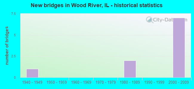
- New bridges - historical statistics
- 11940-1949
- 21980-1989
- 72000-2009


- Bridge Condition - Deck
- 40.0%Very good
- 40.0%Good
- 20.0%Fair

- Bridge Condition - Superstructure
- 60.0%Very good
- 20.0%Good
- 20.0%Fair

- Bridge Condition - Substructure
- 60.0%Very good
- 20.0%Good
- 20.0%Satisfactory

- Bridge Condition - Channel
- 50.0%Satisfactory
- 50.0%Fair

- Bridge Condition - Culverts
- 50.0%Very good
- 50.0%Good
Find on map >> Show street view
Structure Number: 600063, Location: 0.6MI N OF IL 143 (Lat: 38.865897, Lng: -90.111775), Route carried "on" structure: State highway 3, Year Built: 1947, Year Reconstructed: 1994, Status: Open, Structure Length: 8.96m (29.40ft), Average Daily Traffic: 10,500 (year 2021), Truck Traffic: 7%, Average Future Daily Traffic: 13,886 (year 2032), Design Load: H 20, Features Intersected: N&W RR
Minimum Vertical Clearance: 30+ m (98+ ft), Kilometerpoint: 265.776, Lanes on structure: 4, Base Highway Network: Yes, Owner: State Highway Agency, Approaching Roadway Width: 21.9m (71.9ft), Skew: 34 degrees, Material/Design: Steel continuous, Design/Construction: Stringer/Multi-beam, Number Of Spans In Main Unit: 4, Length of Maximum Span: 27.1m (88.9ft), Curb-To-Curb Width: 21.2m (69.6ft), Out-to-Out Width: 22.9m (75.1ft)
Condition: Deck: Fair, Superstructure: Good, Substructure: Good, Operating Rating: 72.3 metric tons, Method Used To Determine Operating Rating: Load Factor (LF) rating reported by rating factor (RF) method using MS18 loading, Inventory Rating: 43.4 metric tons, Method Used To Determine Inventory Rating: Load Factor (LF) rating reported by rating factor (RF) method using MS18 loading, Structural Evaluation: Better than present minimum criteria, Deck Geometry: Superior to present desirable criteria, Underclear: Equal to present desirable criteria, Approach Roadway Alignment: Equal to present desirable criteria, Designated Inspection Frequency: Every 24 months, Inspection Date: September 2021, Deck Structure Type: Concrete Cast-file-Place, Wearing Surface/Protective System: Deck Protection: Epoxy Coated Reinforcing
Find on map >> Show street view
Structure Number: 600212, Location: 0.3 MI E OF IL 3 (Lat: 38.859881, Lng: -90.102250), Route carried "on" structure: State highway 143, Year Built: 1981, Status: Open, Structure Length: 11.43m (37.50ft), Average Daily Traffic: 12,400 (year 2021), Truck Traffic: 6%, Average Future Daily Traffic: 14,098 (year 2032), Design Load: HS 20, Features Intersected: N&W,ICG,CONRAIL
Minimum Vertical Clearance: 30+ m (98+ ft), Kilometerpoint: 7.403, Lanes on structure: 4, Base Highway Network: Yes, Owner: State Highway Agency, Approaching Roadway Width: 17.7m (58.1ft), Skew: 30 degrees, Material/Design: Steel continuous, Design/Construction: Stringer/Multi-beam, Number Of Spans In Main Unit: 3, Length of Maximum Span: 43.7m (143.4ft), Curb or Sidewalk Widths: Left: 0.0m, Right: 1.8m (5.9ft), Curb-To-Curb Width: 18.3m (60.0ft), Out-to-Out Width: 21.1m (69.2ft)
Condition: Deck: Good, Superstructure: Fair, Substructure: Satisfactory, Operating Rating: 63.8 metric tons, Method Used To Determine Operating Rating: Load Factor (LF) rating reported by rating factor (RF) method using MS18 loading, Inventory Rating: 38.2 metric tons, Method Used To Determine Inventory Rating: Load Factor (LF) rating reported by rating factor (RF) method using MS18 loading, Structural Evaluation: Somewhat better than minimum adequacy, Deck Geometry: Somewhat better than minimum adequacy, Underclear: Superior to present desirable criteria, Approach Roadway Alignment: Equal to present desirable criteria, Designated Inspection Frequency: Every 24 months, Inspection Date: May 2020, Deck Structure Type: Concrete Cast-file-Place, Wearing Surface/Protective System: Wearing Surface: Bituminous, Membrane: Built-up, Deck Protection: Epoxy Coated Reinforcing
Find on map >> Show street view
Structure Number: 600288, Location: S OF 111 (Lat: 38.863175, Lng: -90.055417), Route carried "on" structure: Other road , Year Built: 2001, Status: Open, Structure Length: 6.75m (22.15ft), Average Daily Traffic: 250 (year 2021), Truck Traffic: 5%, Average Future Daily Traffic: 689 (year 2032), Design Load: HS 20, Features Intersected: FAP 310, Facility Carried by Structure: ROCK HILL RD FAU89
Minimum Vertical Clearance: 30+ m (98+ ft), Kilometerpoint: 1.947, Lanes on structure: 2, Lanes under structure: 4, Owner: State Highway Agency, Approaching Roadway Width: 6.6m (21.7ft), Material/Design: Steel continuous, Design/Construction: Stringer/Multi-beam, Number Of Spans In Main Unit: 2, Length of Maximum Span: 27.5m (90.2ft), Curb-To-Curb Width: 10.2m (33.5ft), Out-to-Out Width: 11.2m (36.7ft)
Condition: Deck: Very good, Superstructure: Very good, Substructure: Very good, Operating Rating: 64.5 metric tons, Method Used To Determine Operating Rating: Load Factor (LF) rating reported by rating factor (RF) method using MS18 loading, Inventory Rating: 38.6 metric tons, Method Used To Determine Inventory Rating: Load Factor (LF) rating reported by rating factor (RF) method using MS18 loading, Structural Evaluation: Equal to present desirable criteria, Deck Geometry: Better than present minimum criteria, Underclear: Better than present minimum criteria, Approach Roadway Alignment: Equal to present desirable criteria, Designated Inspection Frequency: Every 48 months, Inspection Date: November 2020, Deck Structure Type: Concrete Cast-file-Place, Wearing Surface/Protective System: Deck Protection: Epoxy Coated Reinforcing
Find on map >> Show street view
Structure Number: 600289, Location: N OF IL 143 (Lat: 38.871219, Lng: -90.060028), Route carried "on" structure: State highway 255, Year Built: 2001, Status: Open, Structure Length: 5.04m (16.54ft), Average Daily Traffic: 20,200 (year 2021), Truck Traffic: 11%, Average Future Daily Traffic: 9,222 (year 2032), Design Load: HS 20, Features Intersected: IL 111
Minimum Vertical Clearance: 30+ m (98+ ft), Kilometerpoint: 12.939, Lanes on structure: 2, Lanes under structure: 4, Base Highway Network: Yes, Owner: State Highway Agency, Approaching Roadway Width: 12.0m (39.4ft), Skew: 1 degrees, Material/Design: Steel continuous, Design/Construction: Stringer/Multi-beam, Number Of Spans In Main Unit: 2, Number Of Approach Spans: 2, Length of Maximum Span: 25.5m (83.7ft), Curb-To-Curb Width: 12.0m (39.4ft), Out-to-Out Width: 13.0m (42.7ft)
Condition: Deck: Good, Superstructure: Very good, Substructure: Very good, Operating Rating: 88.1 metric tons, Method Used To Determine Operating Rating: Load Factor (LF) rating reported by rating factor (RF) method using MS18 loading, Inventory Rating: 52.8 metric tons, Method Used To Determine Inventory Rating: Load Factor (LF) rating reported by rating factor (RF) method using MS18 loading, Structural Evaluation: Equal to present desirable criteria, Deck Geometry: Equal to present minimum criteria, Underclear: Equal to present minimum criteria, Approach Roadway Alignment: Equal to present desirable criteria, Designated Inspection Frequency: Every 48 months, Inspection Date: November 2020, Deck Structure Type: Concrete Cast-file-Place, Wearing Surface/Protective System: Deck Protection: Epoxy Coated Reinforcing
Find on map >> Show street view
Structure Number: 60029, Location: N OF IL 143 (Lat: 38.871075, Lng: -90.059914), Route carried "on" structure: State highway 255, Year Built: 2001, Status: Open, Structure Length: 5.04m (16.54ft), Average Daily Traffic: 23,000 (year 2021), Truck Traffic: 11%, Average Future Daily Traffic: 10,335 (year 2032), Design Load: HS 20, Features Intersected: IL 111
Minimum Vertical Clearance: 30+ m (98+ ft), Kilometerpoint: 12.923, Lanes on structure: 2, Lanes under structure: 4, Base Highway Network: Yes, Owner: State Highway Agency, Approaching Roadway Width: 12.0m (39.4ft), Skew: 1 degrees, Material/Design: Steel continuous, Design/Construction: Stringer/Multi-beam, Number Of Spans In Main Unit: 2, Number Of Approach Spans: 2, Length of Maximum Span: 25.5m (83.7ft), Curb-To-Curb Width: 12.0m (39.4ft), Out-to-Out Width: 13.0m (42.7ft)
Condition: Deck: Very good, Superstructure: Very good, Substructure: Very good, Operating Rating: 64.8 metric tons, Method Used To Determine Operating Rating: Load Factor (LF) rating reported by rating factor (RF) method using MS18 loading, Inventory Rating: 38.9 metric tons, Method Used To Determine Inventory Rating: Load Factor (LF) rating reported by rating factor (RF) method using MS18 loading, Structural Evaluation: Equal to present desirable criteria, Deck Geometry: Equal to present minimum criteria, Underclear: Equal to present minimum criteria, Approach Roadway Alignment: Equal to present desirable criteria, Designated Inspection Frequency: Every 48 months, Inspection Date: November 2020, Deck Structure Type: Concrete Cast-file-Place, Wearing Surface/Protective System: Deck Protection: Epoxy Coated Reinforcing
Find on map >> Show street view
Structure Number: 602038, Location: just S OF IL 111 (Lat: 38.869356, Lng: -90.058164), Route carried "on" structure: State highway 255, Year Built: 2001, Status: Open, Structure Length: 0.69m (2.26ft), Average Daily Traffic: 23,000 (year 2021), Truck Traffic: 11%, Average Future Daily Traffic: 20,670 (year 2032), Design Load: HS 20, Features Intersected: Drains to retention
Minimum Vertical Clearance: 30+ m (98+ ft), Kilometerpoint: 12.681, Lanes on structure: 4, Base Highway Network: Yes, Owner: State Highway Agency, Approaching Roadway Width: 25.2m (82.7ft), Material/Design: Concrete continuous, Design/Construction: Culvert, Number Of Spans In Main Unit: 2, Length of Maximum Span: 3.0m (9.8ft)
Condition: Channel: Fair, Culverts: Very good, Operating Rating: 89.1 metric tons, Method Used To Determine Operating Rating: Load Factor (LF) rating reported by rating factor (RF) method using MS18 loading, Inventory Rating: 89.1 metric tons, Method Used To Determine Inventory Rating: Load Factor (LF) rating reported by rating factor (RF) method using MS18 loading, Structural Evaluation: Equal to present desirable criteria, Waterway Adequacy: Equal to present desirable criteria, Approach Roadway Alignment: Equal to present desirable criteria, Designated Inspection Frequency: Every 48 months, Inspection Date: November 2020
Find on map >> Show street view
Structure Number: 60901, Location: 0.5 MI N ILL 143 (Lat: 38.872819, Lng: -90.082350), Route carried "on" structure: Other road , Year Built: 1980, Status: Open, Structure Length: 0.82m (2.69ft), Average Daily Traffic: 4,750 (year 2021), Truck Traffic: 3%, Average Future Daily Traffic: 5,406 (year 2032), Design Load: HS 20, Features Intersected: DRAINAGE CHANNEL, Facility Carried by Structure: NINTH ST
Minimum Vertical Clearance: 30+ m (98+ ft), Kilometerpoint: 1.497, Lanes on structure: 2, Owner: City or Municipal Highway Agency, Approaching Roadway Width: 12.2m (40.0ft), Material/Design: Concrete, Design/Construction: Culvert, Number Of Spans In Main Unit: 2, Length of Maximum Span: 3.7m (12.1ft), Curb-To-Curb Width: 7.3m (24.0ft), Out-to-Out Width: 7.3m (24.0ft)
Condition: Channel: Satisfactory, Culverts: Good, Operating Rating: 44.4 metric tons, Method Used To Determine Operating Rating: Assigned rating based on Load Factor Design (LFD) reported by rating factor (RF) using MS18 loading, Inventory Rating: 32.4 metric tons, Method Used To Determine Inventory Rating: Assigned rating based on Load Factor Design (LFD) reported by rating factor (RF) using MS18 loading, Structural Evaluation: Better than present minimum criteria, Deck Geometry: High priority of replacement, Waterway Adequacy: Superior to present desirable criteria, Approach Roadway Alignment: Equal to present desirable criteria, Length Of Structure Improvement: 0.82m (2.69ft), Designated Inspection Frequency: Every 48 months, Inspection Date: January 2022, Bridge Improvement Cost: $972,000, Roadway Improvement Cost: $24,000, Total Project Cost: $996,000
Find on map >> Show street view
Structure Number: 600288, Location: S OF 111 (Lat: 38.864617, Lng: -90.053867), Route carried "under" structure: State highway 255, Year Built: 2001, Structure Length: 0. m, Average Daily Traffic: 23,000 (year 2021), Truck Traffic: 11%, Features Intersected: FAP 310, Facility Carried by Structure: ROCK HILL RD FAU89
Minimum Vertical Clearance: 5.79m (19.00ft), Kilometerpoint: 12.038, Lanes on structure: 2, Lanes under structure: 4, Material/Design: Steel continuous, Design/Construction: Stringer/Multi-beam, Length of Maximum Span: 27.5m (90.2ft)
Find on map >> Show street view
Structure Number: 600289, Location: N OF IL 143 (Lat: 38.871433, Lng: -90.059822), Route carried "under" structure: State highway 111, Year Built: 2001, Structure Length: 0. m, Average Daily Traffic: 10,150 (year 2021), Truck Traffic: 4%, Features Intersected: IL 111, Facility Carried by Structure: IL 255 NB (FAP 310
Minimum Vertical Clearance: 5.36m (17.59ft), Kilometerpoint: 32.942, Lanes on structure: 2, Lanes under structure: 4, Material/Design: Steel continuous, Design/Construction: Stringer/Multi-beam, Length of Maximum Span: 25.5m (83.7ft)
Find on map >> Show street view
Structure Number: 60029, Location: N OF IL 143 (Lat: 38.871219, Lng: -90.060028), Route carried "under" structure: State highway 111, Year Built: 2001, Structure Length: 0. m, Average Daily Traffic: 10,000 (year 2021), Truck Traffic: 4%, Features Intersected: IL 111, Facility Carried by Structure: IL 255 SB (FAP 310
Minimum Vertical Clearance: 6.60m (21.65ft), Kilometerpoint: 32.910, Lanes on structure: 2, Lanes under structure: 4, Material/Design: Steel continuous, Design/Construction: Stringer/Multi-beam, Length of Maximum Span: 25.5m (83.7ft)