Bridge Statistics for Wilmette, Illinois (IL)
Condition, Traffic, Stress, Structural Evaluation, Project Costs
- National Bridge Inventory (NBI) Statistics
- 10Number of bridges
- 135ft / 40.5mTotal length
- $3,837,000Total costs
- 403,125Total average daily traffic
- 23,865Total average daily truck traffic
- National Bridge Inventory (NBI) Registered Bridges for Wilmette
- No street view available for this location
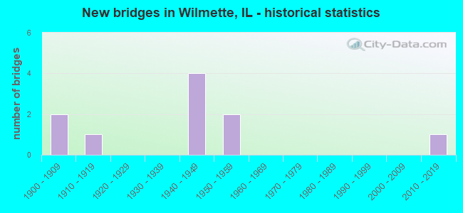
- New bridges - historical statistics
- 21900-1909
- 11910-1919
- 41940-1949
- 21950-1959
- 12010-2019

- Reconstructed bridges - Historical Statistics
- 21970-1979
- 11980-1989


- Bridge Condition - Deck
- 14.3%Very good
- 28.6%Good
- 28.6%Satisfactory
- 14.3%Fair
- 14.3%Poor

- Bridge Condition - Superstructure
- 14.3%Very good
- 71.4%Fair
- 14.3%Serious

- Bridge Condition - Substructure
- 14.3%Very good
- 14.3%Good
- 42.9%Satisfactory
- 28.6%Fair

- Bridge Condition - Channel
- 75.0%Very good
- 25.0%Good
Find on map >> Show street view
Structure Number: 160167, Location: 0.9 M S WILLOW RD (Lat: 42.084953, Lng: -87.758617), Route carried "on" structure: Other road , Year Built: 1949, Year Reconstructed: 1983, Status: Open, Structure Length: 9.06m (29.72ft), Average Daily Traffic: 10,300 (year 2021), Truck Traffic: 2%, Average Future Daily Traffic: 9,270 (year 2032), Design Load: HS 20+Mod, Features Intersected: I- 94 EDENS, Facility Carried by Structure: US 41 SB RAMP SKOK
Minimum Vertical Clearance: 30+ m (98+ ft), Kilometerpoint: 0.418, Lanes on structure: 2, Lanes under structure: 6, Base Highway Network: Yes (Inventory Route: 10094040, Subroute: 30), Owner: State Highway Agency, Approaching Roadway Width: 6.4m (21.0ft), Skew: 4 degrees, Material/Design: Steel continuous, Design/Construction: Stringer/Multi-beam, Number Of Spans In Main Unit: 4, Length of Maximum Span: 24.8m (81.4ft), Curb-To-Curb Width: 8.2m (26.9ft), Out-to-Out Width: 9.2m (30.2ft)
Condition: Deck: Poor, Superstructure: Serious, Substructure: Good, Operating Rating: 72.3 metric tons, Method Used To Determine Operating Rating: Load Factor (LF) rating reported by rating factor (RF) method using MS18 loading, Inventory Rating: 43.4 metric tons, Method Used To Determine Inventory Rating: Load Factor (LF) rating reported by rating factor (RF) method using MS18 loading, Structural Evaluation: High priority of corrective action, Deck Geometry: High priority of replacement, Underclear: High priority of corrective action, Approach Roadway Alignment: Equal to present minimum criteria, Length Of Structure Improvement: 8.96m (29.40ft), Designated Inspection Frequency: Every 12 months, Inspection Date: June 2021, Bridge Improvement Cost: $512,000, Roadway Improvement Cost: $51,000, Total Project Cost: $845,000, Deck Structure Type: Concrete Cast-file-Place, Wearing Surface/Protective System: Deck Protection: Epoxy Coated Reinforcing
Find on map >> Show street view
Structure Number: 160545, Location: 2.7 M N IL 58 (Lat: 42.079517, Lng: -87.759042), Route carried "on" structure: Other road , Year Built: 1950, Year Reconstructed: 1987, Status: Open, Structure Length: 6.91m (22.67ft), Average Daily Traffic: 21,700 (year 2018), Truck Traffic: 3%, Average Future Daily Traffic: 23,175 (year 2032), Design Load: HS 20, Features Intersected: I- 94 EDENS, Facility Carried by Structure: LAKE AVE
Minimum Vertical Clearance: 30+ m (98+ ft), Kilometerpoint: 25.829, Lanes on structure: 5, Lanes under structure: 8, Base Highway Network: Yes, Owner: State Highway Agency, Approaching Roadway Width: 19.2m (63.0ft), Skew: 30 degrees, Material/Design: Steel continuous, Design/Construction: Stringer/Multi-beam, Number Of Spans In Main Unit: 4, Length of Maximum Span: 19.2m (63.0ft), Curb or Sidewalk Widths: Left: 1.5m (4.9ft), Right: 1.5m (4.9ft), Curb-To-Curb Width: 21.0m (68.9ft), Out-to-Out Width: 24.4m (80.1ft)
Condition: Deck: Fair, Superstructure: Fair, Substructure: Fair, Operating Rating: 49.6 metric tons, Method Used To Determine Operating Rating: Allowable Stress (AS) rating reported by rating factor (RF) method using MS18 loading, Inventory Rating: 33.4 metric tons, Method Used To Determine Inventory Rating: Allowable Stress (AS) rating reported by rating factor (RF) method using MS18 loading, Structural Evaluation: Somewhat better than minimum adequacy, Deck Geometry: Somewhat better than minimum adequacy, Underclear: High priority of corrective action, Approach Roadway Alignment: Equal to present desirable criteria, Designated Inspection Frequency: Every 24 months, Inspection Date: October 2020, Deck Structure Type: Concrete Cast-file-Place, Wearing Surface/Protective System: Deck Protection: Epoxy Coated Reinforcing
Find on map >> Show street view
Structure Number: 16062, Location: 2.5 M N ILL 58 P12 (Lat: 42.075703, Lng: -87.685414), Route carried "on" structure: Other road , Year Built: 1911, Status: Open, Structure Length: 6.40m (21.00ft), Average Daily Traffic: 10,500 (year 2018), Truck Traffic: 3%, Average Future Daily Traffic: 9,682 (year 2032), Design Load: H 15, Features Intersected: N SHORE CHANNEL, Facility Carried by Structure: SHERIDAN RD
Minimum Vertical Clearance: 30+ m (98+ ft), Kilometerpoint: 11.217, Lanes on structure: 4, Base Highway Network: Yes, Owner: Local Agency, Approaching Roadway Width: 12.8m (42.0ft), Material/Design: Steel, Design/Construction: Stringer/Multi-beam, Number Of Spans In Main Unit: 5, Length of Maximum Span: 23.5m (77.1ft), Curb or Sidewalk Widths: Left: 2.4m (7.9ft), Right: 2.4m (7.9ft), Curb-To-Curb Width: 14.0m (45.9ft), Out-to-Out Width: 19.3m (63.3ft)
Condition: Deck: Good, Superstructure: Fair, Substructure: Satisfactory, Channel: Very good, Operating Rating: 33.7 metric tons, Method Used To Determine Operating Rating: Allowable Stress (AS) rating reported by rating factor (RF) method using MS18 loading, Inventory Rating: 17.2 metric tons, Method Used To Determine Inventory Rating: Allowable Stress (AS) rating reported by rating factor (RF) method using MS18 loading, Structural Evaluation: Meets minimum limits, Deck Geometry: High priority of replacement, Waterway Adequacy: Superior to present desirable criteria, Approach Roadway Alignment: Equal to present desirable criteria, Length Of Structure Improvement: 7.68m (25.20ft), Designated Inspection Frequency: Every 24 months, Inspection Date: December 2021, Bridge Improvement Cost: $1,757,000, Roadway Improvement Cost: $176,000, Total Project Cost: $2,636,000, Deck Structure Type: Concrete Cast-file-Place, Wearing Surface/Protective System: Wearing Surface: Bituminous, Deck Protection: Epoxy Coated Reinforcing
Find on map >> Show street view
Structure Number: 160821, Location: 2 M N IL 58 (Lat: 42.068628, Lng: -87.756614), Route carried "on" structure: Other road , Year Built: 1949, Year Reconstructed: 1984, Status: Open, Structure Length: 7.06m (23.16ft), Average Daily Traffic: 2,425 (year 2021), Truck Traffic: 3%, Average Future Daily Traffic: 10,403 (year 2032), Design Load: HS 20, Features Intersected: I- 94 EDENS, Facility Carried by Structure: GLENVIEW RD
Minimum Vertical Clearance: 30+ m (98+ ft), Kilometerpoint: 9.237, Lanes on structure: 4, Lanes under structure: 6, Base Highway Network: Yes, Owner: State Highway Agency, Approaching Roadway Width: 15.8m (51.8ft), Material/Design: Steel continuous, Design/Construction: Stringer/Multi-beam, Number Of Spans In Main Unit: 4, Length of Maximum Span: 19.5m (64.0ft), Curb or Sidewalk Widths: Left: 1.4m (4.6ft), Right: 1.4m (4.6ft), Curb-To-Curb Width: 15.8m (51.8ft), Out-to-Out Width: 19.5m (64.0ft)
Condition: Deck: Satisfactory, Superstructure: Fair, Substructure: Fair, Operating Rating: 65.1 metric tons, Method Used To Determine Operating Rating: Load Factor (LF) rating reported by rating factor (RF) method using MS18 loading, Inventory Rating: 34.0 metric tons, Method Used To Determine Inventory Rating: Load Factor (LF) rating reported by rating factor (RF) method using MS18 loading, Structural Evaluation: Somewhat better than minimum adequacy, Deck Geometry: Meets minimum limits, Underclear: High priority of corrective action, Approach Roadway Alignment: Equal to present desirable criteria, Length Of Structure Improvement: 7.10m (23.29ft), Designated Inspection Frequency: Every 24 months, Inspection Date: October 2020, Bridge Improvement Cost: $297,000, Roadway Improvement Cost: $15,000, Total Project Cost: $356,000, Deck Structure Type: Concrete Cast-file-Place, Wearing Surface/Protective System: Wearing Surface: Other
Find on map >> Show street view
Structure Number: 163056, Location: 0.5 Mi S of Winnetka (Lat: 42.086550, Lng: -87.766300), Route carried "on" structure: Other road , Year Built: 2017, Status: Open, Structure Length: 2.29m (7.51ft), Average Daily Traffic: 4,100 (year 2018), Truck Traffic: 6%, Average Future Daily Traffic: 3,399 (year 2032), Design Load: HS 25 or greater, Features Intersected: Skokie River, Facility Carried by Structure: Happ Road
Minimum Vertical Clearance: 30+ m (98+ ft), Kilometerpoint: 0.837, Lanes on structure: 2, Owner: County Highway Agency, Approaching Roadway Width: 8.5m (27.9ft), Material/Design: Concrete continuous, Design/Construction: Slab, Number Of Spans In Main Unit: 3, Number Of Approach Spans: 2, Length of Maximum Span: 8.2m (26.9ft), Curb or Sidewalk Widths: Left: 3.0m (9.8ft), Right: 0.0m, Curb-To-Curb Width: 11.6m (38.1ft), Out-to-Out Width: 12.9m (42.3ft)
Condition: Deck: Very good, Superstructure: Very good, Substructure: Very good, Channel: Very good, Operating Rating: 72.9 metric tons, Method Used To Determine Operating Rating: Load and Resistance Factor Rating (LRFR) rating reported by rating factor(RF) method using HL-93 loadings, Inventory Rating: 56.4 metric tons, Method Used To Determine Inventory Rating: Load and Resistance Factor Rating (LRFR) rating reported by rating factor(RF) method using HL-93 loadings, Structural Evaluation: Equal to present desirable criteria, Deck Geometry: Somewhat better than minimum adequacy, Waterway Adequacy: Better than present minimum criteria, Approach Roadway Alignment: Equal to present desirable criteria, Designated Inspection Frequency: Every 48 months, Inspection Date: November 2019, Deck Structure Type: Concrete Cast-file-Place, Wearing Surface/Protective System: Deck Protection: Epoxy Coated Reinforcing
Find on map >> Show street view
Structure Number: 169958, Location: WILMETTE (Lat: 42.073725, Lng: -87.687797), Route carried "on" structure: City street , Year Built: 1909, Status: Open, Structure Length: 4.39m (14.40ft), Average Daily Traffic: 1,400 (year 2018), Truck Traffic: 5%, Average Future Daily Traffic: 3,039 (year 2032), Features Intersected: N SHORE CHANNEL, Facility Carried by Structure: LINDEN AVE
Minimum Vertical Clearance: 30+ m (98+ ft), Kilometerpoint: 1.979, Lanes on structure: 2, Owner: Local Agency, Approaching Roadway Width: 7.3m (24.0ft), Material/Design: Steel, Design/Construction: Girder and Floorbeam System, Number Of Spans In Main Unit: 3, Length of Maximum Span: 21.6m (70.9ft), Curb or Sidewalk Widths: Left: 1.9m (6.2ft), Right: 1.9m (6.2ft), Curb-To-Curb Width: 7.3m (24.0ft), Out-to-Out Width: 11.8m (38.7ft)
Condition: Deck: Good, Superstructure: Fair, Substructure: Satisfactory, Channel: Good, Operating Rating: 42.1 metric tons, Method Used To Determine Operating Rating: Allowable Stress (AS) rating reported by rating factor (RF) method using MS18 loading, Inventory Rating: 29.5 metric tons, Method Used To Determine Inventory Rating: Allowable Stress (AS) rating reported by rating factor (RF) method using MS18 loading, Structural Evaluation: Somewhat better than minimum adequacy, Deck Geometry: Meets minimum limits, Waterway Adequacy: Superior to present desirable criteria, Approach Roadway Alignment: Equal to present desirable criteria, Designated Inspection Frequency: Every 24 months, Critical Feature Inspection Frequency: Every 24 months, Inspection Date: December 2021, Critical Feature Inspection Date: December 2021, Deck Structure Type: Open Grating, Wearing Surface/Protective System: Wearing Surface: Other
Find on map >> Show street view
Structure Number: 169959, Location: WILMETTE (Lat: 42.071186, Lng: -87.686672), Route carried "on" structure: City street , Year Built: 1909, Status: Open, Structure Length: 4.39m (14.40ft), Average Daily Traffic: 200 (year 2018), Truck Traffic: 14%, Average Future Daily Traffic: 412 (year 2032), Features Intersected: N SHORE CHANNEL, Facility Carried by Structure: MAPLE AVE
Minimum Vertical Clearance: 30+ m (98+ ft), Kilometerpoint: 0.885, Lanes on structure: 2, Owner: Local Agency, Approaching Roadway Width: 7.3m (24.0ft), Material/Design: Steel, Design/Construction: Girder and Floorbeam System, Number Of Spans In Main Unit: 3, Length of Maximum Span: 21.6m (70.9ft), Curb or Sidewalk Widths: Left: 1.9m (6.2ft), Right: 1.9m (6.2ft), Curb-To-Curb Width: 7.3m (24.0ft), Out-to-Out Width: 11.8m (38.7ft)
Condition: Deck: Satisfactory, Superstructure: Fair, Substructure: Satisfactory, Channel: Very good, Operating Rating: 45.0 metric tons, Method Used To Determine Operating Rating: Allowable Stress (AS) rating reported by rating factor (RF) method using MS18 loading, Inventory Rating: 30.1 metric tons, Method Used To Determine Inventory Rating: Allowable Stress (AS) rating reported by rating factor (RF) method using MS18 loading, Structural Evaluation: Somewhat better than minimum adequacy, Deck Geometry: Somewhat better than minimum adequacy, Waterway Adequacy: Superior to present desirable criteria, Approach Roadway Alignment: Equal to present desirable criteria, Designated Inspection Frequency: Every 24 months, Critical Feature Inspection Frequency: Every 24 months, Inspection Date: December 2021, Critical Feature Inspection Date: December 2021, Deck Structure Type: Open Grating, Wearing Surface/Protective System: Wearing Surface: Other
Find on map >> Show street view
Structure Number: 160167, Location: 0.9 M S WILLOW RD (Lat: 42.084953, Lng: -87.758617), Route carried "under" structure: Interstate 94, Year Built: 1949, Structure Length: 0. m, Average Daily Traffic: 118,100 (year 2021), Truck Traffic: 6%, Features Intersected: I- 94 EDENS, Facility Carried by Structure: US 41 SB RAMP SKOK
Minimum Vertical Clearance: 4.65m (15.26ft), Kilometerpoint: 55.054, Lanes on structure: 2, Lanes under structure: 6, Material/Design: Steel continuous, Design/Construction: Stringer/Multi-beam, Length of Maximum Span: 24.8m (81.4ft)
Find on map >> Show street view
Structure Number: 160545, Location: 2.7 M N IL 58 (Lat: 42.079514, Lng: -87.758703), Route carried "under" structure: Interstate 94, Year Built: 1950, Structure Length: 0. m, Average Daily Traffic: 112,700 (year 2021), Truck Traffic: 7%, Features Intersected: I- 94 EDENS, Facility Carried by Structure: LAKE AVE
Minimum Vertical Clearance: 4.22m (13.85ft), Kilometerpoint: 55.650, Lanes on structure: 5, Lanes under structure: 8, Material/Design: Steel continuous, Design/Construction: Stringer/Multi-beam, Length of Maximum Span: 19.2m (63.0ft)
Find on map >> Show street view
Structure Number: 160821, Location: 2 M N IL 58 (Lat: 42.068628, Lng: -87.756614), Route carried "under" structure: Interstate 94, Year Built: 1949, Structure Length: 0. m, Average Daily Traffic: 121,700 (year 2021), Truck Traffic: 6%, Features Intersected: I- 94 EDENS, Facility Carried by Structure: GLENVIEW RD
Minimum Vertical Clearance: 4.57m (14.99ft), Kilometerpoint: 56.889, Lanes on structure: 4, Lanes under structure: 6, Material/Design: Steel continuous, Design/Construction: Stringer/Multi-beam, Length of Maximum Span: 19.5m (64.0ft)