Bridge Statistics for Willow Grove, Pennsylvania (PA)
Condition, Traffic, Stress, Structural Evaluation, Project Costs
- National Bridge Inventory (NBI) Statistics
- 30Number of bridges
- 131ft / 39.6mTotal length
- $4,433,000Total costs
- 849,800Total average daily traffic
- 81,902Total average daily truck traffic
- National Bridge Inventory (NBI) Registered Bridges for Willow Grove
- No street view available for this location
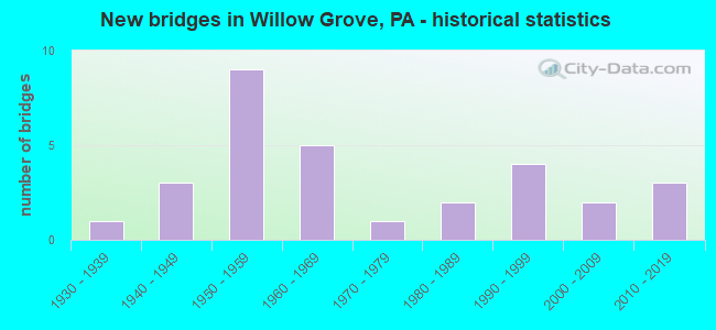
- New bridges - historical statistics
- 11930-1939
- 31940-1949
- 91950-1959
- 51960-1969
- 11970-1979
- 21980-1989
- 41990-1999
- 22000-2009
- 32010-2019

- Reconstructed bridges - Historical Statistics
- 21970-1979
- 11980-1989
- 01990-1999
- 02000-2009
- 22010-2019


- Bridge Condition - Deck
- 13.3%Very good
- 26.7%Good
- 46.7%Satisfactory
- 13.3%Fair

- Bridge Condition - Superstructure
- 14.3%Very good
- 35.7%Good
- 28.6%Satisfactory
- 21.4%Fair

- Bridge Condition - Substructure
- 35.7%Good
- 35.7%Satisfactory
- 28.6%Fair

- Bridge Condition - Channel
- 6.7%Excellent
- 6.7%Good
- 13.3%Satisfactory
- 53.3%Fair
- 20.0%Poor

- Bridge Condition - Culverts
- 50.0%Good
- 37.5%Satisfactory
- 12.5%Poor
Find on map >> Show street view
Structure Number: 27176, Location: SE OF T-PIKE 31K1/3258H6 (Lat: 40.153989, Lng: -75.138264), Route carried "on" structure: State highway 63, Year Built: 1966, Status: Open, Structure Length: 2.50m (8.20ft), Average Daily Traffic: 25,100 (year 2021), Truck Traffic: 2%, Average Future Daily Traffic: 30,770 (year 2032), Design Load: H 20, Features Intersected: NORFOLK SOUTHERN, Facility Carried by Structure: WELSH ROAD
Minimum Vertical Clearance: 30+ m (98+ ft), Kilometerpoint: 38.027, Lanes on structure: 4, Base Highway Network: Yes, Owner: State Highway Agency, Approaching Roadway Width: 15.2m (49.9ft), Skew: 22 degrees, Material/Design: Prestressed concrete, Design/Construction: Box Beam or Girders - Multiple, Number Of Spans In Main Unit: 1, Length of Maximum Span: 24.4m (80.1ft), Curb or Sidewalk Widths: Left: 1.5m (4.9ft), Right: 1.5m (4.9ft), Curb-To-Curb Width: 15.2m (49.9ft), Out-to-Out Width: 19.2m (63.0ft)
Condition: Deck: Very good, Superstructure: Satisfactory, Substructure: Satisfactory, Inventory Rating: 32.7 metric tons, Method Used To Determine Inventory Rating: Load Factor (LF), Structural Evaluation: Equal to present minimum criteria, Deck Geometry: High priority of corrective action, Underclear: High priority of corrective action, Approach Roadway Alignment: Equal to present desirable criteria, Length Of Structure Improvement: 3.20m (10.50ft), Designated Inspection Frequency: Every 24 months, Inspection Date: January 2021, Bridge Improvement Cost: $39,000, Roadway Improvement Cost: $114,000, Total Project Cost: $523,000, Deck Structure Type: Concrete Precast Panels, Wearing Surface/Protective System: Wearing Surface: Monolithic Concrete
Find on map >> Show street view
Structure Number: 27352, Location: N.PENA TRNPK 25D13/3259C4 (Lat: 40.163144, Lng: -75.111147), Route carried "on" structure: State highway 263, Year Built: 1968, Status: Open, Structure Length: 0.85m (2.79ft), Average Daily Traffic: 27,740 (year 2022), Truck Traffic: 8%, Average Future Daily Traffic: 33,422 (year 2032), Design Load: HS 20, Features Intersected: BRANCH PENNYPACK CREEK, Facility Carried by Structure: OLD YORK ROAD
Minimum Vertical Clearance: 30+ m (98+ ft), Kilometerpoint: 1.749, Lanes on structure: 5, Base Highway Network: Yes, Owner: State Highway Agency, Approaching Roadway Width: 15.2m (49.9ft), Material/Design: Prestressed concrete, Design/Construction: Box Beam or Girders - Multiple, Number Of Spans In Main Unit: 1, Length of Maximum Span: 8.2m (26.9ft), Curb or Sidewalk Widths: Left: 1.5m (4.9ft), Right: 1.5m (4.9ft), Curb-To-Curb Width: 15.2m (49.9ft), Out-to-Out Width: 19.2m (63.0ft)
Condition: Deck: Satisfactory, Superstructure: Fair, Substructure: Satisfactory, Channel: Poor, Operating Rating: 80.7 metric tons, Method Used To Determine Operating Rating: Load Factor (LF), Inventory Rating: 45.4 metric tons, Method Used To Determine Inventory Rating: Load Factor (LF), Structural Evaluation: Somewhat better than minimum adequacy, Deck Geometry: High priority of replacement, Waterway Adequacy: Somewhat better than minimum adequacy, Approach Roadway Alignment: Equal to present desirable criteria, Length Of Structure Improvement: 1.50m (4.92ft), Designated Inspection Frequency: Every 24 months, Inspection Date: August 2020, Bridge Improvement Cost: $14,000, Roadway Improvement Cost: $40,000, Total Project Cost: $183,000, Deck Structure Type: Concrete Cast-file-Place, Wearing Surface/Protective System: Wearing Surface: Monolithic Concrete
Find on map >> Show street view
Structure Number: 27503, Location: T-P INTER. 25B13/3259A5 (Lat: 40.158656, Lng: -75.122653), Route carried "on" structure: State highway 611, Year Built: 1959, Status: Open, Structure Length: 0.67m (2.20ft), Average Daily Traffic: 31,353 (year 2022), Truck Traffic: 5%, Average Future Daily Traffic: 33,038 (year 2032), Design Load: HS 20, Features Intersected: BRANCH PENNYPACK CREEK, Facility Carried by Structure: EASTON ROAD
Minimum Vertical Clearance: 30+ m (98+ ft), Kilometerpoint: 11.566, Lanes on structure: 4, Base Highway Network: Yes, Owner: State Highway Agency, Approaching Roadway Width: 15.2m (49.9ft), Skew: 20 degrees, Material/Design: Concrete, Design/Construction: Tee Beam, Number Of Spans In Main Unit: 1, Length of Maximum Span: 6.4m (21.0ft), Curb or Sidewalk Widths: Left: 1.4m (4.6ft), Right: 1.4m (4.6ft), Curb-To-Curb Width: 15.2m (49.9ft), Out-to-Out Width: 18.9m (62.0ft)
Condition: Deck: Fair, Superstructure: Fair, Substructure: Fair, Channel: Fair, Operating Rating: 70.8 metric tons, Method Used To Determine Operating Rating: Load Factor (LF), Inventory Rating: 42.6 metric tons, Method Used To Determine Inventory Rating: Load Factor (LF), Structural Evaluation: Somewhat better than minimum adequacy, Deck Geometry: High priority of corrective action, Waterway Adequacy: Equal to present minimum criteria, Approach Roadway Alignment: Equal to present desirable criteria, Length Of Structure Improvement: 1.30m (4.27ft), Designated Inspection Frequency: Every 24 months, Inspection Date: December 2020, Deck Structure Type: Concrete Cast-file-Place, Wearing Surface/Protective System: Wearing Surface: Monolithic Concrete
Find on map >> Show street view
Structure Number: 27505, Location: S.TURNPIKE INTERC. 25B13 (Lat: 40.161850, Lng: -75.123686), Route carried "on" structure: State highway 611, Year Built: 1959, Year Reconstructed: 1983, Status: Open, Structure Length: 0.91m (2.99ft), Average Daily Traffic: 31,353 (year 2022), Truck Traffic: 5%, Average Future Daily Traffic: 33,038 (year 2032), Design Load: HS 20, Features Intersected: BRANCH PENNYPACK CREEK, Facility Carried by Structure: EASTON ROAD
Minimum Vertical Clearance: 30+ m (98+ ft), Kilometerpoint: 11.566, Lanes on structure: 5, Base Highway Network: Yes, Owner: State Highway Agency, Approaching Roadway Width: 21.3m (69.9ft), Skew: 30 degrees, Material/Design: Concrete, Design/Construction: Tee Beam, Number Of Spans In Main Unit: 1, Length of Maximum Span: 8.8m (28.9ft), Curb or Sidewalk Widths: Left: 1.1m (3.6ft), Right: 0.7m (2.3ft), Curb-To-Curb Width: 17.7m (58.1ft), Out-to-Out Width: 21.0m (68.9ft)
Condition: Deck: Satisfactory, Superstructure: Fair, Substructure: Satisfactory, Channel: Fair, Operating Rating: 65.3 metric tons, Method Used To Determine Operating Rating: Load Factor (LF), Inventory Rating: 39.0 metric tons, Method Used To Determine Inventory Rating: Load Factor (LF), Structural Evaluation: Somewhat better than minimum adequacy, Deck Geometry: High priority of replacement, Waterway Adequacy: Somewhat better than minimum adequacy, Approach Roadway Alignment: Equal to present desirable criteria, Length Of Structure Improvement: 1.60m (5.25ft), Designated Inspection Frequency: Every 24 months, Inspection Date: November 2020, Bridge Improvement Cost: $14,000, Roadway Improvement Cost: $40,000, Total Project Cost: $184,000, Deck Structure Type: Concrete Cast-file-Place, Wearing Surface/Protective System: Wearing Surface: Integral Concrete
Find on map >> Show street view
Structure Number: 27648, Location: WILLOW GROVE 32C05 (Lat: 40.136081, Lng: -75.117478), Route carried "on" structure: State highway , Year Built: 1991, Status: Open, Structure Length: 2.04m (6.69ft), Average Daily Traffic: 10,067 (year 2022), Truck Traffic: 2%, Average Future Daily Traffic: 14,433 (year 2032), Design Load: HS 25 or greater, Features Intersected: SEPTA, Facility Carried by Structure: OLD WELSH ROAD
Minimum Vertical Clearance: 30+ m (98+ ft), Kilometerpoint: 0.605, Lanes on structure: 2, Owner: State Highway Agency, Approaching Roadway Width: 9.1m (29.9ft), Skew: 1 degrees, Material/Design: Prestressed concrete, Design/Construction: Box Beam or Girders - Single/Spread, Number Of Spans In Main Unit: 1, Length of Maximum Span: 19.8m (65.0ft), Curb or Sidewalk Widths: Left: 1.5m (4.9ft), Right: 1.5m (4.9ft), Curb-To-Curb Width: 9.1m (29.9ft), Out-to-Out Width: 12.8m (42.0ft)
Condition: Deck: Good, Superstructure: Good, Substructure: Good, Inventory Rating: 54.4 metric tons, Method Used To Determine Inventory Rating: Load Factor (LF), Structural Evaluation: Better than present minimum criteria, Deck Geometry: High priority of corrective action, Underclear: High priority of corrective action, Approach Roadway Alignment: Better than present minimum criteria, Length Of Structure Improvement: 2.70m (8.86ft), Designated Inspection Frequency: Every 24 months, Inspection Date: May 2021, Deck Structure Type: Concrete Cast-file-Place, Wearing Surface/Protective System: Wearing Surface: Monolithic Concrete, Deck Protection: Epoxy Coated Reinforcing
Find on map >> Show street view
Structure Number: 27657, Location: HEATON BORO. 32E01/3259C5 (Lat: 40.157089, Lng: -75.107247), Route carried "on" structure: State highway , Year Built: 1966, Year Reconstructed: 2017, Status: Open, Structure Length: 0.79m (2.59ft), Average Daily Traffic: 15,875 (year 2022), Truck Traffic: 5%, Average Future Daily Traffic: 20,259 (year 2032), Design Load: HS 20, Features Intersected: BR.PENNYPACK CREEK, Facility Carried by Structure: TERWOOD ROAD
Minimum Vertical Clearance: 30+ m (98+ ft), Kilometerpoint: 4.796, Lanes on structure: 2, Owner: State Highway Agency, Approaching Roadway Width: 12.2m (40.0ft), Skew: 3 degrees, Material/Design: Concrete, Design/Construction: Slab, Number Of Spans In Main Unit: 1, Length of Maximum Span: 7.3m (24.0ft), Curb or Sidewalk Widths: Left: 1.5m (4.9ft), Right: 1.5m (4.9ft), Curb-To-Curb Width: 12.2m (40.0ft), Out-to-Out Width: 16.0m (52.5ft)
Condition: Deck: Satisfactory, Superstructure: Satisfactory, Substructure: Satisfactory, Channel: Fair, Operating Rating: 73.5 metric tons, Method Used To Determine Operating Rating: Load Factor (LF), Inventory Rating: 44.5 metric tons, Method Used To Determine Inventory Rating: Load Factor (LF), Structural Evaluation: Equal to present minimum criteria, Deck Geometry: Somewhat better than minimum adequacy, Waterway Adequacy: Equal to present minimum criteria, Approach Roadway Alignment: Equal to present desirable criteria, Length Of Structure Improvement: 1.40m (4.59ft), Designated Inspection Frequency: Every 24 months, Inspection Date: June 2020, Deck Structure Type: Concrete Cast-file-Place, Wearing Surface/Protective System: Wearing Surface: Latex Concrete
Find on map >> Show street view
Structure Number: 27659, Location: 1MI.S.WELSH RD 32C6 (Lat: 40.127519, Lng: -75.116958), Route carried "on" structure: State highway , Year Built: 1947, Year Reconstructed: 2017, Status: Open, Structure Length: 3.51m (11.52ft), Average Daily Traffic: 6,111 (year 2020), Truck Traffic: 6%, Average Future Daily Traffic: 8,581 (year 2032), Design Load: HL 93, Features Intersected: OLD YORK RD 3259B10, Facility Carried by Structure: EDGE HILL RD
Minimum Vertical Clearance: 30+ m (98+ ft), Kilometerpoint: 8.005, Lanes on structure: 2, Lanes under structure: 4, Owner: State Highway Agency, Approaching Roadway Width: 10.1m (33.1ft), Skew: 4 degrees, Material/Design: Steel, Design/Construction: Stringer/Multi-beam, Number Of Spans In Main Unit: 1, Length of Maximum Span: 34.4m (112.9ft), Curb or Sidewalk Widths: Left: 1.5m (4.9ft), Right: 1.5m (4.9ft), Curb-To-Curb Width: 7.3m (24.0ft), Out-to-Out Width: 11.0m (36.1ft)
Condition: Deck: Very good, Superstructure: Very good, Substructure: Good, Operating Rating: 57.7 metric tons, Method Used To Determine Operating Rating: Assigned ratings based on Load and Resistance Factor Design (LRFD) reported by rating factor (RF) using HL93 loadings, Inventory Rating: 44.4 metric tons, Method Used To Determine Inventory Rating: Assigned ratings based on Load and Resistance Factor Design (LRFD) reported by rating factor (RF) using HL93 loadings, Structural Evaluation: Better than present minimum criteria, Deck Geometry: High priority of replacement, Underclear: High priority of corrective action, Approach Roadway Alignment: Equal to present desirable criteria, Length Of Structure Improvement: 4.40m (14.44ft), Designated Inspection Frequency: Every 24 months, Inspection Date: November 2019, Bridge Improvement Cost: $68,000, Roadway Improvement Cost: $199,000, Total Project Cost: $912,000, Deck Structure Type: Concrete Cast-file-Place, Wearing Surface/Protective System: Wearing Surface: Monolithic Concrete, Deck Protection: Epoxy Coated Reinforcing
Find on map >> Show street view
Structure Number: 27663, Location: HEATON BOROUGH 25C13 (Lat: 40.158931, Lng: -75.114975), Route carried "on" structure: State highway , Year Built: 1967, Status: Open, Structure Length: 0.73m (2.40ft), Average Daily Traffic: 14,976 (year 2022), Truck Traffic: 5%, Average Future Daily Traffic: 21,447 (year 2032), Design Load: HS 20, Features Intersected: BRANCH PENNYPACK CREEK, Facility Carried by Structure: FITZWATERTOWN ROAD
Minimum Vertical Clearance: 30+ m (98+ ft), Kilometerpoint: 5.185, Lanes on structure: 2, Owner: State Highway Agency, Approaching Roadway Width: 12.2m (40.0ft), Material/Design: Prestressed concrete, Design/Construction: Slab, Number Of Spans In Main Unit: 1, Length of Maximum Span: 7.0m (23.0ft), Curb or Sidewalk Widths: Left: 1.5m (4.9ft), Right: 1.5m (4.9ft), Curb-To-Curb Width: 12.2m (40.0ft), Out-to-Out Width: 16.0m (52.5ft)
Condition: Deck: Satisfactory, Superstructure: Good, Substructure: Fair, Channel: Poor, Operating Rating: 92.5 metric tons, Method Used To Determine Operating Rating: Load Factor (LF), Inventory Rating: 55.3 metric tons, Method Used To Determine Inventory Rating: Load Factor (LF), Structural Evaluation: Somewhat better than minimum adequacy, Deck Geometry: Somewhat better than minimum adequacy, Waterway Adequacy: Equal to present minimum criteria, Approach Roadway Alignment: Equal to present desirable criteria, Length Of Structure Improvement: 1.40m (4.59ft), Designated Inspection Frequency: Every 24 months, Inspection Date: April 2020, Deck Structure Type: Concrete Precast Panels, Wearing Surface/Protective System: Wearing Surface: Bituminous
Find on map >> Show street view
Structure Number: 27668, Location: UPPER MORELAND 32F01 (Lat: 40.157958, Lng: -75.099325), Route carried "on" structure: State highway , Year Built: 1996, Status: Open, Structure Length: 3.20m (10.50ft), Average Daily Traffic: 14,333 (year 2022), Truck Traffic: 5%, Average Future Daily Traffic: 20,237 (year 2032), Design Load: HS 25 or greater, Features Intersected: PENNYPACK CREEK, Facility Carried by Structure: DAVISVILLE ROAD
Minimum Vertical Clearance: 30+ m (98+ ft), Kilometerpoint: 2.087, Lanes on structure: 2, Owner: State Highway Agency, Approaching Roadway Width: 7.9m (25.9ft), Skew: 1 degrees, Material/Design: Prestressed concrete, Design/Construction: Box Beam or Girders - Single/Spread, Number Of Spans In Main Unit: 1, Length of Maximum Span: 30.8m (101.0ft), Curb or Sidewalk Widths: Left: 0.2m (0.7ft), Right: 0.2m (0.7ft), Curb-To-Curb Width: 12.2m (40.0ft), Out-to-Out Width: 13.3m (43.6ft)
Condition: Deck: Good, Superstructure: Good, Substructure: Good, Channel: Fair, Inventory Rating: 48.1 metric tons, Method Used To Determine Inventory Rating: Load Factor (LF), Structural Evaluation: Better than present minimum criteria, Deck Geometry: Somewhat better than minimum adequacy, Waterway Adequacy: Equal to present minimum criteria, Approach Roadway Alignment: Equal to present desirable criteria, Length Of Structure Improvement: 7.80m (25.59ft), Designated Inspection Frequency: Every 24 months, Inspection Date: April 2020, Deck Structure Type: Concrete Cast-file-Place, Wearing Surface/Protective System: Wearing Surface: Monolithic Concrete, Deck Protection: Epoxy Coated Reinforcing
Find on map >> Show street view
Structure Number: 27669, Location: UPPER MORELAND 32F01 (Lat: 40.158333, Lng: -75.100000), Route carried "on" structure: State highway , Year Built: 1996, Status: Open, Structure Length: 0.64m (2.10ft), Average Daily Traffic: 14,333 (year 2022), Truck Traffic: 5%, Average Future Daily Traffic: 20,237 (year 2032), Design Load: HS 25 or greater, Features Intersected: BR.PENNYPACK CR/ 3259-E5, Facility Carried by Structure: DAVISVILLE ROAD
Minimum Vertical Clearance: 30+ m (98+ ft), Kilometerpoint: 2.087, Lanes on structure: 2, Owner: State Highway Agency, Approaching Roadway Width: 12.2m (40.0ft), Skew: 2 degrees, Material/Design: Concrete, Design/Construction: Culvert, Number Of Spans In Main Unit: 1, Length of Maximum Span: 6.4m (21.0ft)
Condition: Channel: Fair, Culverts: Good, Inventory Rating: 81.6 metric tons, Method Used To Determine Inventory Rating: Load Factor (LF), Structural Evaluation: Better than present minimum criteria, Waterway Adequacy: Equal to present desirable criteria, Approach Roadway Alignment: Equal to present desirable criteria, Length Of Structure Improvement: 1.20m (3.94ft), Designated Inspection Frequency: Every 24 months, Inspection Date: September 2021
Find on map >> Show street view
Structure Number: 2801, Location: 1.7MI NE OR SR611 3371-E3 (Lat: 40.110997, Lng: -75.098397), Route carried "on" structure: State highway , Year Built: 1963, Status: Open, Structure Length: 1.10m (3.61ft), Average Daily Traffic: 8,000 (year 2010), Average Future Daily Traffic: 10,000 (year 2030), Design Load: H 20, Features Intersected: MEADOWBROOK CREEK, Facility Carried by Structure: VALLEY ROAD
Minimum Vertical Clearance: 30+ m (98+ ft), Kilometerpoint: 0.000, Lanes on structure: 3, Owner: Town or Township Highway Agency, Approaching Roadway Width: 12.5m (41.0ft), Skew: 3 degrees, Material/Design: Concrete, Design/Construction: Tee Beam, Number Of Spans In Main Unit: 1, Length of Maximum Span: 10.4m (34.1ft), Curb or Sidewalk Widths: Left: 1.5m (4.9ft), Right: 1.5m (4.9ft), Curb-To-Curb Width: 12.3m (40.4ft), Out-to-Out Width: 16.2m (53.1ft)
Condition: Deck: Good, Superstructure: Good, Substructure: Good, Channel: Poor, Operating Rating: 86.2 metric tons, Method Used To Determine Operating Rating: Load Factor (LF), Inventory Rating: 51.7 metric tons, Method Used To Determine Inventory Rating: Load Factor (LF), Structural Evaluation: Better than present minimum criteria, Deck Geometry: Meets minimum limits, Waterway Adequacy: Better than present minimum criteria, Approach Roadway Alignment: Equal to present desirable criteria, Length Of Structure Improvement: 1.40m (4.59ft), Designated Inspection Frequency: Every 24 months, Inspection Date: April 2020, Deck Structure Type: Concrete Cast-file-Place, Wearing Surface/Protective System: Wearing Surface: Bituminous
Find on map >> Show street view
Structure Number: 28192, Location: WILLOW GROVE INTERCHANGE (Lat: 40.161719, Lng: -75.119392), Route carried "on" structure: Ramp Interstate 276, Year Built: 1954, Status: Open, Structure Length: 0.88m (2.89ft), Average Daily Traffic: 97,693 (year 2001), Truck Traffic: 13%, Average Future Daily Traffic: 124,693 (year 2030), Design Load: HS 20, Features Intersected: PENNYPACK CREEK
Minimum Vertical Clearance: 30+ m (98+ ft), Kilometerpoint: 0.000, Lanes on structure: 5, Base Highway Network: Yes, Toll: On toll road, Owner: State Toll Authority, Approaching Roadway Width: 25.0m (82.0ft), Skew: 33 degrees, Material/Design: Concrete, Design/Construction: Culvert, Number Of Spans In Main Unit: 1, Length of Maximum Span: 8.8m (28.9ft)
Condition: Channel: Fair, Culverts: Satisfactory, Inventory Rating: 99.8 metric tons, Method Used To Determine Inventory Rating: Load Factor (LF), Structural Evaluation: Equal to present minimum criteria, Waterway Adequacy: Somewhat better than minimum adequacy, Approach Roadway Alignment: Equal to present desirable criteria, Length Of Structure Improvement: 1.60m (5.25ft), Designated Inspection Frequency: Every 24 months, Inspection Date: May 2020
Find on map >> Show street view
Structure Number: 28193, Location: WILLOW GROVE INTERCHANGE (Lat: 40.161792, Lng: -75.118725), Route carried "on" structure: Ramp Interstate 276, Year Built: 1983, Status: Open, Structure Length: 6.46m (21.19ft), Average Daily Traffic: 23,220 (year 1995), Truck Traffic: 6%, Average Future Daily Traffic: 31,173 (year 2030), Design Load: HS 20, Features Intersected: PA TPK (I-276), Facility Carried by Structure: PA TPK (RAMPS A&B)
Minimum Vertical Clearance: 30+ m (98+ ft), Kilometerpoint: 0.000, Lanes on structure: 3, Lanes under structure: 6, Base Highway Network: Yes, Toll: On toll road, Owner: State Toll Authority, Approaching Roadway Width: 18.3m (60.0ft), Skew: 30 degrees, Material/Design: Steel, Design/Construction: Stringer/Multi-beam, Number Of Spans In Main Unit: 3, Length of Maximum Span: 40.2m (131.9ft), Curb or Sidewalk Widths: Left: 0.2m (0.7ft), Right: 0.2m (0.7ft), Curb-To-Curb Width: 18.3m (60.0ft), Out-to-Out Width: 19.4m (63.6ft)
Condition: Deck: Satisfactory, Superstructure: Good, Substructure: Satisfactory, Operating Rating: 75.3 metric tons, Method Used To Determine Operating Rating: Load Factor (LF), Inventory Rating: 45.4 metric tons, Method Used To Determine Inventory Rating: Load Factor (LF), Structural Evaluation: Equal to present minimum criteria, Deck Geometry: Superior to present desirable criteria, Underclear: Meets minimum limits, Approach Roadway Alignment: Equal to present minimum criteria, Length Of Structure Improvement: 7.30m (23.95ft), Designated Inspection Frequency: Every 24 months, Inspection Date: July 2020, Deck Structure Type: Concrete Cast-file-Place, Wearing Surface/Protective System: Wearing Surface: Monolithic Concrete
Find on map >> Show street view
Structure Number: 28194, Location: EAST OF WILLOW GROVE INTG (Lat: 40.162667, Lng: -75.111031), Route carried "on" structure: Interstate 276, Year Built: 1954, Year Reconstructed: 1987, Status: Open, Structure Length: 4.88m (16.01ft), Average Daily Traffic: 85,801 (year 2001), Truck Traffic: 14%, Average Future Daily Traffic: 109,988 (year 2030), Design Load: HS 20, Features Intersected: SR 0263
Minimum Vertical Clearance: 30+ m (98+ ft), Kilometerpoint: 0.000, Lanes on structure: 6, Lanes under structure: 8, Base Highway Network: Yes, Toll: On toll road, Owner: State Toll Authority, Approaching Roadway Width: 29.6m (97.1ft), Skew: 31 degrees, Material/Design: Steel, Design/Construction: Stringer/Multi-beam, Number Of Spans In Main Unit: 3, Length of Maximum Span: 24.1m (79.1ft), Curb or Sidewalk Widths: Left: 0.2m (0.7ft), Right: 0.2m (0.7ft), Curb-To-Curb Width: 28.7m (94.2ft), Out-to-Out Width: 34.0m (111.5ft)
Condition: Deck: Satisfactory, Superstructure: Satisfactory, Substructure: Fair, Operating Rating: 62.6 metric tons, Method Used To Determine Operating Rating: Load Factor (LF), Inventory Rating: 37.2 metric tons, Method Used To Determine Inventory Rating: Load Factor (LF), Structural Evaluation: Somewhat better than minimum adequacy, Deck Geometry: Better than present minimum criteria, Underclear: Somewhat better than minimum adequacy, Approach Roadway Alignment: Equal to present desirable criteria, Length Of Structure Improvement: 5.80m (19.03ft), Designated Inspection Frequency: Every 24 months, Inspection Date: June 2021, Bridge Improvement Cost: $195,000, Roadway Improvement Cost: $574,000, Total Project Cost: $2,631,000, Deck Structure Type: Concrete Cast-file-Place, Wearing Surface/Protective System: Wearing Surface: Latex Concrete
Find on map >> Show street view
Structure Number: 28195, Location: EAST OF WILLOW GROVE INTG (Lat: 40.162722, Lng: -75.110522), Route carried "on" structure: Interstate 276, Year Built: 1954, Status: Open, Structure Length: 0.79m (2.59ft), Average Daily Traffic: 104,500 (year 2010), Truck Traffic: 14%, Average Future Daily Traffic: 110,000 (year 2030), Design Load: HS 20, Features Intersected: PENNYPACK CR.
Minimum Vertical Clearance: 30+ m (98+ ft), Kilometerpoint: 0.000, Lanes on structure: 6, Base Highway Network: Yes, Toll: On toll road, Owner: State Toll Authority, Approaching Roadway Width: 32.3m (106.0ft), Skew: 31 degrees, Material/Design: Concrete, Design/Construction: Culvert, Number Of Spans In Main Unit: 1, Length of Maximum Span: 7.9m (25.9ft)
Condition: Channel: Good, Culverts: Good, Operating Rating: 89.8 metric tons, Method Used To Determine Operating Rating: Load Factor (LF), Inventory Rating: 89.8 metric tons, Method Used To Determine Inventory Rating: Load Factor (LF), Structural Evaluation: Better than present minimum criteria, Waterway Adequacy: Superior to present desirable criteria, Approach Roadway Alignment: Equal to present desirable criteria, Length Of Structure Improvement: 1.60m (5.25ft), Designated Inspection Frequency: Every 48 months, Inspection Date: June 2019
Find on map >> Show street view
Structure Number: 41702, Location: 1.1 M S SR63 ADC 3258-K10 (Lat: 40.128294, Lng: -75.129906), Route carried "on" structure: County highway , Year Built: 1930, Year Reconstructed: 1970, Status: Open, Structure Length: 0.67m (2.20ft), Average Daily Traffic: 14,474 (year 2019), Truck Traffic: 5%, Average Future Daily Traffic: 14,256 (year 2015), Features Intersected: SANDY RUN, Facility Carried by Structure: EASTON ROAD
Minimum Vertical Clearance: 30+ m (98+ ft), Kilometerpoint: 0.000, Lanes on structure: 3, Owner: County Highway Agency, Approaching Roadway Width: 11.6m (38.1ft), Material/Design: Concrete, Design/Construction: Slab, Number Of Spans In Main Unit: 1, Length of Maximum Span: 6.1m (20.0ft), Curb-To-Curb Width: 11.6m (38.1ft), Out-to-Out Width: 12.5m (41.0ft)
Condition: Deck: Fair, Superstructure: Satisfactory, Substructure: Fair, Channel: Fair, Culverts: Satisfactory, Operating Rating: 62.6 metric tons, Method Used To Determine Operating Rating: Field evaluation and documented engineering judgment, Inventory Rating: 37.2 metric tons, Method Used To Determine Inventory Rating: Field evaluation and documented engineering judgment, Structural Evaluation: Somewhat better than minimum adequacy, Deck Geometry: High priority of replacement, Waterway Adequacy: Equal to present minimum criteria, Approach Roadway Alignment: Equal to present desirable criteria, Length Of Structure Improvement: 1.30m (4.27ft), Designated Inspection Frequency: Every 24 months, Inspection Date: September 2020, Wearing Surface/Protective System: Wearing Surface: Bituminous
Find on map >> Show street view
Structure Number: 5251, Location: West of WIllow Grove Intg (Lat: 40.161181, Lng: -75.123225), Route carried "on" structure: US 276, Year Built: 2014, Status: Open, Structure Length: 5.70m (18.70ft), Average Daily Traffic: 97,693 (year 2001), Truck Traffic: 13%, Average Future Daily Traffic: 124,693 (year 2030), Design Load: HL 93, Features Intersected: SR 0611
Minimum Vertical Clearance: 30+ m (98+ ft), Kilometerpoint: 0.000, Lanes on structure: 6, Lanes under structure: 8, Base Highway Network: Yes, Toll: On toll road, Owner: State Toll Authority, Approaching Roadway Width: 43.0m (141.1ft), Skew: 30 degrees, Material/Design: Steel continuous, Design/Construction: Stringer/Multi-beam, Number Of Spans In Main Unit: 3, Length of Maximum Span: 25.9m (85.0ft), Curb or Sidewalk Widths: Left: 0.5m (1.6ft), Right: 0.5m (1.6ft), Curb-To-Curb Width: 43.0m (141.1ft), Out-to-Out Width: 45.0m (147.6ft)
Condition: Deck: Good, Superstructure: Very good, Substructure: Good, Operating Rating: 46.0 metric tons, Method Used To Determine Operating Rating: Assigned ratings based on Load and Resistance Factor Design (LRFD) reported by rating factor (RF) using HL93 loadings, Inventory Rating: 35.6 metric tons, Method Used To Determine Inventory Rating: Assigned ratings based on Load and Resistance Factor Design (LRFD) reported by rating factor (RF) using HL93 loadings, Structural Evaluation: Better than present minimum criteria, Deck Geometry: Superior to present desirable criteria, Underclear: Meets minimum limits, Approach Roadway Alignment: Equal to present desirable criteria, Designated Inspection Frequency: Every 24 months, Inspection Date: June 2021, Deck Structure Type: Concrete Cast-file-Place, Wearing Surface/Protective System: Wearing Surface: Monolithic Concrete, Deck Protection: Epoxy Coated Reinforcing
Find on map >> Show street view
Structure Number: 57164, Location: W OF EASTON RD 3258K05 (Lat: 40.162000, Lng: -75.127611), Route carried "on" structure: City street , Year Built: 1970, Status: Open, Structure Length: 1.16m (3.81ft), Average Daily Traffic: 5,000 (year 2019), Truck Traffic: 5%, Average Future Daily Traffic: 5,150 (year 2039), Design Load: HS 20, Features Intersected: TRIB TO PENNYPACK CREEK, Facility Carried by Structure: MARYLAND ROAD
Minimum Vertical Clearance: 30+ m (98+ ft), Kilometerpoint: 0.000, Lanes on structure: 3, Owner: Town or Township Highway Agency, Approaching Roadway Width: 12.2m (40.0ft), Skew: 6 degrees, Material/Design: Steel, Design/Construction: Culvert, Number Of Spans In Main Unit: 1, Length of Maximum Span: 11.6m (38.1ft), Curb or Sidewalk Widths: Left: 3.0m (9.8ft), Right: 3.0m (9.8ft), Curb-To-Curb Width: 12.3m (40.4ft), Out-to-Out Width: 18.5m (60.7ft)
Condition: Channel: Fair, Culverts: Poor, Operating Rating: 47.2 metric tons, Method Used To Determine Operating Rating: Load Factor (LF), Inventory Rating: 40.8 metric tons, Method Used To Determine Inventory Rating: Load Factor (LF), Structural Evaluation: Meets minimum limits, Deck Geometry: Meets minimum limits, Waterway Adequacy: Equal to present desirable criteria, Approach Roadway Alignment: Equal to present desirable criteria, Designated Inspection Frequency: Every 24 months, Other Special Inspection Frequency: Every 12 months, Inspection Date: November 2019, Other Special Inspection Date: November 2020
Find on map >> Show street view
Structure Number: 57675, Location: 350FT N VALLEY RD (Lat: 40.112361, Lng: -75.095444), Route carried "on" structure: City street , Year Built: 2008, Status: Open, Structure Length: 0.70m (2.30ft), Average Daily Traffic: 500 (year 2020), Truck Traffic: 1%, Average Future Daily Traffic: 600 (year 2040), Design Load: HS 20, Features Intersected: MEADOW BROOK, Facility Carried by Structure: MEADOWBROOK RD
Minimum Vertical Clearance: 30+ m (98+ ft), Kilometerpoint: 0.000, Lanes on structure: 2, Owner: Town or Township Highway Agency, Approaching Roadway Width: 8.8m (28.9ft), Material/Design: Concrete, Design/Construction: Culvert, Number Of Spans In Main Unit: 1, Length of Maximum Span: 6.1m (20.0ft), Curb-To-Curb Width: 8.8m (28.9ft), Out-to-Out Width: 9.8m (32.2ft)
Condition: Channel: Satisfactory, Culverts: Good, Operating Rating: 81.6 metric tons, Method Used To Determine Operating Rating: Field evaluation and documented engineering judgment, Inventory Rating: 49.0 metric tons, Method Used To Determine Inventory Rating: Field evaluation and documented engineering judgment, Structural Evaluation: Better than present minimum criteria, Deck Geometry: Somewhat better than minimum adequacy, Waterway Adequacy: Better than present minimum criteria, Approach Roadway Alignment: Equal to present desirable criteria, Designated Inspection Frequency: Every 24 months, Inspection Date: June 2020
Find on map >> Show street view
Structure Number: 57676, Location: 300FT N VALLEY RD (Lat: 40.111639, Lng: -75.097194), Route carried "on" structure: City street , Year Built: 2008, Status: Open, Structure Length: 0.70m (2.30ft), Average Daily Traffic: 500 (year 2020), Truck Traffic: 1%, Average Future Daily Traffic: 600 (year 2040), Design Load: HS 20, Features Intersected: MEADOW BROOK, Facility Carried by Structure: PAUL BROOK RD
Minimum Vertical Clearance: 30+ m (98+ ft), Kilometerpoint: 0.000, Lanes on structure: 2, Owner: Town or Township Highway Agency, Approaching Roadway Width: 6.4m (21.0ft), Skew: 1 degrees, Material/Design: Concrete, Design/Construction: Culvert, Number Of Spans In Main Unit: 1, Length of Maximum Span: 6.1m (20.0ft), Curb-To-Curb Width: 6.3m (20.7ft), Out-to-Out Width: 7.3m (24.0ft)
Condition: Channel: Satisfactory, Culverts: Good, Operating Rating: 81.6 metric tons, Method Used To Determine Operating Rating: Field evaluation and documented engineering judgment, Inventory Rating: 49.0 metric tons, Method Used To Determine Inventory Rating: Field evaluation and documented engineering judgment, Structural Evaluation: Better than present minimum criteria, Deck Geometry: High priority of corrective action, Waterway Adequacy: Better than present minimum criteria, Approach Roadway Alignment: Equal to present desirable criteria, Designated Inspection Frequency: Every 24 months, Inspection Date: June 2020
Find on map >> Show street view
Structure Number: 57678, Location: 0.2 MI E SUSQUEHANNA RD (Lat: 40.128306, Lng: -75.139278), Route carried "on" structure: City street , Year Built: 1999, Status: Open, Structure Length: 0.70m (2.30ft), Average Daily Traffic: 1,000 (year 2020), Truck Traffic: 2%, Average Future Daily Traffic: 1,300 (year 2040), Design Load: HS 25 or greater, Features Intersected: SANDY RUN, Facility Carried by Structure: JOHNSTON AVENUE
Minimum Vertical Clearance: 30+ m (98+ ft), Kilometerpoint: 0.000, Lanes on structure: 2, Owner: Town or Township Highway Agency, Approaching Roadway Width: 7.3m (24.0ft), Skew: 1 degrees, Material/Design: Concrete, Design/Construction: Culvert, Number Of Spans In Main Unit: 1, Length of Maximum Span: 7.0m (23.0ft), Curb or Sidewalk Widths: Left: 2.1m (6.9ft), Right: 2.1m (6.9ft), Curb-To-Curb Width: 7.3m (24.0ft), Out-to-Out Width: 15.2m (49.9ft)
Condition: Deck: Satisfactory, Channel: Excellent, Culverts: Satisfactory, Operating Rating: 94.3 metric tons, Method Used To Determine Operating Rating: Load Factor (LF), Inventory Rating: 56.2 metric tons, Method Used To Determine Inventory Rating: Load Factor (LF), Structural Evaluation: Equal to present minimum criteria, Deck Geometry: Meets minimum limits, Waterway Adequacy: Better than present minimum criteria, Approach Roadway Alignment: Equal to present desirable criteria, Designated Inspection Frequency: Every 24 months, Inspection Date: June 2020, Deck Structure Type: Concrete Cast-file-Place, Wearing Surface/Protective System: Wearing Surface: Monolithic Concrete, Deck Protection: Epoxy Coated Reinforcing
Find on map >> Show street view
Structure Number: 27506, Location: UPPER MORELAND 25B12 (Lat: 40.164722, Lng: -75.125000), Route carried "under" structure: Ramp State highway , Year Built: 1953, Structure Length: 0. m, Average Daily Traffic: 14,792 (year 2022), Truck Traffic: 7%, Features Intersected: PA TURNPIKE RAMP AB, Facility Carried by Structure: EASTON RD 3258K4
Minimum Vertical Clearance: 4.57m (14.99ft), Kilometerpoint: 0.000, Lanes on structure: 2, Lanes under structure: 1, Material/Design: Concrete, Design/Construction: Tee Beam, Length of Maximum Span: 11.9m (39.0ft)
Find on map >> Show street view
Structure Number: 27506, Location: UPPER MORELAND 25B12 (Lat: 40.164722, Lng: -75.125000), Route carried "under" structure: Ramp State highway , Year Built: 1953, Structure Length: 0. m, Average Daily Traffic: 10,497 (year 2022), Truck Traffic: 7%, Features Intersected: PA TURNPIKE RAMP AB, Facility Carried by Structure: EASTON RD 3258K4
Minimum Vertical Clearance: 4.57m (14.99ft), Kilometerpoint: 0.000, Lanes on structure: 2, Lanes under structure: 1, Material/Design: Concrete, Design/Construction: Tee Beam, Length of Maximum Span: 11.9m (39.0ft)
Find on map >> Show street view
Structure Number: 27659, Location: 1MI.S.WELSH RD 32C6 (Lat: 40.127519, Lng: -75.116958), Route carried "under" structure: State highway 611, Year Built: 1947, Structure Length: 0. m, Average Daily Traffic: 15,188 (year 2020), Truck Traffic: 3%, Features Intersected: OLD YORK RD 3259B10, Facility Carried by Structure: EDGE HILL RD
Minimum Vertical Clearance: 4.29m (14.07ft), Kilometerpoint: 7.556, Lanes on structure: 2, Lanes under structure: 2, Material/Design: Steel, Design/Construction: Stringer/Multi-beam, Length of Maximum Span: 34.4m (112.9ft)
Find on map >> Show street view
Structure Number: 27659, Location: 1MI.S.WELSH RD 32C6 (Lat: 40.127519, Lng: -75.116958), Route carried "under" structure: State highway 611, Year Built: 1947, Structure Length: 0. m, Average Daily Traffic: 15,079 (year 2020), Truck Traffic: 3%, Features Intersected: OLD YORK RD 3259B10, Facility Carried by Structure: EDGE HILL RD
Minimum Vertical Clearance: 4.50m (14.76ft), Kilometerpoint: 7.561, Lanes on structure: 2, Lanes under structure: 2, Material/Design: Steel, Design/Construction: Stringer/Multi-beam, Length of Maximum Span: 34.4m (112.9ft)
Find on map >> Show street view
Structure Number: 28193, Location: WILLOW GROVE INTERCHANGE (Lat: 40.161792, Lng: -75.118725), Route carried "under" structure: Interstate 276, Year Built: 1983, Structure Length: 0. m, Average Daily Traffic: 105,529 (year 2005), Truck Traffic: 11%, Features Intersected: PA TPK (I-276), Facility Carried by Structure: PA TPK (RAMPS A&B)
Minimum Vertical Clearance: 4.68m (15.35ft), Kilometerpoint: 0.000, Lanes on structure: 3, Lanes under structure: 6, Toll: On toll road, Material/Design: Steel, Design/Construction: Stringer/Multi-beam, Length of Maximum Span: 40.2m (131.9ft)
Find on map >> Show street view
Structure Number: 28194, Location: EAST OF WILLOW GROVE INTG (Lat: 40.162667, Lng: -75.111031), Route carried "under" structure: State highway 263, Year Built: 1954, Structure Length: 0. m, Average Daily Traffic: 13,800 (year 2022), Truck Traffic: 8%, Features Intersected: SR 0263, Facility Carried by Structure: PA TPK (I-276)
Minimum Vertical Clearance: 4.40m (14.44ft), Kilometerpoint: 1.749, Lanes on structure: 6, Lanes under structure: 4, Material/Design: Steel, Design/Construction: Stringer/Multi-beam, Length of Maximum Span: 24.1m (79.1ft)
Find on map >> Show street view
Structure Number: 28194, Location: EAST OF WILLOW GROVE INTG (Lat: 40.162667, Lng: -75.111031), Route carried "under" structure: State highway 263, Year Built: 1954, Structure Length: 0. m, Average Daily Traffic: 13,940 (year 2022), Truck Traffic: 8%, Features Intersected: SR 0263, Facility Carried by Structure: PA TPK (I-276)
Minimum Vertical Clearance: 4.40m (14.44ft), Kilometerpoint: 1.682, Lanes on structure: 6, Lanes under structure: 4, Material/Design: Steel, Design/Construction: Stringer/Multi-beam, Length of Maximum Span: 24.1m (79.1ft)
Find on map >> Show street view
Structure Number: 5251, Location: West of WIllow Grove Intg (Lat: 40.161181, Lng: -75.123225), Route carried "under" structure: State highway 611, Year Built: 2014, Structure Length: 0. m, Average Daily Traffic: 15,731 (year 2022), Truck Traffic: 4%, Features Intersected: SR 0611, Facility Carried by Structure: PA TPK (I-276)
Minimum Vertical Clearance: 4.81m (15.78ft), Kilometerpoint: 11.584, Lanes on structure: 6, Lanes under structure: 4, Material/Design: Steel continuous, Design/Construction: Stringer/Multi-beam, Length of Maximum Span: 25.9m (85.0ft)
Find on map >> Show street view
Structure Number: 5251, Location: West of WIllow Grove Intg (Lat: 40.161181, Lng: -75.123225), Route carried "under" structure: State highway 611, Year Built: 2014, Structure Length: 0. m, Average Daily Traffic: 15,622 (year 2022), Truck Traffic: 6%, Features Intersected: SR 0611, Facility Carried by Structure: PA TPK (I-276)
Minimum Vertical Clearance: 4.52m (14.83ft), Kilometerpoint: 11.566, Lanes on structure: 6, Lanes under structure: 4, Material/Design: Steel continuous, Design/Construction: Stringer/Multi-beam, Length of Maximum Span: 25.9m (85.0ft)