Bridge Statistics for Williamstown, New Jersey (NJ)
Condition, Traffic, Stress, Structural Evaluation, Project Costs
- National Bridge Inventory (NBI) Statistics
- 13Number of bridges
- 89ft / 27.3mTotal length
- $3,175,000Total costs
- 403,449Total average daily traffic
- 20,687Total average daily truck traffic
- National Bridge Inventory (NBI) Registered Bridges for Williamstown
- No street view available for this location
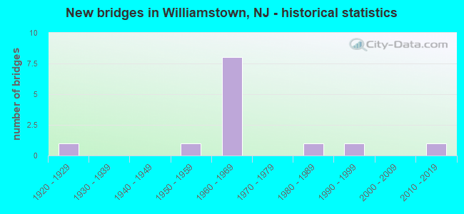
- New bridges - historical statistics
- 11920-1929
- 11950-1959
- 81960-1969
- 11980-1989
- 11990-1999
- 12010-2019

- Reconstructed bridges - Historical Statistics
- 11980-1989
- 01990-1999
- 12000-2009


- Bridge Condition - Deck
- 62.5%Good
- 25.0%Fair
- 12.5%Poor

- Bridge Condition - Superstructure
- 11.1%Very good
- 33.3%Good
- 33.3%Satisfactory
- 11.1%Fair
- 11.1%Poor

- Bridge Condition - Substructure
- 11.1%Very good
- 22.2%Good
- 55.6%Satisfactory
- 11.1%Poor

- Bridge Condition - Channel
- 42.9%Good
- 42.9%Satisfactory
- 14.3%Fair
Find on map >> Show street view
Structure Number: 411167, Location: 1.22 MI FROM RT 42 (Lat: 39.704689, Lng: -74.981419), Route carried "on" structure: Spur County highway 536S, Year Built: 1993, Status: Open, Structure Length: 0.67m (2.20ft), Average Daily Traffic: 17,612 (year 2021), Truck Traffic: 4%, Average Future Daily Traffic: 21,134 (year 2041), Features Intersected: Four Mile Branch, Facility Carried by Structure: (CR 556) Spur
Minimum Vertical Clearance: 30+ m (98+ ft), Kilometerpoint: 1.947, Lanes on structure: 2, Base Highway Network: Yes, Owner: County Highway Agency, Approaching Roadway Width: 15.2m (49.9ft), Skew: 2 degrees, Material/Design: Concrete, Design/Construction: Culvert, Number Of Spans In Main Unit: 2, Length of Maximum Span: 3.4m (11.2ft), Curb-To-Curb Width: 15.3m (50.2ft), Out-to-Out Width: 23.7m (77.8ft)
Condition: Channel: Good, Culverts: Satisfactory, Operating Rating: 54.4 metric tons, Method Used To Determine Operating Rating: Field evaluation and documented engineering judgment, Inventory Rating: 32.7 metric tons, Method Used To Determine Inventory Rating: Field evaluation and documented engineering judgment, Structural Evaluation: Equal to present minimum criteria, Deck Geometry: Superior to present desirable criteria, Waterway Adequacy: Better than present minimum criteria, Approach Roadway Alignment: Equal to present desirable criteria, Designated Inspection Frequency: Every 24 months, Inspection Date: April 2021
Find on map >> Show street view
Structure Number: 411F13, Location: 0.76 MI E OF MALAGA RD (Lat: 39.701531, Lng: -74.937581), Route carried "on" structure: County highway 536, Year Built: 1926, Year Reconstructed: 1986, Status: Open, Structure Length: 0.98m (3.22ft), Average Daily Traffic: 17,519 (year 2021), Truck Traffic: 4%, Average Future Daily Traffic: 21,023 (year 2041), Design Load: HS 20, Features Intersected: NEW BROOKLYN LAKE, Facility Carried by Structure: SICKLERVILLE RD
Minimum Vertical Clearance: 30+ m (98+ ft), Kilometerpoint: 44.917, Lanes on structure: 2, Owner: County Highway Agency, Approaching Roadway Width: 11.6m (38.1ft), Material/Design: Wood or Timber, Design/Construction: Slab, Number Of Spans In Main Unit: 1, Length of Maximum Span: 9.1m (29.9ft), Curb-To-Curb Width: 11.6m (38.1ft), Out-to-Out Width: 14.2m (46.6ft)
Condition: Deck: Fair, Superstructure: Fair, Substructure: Satisfactory, Channel: Good, Operating Rating: 58.1 metric tons, Method Used To Determine Operating Rating: Allowable Stress (AS), Inventory Rating: 39.9 metric tons, Method Used To Determine Inventory Rating: Allowable Stress (AS), Structural Evaluation: Somewhat better than minimum adequacy, Deck Geometry: Somewhat better than minimum adequacy, Waterway Adequacy: Superior to present desirable criteria, Approach Roadway Alignment: Better than present minimum criteria, Designated Inspection Frequency: Every 24 months, Inspection Date: March 2021, Deck Structure Type: Wood or Timber, Wearing Surface/Protective System: Wearing Surface: Bituminous, Membrane: Other
Find on map >> Show street view
Structure Number: 806N02, Location: 1.0 MI EAST OF RT 536 (Lat: 39.702219, Lng: -74.969400), Route carried "on" structure: ServiceCity street , Year Built: 1952, Status: Posted for load, Structure Length: 0.76m (2.49ft), Average Daily Traffic: 4 (year 2020), Truck Traffic: 1%, Average Future Daily Traffic: 5 (year 2040), Features Intersected: FOUR MILE BRANCH, Facility Carried by Structure: ANDREWS ROAD
Minimum Vertical Clearance: 30+ m (98+ ft), Kilometerpoint: 0.000, Lanes on structure: 2, Owner: County Highway Agency, Approaching Roadway Width: 3.7m (12.1ft), Material/Design: Wood or Timber, Design/Construction: Stringer/Multi-beam, Number Of Spans In Main Unit: 2, Length of Maximum Span: 3.7m (12.1ft), Curb-To-Curb Width: 9.1m (29.9ft), Out-to-Out Width: 9.8m (32.2ft)
Condition: Deck: Poor, Superstructure: Poor, Substructure: Poor, Channel: Satisfactory, Operating Rating: 10.9 metric tons, Method Used To Determine Operating Rating: Allowable Stress (AS), Inventory Rating: 7.3 metric tons, Method Used To Determine Inventory Rating: Allowable Stress (AS), Structural Evaluation: High priority of replacement, Deck Geometry: Better than present minimum criteria, Waterway Adequacy: Equal to present minimum criteria, Approach Roadway Alignment: Better than present minimum criteria, Bridge Posting: Required (Relationship of Operating Rating to Maximum Legal Load: > 39.9% below), Length Of Structure Improvement: 1.37m (4.49ft), Designated Inspection Frequency: Every 24 months, Other Special Inspection Frequency: Every 12 months, Inspection Date: May 2020, Other Special Inspection Date: May 2021, Bridge Improvement Cost: $775,000, Roadway Improvement Cost: $100,000, Total Project Cost: $1,276,000 ( Estimate for 2020), Deck Structure Type: Wood or Timber, Wearing Surface/Protective System: Wearing Surface: Bituminous
Find on map >> Show street view
Structure Number: 806N03, Location: 0.1mi West of RT 536 SPUR (Lat: 39.704350, Lng: -74.984089), Route carried "on" structure: City street , Year Built: 1988, Status: Open, Structure Length: 0.73m (2.40ft), Average Daily Traffic: 1,535 (year 2020), Truck Traffic: 1%, Average Future Daily Traffic: 1,842 (year 2040), Design Load: HS 20, Features Intersected: LOGGERHEAD BRANCH, Facility Carried by Structure: HOLIDAY CITY BLVD.
Minimum Vertical Clearance: 30+ m (98+ ft), Kilometerpoint: 0.000, Lanes on structure: 2, Owner: County Highway Agency, Approaching Roadway Width: 10.4m (34.1ft), Skew: 2 degrees, Material/Design: Aluminum, Iron, Design/Construction: Arch - Deck, Number Of Spans In Main Unit: 1, Length of Maximum Span: 6.7m (22.0ft), Curb or Sidewalk Widths: Left: 1.5m (4.9ft), Right: 1.4m (4.6ft), Curb-To-Curb Width: 10.5m (34.4ft), Out-to-Out Width: 14.0m (45.9ft)
Condition: Superstructure: Good, Substructure: Good, Channel: Good, Operating Rating: 49.0 metric tons, Method Used To Determine Operating Rating: Load Factor (LF), Inventory Rating: 29.0 metric tons, Method Used To Determine Inventory Rating: Load Factor (LF), Structural Evaluation: Better than present minimum criteria, Deck Geometry: Equal to present minimum criteria, Waterway Adequacy: Better than present minimum criteria, Approach Roadway Alignment: Equal to present desirable criteria, Designated Inspection Frequency: Every 24 months, Inspection Date: May 2020
Find on map >> Show street view
Structure Number: 807P01, Location: 2.25 mi EAST of CR 659 (Lat: 39.669489, Lng: -74.913300), Route carried "on" structure: Other road , Year Built: 2010, Status: Open, Structure Length: 2.35m (7.71ft), Average Daily Traffic: 2,600 (year 2020), Truck Traffic: 3%, Average Future Daily Traffic: 3,120 (year 2040), Design Load: HS 25 or greater, Features Intersected: GREAT EGG HARBOR RIVER, Facility Carried by Structure: WILLIAMS-WINSL RD
Minimum Vertical Clearance: 30+ m (98+ ft), Kilometerpoint: 0.002, Lanes on structure: 2, Owner: County Highway Agency, Approaching Roadway Width: 10.7m (35.1ft), Skew: 2 degrees, Material/Design: Prestressed concrete, Design/Construction: Box Beam or Girders - Multiple, Number Of Spans In Main Unit: 1, Length of Maximum Span: 22.6m (74.1ft), Curb-To-Curb Width: 11.4m (37.4ft), Out-to-Out Width: 12.4m (40.7ft)
Condition: Deck: Good, Superstructure: Very good, Substructure: Very good, Channel: Satisfactory, Operating Rating: 76.2 metric tons, Method Used To Determine Operating Rating: Load Factor (LF), Inventory Rating: 45.4 metric tons, Method Used To Determine Inventory Rating: Load Factor (LF), Structural Evaluation: Equal to present desirable criteria, Deck Geometry: Somewhat better than minimum adequacy, Waterway Adequacy: Better than present minimum criteria, Approach Roadway Alignment: Equal to present desirable criteria, Designated Inspection Frequency: Every 24 months, Inspection Date: May 2020, Deck Structure Type: Concrete Cast-file-Place, Wearing Surface/Protective System: Wearing Surface: Monolithic Concrete, Deck Protection: Epoxy Coated Reinforcing
Find on map >> Show street view
Structure Number: 350359N, Location: 0.25 MI SE OF ACE&RT536 J (Lat: 39.696669, Lng: -74.935000), Route carried "on" structure: Other road ACE, Year Built: 1964, Status: Open, Structure Length: 2.50m (8.20ft), Average Daily Traffic: 37,130 (year 2006), Truck Traffic: 7%, Average Future Daily Traffic: 51,000 (year 2026), Design Load: HS 20, Features Intersected: GREAT EGG HARBOR RIVER, Facility Carried by Structure: A.C. EXPRESSWAY WB
Minimum Vertical Clearance: 30+ m (98+ ft), Kilometerpoint: 57.775, Lanes on structure: 2, Base Highway Network: Yes, Toll: On toll road, Owner: State Toll Authority, Maintenance Responsibility: Private, Approaching Roadway Width: 14.6m (47.9ft), Skew: 2 degrees, Material/Design: Prestressed concrete, Design/Construction: Stringer/Multi-beam, Number Of Spans In Main Unit: 1, Length of Maximum Span: 22.9m (75.1ft), Curb or Sidewalk Widths: Left: 0.5m (1.6ft), Right: 0.5m (1.6ft), Curb-To-Curb Width: 10.1m (33.1ft), Out-to-Out Width: 11.8m (38.7ft)
Condition: Deck: Good, Superstructure: Satisfactory, Substructure: Good, Channel: Fair, Operating Rating: 89.8 metric tons, Method Used To Determine Operating Rating: Load Factor (LF), Inventory Rating: 29.0 metric tons, Method Used To Determine Inventory Rating: Load Factor (LF), Structural Evaluation: Equal to present minimum criteria, Deck Geometry: Somewhat better than minimum adequacy, Waterway Adequacy: Equal to present desirable criteria, Approach Roadway Alignment: Equal to present desirable criteria, Designated Inspection Frequency: Every 24 months, Inspection Date: March 2020, Deck Structure Type: Concrete Cast-file-Place, Wearing Surface/Protective System: Wearing Surface: Bituminous
Find on map >> Show street view
Structure Number: 350359S, Location: 0.25 MI SE OF ACE&RT536 J (Lat: 39.696669, Lng: -74.935000), Route carried "on" structure: Other road ACE, Year Built: 1964, Status: Open, Structure Length: 2.50m (8.20ft), Average Daily Traffic: 37,130 (year 2006), Truck Traffic: 7%, Average Future Daily Traffic: 51,000 (year 2026), Design Load: HS 20, Features Intersected: GREAT EGG HARBOR RIVER, Facility Carried by Structure: A.C. EXPRESSWAY EB
Minimum Vertical Clearance: 30+ m (98+ ft), Kilometerpoint: 57.775, Lanes on structure: 2, Base Highway Network: Yes, Toll: On toll road, Owner: State Toll Authority, Approaching Roadway Width: 14.6m (47.9ft), Skew: 2 degrees, Material/Design: Prestressed concrete, Design/Construction: Stringer/Multi-beam, Number Of Spans In Main Unit: 1, Length of Maximum Span: 22.9m (75.1ft), Curb or Sidewalk Widths: Left: 0.5m (1.6ft), Right: 0.5m (1.6ft), Curb-To-Curb Width: 10.1m (33.1ft), Out-to-Out Width: 11.8m (38.7ft)
Condition: Deck: Good, Superstructure: Good, Substructure: Satisfactory, Channel: Satisfactory, Operating Rating: 89.8 metric tons, Method Used To Determine Operating Rating: Load Factor (LF), Inventory Rating: 29.0 metric tons, Method Used To Determine Inventory Rating: Load Factor (LF), Structural Evaluation: Equal to present minimum criteria, Deck Geometry: Somewhat better than minimum adequacy, Waterway Adequacy: Equal to present desirable criteria, Approach Roadway Alignment: Equal to present desirable criteria, Designated Inspection Frequency: Every 24 months, Inspection Date: March 2020, Deck Structure Type: Concrete Cast-file-Place, Wearing Surface/Protective System: Wearing Surface: Bituminous
Find on map >> Show street view
Structure Number: 350362, Location: AT ACE & CO RT 536 JCT (Lat: 39.698331, Lng: -74.940000), Route carried "on" structure: County highway 536, Year Built: 1963, Status: Open, Structure Length: 6.68m (21.92ft), Average Daily Traffic: 18,910 (year 2012), Truck Traffic: 4%, Average Future Daily Traffic: 27,180 (year 2032), Design Load: HS 20, Features Intersected: ATLANTIC CITY EXPRESSWAY, Facility Carried by Structure: NEW BROOKLYN ROAD
Minimum Vertical Clearance: 30+ m (98+ ft), Kilometerpoint: 44.370, Lanes on structure: 2, Lanes under structure: 4, Owner: State Toll Authority, Maintenance Responsibility: Private, Approaching Roadway Width: 11.0m (36.1ft), Skew: 3 degrees, Material/Design: Steel, Design/Construction: Stringer/Multi-beam, Number Of Spans In Main Unit: 4, Length of Maximum Span: 22.3m (73.2ft), Curb or Sidewalk Widths: Left: 1.8m (5.9ft), Right: 1.8m (5.9ft), Curb-To-Curb Width: 11.0m (36.1ft), Out-to-Out Width: 15.7m (51.5ft)
Condition: Deck: Good, Superstructure: Good, Substructure: Satisfactory, Operating Rating: 53.5 metric tons, Method Used To Determine Operating Rating: Load Factor (LF), Inventory Rating: 32.7 metric tons, Method Used To Determine Inventory Rating: Load Factor (LF), Structural Evaluation: Equal to present minimum criteria, Deck Geometry: Meets minimum limits, Underclear: Equal to present minimum criteria, Approach Roadway Alignment: Better than present minimum criteria, Length Of Structure Improvement: 6.70m (21.98ft), Designated Inspection Frequency: Every 24 months, Inspection Date: March 2020, Deck Structure Type: Concrete Cast-file-Place, Wearing Surface/Protective System: Wearing Surface: Monolithic Concrete
Find on map >> Show street view
Structure Number: 350384, Location: 1.5 MI NE OF RT42&610 JCT (Lat: 39.708331, Lng: -74.978331), Route carried "on" structure: Spur County highway 536, Year Built: 1964, Status: Open, Structure Length: 5.00m (16.40ft), Average Daily Traffic: 14,076 (year 2006), Truck Traffic: 4%, Average Future Daily Traffic: 20,800 (year 2026), Design Load: H 20, Features Intersected: ATLANTIC CITY EXPRESSWAY, Facility Carried by Structure: WMSTWN-N FRDM RD
Minimum Vertical Clearance: 30+ m (98+ ft), Kilometerpoint: 2.478, Lanes on structure: 2, Lanes under structure: 4, Base Highway Network: Yes, Owner: State Toll Authority, Maintenance Responsibility: Private, Approaching Roadway Width: 11.0m (36.1ft), Material/Design: Prestressed concrete, Design/Construction: Stringer/Multi-beam, Number Of Spans In Main Unit: 4, Length of Maximum Span: 17.4m (57.1ft), Curb or Sidewalk Widths: Left: 1.8m (5.9ft), Right: 1.8m (5.9ft), Curb-To-Curb Width: 11.0m (36.1ft), Out-to-Out Width: 15.4m (50.5ft)
Condition: Deck: Fair, Superstructure: Satisfactory, Substructure: Satisfactory, Operating Rating: 89.8 metric tons, Method Used To Determine Operating Rating: Load Factor (LF), Inventory Rating: 39.9 metric tons, Method Used To Determine Inventory Rating: Load Factor (LF), Structural Evaluation: Equal to present minimum criteria, Deck Geometry: Meets minimum limits, Underclear: High priority of corrective action, Approach Roadway Alignment: Equal to present minimum criteria, Length Of Structure Improvement: 5.00m (16.40ft), Designated Inspection Frequency: Every 24 months, Inspection Date: March 2020, Total Project Cost: $1,899,000 ( Estimate for 2018), Deck Structure Type: Concrete Cast-file-Place, Wearing Surface/Protective System: Wearing Surface: Monolithic Concrete
Find on map >> Show street view
Structure Number: 350407, Location: 1 MI NE OF RT42&689 JCT (Lat: 39.733331, Lng: -75.008331), Route carried "on" structure: County highway 689, Year Built: 1964, Year Reconstructed: 2000, Status: Open, Structure Length: 5.12m (16.80ft), Average Daily Traffic: 17,147 (year 2012), Truck Traffic: 4%, Average Future Daily Traffic: 24,670 (year 2032), Design Load: HS 20, Features Intersected: ATLANTIC CITY EXPRESSWAY, Facility Carried by Structure: BERLIN-CRS KEYS RD
Minimum Vertical Clearance: 30+ m (98+ ft), Kilometerpoint: 0.998, Lanes on structure: 6, Lanes under structure: 4, Owner: State Toll Authority, Maintenance Responsibility: Private, Approaching Roadway Width: 23.8m (78.1ft), Skew: 1 degrees, Material/Design: Prestressed concrete, Design/Construction: Stringer/Multi-beam, Number Of Spans In Main Unit: 4, Length of Maximum Span: 17.4m (57.1ft), Curb or Sidewalk Widths: Left: 1.8m (5.9ft), Right: 1.8m (5.9ft), Curb-To-Curb Width: 23.8m (78.1ft), Out-to-Out Width: 28.0m (91.9ft)
Condition: Deck: Good, Superstructure: Satisfactory, Substructure: Satisfactory, Inventory Rating: 37.2 metric tons, Method Used To Determine Inventory Rating: Load Factor (LF), Structural Evaluation: Equal to present minimum criteria, Deck Geometry: Somewhat better than minimum adequacy, Underclear: Meets minimum limits, Approach Roadway Alignment: Better than present minimum criteria, Length Of Structure Improvement: 3.90m (12.80ft), Designated Inspection Frequency: Every 24 months, Inspection Date: March 2020, Deck Structure Type: Concrete Cast-file-Place, Wearing Surface/Protective System: Wearing Surface: Bituminous
Find on map >> Show street view
Structure Number: 350362, Location: AT ACE & CO RT 536 JCT (Lat: 39.698331, Lng: -74.940000), Route carried "under" structure: Other road ACE, Year Built: 1963, Structure Length: 0. m, Average Daily Traffic: 84,431 (year 2012), Truck Traffic: 5%, Features Intersected: ATLANTIC CITY EXPRESSWAY, Facility Carried by Structure: NEW BROOKLYN ROAD
Minimum Vertical Clearance: 4.44m (14.57ft), Kilometerpoint: 58.339, Lanes on structure: 2, Lanes under structure: 4, Material/Design: Steel, Design/Construction: Stringer/Multi-beam, Length of Maximum Span: 22.3m (73.2ft)
Find on map >> Show street view
Structure Number: 350384, Location: 1.5 MI NE OF RT42&610 JCT (Lat: 39.708331, Lng: -74.978331), Route carried "under" structure: Other road ACE, Year Built: 1964, Structure Length: 0. m, Average Daily Traffic: 69,360 (year 2006), Truck Traffic: 5%, Features Intersected: ATLANTIC CITY EXPRESSWAY, Facility Carried by Structure: WMSTWN-N FRDM RD
Minimum Vertical Clearance: 4.32m (14.17ft), Kilometerpoint: 61.799, Lanes on structure: 2, Lanes under structure: 4, Material/Design: Prestressed concrete, Design/Construction: Stringer/Multi-beam, Length of Maximum Span: 17.4m (57.1ft)
Find on map >> Show street view
Structure Number: 350407, Location: 1 MI NE OF RT42&689 JCT (Lat: 39.733331, Lng: -75.008331), Route carried "under" structure: Other road ACE, Year Built: 1964, Structure Length: 0. m, Average Daily Traffic: 85,995 (year 2012), Truck Traffic: 5%, Features Intersected: ATLANTIC CITY EXPRESSWAY, Facility Carried by Structure: BERLIN-CRS KEYS RD
Minimum Vertical Clearance: 4.60m (15.09ft), Kilometerpoint: 65.500, Lanes on structure: 6, Lanes under structure: 4, Material/Design: Prestressed concrete, Design/Construction: Stringer/Multi-beam, Length of Maximum Span: 17.4m (57.1ft)