Bridge Statistics for White Meadow Lake, New Jersey (NJ)
Condition, Traffic, Stress, Structural Evaluation, Project Costs
- National Bridge Inventory (NBI) Statistics
- 18Number of bridges
- 125ft / 37.9mTotal length
- $782,000Total costs
- 675,957Total average daily traffic
- 57,739Total average daily truck traffic
- National Bridge Inventory (NBI) Registered Bridges for White Meadow Lake
- No street view available for this location
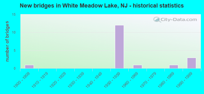
- New bridges - historical statistics
- 11900-1909
- 121950-1959
- 11960-1969
- 11980-1989
- 31990-1999

- Reconstructed bridges - Historical Statistics
- 81980-1989
- 01990-1999
- 02000-2009
- 02010-2019
- 12020-2022


- Bridge Condition - Deck
- 9.1%Very good
- 81.8%Good
- 9.1%Satisfactory

- Bridge Condition - Superstructure
- 18.2%Good
- 54.5%Satisfactory
- 27.3%Fair

- Bridge Condition - Substructure
- 9.1%Good
- 54.5%Satisfactory
- 36.4%Fair

- Bridge Condition - Channel
- 33.3%Good
- 33.3%Satisfactory
- 33.3%Fair

- Bridge Condition - Culverts
- 50.0%Good
- 50.0%Satisfactory
Find on map >> Show street view
Structure Number: 140084, Location: 1.97 miles north of NJ 15 (Lat: 40.954111, Lng: -74.570831), Route carried "on" structure: County highway 699, Year Built: 1997, Status: Open, Structure Length: 2.10m (6.89ft), Average Daily Traffic: 10,434 (year 2021), Truck Traffic: 3%, Average Future Daily Traffic: 12,520 (year 2041), Design Load: HS 25 or greater, Features Intersected: ROCKAWAY RIVER, Facility Carried by Structure: BERKSHIRE VALLEYRD
Minimum Vertical Clearance: 30+ m (98+ ft), Kilometerpoint: 3.170, Lanes on structure: 2, Owner: County Highway Agency, Approaching Roadway Width: 8.5m (27.9ft), Material/Design: Steel, Design/Construction: Truss - Thru, Number Of Spans In Main Unit: 1, Length of Maximum Span: 20.4m (66.9ft), Curb or Sidewalk Widths: Left: 1.5m (4.9ft), Right: 1.5m (4.9ft), Curb-To-Curb Width: 8.5m (27.9ft), Out-to-Out Width: 9.0m (29.5ft)
Condition: Deck: Good, Superstructure: Fair, Substructure: Good, Channel: Satisfactory, Operating Rating: 48.1 metric tons, Method Used To Determine Operating Rating: Load Factor (LF), Inventory Rating: 18.1 metric tons, Method Used To Determine Inventory Rating: Load Factor (LF), Structural Evaluation: Meets minimum limits, Deck Geometry: High priority of replacement, Waterway Adequacy: Superior to present desirable criteria, Approach Roadway Alignment: Equal to present desirable criteria, Designated Inspection Frequency: Every 24 months, Critical Feature Inspection Frequency: Every 24 months, Inspection Date: August 2021, Critical Feature Inspection Date: August 2021, Deck Structure Type: Concrete Cast-file-Place, Wearing Surface/Protective System: Wearing Surface: Monolithic Concrete, Deck Protection: Epoxy Coated Reinforcing
Find on map >> Show street view
Structure Number: 1400903, Location: 150' EAST OF CR 513 (Lat: 40.930400, Lng: -74.486969), Route carried "on" structure: City street , Year Built: 1960, Status: Open, Structure Length: 1.49m (4.89ft), Average Daily Traffic: 2,846 (year 2021), Truck Traffic: 3%, Average Future Daily Traffic: 3,415 (year 2041), Features Intersected: HIBERNIA BROOK, Facility Carried by Structure: MERIDEN ROAD
Minimum Vertical Clearance: 30+ m (98+ ft), Kilometerpoint: 0.064, Lanes on structure: 2, Owner: County Highway Agency, Approaching Roadway Width: 8.5m (27.9ft), Skew: 4 degrees, Material/Design: Steel, Design/Construction: Stringer/Multi-beam, Number Of Spans In Main Unit: 1, Length of Maximum Span: 13.7m (44.9ft), Curb or Sidewalk Widths: Left: 0.9m (3.0ft), Right: 0.0m, Curb-To-Curb Width: 9.1m (29.9ft), Out-to-Out Width: 10.7m (35.1ft)
Condition: Deck: Satisfactory, Superstructure: Fair, Substructure: Fair, Channel: Good, Operating Rating: 33.6 metric tons, Method Used To Determine Operating Rating: Load Factor (LF), Inventory Rating: 20.0 metric tons, Method Used To Determine Inventory Rating: Load Factor (LF), Structural Evaluation: Somewhat better than minimum adequacy, Deck Geometry: Meets minimum limits, Waterway Adequacy: Superior to present desirable criteria, Approach Roadway Alignment: Equal to present desirable criteria, Designated Inspection Frequency: Every 24 months, Inspection Date: July 2021, Deck Structure Type: Closed Grating, Wearing Surface/Protective System: Wearing Surface: Bituminous
Find on map >> Show street view
Structure Number: 1400904, Location: 2MI NE OF I-80&CR513 JCT (Lat: 40.931431, Lng: -74.479589), Route carried "on" structure: City street , Year Built: 1986, Year Reconstructed: 2020, Status: Posted for load, Structure Length: 0.82m (2.69ft), Average Daily Traffic: 152 (year 2021), Truck Traffic: 1%, Average Future Daily Traffic: 185 (year 2041), Features Intersected: BEAVER BROOK, Facility Carried by Structure: OLD BEACH GLEN RD
Minimum Vertical Clearance: 30+ m (98+ ft), Kilometerpoint: 0.000, Lanes on structure: 2, Owner: County Highway Agency, Approaching Roadway Width: 6.1m (20.0ft), Material/Design: Steel, Design/Construction: Stringer/Multi-beam, Number Of Spans In Main Unit: 1, Length of Maximum Span: 7.0m (23.0ft), Curb or Sidewalk Widths: Left: 0.3m (1.0ft), Right: 0.3m (1.0ft), Curb-To-Curb Width: 6.4m (21.0ft), Out-to-Out Width: 7.6m (24.9ft)
Condition: Deck: Good, Superstructure: Good, Substructure: Satisfactory, Channel: Fair, Inventory Rating: 88.0 metric tons, Method Used To Determine Inventory Rating: Load Factor (LF), Structural Evaluation: Equal to present minimum criteria, Deck Geometry: Meets minimum limits, Waterway Adequacy: Superior to present desirable criteria, Approach Roadway Alignment: Better than present minimum criteria, Length Of Structure Improvement: 0.82m (2.69ft), Designated Inspection Frequency: Every 24 months, Inspection Date: August 2021, Bridge Improvement Cost: $140,000, Total Project Cost: $140,000 ( Estimate for 2019), Deck Structure Type: Corrugated Steel, Wearing Surface/Protective System: Wearing Surface: Bituminous
Find on map >> Show street view
Structure Number: 1400907, Location: 0.5MI NE OF I-80 EXIT 37 (Lat: 40.912269, Lng: -74.494069), Route carried "on" structure: City street , Year Built: 1900, Year Reconstructed: 1992, Status: Open, Structure Length: 0.98m (3.22ft), Average Daily Traffic: 5,013 (year 2021), Truck Traffic: 1%, Average Future Daily Traffic: 6,117 (year 2041), Design Load: HS 20+Mod, Features Intersected: BEAVER BROOK, Facility Carried by Structure: FORD ROAD
Minimum Vertical Clearance: 30+ m (98+ ft), Kilometerpoint: 0.000, Lanes on structure: 2, Owner: County Highway Agency, Approaching Roadway Width: 5.5m (18.0ft), Material/Design: Prestressed concrete, Design/Construction: Box Beam or Girders - Multiple, Number Of Spans In Main Unit: 1, Length of Maximum Span: 8.5m (27.9ft), Curb-To-Curb Width: 5.5m (18.0ft), Out-to-Out Width: 6.6m (21.7ft)
Condition: Deck: Good, Superstructure: Good, Substructure: Satisfactory, Channel: Fair, Structural Evaluation: Equal to present minimum criteria, Deck Geometry: High priority of replacement, Waterway Adequacy: Equal to present desirable criteria, Approach Roadway Alignment: Equal to present desirable criteria, Length Of Structure Improvement: 0.98m (3.22ft), Designated Inspection Frequency: Every 24 months, Inspection Date: August 2021, Bridge Improvement Cost: $260,000, Roadway Improvement Cost: $24,000, Total Project Cost: $479,000 ( Estimate for 2021), Deck Structure Type: Concrete Cast-file-Place, Wearing Surface/Protective System: Wearing Surface: Monolithic Concrete, Deck Protection: Epoxy Coated Reinforcing
Find on map >> Show street view
Structure Number: 1400986, Location: 1 ML. N. OF I-80 EXIT 37 (Lat: 40.921011, Lng: -74.503839), Route carried "on" structure: City street , Year Built: 1992, Status: Open, Structure Length: 0.85m (2.79ft), Average Daily Traffic: 228 (year 2021), Truck Traffic: 1%, Average Future Daily Traffic: 274 (year 2041), Design Load: HS 25 or greater, Features Intersected: Tributary to WhiteMeadow, Facility Carried by Structure: SHERBROOK DRIVE
Minimum Vertical Clearance: 30+ m (98+ ft), Kilometerpoint: 0.000, Lanes on structure: 2, Owner: County Highway Agency, Approaching Roadway Width: 11.0m (36.1ft), Skew: 4 degrees, Material/Design: Concrete, Design/Construction: Culvert, Number Of Spans In Main Unit: 1, Length of Maximum Span: 8.5m (27.9ft), Curb or Sidewalk Widths: Left: 1.2m (3.9ft), Right: 1.2m (3.9ft)
Condition: Channel: Satisfactory, Culverts: Satisfactory, Inventory Rating: 57.2 metric tons, Method Used To Determine Inventory Rating: Load Factor (LF), Structural Evaluation: Equal to present minimum criteria, Waterway Adequacy: Equal to present desirable criteria, Approach Roadway Alignment: Equal to present desirable criteria, Designated Inspection Frequency: Every 24 months, Inspection Date: July 2021
Find on map >> Show street view
Structure Number: 1400987, Location: 1 ML. N. OF I-80 EXIT 37 (Lat: 40.920411, Lng: -74.503931), Route carried "on" structure: City street , Year Built: 1993, Status: Open, Structure Length: 0.61m (2.00ft), Average Daily Traffic: 228 (year 2021), Truck Traffic: 1%, Average Future Daily Traffic: 274 (year 2041), Design Load: HS 25 or greater, Features Intersected: Trib White Meadow Brook, Facility Carried by Structure: Fernwood Drive
Minimum Vertical Clearance: 30+ m (98+ ft), Kilometerpoint: 0.000, Lanes on structure: 2, Owner: County Highway Agency, Approaching Roadway Width: 9.2m (30.2ft), Material/Design: Concrete, Design/Construction: Culvert, Number Of Spans In Main Unit: 1, Length of Maximum Span: 6.1m (20.0ft), Curb or Sidewalk Widths: Left: 1.2m (3.9ft), Right: 1.2m (3.9ft)
Condition: Channel: Good, Culverts: Good, Operating Rating: 70.8 metric tons, Method Used To Determine Operating Rating: Load Factor (LF), Inventory Rating: 42.6 metric tons, Method Used To Determine Inventory Rating: Load Factor (LF), Structural Evaluation: Better than present minimum criteria, Waterway Adequacy: Equal to present desirable criteria, Approach Roadway Alignment: Equal to present desirable criteria, Designated Inspection Frequency: Every 24 months, Inspection Date: July 2021
Find on map >> Show street view
Structure Number: 1413161, Location: 1.07 MI E OF I-80 EXIT 35 (Lat: 40.910831, Lng: -74.526811), Route carried "on" structure: County highway 664, Year Built: 1958, Year Reconstructed: 1985, Status: Open, Structure Length: 5.76m (18.90ft), Average Daily Traffic: 7,361 (year 2020), Truck Traffic: 3%, Average Future Daily Traffic: 8,833 (year 2040), Design Load: HS 20+Mod, Features Intersected: I-80, Facility Carried by Structure: MT HOPE-ROCKAWY RD
Minimum Vertical Clearance: 30+ m (98+ ft), Kilometerpoint: 1.674, Lanes on structure: 2, Lanes under structure: 8, Owner: State Highway Agency, Approaching Roadway Width: 9.1m (29.9ft), Skew: 2 degrees, Material/Design: Steel continuous, Design/Construction: Stringer/Multi-beam, Number Of Spans In Main Unit: 2, Length of Maximum Span: 28.0m (91.9ft), Curb or Sidewalk Widths: Left: 1.8m (5.9ft), Right: 1.8m (5.9ft), Curb-To-Curb Width: 9.2m (30.2ft), Out-to-Out Width: 13.6m (44.6ft)
Condition: Deck: Good, Superstructure: Satisfactory, Substructure: Satisfactory, Operating Rating: 59.0 metric tons, Method Used To Determine Operating Rating: Load Factor (LF), Inventory Rating: 35.4 metric tons, Method Used To Determine Inventory Rating: Load Factor (LF), Structural Evaluation: Equal to present minimum criteria, Deck Geometry: High priority of corrective action, Underclear: Somewhat better than minimum adequacy, Approach Roadway Alignment: Equal to present minimum criteria, Length Of Structure Improvement: 5.76m (18.90ft), Designated Inspection Frequency: Every 24 months, Inspection Date: May 2020, Bridge Improvement Cost: $113,000, Roadway Improvement Cost: $11,000, Total Project Cost: $163,000 ( Estimate for 2020), Deck Structure Type: Concrete Cast-file-Place, Wearing Surface/Protective System: Wearing Surface: Monolithic Concrete, Deck Protection: Epoxy Coated Reinforcing
Find on map >> Show street view
Structure Number: 1413162, Location: 0.86 MI W OF I-80 EXIT 37 (Lat: 40.910989, Lng: -74.519981), Route carried "on" structure: Interstate 80, Year Built: 1958, Year Reconstructed: 1991, Status: Open, Structure Length: 5.12m (16.80ft), Average Daily Traffic: 71,190 (year 2020), Truck Traffic: 9%, Average Future Daily Traffic: 85,428 (year 2040), Design Load: HS 20, Features Intersected: STONEY BROOK ROAD
Minimum Vertical Clearance: 30+ m (98+ ft), Kilometerpoint: 59.176, Lanes on structure: 4, Lanes under structure: 2, Base Highway Network: Yes, Owner: State Highway Agency, Approaching Roadway Width: 21.0m (68.9ft), Skew: 1 degrees, Material/Design: Prestressed concrete, Design/Construction: Stringer/Multi-beam, Number Of Spans In Main Unit: 3, Length of Maximum Span: 16.8m (55.1ft), Curb-To-Curb Width: 20.9m (68.6ft), Out-to-Out Width: 22.1m (72.5ft)
Condition: Deck: Good, Superstructure: Satisfactory, Substructure: Satisfactory, Operating Rating: 76.2 metric tons, Method Used To Determine Operating Rating: Load Factor (LF), Inventory Rating: 45.4 metric tons, Method Used To Determine Inventory Rating: Load Factor (LF), Structural Evaluation: Equal to present minimum criteria, Deck Geometry: Better than present minimum criteria, Underclear: Equal to present minimum criteria, Approach Roadway Alignment: Equal to present desirable criteria, Designated Inspection Frequency: Every 24 months, Inspection Date: March 2020, Deck Structure Type: Concrete Cast-file-Place, Wearing Surface/Protective System: Wearing Surface: Bituminous, Deck Protection: Epoxy Coated Reinforcing
Find on map >> Show street view
Structure Number: 1413163, Location: 1.44 MI E.OF I-80,EXIT 35 (Lat: 40.911369, Lng: -74.519511), Route carried "on" structure: Interstate 80, Year Built: 1958, Year Reconstructed: 1991, Status: Open, Structure Length: 5.12m (16.80ft), Average Daily Traffic: 73,812 (year 2020), Truck Traffic: 9%, Average Future Daily Traffic: 88,574 (year 2040), Design Load: HS 20, Features Intersected: STONEY BROOK ROAD
Minimum Vertical Clearance: 30+ m (98+ ft), Kilometerpoint: 59.176, Lanes on structure: 4, Lanes under structure: 2, Base Highway Network: Yes, Owner: State Highway Agency, Approaching Roadway Width: 20.7m (67.9ft), Skew: 1 degrees, Material/Design: Prestressed concrete, Design/Construction: Stringer/Multi-beam, Number Of Spans In Main Unit: 3, Length of Maximum Span: 16.8m (55.1ft), Curb-To-Curb Width: 20.9m (68.6ft), Out-to-Out Width: 22.1m (72.5ft)
Condition: Deck: Good, Superstructure: Satisfactory, Substructure: Satisfactory, Operating Rating: 76.2 metric tons, Method Used To Determine Operating Rating: Load Factor (LF), Inventory Rating: 45.4 metric tons, Method Used To Determine Inventory Rating: Load Factor (LF), Structural Evaluation: Equal to present minimum criteria, Deck Geometry: Better than present minimum criteria, Underclear: Somewhat better than minimum adequacy, Approach Roadway Alignment: Equal to present desirable criteria, Designated Inspection Frequency: Every 24 months, Inspection Date: March 2020, Deck Structure Type: Concrete Cast-file-Place, Wearing Surface/Protective System: Wearing Surface: Bituminous
Find on map >> Show street view
Structure Number: 1413166, Location: 2.3 MI E OF I-80 EXIT 35 (Lat: 40.909169, Lng: -74.503839), Route carried "on" structure: Interstate 80, Year Built: 1958, Year Reconstructed: 1991, Status: Open, Structure Length: 4.11m (13.48ft), Average Daily Traffic: 146,437 (year 2020), Truck Traffic: 9%, Average Future Daily Traffic: 175,724 (year 2040), Design Load: HS 20+Mod, Features Intersected: GREEN POND ROAD (RT 513)
Minimum Vertical Clearance: 30+ m (98+ ft), Kilometerpoint: 60.560, Lanes on structure: 5, Lanes under structure: 4, Base Highway Network: Yes, Owner: State Highway Agency, Approaching Roadway Width: 21.3m (69.9ft), Skew: 1 degrees, Material/Design: Prestressed concrete, Design/Construction: Stringer/Multi-beam, Number Of Spans In Main Unit: 3, Length of Maximum Span: 19.8m (65.0ft), Curb-To-Curb Width: 21.5m (70.5ft), Out-to-Out Width: 22.7m (74.5ft)
Condition: Deck: Very good, Superstructure: Satisfactory, Substructure: Satisfactory, Operating Rating: 78.0 metric tons, Method Used To Determine Operating Rating: Load Factor (LF), Inventory Rating: 47.2 metric tons, Method Used To Determine Inventory Rating: Load Factor (LF), Structural Evaluation: Equal to present minimum criteria, Deck Geometry: Meets minimum limits, Underclear: Meets minimum limits, Approach Roadway Alignment: Equal to present desirable criteria, Designated Inspection Frequency: Every 24 months, Inspection Date: May 2020, Deck Structure Type: Concrete Cast-file-Place, Wearing Surface/Protective System: Wearing Surface: Bituminous, Deck Protection: Epoxy Coated Reinforcing
Find on map >> Show street view
Structure Number: 1413167, Location: AT I-80 EXIT-37 (Lat: 40.909381, Lng: -74.503250), Route carried "on" structure: Interstate 80, Year Built: 1958, Year Reconstructed: 1991, Status: Open, Structure Length: 4.05m (13.29ft), Average Daily Traffic: 63,300 (year 2020), Truck Traffic: 9%, Average Future Daily Traffic: 77,226 (year 2040), Design Load: HS 20+Mod, Features Intersected: CR 513(GREEN POND RD)
Minimum Vertical Clearance: 30+ m (98+ ft), Kilometerpoint: 60.560, Lanes on structure: 5, Lanes under structure: 4, Base Highway Network: Yes, Owner: State Highway Agency, Approaching Roadway Width: 21.3m (69.9ft), Skew: 1 degrees, Material/Design: Prestressed concrete, Design/Construction: Stringer/Multi-beam, Number Of Spans In Main Unit: 3, Length of Maximum Span: 19.2m (63.0ft), Curb-To-Curb Width: 21.4m (70.2ft), Out-to-Out Width: 23.8m (78.1ft)
Condition: Deck: Good, Superstructure: Fair, Substructure: Fair, Operating Rating: 46.3 metric tons, Method Used To Determine Operating Rating: Load Factor (LF), Inventory Rating: 27.2 metric tons, Method Used To Determine Inventory Rating: Load Factor (LF), Structural Evaluation: Somewhat better than minimum adequacy, Deck Geometry: Meets minimum limits, Underclear: Meets minimum limits, Approach Roadway Alignment: Equal to present desirable criteria, Designated Inspection Frequency: Every 24 months, Inspection Date: April 2020, Deck Structure Type: Concrete Cast-file-Place, Wearing Surface/Protective System: Wearing Surface: Bituminous, Membrane: Other, Deck Protection: Epoxy Coated Reinforcing
Find on map >> Show street view
Structure Number: 1413168, Location: 0.1 MI E OF I-80 EXIT 37 (Lat: 40.908689, Lng: -74.502781), Route carried "on" structure: Interstate 80, Year Built: 1958, Year Reconstructed: 1991, Status: Open, Structure Length: 3.47m (11.38ft), Average Daily Traffic: 59,350 (year 2020), Truck Traffic: 9%, Average Future Daily Traffic: 72,407 (year 2040), Design Load: HS 20+Mod, Features Intersected: Morristown & Erie RR
Minimum Vertical Clearance: 30+ m (98+ ft), Kilometerpoint: 60.672, Lanes on structure: 4, Base Highway Network: Yes, Owner: State Highway Agency, Approaching Roadway Width: 21.3m (69.9ft), Material/Design: Prestressed concrete, Design/Construction: Stringer/Multi-beam, Number Of Spans In Main Unit: 3, Length of Maximum Span: 10.7m (35.1ft), Curb-To-Curb Width: 21.3m (69.9ft), Out-to-Out Width: 22.5m (73.8ft)
Condition: Deck: Good, Superstructure: Satisfactory, Substructure: Fair, Operating Rating: 38.1 metric tons, Method Used To Determine Operating Rating: Load Factor (LF), Inventory Rating: 22.7 metric tons, Method Used To Determine Inventory Rating: Load Factor (LF), Structural Evaluation: Somewhat better than minimum adequacy, Deck Geometry: Better than present minimum criteria, Underclear: Equal to present minimum criteria, Approach Roadway Alignment: Equal to present desirable criteria, Designated Inspection Frequency: Every 24 months, Inspection Date: April 2020, Deck Structure Type: Concrete Cast-file-Place, Wearing Surface/Protective System: Wearing Surface: Bituminous, Deck Protection: Epoxy Coated Reinforcing
Find on map >> Show street view
Structure Number: 1413169, Location: 1.2 MI WEST OF RTE 46 (Lat: 40.908869, Lng: -74.502181), Route carried "on" structure: Interstate 80, Year Built: 1958, Year Reconstructed: 1991, Status: Open, Structure Length: 3.44m (11.29ft), Average Daily Traffic: 63,300 (year 2020), Truck Traffic: 9%, Average Future Daily Traffic: 77,226 (year 2040), Design Load: HS 20+Mod, Features Intersected: Morristown & Erie RR
Minimum Vertical Clearance: 30+ m (98+ ft), Kilometerpoint: 60.672, Lanes on structure: 4, Base Highway Network: Yes, Owner: State Highway Agency, Approaching Roadway Width: 21.0m (68.9ft), Material/Design: Prestressed concrete, Design/Construction: Stringer/Multi-beam, Number Of Spans In Main Unit: 3, Length of Maximum Span: 10.7m (35.1ft), Curb-To-Curb Width: 21.2m (69.6ft), Out-to-Out Width: 22.4m (73.5ft)
Condition: Deck: Good, Superstructure: Satisfactory, Substructure: Fair, Operating Rating: 37.2 metric tons, Method Used To Determine Operating Rating: Load Factor (LF), Inventory Rating: 22.7 metric tons, Method Used To Determine Inventory Rating: Load Factor (LF), Structural Evaluation: Somewhat better than minimum adequacy, Deck Geometry: Better than present minimum criteria, Underclear: Equal to present minimum criteria, Approach Roadway Alignment: Equal to present desirable criteria, Designated Inspection Frequency: Every 24 months, Inspection Date: April 2020, Deck Structure Type: Concrete Cast-file-Place, Wearing Surface/Protective System: Wearing Surface: Bituminous, Deck Protection: Epoxy Coated Reinforcing
Find on map >> Show street view
Structure Number: 1413161, Location: 1.07 MI E OF I-80 EXIT 35 (Lat: 40.910831, Lng: -74.526811), Route carried "under" structure: Interstate 80, Year Built: 1958, Structure Length: 0. m, Average Daily Traffic: 146,437 (year 2020), Truck Traffic: 9%, Features Intersected: I-80, Facility Carried by Structure: MT HOPE-ROCKAWY RD
Minimum Vertical Clearance: 5.05m (16.57ft), Kilometerpoint: 58.580, Lanes on structure: 2, Lanes under structure: 8, Material/Design: Steel continuous, Design/Construction: Stringer/Multi-beam, Length of Maximum Span: 28.0m (91.9ft)
Find on map >> Show street view
Structure Number: 1413162, Location: 0.86 MI W OF I-80 EXIT 37 (Lat: 40.910989, Lng: -74.519981), Route carried "under" structure: City street , Year Built: 1958, Structure Length: 0. m, Average Daily Traffic: 1,830 (year 2020), Truck Traffic: 1%, Features Intersected: STONEY BROOK ROAD, Facility Carried by Structure: I-80 EASTBOUND
Minimum Vertical Clearance: 8.58m (28.15ft), Kilometerpoint: 0.000, Lanes on structure: 4, Lanes under structure: 2, Material/Design: Prestressed concrete, Design/Construction: Stringer/Multi-beam, Length of Maximum Span: 16.8m (55.1ft)
Find on map >> Show street view
Structure Number: 1413163, Location: 1.44 MI E.OF I-80,EXIT 35 (Lat: 40.911369, Lng: -74.519511), Route carried "under" structure: City street , Year Built: 1958, Structure Length: 0. m, Average Daily Traffic: 1,830 (year 2020), Truck Traffic: 1%, Features Intersected: STONEY BROOK ROAD, Facility Carried by Structure: I-80 WB
Minimum Vertical Clearance: 7.24m (23.75ft), Kilometerpoint: 0.000, Lanes on structure: 4, Lanes under structure: 2, Material/Design: Prestressed concrete, Design/Construction: Stringer/Multi-beam, Length of Maximum Span: 16.8m (55.1ft)
Find on map >> Show street view
Structure Number: 1413166, Location: 2.3 MI E OF I-80 EXIT 35 (Lat: 40.909169, Lng: -74.503839), Route carried "under" structure: County highway 513, Year Built: 1958, Structure Length: 0. m, Average Daily Traffic: 11,319 (year 2020), Truck Traffic: 4%, Features Intersected: GREEN POND ROAD (RT 513), Facility Carried by Structure: I-80 EB & RAMP F
Minimum Vertical Clearance: 5.00m (16.40ft), Kilometerpoint: 72.968, Lanes on structure: 5, Lanes under structure: 4, Material/Design: Prestressed concrete, Design/Construction: Stringer/Multi-beam, Length of Maximum Span: 19.8m (65.0ft)
Find on map >> Show street view
Structure Number: 1413167, Location: AT I-80 EXIT-37 (Lat: 40.909381, Lng: -74.503250), Route carried "under" structure: County highway 513, Year Built: 1958, Structure Length: 0. m, Average Daily Traffic: 10,890 (year 2020), Truck Traffic: 4%, Features Intersected: CR 513(GREEN POND RD), Facility Carried by Structure: I-80 WESTBOUND
Minimum Vertical Clearance: 5.00m (16.40ft), Kilometerpoint: 72.968, Lanes on structure: 5, Lanes under structure: 4, Material/Design: Prestressed concrete, Design/Construction: Stringer/Multi-beam, Length of Maximum Span: 19.2m (63.0ft)