Bridge Statistics for White Marsh, Maryland (MD)
Condition, Traffic, Stress, Structural Evaluation, Project Costs
- National Bridge Inventory (NBI) Statistics
- 19Number of bridges
- 177ft / 53.8mTotal length
- $788,000Total costs
- 759,992Total average daily traffic
- 67,157Total average daily truck traffic
- National Bridge Inventory (NBI) Registered Bridges for White Marsh
- No street view available for this location
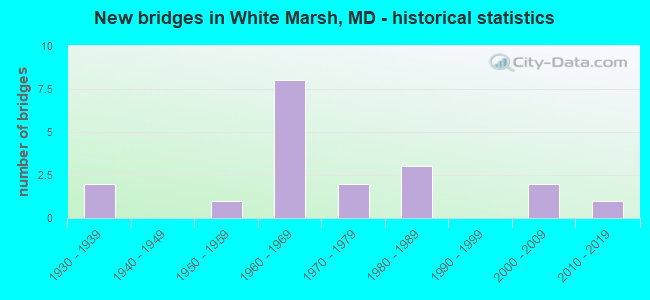
- New bridges - historical statistics
- 21930-1939
- 11950-1959
- 81960-1969
- 21970-1979
- 31980-1989
- 22000-2009
- 12010-2019

- Reconstructed bridges - Historical Statistics
- 21970-1979
- 01980-1989
- 11990-1999
- 32000-2009


- Bridge Condition - Deck
- 44.4%Good
- 44.4%Satisfactory
- 11.1%Fair

- Bridge Condition - Superstructure
- 40.0%Good
- 60.0%Satisfactory

- Bridge Condition - Substructure
- 30.0%Good
- 50.0%Satisfactory
- 20.0%Fair

- Bridge Condition - Channel
- 41.7%Good
- 41.7%Satisfactory
- 8.3%Fair
- 8.3%Poor

- Bridge Condition - Culverts
- 71.4%Satisfactory
- 28.6%Fair
Find on map >> Show street view
Structure Number: 10000003001402, Location: 0.07 MI S OF EBENEZER RD (Lat: 39.382708, Lng: -76.432975), Route carried "on" structure: State highway 7, Year Built: 1950, Status: Open, Structure Length: 0.82m (2.69ft), Average Daily Traffic: 16,450 (year 2009), Truck Traffic: 8%, Average Future Daily Traffic: 19,636 (year 2026), Design Load: H 20, Features Intersected: HONEYGO RUN
Minimum Vertical Clearance: 30+ m (98+ ft), Kilometerpoint: 11.479, Lanes on structure: 2, Owner: State Highway Agency, Approaching Roadway Width: 8.5m (27.9ft), Skew: 2 degrees, Material/Design: Concrete, Design/Construction: Culvert, Length of Maximum Span: 3.7m (12.1ft)
Condition: Channel: Satisfactory, Culverts: Satisfactory, Operating Rating: 59.9 metric tons, Method Used To Determine Operating Rating: Load Factor (LF), Inventory Rating: 35.8 metric tons, Method Used To Determine Inventory Rating: Load Factor (LF), Structural Evaluation: Equal to present minimum criteria, Waterway Adequacy: Equal to present desirable criteria, Approach Roadway Alignment: Equal to present desirable criteria, Designated Inspection Frequency: Every 24 months, Inspection Date: May 2021
Find on map >> Show street view
Structure Number: 10000003003601, Location: 0.36 MILE EAST OF MD 43 (Lat: 39.378408, Lng: -76.429350), Route carried "on" structure: US 40, Year Built: 1935, Year Reconstructed: 2006, Status: Open, Structure Length: 0.88m (2.89ft), Average Daily Traffic: 39,760 (year 2009), Truck Traffic: 8%, Average Future Daily Traffic: 44,310 (year 2026), Design Load: H 20, Features Intersected: HONEYGO RUN
Minimum Vertical Clearance: 30+ m (98+ ft), Kilometerpoint: 34.338, Lanes on structure: 5, Base Highway Network: Yes, Owner: State Highway Agency, Approaching Roadway Width: 35.4m (116.1ft), Skew: 30 degrees, Material/Design: Concrete, Design/Construction: Tee Beam, Number Of Spans In Main Unit: 1, Length of Maximum Span: 7.9m (25.9ft), Curb-To-Curb Width: 29.3m (96.1ft), Out-to-Out Width: 30.9m (101.4ft)
Condition: Deck: Satisfactory, Superstructure: Satisfactory, Substructure: Fair, Channel: Satisfactory, Operating Rating: 86.2 metric tons, Method Used To Determine Operating Rating: Load Factor (LF), Inventory Rating: 51.7 metric tons, Method Used To Determine Inventory Rating: Load Factor (LF), Structural Evaluation: Somewhat better than minimum adequacy, Deck Geometry: Superior to present desirable criteria, Waterway Adequacy: Superior to present desirable criteria, Approach Roadway Alignment: Equal to present desirable criteria, Designated Inspection Frequency: Every 24 months, Inspection Date: June 2021, Deck Structure Type: Concrete Cast-file-Place, Wearing Surface/Protective System: Wearing Surface: Bituminous
Find on map >> Show street view
Structure Number: 10000003003701, Location: 0.67 MILE WEST OF MD 43 (Lat: 39.365986, Lng: -76.439631), Route carried "on" structure: US 40, Year Built: 1935, Status: Open, Structure Length: 0.94m (3.08ft), Average Daily Traffic: 29,100 (year 2009), Truck Traffic: 8%, Average Future Daily Traffic: 33,829 (year 2026), Design Load: H 20, Features Intersected: WHITEMARSH RUN
Minimum Vertical Clearance: 30+ m (98+ ft), Kilometerpoint: 32.695, Lanes on structure: 4, Base Highway Network: Yes, Owner: State Highway Agency, Approaching Roadway Width: 28.7m (94.2ft), Material/Design: Concrete, Design/Construction: Tee Beam, Number Of Spans In Main Unit: 1, Length of Maximum Span: 8.5m (27.9ft), Curb-To-Curb Width: 24.4m (80.1ft), Out-to-Out Width: 25.5m (83.7ft)
Condition: Deck: Fair, Superstructure: Satisfactory, Substructure: Satisfactory, Channel: Fair, Operating Rating: 77.1 metric tons, Method Used To Determine Operating Rating: Load Factor (LF), Inventory Rating: 46.3 metric tons, Method Used To Determine Inventory Rating: Load Factor (LF), Structural Evaluation: Equal to present minimum criteria, Deck Geometry: Superior to present desirable criteria, Waterway Adequacy: Superior to present desirable criteria, Approach Roadway Alignment: Equal to present desirable criteria, Length Of Structure Improvement: 0.94m (3.08ft), Designated Inspection Frequency: Every 12 months, Inspection Date: December 2021, Bridge Improvement Cost: $156,000, Roadway Improvement Cost: $16,000, Total Project Cost: $172,000, Deck Structure Type: Concrete Cast-file-Place, Wearing Surface/Protective System: Wearing Surface: Bituminous
Find on map >> Show street view
Structure Number: 100000030216013, Location: 0.39 MILE EAST OF MD 7 (Lat: 39.374200, Lng: -76.433069), Route carried "on" structure: State highway 43, Year Built: 1968, Year Reconstructed: 2005, Status: Open, Structure Length: 7.80m (25.59ft), Average Daily Traffic: 8,100 (year 2006), Truck Traffic: 6%, Average Future Daily Traffic: 9,339 (year 2026), Design Load: HS 20, Features Intersected: US 40
Minimum Vertical Clearance: 30+ m (98+ ft), Kilometerpoint: 8.245, Lanes on structure: 2, Lanes under structure: 5, Owner: State Highway Agency, Approaching Roadway Width: 78.3m (256.9ft), Skew: 1 degrees, Material/Design: Steel, Design/Construction: Stringer/Multi-beam, Number Of Spans In Main Unit: 4, Length of Maximum Span: 22.3m (73.2ft), Curb-To-Curb Width: 12.6m (41.3ft), Out-to-Out Width: 14.4m (47.2ft)
Condition: Deck: Satisfactory, Superstructure: Satisfactory, Substructure: Fair, Inventory Rating: 57.1 metric tons, Method Used To Determine Inventory Rating: Load Factor (LF), Structural Evaluation: Somewhat better than minimum adequacy, Deck Geometry: Better than present minimum criteria, Underclear: Equal to present minimum criteria, Approach Roadway Alignment: Equal to present desirable criteria, Designated Inspection Frequency: Every 24 months, Inspection Date: June 2020, Deck Structure Type: Concrete Cast-file-Place, Wearing Surface/Protective System: Wearing Surface: Integral Concrete, Deck Protection: Epoxy Coated Reinforcing
Find on map >> Show street view
Structure Number: 100000030217013, Location: 0.08 MILE WEST OF US 40 (Lat: 39.374858, Lng: -76.434211), Route carried "on" structure: State highway 43, Year Built: 1963, Year Reconstructed: 1976, Status: Open, Structure Length: 4.20m (13.78ft), Average Daily Traffic: 24,493 (year 2012), Truck Traffic: 6%, Average Future Daily Traffic: 29,391 (year 2032), Design Load: HS 20, Features Intersected: CSX TRANSPORTATION
Minimum Vertical Clearance: 30+ m (98+ ft), Kilometerpoint: 8.117, Lanes on structure: 2, Base Highway Network: Yes, Owner: State Highway Agency, Approaching Roadway Width: 11.6m (38.1ft), Material/Design: Steel, Design/Construction: Stringer/Multi-beam, Number Of Spans In Main Unit: 3, Length of Maximum Span: 16.5m (54.1ft), Curb-To-Curb Width: 10.5m (34.4ft), Out-to-Out Width: 12.1m (39.7ft)
Condition: Deck: Satisfactory, Superstructure: Satisfactory, Substructure: Satisfactory, Inventory Rating: 54.4 metric tons, Method Used To Determine Inventory Rating: Load Factor (LF), Structural Evaluation: Equal to present minimum criteria, Deck Geometry: Meets minimum limits, Underclear: Better than present minimum criteria, Approach Roadway Alignment: Equal to present desirable criteria, Designated Inspection Frequency: Every 24 months, Inspection Date: January 2021, Deck Structure Type: Concrete Cast-file-Place, Wearing Surface/Protective System: Wearing Surface: Latex Concrete
Find on map >> Show street view
Structure Number: 100000030217014, Location: 0.08 MILE WEST OF US 40 (Lat: 39.374944, Lng: -76.433608), Route carried "on" structure: State highway 43, Year Built: 1963, Year Reconstructed: 2005, Status: Open, Structure Length: 4.36m (14.30ft), Average Daily Traffic: 22,608 (year 2012), Truck Traffic: 6%, Average Future Daily Traffic: 27,130 (year 2032), Design Load: HS 20, Features Intersected: CSX TRANSPORTATION
Minimum Vertical Clearance: 30+ m (98+ ft), Kilometerpoint: 8.117, Lanes on structure: 3, Base Highway Network: Yes, Owner: State Highway Agency, Approaching Roadway Width: 12.8m (42.0ft), Material/Design: Steel, Design/Construction: Stringer/Multi-beam, Number Of Spans In Main Unit: 3, Length of Maximum Span: 16.5m (54.1ft), Curb-To-Curb Width: 12.8m (42.0ft), Out-to-Out Width: 14.4m (47.2ft)
Condition: Deck: Satisfactory, Superstructure: Satisfactory, Substructure: Satisfactory, Operating Rating: 82.5 metric tons, Method Used To Determine Operating Rating: Load Factor (LF), Inventory Rating: 49.4 metric tons, Method Used To Determine Inventory Rating: Load Factor (LF), Structural Evaluation: Equal to present minimum criteria, Deck Geometry: High priority of replacement, Underclear: Better than present minimum criteria, Approach Roadway Alignment: Equal to present desirable criteria, Designated Inspection Frequency: Every 24 months, Inspection Date: January 2021, Deck Structure Type: Concrete Cast-file-Place, Wearing Surface/Protective System: Wearing Surface: Latex Concrete
Find on map >> Show street view
Structure Number: 10000003021801, Location: 0.52 M W OF BR NO 0301400 (Lat: 39.376725, Lng: -76.439081), Route carried "on" structure: State highway 7, Year Built: 1963, Year Reconstructed: 2002, Status: Open, Structure Length: 7.35m (24.11ft), Average Daily Traffic: 16,450 (year 0009), Truck Traffic: 8%, Average Future Daily Traffic: 19,636 (year 0026), Design Load: HS 20, Features Intersected: MD 43
Minimum Vertical Clearance: 30+ m (98+ ft), Kilometerpoint: 10.652, Lanes on structure: 3, Lanes under structure: 6, Owner: State Highway Agency, Approaching Roadway Width: 12.5m (41.0ft), Skew: 1 degrees, Material/Design: Steel, Design/Construction: Stringer/Multi-beam, Number Of Spans In Main Unit: 4, Length of Maximum Span: 24.1m (79.1ft), Curb or Sidewalk Widths: Left: 0.0m, Right: 1.6m (5.2ft), Curb-To-Curb Width: 13.0m (42.7ft), Out-to-Out Width: 15.5m (50.9ft)
Condition: Deck: Good, Superstructure: Satisfactory, Substructure: Satisfactory, Operating Rating: 67.6 metric tons, Method Used To Determine Operating Rating: Load Factor (LF), Inventory Rating: 40.4 metric tons, Method Used To Determine Inventory Rating: Load Factor (LF), Structural Evaluation: Equal to present minimum criteria, Deck Geometry: Meets minimum limits, Underclear: Meets minimum limits, Approach Roadway Alignment: Equal to present desirable criteria, Length Of Structure Improvement: 7.35m (24.11ft), Designated Inspection Frequency: Every 24 months, Inspection Date: April 2021, Bridge Improvement Cost: $560,000, Roadway Improvement Cost: $56,000, Total Project Cost: $616,000, Deck Structure Type: Concrete Cast-file-Place, Wearing Surface/Protective System: Wearing Surface: Monolithic Concrete
Find on map >> Show street view
Structure Number: 10000003030402, Location: 0.46 MILE WEST OF IS 95 (Lat: 39.379389, Lng: -76.457661), Route carried "on" structure: State highway 43, Year Built: 1979, Status: Open, Structure Length: 0.76m (2.49ft), Average Daily Traffic: 53,732 (year 2009), Truck Traffic: 8%, Average Future Daily Traffic: 57,929 (year 2026), Design Load: HS 20, Features Intersected: BRANCH OF WHITEMARSH RUN
Minimum Vertical Clearance: 30+ m (98+ ft), Kilometerpoint: 6.002, Lanes on structure: 8, Base Highway Network: Yes, Owner: State Highway Agency, Approaching Roadway Width: 51.8m (169.9ft), Material/Design: Concrete, Design/Construction: Culvert, Length of Maximum Span: 3.7m (12.1ft)
Condition: Channel: Good, Culverts: Satisfactory, Structural Evaluation: Equal to present minimum criteria, Waterway Adequacy: Equal to present desirable criteria, Approach Roadway Alignment: Equal to present desirable criteria, Designated Inspection Frequency: Every 24 months, Inspection Date: August 2020
Find on map >> Show street view
Structure Number: 200000B-011201, Location: 0.22 MI S OF US 40 (Lat: 39.378611, Lng: -76.425000), Route carried "on" structure: County highway 4095, Year Built: 1988, Status: Open, Structure Length: 5.09m (16.70ft), Average Daily Traffic: 12,715 (year 2021), Truck Traffic: 5%, Average Future Daily Traffic: 20,834 (year 2041), Design Load: HS 20, Features Intersected: WHITE MARSH RUN, Facility Carried by Structure: EBENEZER ROAD
Minimum Vertical Clearance: 30+ m (98+ ft), Kilometerpoint: 0.917, Lanes on structure: 2, Owner: County Highway Agency, Approaching Roadway Width: 11.0m (36.1ft), Material/Design: Prestressed concrete, Design/Construction: Box Beam or Girders - Multiple, Number Of Spans In Main Unit: 3, Length of Maximum Span: 16.8m (55.1ft), Curb-To-Curb Width: 11.0m (36.1ft), Out-to-Out Width: 11.9m (39.0ft)
Condition: Deck: Good, Superstructure: Good, Substructure: Satisfactory, Channel: Poor, Inventory Rating: 83.4 metric tons, Method Used To Determine Inventory Rating: Load Factor (LF), Structural Evaluation: Equal to present minimum criteria, Deck Geometry: Meets minimum limits, Waterway Adequacy: Better than present minimum criteria, Approach Roadway Alignment: Equal to present minimum criteria, Designated Inspection Frequency: Every 24 months, Inspection Date: June 2021, Wearing Surface/Protective System: Wearing Surface: Bituminous
Find on map >> Show street view
Structure Number: 200000B-017903, Location: 0.1 MI N WHITE MARSH BLVD (Lat: 39.382667, Lng: -76.470944), Route carried "on" structure: County highway 6198, Year Built: 1981, Status: Open, Structure Length: 1.22m (4.00ft), Average Daily Traffic: 21,216 (year 2021), Truck Traffic: 5%, Average Future Daily Traffic: 31,525 (year 2041), Design Load: HS 20, Features Intersected: WHITE MARSH RUN, Facility Carried by Structure: PERRY HALL BLVD
Minimum Vertical Clearance: 30+ m (98+ ft), Kilometerpoint: 0.563, Lanes on structure: 2, Owner: County Highway Agency, Approaching Roadway Width: 14.9m (48.9ft), Skew: 1 degrees, Material/Design: Steel, Design/Construction: Culvert, Length of Maximum Span: 3.0m (9.8ft)
Condition: Channel: Satisfactory, Culverts: Satisfactory, Structural Evaluation: Equal to present minimum criteria, Waterway Adequacy: Equal to present minimum criteria, Approach Roadway Alignment: Equal to present desirable criteria, Designated Inspection Frequency: Every 24 months, Inspection Date: November 2021
Find on map >> Show street view
Structure Number: 200000B-018503, Location: 0.3 MI SOUTH OF MD RTE 43 (Lat: 39.376389, Lng: -76.460306), Route carried "on" structure: County highway 6539, Year Built: 1980, Status: Open, Structure Length: 1.16m (3.81ft), Average Daily Traffic: 23,813 (year 2017), Truck Traffic: 5%, Average Future Daily Traffic: 27,060 (year 2039), Design Load: HS 20, Features Intersected: WHITE MARSH RUN, Facility Carried by Structure: HONEYGO BOULEVARD
Minimum Vertical Clearance: 30+ m (98+ ft), Kilometerpoint: 0.000, Lanes on structure: 6, Owner: County Highway Agency, Approaching Roadway Width: 31.4m (103.0ft), Material/Design: Steel, Design/Construction: Culvert, Length of Maximum Span: 11.6m (38.1ft)
Condition: Channel: Satisfactory, Culverts: Fair, Structural Evaluation: Somewhat better than minimum adequacy, Waterway Adequacy: Better than present minimum criteria, Approach Roadway Alignment: Equal to present desirable criteria, Designated Inspection Frequency: Every 24 months, Inspection Date: June 2021
Find on map >> Show street view
Structure Number: 200000B-029401, Location: 1.1 MI E OF PULASKY HWY (Lat: 39.371314, Lng: -76.410964), Route carried "on" structure: County highway 4095, Year Built: 2009, Status: Open, Structure Length: 2.44m (8.01ft), Average Daily Traffic: 9,700 (year 2013), Truck Traffic: 4%, Average Future Daily Traffic: 13,450 (year 2040), Features Intersected: WINDLASS RUN, Facility Carried by Structure: EBENEZER RD
Minimum Vertical Clearance: 30+ m (98+ ft), Kilometerpoint: 2.462, Lanes on structure: 2, Owner: County Highway Agency, Approaching Roadway Width: 13.4m (44.0ft), Material/Design: Prestressed concrete, Design/Construction: Stringer/Multi-beam, Number Of Spans In Main Unit: 1, Length of Maximum Span: 24.4m (80.1ft), Curb-To-Curb Width: 12.2m (40.0ft), Out-to-Out Width: 13.4m (44.0ft)
Condition: Deck: Good, Superstructure: Good, Substructure: Good, Channel: Good, Operating Rating: 88.4 metric tons, Method Used To Determine Operating Rating: Load Factor (LF), Inventory Rating: 53.1 metric tons, Method Used To Determine Inventory Rating: Load Factor (LF), Structural Evaluation: Better than present minimum criteria, Deck Geometry: Somewhat better than minimum adequacy, Waterway Adequacy: Superior to present desirable criteria, Approach Roadway Alignment: Equal to present desirable criteria, Designated Inspection Frequency: Every 24 months, Inspection Date: March 2020, Deck Structure Type: Concrete Cast-file-Place
Find on map >> Show street view
Structure Number: 200000B-037803, Location: .1 M E OF PERRY HALL BLVD (Lat: 39.385175, Lng: -76.468653), Route carried "on" structure: County highway , Year Built: 1975, Status: Open, Structure Length: 1.04m (3.41ft), Average Daily Traffic: 11,478 (year 2021), Truck Traffic: 5%, Average Future Daily Traffic: 14,005 (year 2041), Design Load: H 15, Features Intersected: TRIBUTARY OF WHITE MARSH, Facility Carried by Structure: BEACONSFIELD DRIVE
Minimum Vertical Clearance: 30+ m (98+ ft), Kilometerpoint: 0.000, Lanes on structure: 2, Owner: County Highway Agency, Approaching Roadway Width: 12.2m (40.0ft), Material/Design: Steel, Design/Construction: Culvert, Length of Maximum Span: 4.6m (15.1ft), Curb or Sidewalk Widths: Left: 1.5m (4.9ft), Right: 1.5m (4.9ft)
Condition: Channel: Good, Culverts: Fair, Structural Evaluation: Somewhat better than minimum adequacy, Waterway Adequacy: Better than present minimum criteria, Approach Roadway Alignment: Equal to present desirable criteria, Designated Inspection Frequency: Every 24 months, Inspection Date: July 2021
Find on map >> Show street view
Structure Number: 200000B-050001, Location: 1.0 MI E OF MD RT 1 (Lat: 39.377667, Lng: -76.487167), Route carried "on" structure: County highway 4198, Year Built: 2005, Status: Open, Structure Length: 1.04m (3.41ft), Average Daily Traffic: 2,500 (year 2014), Truck Traffic: 5%, Average Future Daily Traffic: 5,000 (year 2036), Design Load: HS 25 or greater, Features Intersected: UNNAMED STREAM, Facility Carried by Structure: WHITE MARSH RD
Minimum Vertical Clearance: 30+ m (98+ ft), Kilometerpoint: 0.885, Lanes on structure: 2, Owner: County Highway Agency, Approaching Roadway Width: 7.9m (25.9ft), Material/Design: Concrete, Design/Construction: Arch - Deck, Number Of Spans In Main Unit: 1, Length of Maximum Span: 10.1m (33.1ft), Curb or Sidewalk Widths: Left: 1.2m (3.9ft), Right: 0.0m, Curb-To-Curb Width: 8.2m (26.9ft), Out-to-Out Width: 12.7m (41.7ft)
Condition: Superstructure: Good, Substructure: Good, Channel: Satisfactory, Operating Rating: 81.2 metric tons, Method Used To Determine Operating Rating: Load Factor (LF), Inventory Rating: 58.0 metric tons, Method Used To Determine Inventory Rating: Load Factor (LF), Structural Evaluation: Better than present minimum criteria, Deck Geometry: High priority of corrective action, Waterway Adequacy: Better than present minimum criteria, Approach Roadway Alignment: Equal to present minimum criteria, Designated Inspection Frequency: Every 24 months, Inspection Date: November 2021, Deck Structure Type: Concrete Precast Panels, Wearing Surface/Protective System: Wearing Surface: Bituminous
Find on map >> Show street view
Structure Number: 300000B-X66602, Location: 0.44 MI S OF MD RTE 43 (Lat: 39.374222, Lng: -76.453814), Route carried "on" structure: Interstate 95, Year Built: 1962, Year Reconstructed: 1976, Status: Open, Structure Length: 1.31m (4.30ft), Average Daily Traffic: 181,802 (year 2019), Truck Traffic: 13%, Average Future Daily Traffic: 241,549 (year 2041), Design Load: HS 20, Features Intersected: WHITEMARSH RUN
Minimum Vertical Clearance: 30+ m (98+ ft), Kilometerpoint: 107.111, Lanes on structure: 9, Base Highway Network: Yes, Toll: On toll road, Owner: State Toll Authority, Approaching Roadway Width: 45.7m (149.9ft), Material/Design: Concrete, Design/Construction: Culvert, Number Of Spans In Main Unit: 3, Length of Maximum Span: 4.0m (13.1ft)
Condition: Channel: Good, Culverts: Satisfactory, Structural Evaluation: Equal to present minimum criteria, Waterway Adequacy: Equal to present desirable criteria, Approach Roadway Alignment: Equal to present desirable criteria, Designated Inspection Frequency: Every 24 months, Inspection Date: September 2021
Find on map >> Show street view
Structure Number: 300000B-X670013, Location: 0.57 MI W OF MD RTE 7 (Lat: 39.379506, Lng: -76.449497), Route carried "on" structure: State highway 43, Year Built: 2013, Status: Open, Structure Length: 12.48m (40.94ft), Average Daily Traffic: 31,500 (year 2019), Truck Traffic: 10%, Average Future Daily Traffic: 38,364 (year 2041), Design Load: HS 25 or greater, Features Intersected: I-95
Minimum Vertical Clearance: 30+ m (98+ ft), Kilometerpoint: 107.787, Lanes on structure: 3, Lanes under structure: 10, Owner: State Toll Authority, Approaching Roadway Width: 38.7m (127.0ft), Skew: 25 degrees, Material/Design: Steel continuous, Design/Construction: Stringer/Multi-beam, Number Of Spans In Main Unit: 3, Length of Maximum Span: 50.3m (165.0ft), Curb-To-Curb Width: 39.6m (129.9ft), Out-to-Out Width: 40.8m (133.9ft)
Condition: Deck: Good, Superstructure: Good, Substructure: Good, Operating Rating: 88.5 metric tons, Method Used To Determine Operating Rating: Load and Resistance Factor Rating (LRFR) rating reported by rating factor(RF) method using HL-93 loadings, Inventory Rating: 54.1 metric tons, Method Used To Determine Inventory Rating: Load and Resistance Factor Rating (LRFR) rating reported by rating factor(RF) method using HL-93 loadings, Structural Evaluation: Better than present minimum criteria, Deck Geometry: Superior to present desirable criteria, Underclear: High priority of corrective action, Approach Roadway Alignment: Equal to present desirable criteria, Designated Inspection Frequency: Every 24 months, Inspection Date: December 2021, Deck Structure Type: Concrete Cast-file-Place, Wearing Surface/Protective System: Wearing Surface: Monolithic Concrete, Deck Protection: Epoxy Coated Reinforcing
Find on map >> Show street view
Structure Number: 300000B-X67702, Location: 0.6 MI N OF MD 43 (Lat: 39.386211, Lng: -76.441139), Route carried "on" structure: Interstate 95, Year Built: 1963, Status: Open, Structure Length: 0.88m (2.89ft), Average Daily Traffic: 172,113 (year 2019), Truck Traffic: 12%, Average Future Daily Traffic: 228,677 (year 2041), Design Load: HS 20, Features Intersected: HONEYGO RUN
Minimum Vertical Clearance: 30+ m (98+ ft), Kilometerpoint: 108.929, Lanes on structure: 8, Base Highway Network: Yes, Toll: On toll road, Owner: State Toll Authority, Approaching Roadway Width: 43.9m (144.0ft), Material/Design: Concrete, Design/Construction: Culvert, Number Of Spans In Main Unit: 2, Length of Maximum Span: 3.7m (12.1ft)
Condition: Channel: Good, Culverts: Satisfactory, Operating Rating: 32.7 metric tons, Method Used To Determine Operating Rating: Field evaluation and documented engineering judgment, Inventory Rating: 32.7 metric tons, Method Used To Determine Inventory Rating: Field evaluation and documented engineering judgment, Structural Evaluation: Equal to present minimum criteria, Waterway Adequacy: Better than present minimum criteria, Approach Roadway Alignment: Equal to present desirable criteria, Designated Inspection Frequency: Every 24 months, Inspection Date: September 2021
Find on map >> Show street view
Structure Number: 100000030216013, Location: .14 MILE EAST OF MD 43 WB (Lat: 39.374200, Lng: -76.433069), Route carried "under" structure: US 40, Year Built: 1968, Structure Length: 0. m, Average Daily Traffic: 38,430 (year 2006), Features Intersected: US 40, Facility Carried by Structure: MD 43 EBR
Minimum Vertical Clearance: 7.93m (26.02ft), Kilometerpoint: 33.773, Lanes on structure: 2, Lanes under structure: 5, Material/Design: Steel, Design/Construction: Stringer/Multi-beam, Length of Maximum Span: 22.3m (73.2ft)
Find on map >> Show street view
Structure Number: 10000003021801, Location: 0.29 MILE WEST OF US 40 (Lat: 39.376725, Lng: -76.439081), Route carried "under" structure: State highway 43, Year Built: 1963, Structure Length: 0. m, Average Daily Traffic: 44,032 (year 2009), Features Intersected: MD 43, Facility Carried by Structure: MD 7
Minimum Vertical Clearance: 4.88m (16.01ft), Kilometerpoint: 7.659, Lanes on structure: 2, Lanes under structure: 4, Material/Design: Steel, Design/Construction: Stringer/Multi-beam, Length of Maximum Span: 24.1m (79.1ft)