Bridge Statistics for Wheaton, Illinois (IL)
Condition, Traffic, Stress, Structural Evaluation, Project Costs
- National Bridge Inventory (NBI) Statistics
- 10Number of bridges
- 33ft / 10.0mTotal length
- 84,050Total average daily traffic
- 4,620Total average daily truck traffic
- National Bridge Inventory (NBI) Registered Bridges for Wheaton
- No street view available for this location
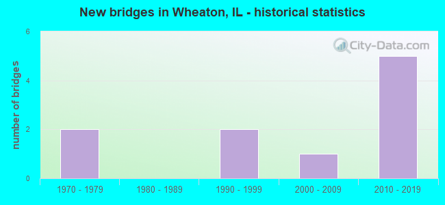
- New bridges - historical statistics
- 21970-1979
- 21990-1999
- 12000-2009
- 52010-2019


- Bridge Condition - Deck
- 25.0%Good
- 25.0%Satisfactory
- 25.0%Fair
- 25.0%Poor

- Bridge Condition - Superstructure
- 50.0%Good
- 25.0%Fair
- 25.0%Poor

- Bridge Condition - Substructure
- 50.0%Very good
- 50.0%Serious

- Bridge Condition - Channel
- 16.7%Very good
- 16.7%Good
- 50.0%Satisfactory
- 16.7%Fair

- Bridge Condition - Culverts
- 33.3%Very good
- 66.7%Good
Find on map >> Show street view
Structure Number: 220166, Location: 2 M W OF IL 53 (Lat: 41.829136, Lng: -88.094928), Route carried "on" structure: State highway 56, Year Built: 1990, Status: Open, Structure Length: 0.82m (2.69ft), Average Daily Traffic: 24,700 (year 2021), Truck Traffic: 2%, Average Future Daily Traffic: 40,884 (year 2032), Features Intersected: WILLOWAY BROOK
Minimum Vertical Clearance: 30+ m (98+ ft), Kilometerpoint: 32.814, Lanes on structure: 4, Base Highway Network: Yes, Owner: State Highway Agency, Approaching Roadway Width: 20.7m (67.9ft), Skew: 2 degrees, Material/Design: Concrete continuous, Design/Construction: Culvert, Number Of Spans In Main Unit: 3, Length of Maximum Span: 2.7m (8.9ft)
Condition: Channel: Very good, Culverts: Good, Operating Rating: 44.1 metric tons, Method Used To Determine Operating Rating: Load Factor (LF) rating reported by rating factor (RF) method using MS18 loading, Inventory Rating: 32.4 metric tons, Method Used To Determine Inventory Rating: Load Factor (LF) rating reported by rating factor (RF) method using MS18 loading, Structural Evaluation: Better than present minimum criteria, Waterway Adequacy: Better than present minimum criteria, Approach Roadway Alignment: Equal to present desirable criteria, Designated Inspection Frequency: Every 48 months, Inspection Date: April 2019
Find on map >> Show street view
Structure Number: 220169, Location: .83 MI SO OF GENEVA (Lat: 41.876475, Lng: -88.118175), Route carried "on" structure: Other road , Year Built: 1999, Status: Open, Structure Length: 0.91m (2.99ft), Average Daily Traffic: 10,200 (year 2020), Truck Traffic: 9%, Average Future Daily Traffic: 30,635 (year 2032), Design Load: HS 20, Features Intersected: WINFIELD CREEK, Facility Carried by Structure: GARY AV
Minimum Vertical Clearance: 30+ m (98+ ft), Kilometerpoint: 12.697, Lanes on structure: 2, Owner: City or Municipal Highway Agency, Approaching Roadway Width: 11.9m (39.0ft), Material/Design: Concrete continuous, Design/Construction: Culvert, Number Of Spans In Main Unit: 3, Length of Maximum Span: 3.0m (9.8ft), Curb-To-Curb Width: 11.9m (39.0ft), Out-to-Out Width: 14.1m (46.3ft)
Condition: Channel: Good, Culverts: Good, Operating Rating: 56.7 metric tons, Method Used To Determine Operating Rating: Load Factor (LF) rating reported by rating factor (RF) method using MS18 loading, Inventory Rating: 34.0 metric tons, Method Used To Determine Inventory Rating: Load Factor (LF) rating reported by rating factor (RF) method using MS18 loading, Structural Evaluation: Better than present minimum criteria, Deck Geometry: Somewhat better than minimum adequacy, Waterway Adequacy: Superior to present desirable criteria, Approach Roadway Alignment: Equal to present desirable criteria, Designated Inspection Frequency: Every 48 months, Inspection Date: May 2020
Find on map >> Show street view
Structure Number: 222028, Location: 400'E OF ORCHARD RD (Lat: 41.828761, Lng: -88.124272), Route carried "on" structure: State highway 56, Year Built: 2012, Year Reconstructed: 2016, Status: Open, Structure Length: 0.67m (2.20ft), Average Daily Traffic: 20,300 (year 2021), Truck Traffic: 7%, Average Future Daily Traffic: 37,500 (year 2041), Features Intersected: DRAINAGE DITCH
Minimum Vertical Clearance: 30+ m (98+ ft), Kilometerpoint: 30.351, Lanes on structure: 4, Base Highway Network: Yes, Owner: State Highway Agency, Approaching Roadway Width: 22.2m (72.8ft), Skew: 10 degrees, Material/Design: Concrete, Design/Construction: Culvert, Length of Maximum Span: 6.4m (21.0ft)
Condition: Channel: Satisfactory, Culverts: Very good, Operating Rating: 48.3 metric tons, Method Used To Determine Operating Rating: Load and Resistance Factor Rating (LRFR) rating reported by rating factor(RF) method using HL-93 loadings, Inventory Rating: 37.3 metric tons, Method Used To Determine Inventory Rating: Load and Resistance Factor Rating (LRFR) rating reported by rating factor(RF) method using HL-93 loadings, Structural Evaluation: Equal to present desirable criteria, Waterway Adequacy: Equal to present minimum criteria, Approach Roadway Alignment: Equal to present minimum criteria, Designated Inspection Frequency: Every 48 months, Inspection Date: October 2020
Find on map >> Show street view
Structure Number: 227199, Location: 500' S of Cole Av (Lat: 41.882733, Lng: -88.106794), Route carried "on" structure: Other road , Year Built: 2013, Status: Open, Structure Length: 0.82m (2.69ft), Average Daily Traffic: 6,450 (year 2020), Truck Traffic: 4%, Average Future Daily Traffic: 10,000 (year 2036), Design Load: HS 20, Features Intersected: WINFIELD CREEK, Facility Carried by Structure: MAIN STREET
Minimum Vertical Clearance: 30+ m (98+ ft), Kilometerpoint: 6.389, Lanes on structure: 2, Base Highway Network: Yes, Owner: City or Municipal Highway Agency, Approaching Roadway Width: 11.9m (39.0ft), Skew: 20 degrees, Material/Design: Concrete, Design/Construction: Slab, Number Of Spans In Main Unit: 1, Length of Maximum Span: 7.9m (25.9ft), Curb or Sidewalk Widths: Left: 5.3m (17.4ft), Right: 5.3m (17.4ft), Curb-To-Curb Width: 11.9m (39.0ft), Out-to-Out Width: 22.9m (75.1ft)
Condition: Deck: Good, Superstructure: Good, Substructure: Very good, Channel: Satisfactory, Operating Rating: 42.1 metric tons, Method Used To Determine Operating Rating: Assigned ratings based on Load and Resistance Factor Design (LRFD) reported by rating factor (RF) using HL93 loadings, Inventory Rating: 32.4 metric tons, Method Used To Determine Inventory Rating: Assigned ratings based on Load and Resistance Factor Design (LRFD) reported by rating factor (RF) using HL93 loadings, Structural Evaluation: Better than present minimum criteria, Deck Geometry: Somewhat better than minimum adequacy, Waterway Adequacy: Somewhat better than minimum adequacy, Approach Roadway Alignment: Equal to present desirable criteria, Designated Inspection Frequency: Every 48 months, Inspection Date: August 2020, Deck Structure Type: Concrete Cast-file-Place, Wearing Surface/Protective System: Deck Protection: Epoxy Coated Reinforcing
Find on map >> Show street view
Structure Number: 227201, Location: 500 FT S SPRNG GREEN (Lat: 41.849086, Lng: -88.136717), Route carried "on" structure: City street , Year Built: 1970, Status: Posted for load, Structure Length: 2.19m (7.19ft), Average Daily Traffic: 1,700 (year 2020), Truck Traffic: 4%, Average Future Daily Traffic: 233 (year 2032), Design Load: HS 20, Features Intersected: SPRING BROOK, Facility Carried by Structure: STONEBRIDGE TRAIL
Minimum Vertical Clearance: 30+ m (98+ ft), Kilometerpoint: 0.483, Lanes on structure: 2, Owner: City or Municipal Highway Agency, Approaching Roadway Width: 8.2m (26.9ft), Skew: 4 degrees, Material/Design: Concrete continuous, Design/Construction: Slab, Number Of Spans In Main Unit: 3, Length of Maximum Span: 7.9m (25.9ft), Curb or Sidewalk Widths: Left: 1.4m (4.6ft), Right: 1.4m (4.6ft), Curb-To-Curb Width: 8.5m (27.9ft), Out-to-Out Width: 12.0m (39.4ft)
Condition: Deck: Poor, Superstructure: Poor, Substructure: Serious, Channel: Satisfactory, Operating Rating: 46.7 metric tons, Method Used To Determine Operating Rating: Allowable Stress (AS) rating reported by rating factor (RF) method using MS18 loading, Inventory Rating: 10.0 metric tons, Method Used To Determine Inventory Rating: Allowable Stress (AS) rating reported by rating factor (RF) method using MS18 loading, Structural Evaluation: High priority of corrective action, Deck Geometry: Somewhat better than minimum adequacy, Waterway Adequacy: Better than present minimum criteria, Approach Roadway Alignment: Equal to present desirable criteria, Bridge Posting: Required (Relationship of Operating Rating to Maximum Legal Load: 30.0 - 39.9% below), Designated Inspection Frequency: Every 24 months, Inspection Date: August 2021, Deck Structure Type: Concrete Cast-file-Place, Wearing Surface/Protective System: Wearing Surface: Other
Find on map >> Show street view
Structure Number: 227202, Location: 500 FT S SPRNG GREEN (Lat: 41.852153, Lng: -88.131061), Route carried "on" structure: City street , Year Built: 1970, Status: Posted for load, Structure Length: 1.68m (5.51ft), Average Daily Traffic: 2,050 (year 2020), Truck Traffic: 4%, Average Future Daily Traffic: 233 (year 2032), Design Load: HS 20, Features Intersected: Spring Brook, Facility Carried by Structure: MS-4065 Creekside
Minimum Vertical Clearance: 30+ m (98+ ft), Kilometerpoint: 0.579, Lanes on structure: 2, Owner: City or Municipal Highway Agency, Approaching Roadway Width: 8.2m (26.9ft), Material/Design: Concrete continuous, Design/Construction: Slab, Number Of Spans In Main Unit: 2, Length of Maximum Span: 7.6m (24.9ft), Curb or Sidewalk Widths: Left: 1.4m (4.6ft), Right: 1.4m (4.6ft), Curb-To-Curb Width: 8.5m (27.9ft), Out-to-Out Width: 12.0m (39.4ft)
Condition: Deck: Fair, Superstructure: Fair, Substructure: Serious, Channel: Fair, Operating Rating: 31.4 metric tons, Method Used To Determine Operating Rating: Allowable Stress (AS) rating reported by rating factor (RF) method using MS18 loading, Inventory Rating: 12.3 metric tons, Method Used To Determine Inventory Rating: Allowable Stress (AS) rating reported by rating factor (RF) method using MS18 loading, Structural Evaluation: High priority of corrective action, Deck Geometry: Meets minimum limits, Waterway Adequacy: Superior to present desirable criteria, Approach Roadway Alignment: Equal to present desirable criteria, Bridge Posting: Required (Relationship of Operating Rating to Maximum Legal Load: > 39.9% below), Designated Inspection Frequency: Every 24 months, Other Special Inspection Frequency: Every 12 months, Inspection Date: August 2021, Other Special Inspection Date: August 2021, Deck Structure Type: Concrete Cast-file-Place, Wearing Surface/Protective System: Wearing Surface: Other
Find on map >> Show street view
Structure Number: 227204, Location: 100' N MANCHESTER (Lat: 41.865889, Lng: -88.117739), Route carried "on" structure: Other road , Year Built: 2010, Status: Open, Structure Length: 2.90m (9.51ft), Average Daily Traffic: 1,000 (year 2020), Truck Traffic: 10%, Average Future Daily Traffic: 4,066 (year 2032), Design Load: HS 20, Features Intersected: UPRR / WEST, Facility Carried by Structure: WESLEY ST
Minimum Vertical Clearance: 30+ m (98+ ft), Kilometerpoint: 1.336, Lanes on structure: 3, Owner: City or Municipal Highway Agency, Approaching Roadway Width: 15.1m (49.5ft), Skew: 3 degrees, Material/Design: Steel, Design/Construction: Stringer/Multi-beam, Number Of Spans In Main Unit: 1, Length of Maximum Span: 28.2m (92.5ft), Curb or Sidewalk Widths: Left: 0.0m, Right: 2.0m (6.6ft), Curb-To-Curb Width: 15.1m (49.5ft), Out-to-Out Width: 18.6m (61.0ft)
Condition: Deck: Satisfactory, Superstructure: Good, Substructure: Very good, Operating Rating: 61.6 metric tons, Method Used To Determine Operating Rating: Load Factor (LF) rating reported by rating factor (RF) method using MS18 loading, Inventory Rating: 36.9 metric tons, Method Used To Determine Inventory Rating: Load Factor (LF) rating reported by rating factor (RF) method using MS18 loading, Structural Evaluation: Better than present minimum criteria, Deck Geometry: Equal to present minimum criteria, Underclear: Superior to present desirable criteria, Approach Roadway Alignment: Equal to present minimum criteria, Designated Inspection Frequency: Every 48 months, Critical Feature Inspection Frequency: Every 24 months, Inspection Date: May 2021, Critical Feature Inspection Date: May 2021, Deck Structure Type: Concrete Cast-file-Place, Wearing Surface/Protective System: Wearing Surface: Other, Deck Protection: Epoxy Coated Reinforcing
Find on map >> Show street view
Structure Number: 223005, Location: 0.46 MI N of IL RT38 (Lat: 41.865956, Lng: -88.116825), Route carried "under" structure: Other road , Year Built: 2010, Structure Length: 0. m, Average Daily Traffic: 1,000 (year 2020), Truck Traffic: 10%, Features Intersected: UPRR, WESLEY ST, FRO, Facility Carried by Structure: IL PRAIRIE PATH
Minimum Vertical Clearance: 4.42m (14.50ft), Kilometerpoint: 1.255, Lanes under structure: 2, Material/Design: Steel, Design/Construction: Truss - Thru, Length of Maximum Span: 48.5m (159.1ft)
Find on map >> Show street view
Structure Number: 223005, Location: 0.46 MI N of IL RT38 (Lat: 41.865558, Lng: -88.116664), Route carried "under" structure: Other road , Year Built: 2010, Structure Length: 0. m, Average Daily Traffic: 1,350 (year 2020), Truck Traffic: 8%, Features Intersected: UPRR, WESLEY ST, FRO, Facility Carried by Structure: IL PRAIRIE PATH
Minimum Vertical Clearance: 4.42m (14.50ft), Kilometerpoint: 0.080, Lanes under structure: 1, Material/Design: Steel, Design/Construction: Truss - Thru, Length of Maximum Span: 48.5m (159.1ft)
Find on map >> Show street view
Structure Number: 223109, Location: 0.8 MI N ILL 38 (Lat: 41.869964, Lng: -88.144594), Route carried "under" structure: Other road , Year Built: 2002, Structure Length: 0. m, Average Daily Traffic: 15,300 (year 2020), Truck Traffic: 7%, Features Intersected: COUNTY FARM ROAD, Facility Carried by Structure: UNION PACIFIC RR
Minimum Vertical Clearance: 5.16m (16.93ft), Kilometerpoint: 13.245, Lanes under structure: 4, Material/Design: Steel, Design/Construction: Stringer/Multi-beam, Length of Maximum Span: 25.3m (83.0ft)