Bridge Statistics for Westminster, Maryland (MD)
Condition, Traffic, Stress, Structural Evaluation, Project Costs
- National Bridge Inventory (NBI) Statistics
- 44Number of bridges
- 253ft / 76.8mTotal length
- $1,137,000Total costs
- 386,702Total average daily traffic
- 26,872Total average daily truck traffic
- National Bridge Inventory (NBI) Registered Bridges for Westminster
- No street view available for this location
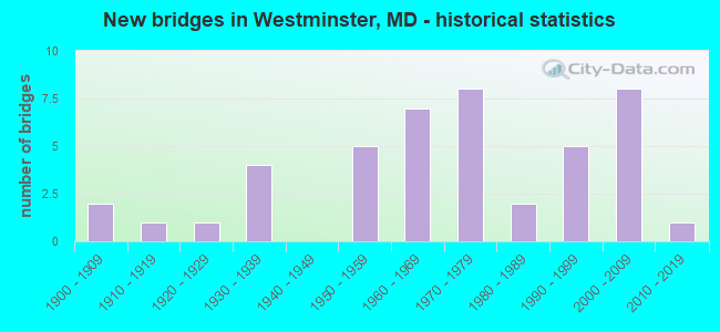
- New bridges - historical statistics
- 21900-1909
- 11910-1919
- 11920-1929
- 41930-1939
- 51950-1959
- 71960-1969
- 81970-1979
- 21980-1989
- 51990-1999
- 82000-2009
- 12010-2019

- Reconstructed bridges - Historical Statistics
- 11960-1969
- 21970-1979
- 11980-1989
- 01990-1999
- 12000-2009


- Bridge Condition - Deck
- 3.8%Very good
- 42.3%Good
- 30.8%Satisfactory
- 23.1%Fair

- Bridge Condition - Superstructure
- 15.4%Very good
- 34.6%Good
- 30.8%Satisfactory
- 15.4%Fair
- 3.8%Poor

- Bridge Condition - Substructure
- 7.7%Very good
- 38.5%Good
- 42.3%Satisfactory
- 11.5%Fair

- Bridge Condition - Channel
- 2.9%Very good
- 23.5%Good
- 64.7%Satisfactory
- 8.8%Fair

- Bridge Condition - Culverts
- 28.6%Good
- 64.3%Satisfactory
- 7.1%Fair
Find on map >> Show street view
Structure Number: 10000006000301, Location: 0.4 MILE NORTH OF MD 808B (Lat: 39.558928, Lng: -77.006986), Route carried "on" structure: State highway 27, Year Built: 1991, Status: Open, Structure Length: 3.60m (11.81ft), Average Daily Traffic: 10,690 (year 2018), Truck Traffic: 11%, Average Future Daily Traffic: 10,728 (year 2038), Design Load: HS 20, Features Intersected: MARYLAND MIDLAND RR
Minimum Vertical Clearance: 30+ m (98+ ft), Kilometerpoint: 27.691, Lanes on structure: 2, Base Highway Network: Yes, Owner: State Highway Agency, Approaching Roadway Width: 11.6m (38.1ft), Skew: 3 degrees, Material/Design: Steel, Design/Construction: Stringer/Multi-beam, Number Of Spans In Main Unit: 1, Length of Maximum Span: 33.5m (109.9ft), Curb-To-Curb Width: 11.6m (38.1ft), Out-to-Out Width: 12.6m (41.3ft)
Condition: Deck: Good, Superstructure: Good, Substructure: Good, Inventory Rating: 57.1 metric tons, Method Used To Determine Inventory Rating: Load Factor (LF), Structural Evaluation: Better than present minimum criteria, Deck Geometry: Somewhat better than minimum adequacy, Underclear: Meets minimum limits, Approach Roadway Alignment: Equal to present desirable criteria, Designated Inspection Frequency: Every 24 months, Inspection Date: June 2021, Deck Structure Type: Concrete Cast-file-Place, Wearing Surface/Protective System: Wearing Surface: Integral Concrete, Deck Protection: Epoxy Coated Reinforcing
Find on map >> Show street view
Structure Number: 10000006000403, Location: .12 MILE NORTH OF MD 852H (Lat: 39.583558, Lng: -76.970744), Route carried "on" structure: State highway 852G, Year Built: 1985, Status: Open, Structure Length: 1.35m (4.43ft), Average Daily Traffic: 1,150 (year 2009), Truck Traffic: 8%, Average Future Daily Traffic: 234 (year 2026), Design Load: HS 20, Features Intersected: CRANBERRY BRANCH
Minimum Vertical Clearance: 30+ m (98+ ft), Kilometerpoint: 0.547, Lanes on structure: 2, Owner: State Highway Agency, Approaching Roadway Width: 9.8m (32.2ft), Skew: 4 degrees, Material/Design: Steel, Design/Construction: Culvert, Length of Maximum Span: 3.7m (12.1ft)
Condition: Channel: Satisfactory, Culverts: Satisfactory, Structural Evaluation: Equal to present minimum criteria, Waterway Adequacy: Equal to present minimum criteria, Approach Roadway Alignment: Equal to present desirable criteria, Designated Inspection Frequency: Every 24 months, Inspection Date: March 2021
Find on map >> Show street view
Structure Number: 10000006000501, Location: 0.02 MILE WEST OF MD 852G (Lat: 39.584078, Lng: -76.973192), Route carried "on" structure: ServiceState highway 852H, Year Built: 1911, Status: Open, Structure Length: 0.67m (2.20ft), Average Daily Traffic: 999 (year 2002), Truck Traffic: 8%, Average Future Daily Traffic: 1,152 (year 2022), Features Intersected: WEST BRANCH PATAPSCO RIV
Minimum Vertical Clearance: 30+ m (98+ ft), Kilometerpoint: 0.354, Lanes on structure: 2, Owner: State Highway Agency, Approaching Roadway Width: 7.9m (25.9ft), Skew: 2 degrees, Material/Design: Concrete, Design/Construction: Tee Beam, Number Of Spans In Main Unit: 1, Length of Maximum Span: 6.1m (20.0ft), Curb-To-Curb Width: 6.7m (22.0ft), Out-to-Out Width: 7.3m (24.0ft)
Condition: Deck: Fair, Superstructure: Fair, Substructure: Fair, Channel: Satisfactory, Inventory Rating: 54.9 metric tons, Method Used To Determine Inventory Rating: Load Factor (LF), Structural Evaluation: Somewhat better than minimum adequacy, Deck Geometry: Meets minimum limits, Waterway Adequacy: Equal to present minimum criteria, Approach Roadway Alignment: Equal to present minimum criteria, Length Of Structure Improvement: 0.67m (2.20ft), Designated Inspection Frequency: Every 24 months, Inspection Date: May 2020, Bridge Improvement Cost: $32,000, Roadway Improvement Cost: $3,000, Total Project Cost: $35,000, Deck Structure Type: Concrete Cast-file-Place, Wearing Surface/Protective System: Wearing Surface: Bituminous
Find on map >> Show street view
Structure Number: 10000006000601, Location: 0.04 M W OF ADAMS MILL RD (Lat: 39.561550, Lng: -77.044325), Route carried "on" structure: State highway 852, Year Built: 1900, Status: Open, Structure Length: 1.77m (5.81ft), Average Daily Traffic: 400 (year 2009), Truck Traffic: 8%, Average Future Daily Traffic: 706 (year 2026), Features Intersected: LITTLE PIPE CREEK
Minimum Vertical Clearance: 30+ m (98+ ft), Kilometerpoint: 5.110, Lanes on structure: 2, Owner: State Highway Agency, Approaching Roadway Width: 6.7m (22.0ft), Skew: 4 degrees, Material/Design: Concrete, Design/Construction: Tee Beam, Number Of Spans In Main Unit: 2, Length of Maximum Span: 7.6m (24.9ft), Curb-To-Curb Width: 6.9m (22.6ft), Out-to-Out Width: 8.0m (26.2ft)
Condition: Deck: Fair, Superstructure: Fair, Substructure: Fair, Channel: Satisfactory, Operating Rating: 57.1 metric tons, Method Used To Determine Operating Rating: Load Factor (LF), Inventory Rating: 34.0 metric tons, Method Used To Determine Inventory Rating: Load Factor (LF), Structural Evaluation: Somewhat better than minimum adequacy, Deck Geometry: Meets minimum limits, Waterway Adequacy: Better than present minimum criteria, Approach Roadway Alignment: Equal to present desirable criteria, Length Of Structure Improvement: 1.77m (5.81ft), Designated Inspection Frequency: Every 24 months, Inspection Date: May 2021, Bridge Improvement Cost: $91,000, Roadway Improvement Cost: $9,000, Total Project Cost: $100,000, Deck Structure Type: Concrete Cast-file-Place, Wearing Surface/Protective System: Wearing Surface: Bituminous
Find on map >> Show street view
Structure Number: 10000006002702, Location: 0.17 MILE SOUTH OF MD 832 (Lat: 39.590464, Lng: -77.031678), Route carried "on" structure: State highway 140, Year Built: 1952, Status: Open, Structure Length: 0.89m (2.92ft), Average Daily Traffic: 17,390 (year 2009), Truck Traffic: 8%, Average Future Daily Traffic: 21,950 (year 2029), Design Load: H 20, Features Intersected: MEADOW BRANCH
Minimum Vertical Clearance: 30+ m (98+ ft), Kilometerpoint: 19.582, Lanes on structure: 2, Base Highway Network: Yes, Owner: State Highway Agency, Approaching Roadway Width: 13.4m (44.0ft), Skew: 5 degrees, Material/Design: Concrete, Design/Construction: Culvert, Length of Maximum Span: 8.8m (28.9ft)
Condition: Channel: Satisfactory, Culverts: Satisfactory, Operating Rating: 89.8 metric tons, Method Used To Determine Operating Rating: Load Factor (LF), Inventory Rating: 60.8 metric tons, Method Used To Determine Inventory Rating: Load Factor (LF), Structural Evaluation: Equal to present minimum criteria, Waterway Adequacy: Equal to present desirable criteria, Approach Roadway Alignment: Equal to present desirable criteria, Designated Inspection Frequency: Every 24 months, Inspection Date: October 2020
Find on map >> Show street view
Structure Number: 10000006003104, Location: 3.35 MILE NORTH OF MD 496 (Lat: 39.667161, Lng: -77.019775), Route carried "on" structure: State highway 97, Year Built: 1934, Status: Open, Structure Length: 2.40m (7.87ft), Average Daily Traffic: 15,340 (year 2009), Truck Traffic: 8%, Average Future Daily Traffic: 17,872 (year 2026), Design Load: H 20, Features Intersected: BIG PIPE CREEK
Minimum Vertical Clearance: 30+ m (98+ ft), Kilometerpoint: 38.101, Lanes on structure: 2, Base Highway Network: Yes, Owner: State Highway Agency, Approaching Roadway Width: 9.8m (32.2ft), Material/Design: Concrete continuous, Design/Construction: Frame, Number Of Spans In Main Unit: 2, Length of Maximum Span: 10.7m (35.1ft), Curb-To-Curb Width: 9.1m (29.9ft), Out-to-Out Width: 10.3m (33.8ft)
Condition: Deck: Satisfactory, Superstructure: Satisfactory, Substructure: Satisfactory, Channel: Satisfactory, Operating Rating: 37.2 metric tons, Method Used To Determine Operating Rating: Load Factor (LF), Inventory Rating: 22.2 metric tons, Method Used To Determine Inventory Rating: Load Factor (LF), Structural Evaluation: Somewhat better than minimum adequacy, Deck Geometry: High priority of corrective action, Waterway Adequacy: Superior to present desirable criteria, Approach Roadway Alignment: Equal to present minimum criteria, Designated Inspection Frequency: Every 24 months, Inspection Date: October 2020, Deck Structure Type: Concrete Cast-file-Place, Wearing Surface/Protective System: Wearing Surface: Monolithic Concrete
Find on map >> Show street view
Structure Number: 10000006003201, Location: 0.02 MILE NORTH OF MD 27 (Lat: 39.581200, Lng: -76.987772), Route carried "on" structure: State highway 140, Year Built: 2006, Status: Open, Structure Length: 9.30m (30.51ft), Average Daily Traffic: 45,521 (year 2006), Truck Traffic: 8%, Average Future Daily Traffic: 52,486 (year 2026), Design Load: HS 25 or greater, Features Intersected: MD MID RR, MD27, WEST BR
Minimum Vertical Clearance: 30+ m (98+ ft), Kilometerpoint: 15.092, Lanes on structure: 8, Lanes under structure: 2, Base Highway Network: Yes, Owner: State Highway Agency, Approaching Roadway Width: 35.7m (117.1ft), Skew: 30 degrees, Material/Design: Steel continuous, Design/Construction: Stringer/Multi-beam, Number Of Spans In Main Unit: 2, Length of Maximum Span: 46.3m (151.9ft), Curb or Sidewalk Widths: Left: 1.6m (5.2ft), Right: 1.6m (5.2ft), Curb-To-Curb Width: 33.8m (110.9ft), Out-to-Out Width: 39.6m (129.9ft)
Condition: Deck: Good, Superstructure: Very good, Substructure: Very good, Channel: Good, Inventory Rating: 58.5 metric tons, Method Used To Determine Inventory Rating: Load Factor (LF), Structural Evaluation: Equal to present desirable criteria, Deck Geometry: Equal to present minimum criteria, Underclear: Equal to present minimum criteria, Waterway Adequacy: Equal to present desirable criteria, Approach Roadway Alignment: Equal to present desirable criteria, Designated Inspection Frequency: Every 24 months, Inspection Date: September 2020, Deck Structure Type: Concrete Cast-file-Place, Wearing Surface/Protective System: Wearing Surface: Monolithic Concrete, Deck Protection: Epoxy Coated Reinforcing
Find on map >> Show street view
Structure Number: 10000006003901, Location: 3.03 MI E OF MD 97 (Lat: 39.654647, Lng: -76.957472), Route carried "on" structure: State highway 496, Year Built: 1931, Status: Open, Structure Length: 0.67m (2.20ft), Average Daily Traffic: 4,042 (year 2009), Truck Traffic: 8%, Average Future Daily Traffic: 5,242 (year 2029), Features Intersected: BR OF BIG PIPE CREEK
Minimum Vertical Clearance: 30+ m (98+ ft), Kilometerpoint: 4.858, Lanes on structure: 2, Owner: State Highway Agency, Approaching Roadway Width: 6.7m (22.0ft), Material/Design: Concrete, Design/Construction: Slab, Number Of Spans In Main Unit: 1, Length of Maximum Span: 6.1m (20.0ft), Curb-To-Curb Width: 8.2m (26.9ft), Out-to-Out Width: 9.4m (30.8ft)
Condition: Deck: Fair, Superstructure: Fair, Substructure: Satisfactory, Channel: Satisfactory, Operating Rating: 66.2 metric tons, Method Used To Determine Operating Rating: Load Factor (LF), Inventory Rating: 39.5 metric tons, Method Used To Determine Inventory Rating: Load Factor (LF), Structural Evaluation: Somewhat better than minimum adequacy, Deck Geometry: High priority of corrective action, Waterway Adequacy: Equal to present minimum criteria, Approach Roadway Alignment: Equal to present desirable criteria, Length Of Structure Improvement: 0.67m (2.20ft), Designated Inspection Frequency: Every 24 months, Inspection Date: March 2020, Bridge Improvement Cost: $41,000, Roadway Improvement Cost: $4,000, Total Project Cost: $45,000, Deck Structure Type: Concrete Cast-file-Place, Wearing Surface/Protective System: Wearing Surface: Monolithic Concrete
Find on map >> Show street view
Structure Number: 10000006004001, Location: 0.76 MILE EAST OF MD 97 (Lat: 39.633731, Lng: -76.988964), Route carried "on" structure: State highway 496, Year Built: 1931, Status: Open, Structure Length: 0.61m (2.00ft), Average Daily Traffic: 4,042 (year 2009), Truck Traffic: 8%, Average Future Daily Traffic: 5,242 (year 2029), Features Intersected: BEAR BRANCH
Minimum Vertical Clearance: 30+ m (98+ ft), Kilometerpoint: 1.231, Lanes on structure: 2, Owner: State Highway Agency, Approaching Roadway Width: 6.1m (20.0ft), Skew: 1 degrees, Material/Design: Concrete, Design/Construction: Slab, Number Of Spans In Main Unit: 1, Length of Maximum Span: 6.1m (20.0ft), Curb-To-Curb Width: 8.3m (27.2ft), Out-to-Out Width: 9.4m (30.8ft)
Condition: Deck: Satisfactory, Superstructure: Satisfactory, Substructure: Satisfactory, Channel: Satisfactory, Operating Rating: 74.8 metric tons, Method Used To Determine Operating Rating: Load Factor (LF), Inventory Rating: 44.9 metric tons, Method Used To Determine Inventory Rating: Load Factor (LF), Structural Evaluation: Equal to present minimum criteria, Deck Geometry: High priority of corrective action, Waterway Adequacy: Superior to present desirable criteria, Approach Roadway Alignment: Equal to present desirable criteria, Length Of Structure Improvement: 0.61m (2.00ft), Designated Inspection Frequency: Every 24 months, Inspection Date: March 2020, Bridge Improvement Cost: $37,000, Roadway Improvement Cost: $4,000, Total Project Cost: $41,000, Deck Structure Type: Concrete Cast-file-Place, Wearing Surface/Protective System: Wearing Surface: Monolithic Concrete
Find on map >> Show street view
Structure Number: 100000060041011, Location: 0.35 MILE SOUTH OF MD 31 (Lat: 39.590942, Lng: -76.998972), Route carried "on" structure: State highway 140, Year Built: 2006, Status: Open, Structure Length: 3.72m (12.20ft), Average Daily Traffic: 47,060 (year 2009), Truck Traffic: 10%, Average Future Daily Traffic: 26,243 (year 2026), Design Load: HS 25 or greater, Features Intersected: MD 97
Minimum Vertical Clearance: 30+ m (98+ ft), Kilometerpoint: 16.566, Lanes on structure: 3, Lanes under structure: 2, Base Highway Network: Yes, Owner: State Highway Agency, Approaching Roadway Width: 12.8m (42.0ft), Skew: 1 degrees, Material/Design: Steel continuous, Design/Construction: Stringer/Multi-beam, Number Of Spans In Main Unit: 1, Length of Maximum Span: 36.6m (120.1ft), Curb or Sidewalk Widths: Left: 0.0m, Right: 1.6m (5.2ft), Curb-To-Curb Width: 14.5m (47.6ft), Out-to-Out Width: 17.1m (56.1ft)
Condition: Deck: Good, Superstructure: Very good, Substructure: Good, Operating Rating: 86.6 metric tons, Method Used To Determine Operating Rating: Load Factor (LF), Inventory Rating: 51.7 metric tons, Method Used To Determine Inventory Rating: Load Factor (LF), Structural Evaluation: Better than present minimum criteria, Deck Geometry: Somewhat better than minimum adequacy, Underclear: Equal to present minimum criteria, Approach Roadway Alignment: Equal to present desirable criteria, Designated Inspection Frequency: Every 24 months, Inspection Date: August 2021, Deck Structure Type: Concrete Cast-file-Place, Wearing Surface/Protective System: Wearing Surface: Monolithic Concrete, Deck Protection: Epoxy Coated Reinforcing
Find on map >> Show street view
Structure Number: 100000060041012, Location: 0.35 MILE SOUTH OF MD 31 (Lat: 39.590806, Lng: -76.999375), Route carried "on" structure: State highway 140, Year Built: 2006, Status: Open, Structure Length: 3.72m (12.20ft), Average Daily Traffic: 47,060 (year 2009), Truck Traffic: 10%, Average Future Daily Traffic: 26,243 (year 2026), Design Load: HS 25 or greater, Features Intersected: MD 97
Minimum Vertical Clearance: 30+ m (98+ ft), Kilometerpoint: 16.566, Lanes on structure: 3, Lanes under structure: 2, Base Highway Network: Yes, Owner: State Highway Agency, Approaching Roadway Width: 12.8m (42.0ft), Skew: 1 degrees, Material/Design: Steel continuous, Design/Construction: Stringer/Multi-beam, Number Of Spans In Main Unit: 1, Length of Maximum Span: 36.6m (120.1ft), Curb or Sidewalk Widths: Left: 0.0m, Right: 1.6m (5.2ft), Curb-To-Curb Width: 14.5m (47.6ft), Out-to-Out Width: 17.1m (56.1ft)
Condition: Deck: Good, Superstructure: Very good, Substructure: Good, Operating Rating: 85.3 metric tons, Method Used To Determine Operating Rating: Load Factor (LF), Inventory Rating: 51.2 metric tons, Method Used To Determine Inventory Rating: Load Factor (LF), Structural Evaluation: Better than present minimum criteria, Deck Geometry: Somewhat better than minimum adequacy, Underclear: Equal to present minimum criteria, Approach Roadway Alignment: Equal to present desirable criteria, Designated Inspection Frequency: Every 24 months, Inspection Date: August 2021, Deck Structure Type: Concrete Cast-file-Place, Wearing Surface/Protective System: Wearing Surface: Monolithic Concrete, Deck Protection: Epoxy Coated Reinforcing
Find on map >> Show street view
Structure Number: 10000006004401, Location: 2.69 MILE NORTH OF MD 832 (Lat: 39.612244, Lng: -77.077039), Route carried "on" structure: State highway 140, Year Built: 1963, Year Reconstructed: 1979, Status: Open, Structure Length: 2.87m (9.42ft), Average Daily Traffic: 13,070 (year 2009), Truck Traffic: 8%, Average Future Daily Traffic: 14,471 (year 2026), Design Load: HS 20, Features Intersected: RICHARDSON RD
Minimum Vertical Clearance: 30+ m (98+ ft), Kilometerpoint: 24.183, Lanes on structure: 2, Lanes under structure: 2, Base Highway Network: Yes, Owner: State Highway Agency, Approaching Roadway Width: 13.4m (44.0ft), Material/Design: Steel, Design/Construction: Stringer/Multi-beam, Number Of Spans In Main Unit: 3, Length of Maximum Span: 12.5m (41.0ft), Curb-To-Curb Width: 11.3m (37.1ft), Out-to-Out Width: 12.4m (40.7ft)
Condition: Deck: Fair, Superstructure: Satisfactory, Substructure: Satisfactory, Inventory Rating: 56.7 metric tons, Method Used To Determine Inventory Rating: Load Factor (LF), Structural Evaluation: Equal to present minimum criteria, Deck Geometry: Meets minimum limits, Underclear: Meets minimum limits, Approach Roadway Alignment: Equal to present desirable criteria, Designated Inspection Frequency: Every 24 months, Inspection Date: August 2021, Deck Structure Type: Concrete Cast-file-Place, Wearing Surface/Protective System: Wearing Surface: Bituminous
Find on map >> Show street view
Structure Number: 10000006004602, Location: 0.02 MILE WEST OF MD 852 (Lat: 39.557828, Lng: -77.036661), Route carried "on" structure: State highway 31, Year Built: 1963, Status: Open, Structure Length: 0.91m (2.99ft), Average Daily Traffic: 7,321 (year 2009), Truck Traffic: 8%, Average Future Daily Traffic: 9,214 (year 2026), Design Load: HS 20, Features Intersected: LITTLE PIPE CREEK
Minimum Vertical Clearance: 30+ m (98+ ft), Kilometerpoint: 12.051, Lanes on structure: 3, Base Highway Network: Yes, Owner: State Highway Agency, Approaching Roadway Width: 13.4m (44.0ft), Skew: 1 degrees, Material/Design: Concrete, Design/Construction: Culvert, Length of Maximum Span: 4.3m (14.1ft)
Condition: Channel: Satisfactory, Culverts: Satisfactory, Operating Rating: 32.7 metric tons, Method Used To Determine Operating Rating: Field evaluation and documented engineering judgment, Inventory Rating: 32.7 metric tons, Method Used To Determine Inventory Rating: Field evaluation and documented engineering judgment, Structural Evaluation: Equal to present minimum criteria, Waterway Adequacy: Equal to present minimum criteria, Approach Roadway Alignment: Equal to present desirable criteria, Designated Inspection Frequency: Every 24 months, Inspection Date: Febuary 2021
Find on map >> Show street view
Structure Number: 10000006004804, Location: .12 MILE SOUTH OF MD 852G (Lat: 39.585375, Lng: -76.977222), Route carried "on" structure: State highway 27, Year Built: 1959, Status: Open, Structure Length: 1.83m (6.00ft), Average Daily Traffic: 18,790 (year 2018), Truck Traffic: 8%, Average Future Daily Traffic: 18,857 (year 2038), Design Load: HS 20, Features Intersected: MARYLAND MIDLAND RR
Minimum Vertical Clearance: 30+ m (98+ ft), Kilometerpoint: 31.794, Lanes on structure: 2, Base Highway Network: Yes, Owner: State Highway Agency, Approaching Roadway Width: 13.4m (44.0ft), Skew: 4 degrees, Material/Design: Concrete, Design/Construction: Frame, Number Of Spans In Main Unit: 1, Length of Maximum Span: 15.5m (50.9ft), Curb-To-Curb Width: 14.6m (47.9ft), Out-to-Out Width: 15.7m (51.5ft)
Condition: Deck: Satisfactory, Superstructure: Satisfactory, Substructure: Satisfactory, Operating Rating: 33.6 metric tons, Method Used To Determine Operating Rating: Load Factor (LF), Inventory Rating: 20.0 metric tons, Method Used To Determine Inventory Rating: Load Factor (LF), Structural Evaluation: Somewhat better than minimum adequacy, Deck Geometry: Superior to present desirable criteria, Underclear: Meets minimum limits, Approach Roadway Alignment: Equal to present desirable criteria, Designated Inspection Frequency: Every 24 months, Inspection Date: April 2020, Deck Structure Type: Concrete Cast-file-Place, Wearing Surface/Protective System: Wearing Surface: Bituminous
Find on map >> Show street view
Structure Number: 10000006005202, Location: .04 MILE SOUTH OF MD 852G (Lat: 39.586164, Lng: -76.976036), Route carried "on" structure: State highway 27, Year Built: 1959, Status: Open, Structure Length: 0.77m (2.53ft), Average Daily Traffic: 18,790 (year 2018), Truck Traffic: 8%, Average Future Daily Traffic: 18,790 (year 2038), Design Load: HS 20, Features Intersected: WEST BRANCH PATAPSCO RIV
Minimum Vertical Clearance: 30+ m (98+ ft), Kilometerpoint: 31.923, Lanes on structure: 2, Base Highway Network: Yes, Owner: State Highway Agency, Approaching Roadway Width: 13.4m (44.0ft), Material/Design: Concrete, Design/Construction: Culvert, Length of Maximum Span: 3.7m (12.1ft)
Condition: Channel: Satisfactory, Culverts: Satisfactory, Operating Rating: 32.7 metric tons, Method Used To Determine Operating Rating: Field evaluation and documented engineering judgment, Inventory Rating: 32.7 metric tons, Method Used To Determine Inventory Rating: Field evaluation and documented engineering judgment, Structural Evaluation: Equal to present minimum criteria, Waterway Adequacy: Equal to present desirable criteria, Approach Roadway Alignment: Equal to present desirable criteria, Designated Inspection Frequency: Every 24 months, Inspection Date: April 2021
Find on map >> Show street view
Structure Number: 10000006005302, Location: .52 MILE NORTH OF MD 852G (Lat: 39.591144, Lng: -76.968222), Route carried "on" structure: State highway 27, Year Built: 1959, Status: Open, Structure Length: 0.97m (3.18ft), Average Daily Traffic: 18,790 (year 2018), Truck Traffic: 8%, Average Future Daily Traffic: 18,857 (year 2038), Design Load: HS 20, Features Intersected: CRANBERRY BRANCH
Minimum Vertical Clearance: 30+ m (98+ ft), Kilometerpoint: 32.824, Lanes on structure: 3, Base Highway Network: Yes, Owner: State Highway Agency, Approaching Roadway Width: 15.2m (49.9ft), Skew: 2 degrees, Material/Design: Concrete, Design/Construction: Culvert, Length of Maximum Span: 4.9m (16.1ft)
Condition: Channel: Satisfactory, Culverts: Satisfactory, Operating Rating: 32.7 metric tons, Method Used To Determine Operating Rating: Field evaluation and documented engineering judgment, Inventory Rating: 32.7 metric tons, Method Used To Determine Inventory Rating: Field evaluation and documented engineering judgment, Structural Evaluation: Equal to present minimum criteria, Waterway Adequacy: Better than present minimum criteria, Approach Roadway Alignment: Equal to present desirable criteria, Designated Inspection Frequency: Every 24 months, Inspection Date: March 2021
Find on map >> Show street view
Structure Number: 10000006006703, Location: 0.4 MILE NORTH OF MD 808B (Lat: 39.558911, Lng: -77.007075), Route carried "on" structure: State highway 27, Year Built: 1991, Status: Open, Structure Length: 0.62m (2.03ft), Average Daily Traffic: 10,690 (year 2018), Truck Traffic: 8%, Average Future Daily Traffic: 10,728 (year 2038), Design Load: HS 20, Features Intersected: LITTLE PIPE CREEK
Minimum Vertical Clearance: 30+ m (98+ ft), Kilometerpoint: 27.755, Lanes on structure: 2, Base Highway Network: Yes, Owner: State Highway Agency, Approaching Roadway Width: 11.6m (38.1ft), Skew: 1 degrees, Material/Design: Steel, Design/Construction: Culvert, Length of Maximum Span: 2.7m (8.9ft)
Condition: Channel: Good, Culverts: Fair, Structural Evaluation: Somewhat better than minimum adequacy, Waterway Adequacy: Equal to present desirable criteria, Approach Roadway Alignment: Equal to present desirable criteria, Designated Inspection Frequency: Every 24 months, Inspection Date: August 2020
Find on map >> Show street view
Structure Number: 200000CL025601, Location: 0.01 MI S OF JASONTOWN RD (Lat: 39.567703, Lng: -77.066308), Route carried "on" structure: County highway 262, Year Built: 1900, Year Reconstructed: 1974, Status: Open, Structure Length: 1.11m (3.64ft), Average Daily Traffic: 320 (year 2021), Truck Traffic: 5%, Average Future Daily Traffic: 530 (year 2041), Design Load: H 20, Features Intersected: LITTLE PIPE CREEK, Facility Carried by Structure: JOHN HYDE ROAD
Minimum Vertical Clearance: 30+ m (98+ ft), Kilometerpoint: 1.689, Lanes on structure: 2, Base Highway Network: Yes, Owner: County Highway Agency, Approaching Roadway Width: 5.5m (18.0ft), Material/Design: Prestressed concrete, Design/Construction: Box Beam or Girders - Multiple, Number Of Spans In Main Unit: 1, Length of Maximum Span: 9.8m (32.2ft), Curb-To-Curb Width: 5.4m (17.7ft), Out-to-Out Width: 5.5m (18.0ft)
Condition: Deck: Fair, Superstructure: Fair, Substructure: Fair, Channel: Satisfactory, Operating Rating: 54.0 metric tons, Method Used To Determine Operating Rating: Load Factor (LF), Inventory Rating: 32.2 metric tons, Method Used To Determine Inventory Rating: Load Factor (LF), Structural Evaluation: Somewhat better than minimum adequacy, Deck Geometry: High priority of replacement, Waterway Adequacy: Better than present minimum criteria, Approach Roadway Alignment: High priority of corrective action, Length Of Structure Improvement: 4.27m (14.01ft), Designated Inspection Frequency: Every 12 months, Inspection Date: May 2021, Bridge Improvement Cost: $170,000, Roadway Improvement Cost: $20,000, Total Project Cost: $190,000, Deck Structure Type: Concrete Cast-file-Place, Wearing Surface/Protective System: Wearing Surface: Bituminous
Find on map >> Show street view
Structure Number: 200000CL025701, Location: 0.01 MI N OF ROOPS MIL RD (Lat: 39.567583, Lng: -77.059744), Route carried "on" structure: County highway 258, Year Built: 1997, Status: Open, Structure Length: 1.32m (4.33ft), Average Daily Traffic: 89 (year 2021), Truck Traffic: 5%, Average Future Daily Traffic: 150 (year 2041), Design Load: HS 25 or greater, Features Intersected: LITTLE PIPE CREEK, Facility Carried by Structure: ROCKLAND ROAD
Minimum Vertical Clearance: 30+ m (98+ ft), Kilometerpoint: 0.016, Lanes on structure: 2, Base Highway Network: Yes, Owner: County Highway Agency, Approaching Roadway Width: 7.3m (24.0ft), Material/Design: Steel, Design/Construction: Stringer/Multi-beam, Number Of Spans In Main Unit: 1, Length of Maximum Span: 12.2m (40.0ft), Curb-To-Curb Width: 7.3m (24.0ft), Out-to-Out Width: 8.0m (26.2ft)
Condition: Deck: Good, Superstructure: Good, Substructure: Good, Channel: Satisfactory, Inventory Rating: 74.4 metric tons, Method Used To Determine Inventory Rating: Load Factor (LF), Structural Evaluation: Better than present minimum criteria, Deck Geometry: Equal to present minimum criteria, Waterway Adequacy: Better than present minimum criteria, Approach Roadway Alignment: Equal to present minimum criteria, Designated Inspection Frequency: Every 24 months, Inspection Date: May 2021, Deck Structure Type: Concrete Cast-file-Place, Wearing Surface/Protective System: Wearing Surface: Monolithic Concrete, Deck Protection: Epoxy Coated Reinforcing
Find on map >> Show street view
Structure Number: 200000CL025902, Location: 1.07 MILES S OF MD 832 (Lat: 39.599872, Lng: -77.081922), Route carried "on" structure: County highway 249, Year Built: 1966, Status: Open, Structure Length: 1.43m (4.69ft), Average Daily Traffic: 679 (year 2021), Truck Traffic: 5%, Average Future Daily Traffic: 1,120 (year 2041), Design Load: H 20, Features Intersected: MEADOW BRANCH, Facility Carried by Structure: FRIZZELLBURG ROAD
Minimum Vertical Clearance: 30+ m (98+ ft), Kilometerpoint: 1.722, Lanes on structure: 2, Owner: County Highway Agency, Approaching Roadway Width: 6.4m (21.0ft), Skew: 3 degrees, Material/Design: Concrete, Design/Construction: Culvert, Length of Maximum Span: 4.3m (14.1ft), Curb-To-Curb Width: 10.4m (34.1ft), Out-to-Out Width: 11.0m (36.1ft)
Condition: Channel: Fair, Culverts: Satisfactory, Operating Rating: 55.8 metric tons, Method Used To Determine Operating Rating: Load Factor (LF), Inventory Rating: 33.6 metric tons, Method Used To Determine Inventory Rating: Load Factor (LF), Structural Evaluation: Equal to present minimum criteria, Deck Geometry: Equal to present minimum criteria, Waterway Adequacy: Equal to present desirable criteria, Approach Roadway Alignment: Equal to present desirable criteria, Designated Inspection Frequency: Every 24 months, Inspection Date: May 2021
Find on map >> Show street view
Structure Number: 200000CL026301, Location: 1.16 MILES N OF MD 140 (Lat: 39.631647, Lng: -77.076853), Route carried "on" structure: County highway 71, Year Built: 1960, Year Reconstructed: 1994, Status: Open, Structure Length: 1.15m (3.77ft), Average Daily Traffic: 1,322 (year 2021), Truck Traffic: 8%, Average Future Daily Traffic: 2,170 (year 2041), Features Intersected: BEAR BRANCH, Facility Carried by Structure: TYRONE ROAD
Minimum Vertical Clearance: 30+ m (98+ ft), Kilometerpoint: 2.027, Lanes on structure: 2, Owner: County Highway Agency, Approaching Roadway Width: 7.9m (25.9ft), Skew: 1 degrees, Material/Design: Steel, Design/Construction: Stringer/Multi-beam, Number Of Spans In Main Unit: 1, Length of Maximum Span: 10.4m (34.1ft), Curb or Sidewalk Widths: Left: 0.3m (1.0ft), Right: 0.3m (1.0ft), Curb-To-Curb Width: 7.4m (24.3ft), Out-to-Out Width: 8.0m (26.2ft)
Condition: Deck: Good, Superstructure: Good, Substructure: Satisfactory, Channel: Satisfactory, Inventory Rating: 73.9 metric tons, Method Used To Determine Inventory Rating: Load Factor (LF), Structural Evaluation: Equal to present minimum criteria, Deck Geometry: Meets minimum limits, Waterway Adequacy: Better than present minimum criteria, Approach Roadway Alignment: Equal to present desirable criteria, Designated Inspection Frequency: Every 24 months, Inspection Date: June 2021, Deck Structure Type: Concrete Cast-file-Place, Wearing Surface/Protective System: Wearing Surface: Integral Concrete
Find on map >> Show street view
Structure Number: 200000CL026401, Location: 0.025 MI N PLEASANT VA (Lat: 39.634292, Lng: -77.041789), Route carried "on" structure: Alternate County highway 81, Year Built: 1974, Status: Open, Structure Length: 1.68m (5.51ft), Average Daily Traffic: 152 (year 2021), Truck Traffic: 8%, Average Future Daily Traffic: 250 (year 2041), Features Intersected: BEAR BRANCH, Facility Carried by Structure: HUGHES SHOP ROAD
Minimum Vertical Clearance: 30+ m (98+ ft), Kilometerpoint: 0.000, Lanes on structure: 1, Owner: County Highway Agency, Approaching Roadway Width: 3.7m (12.1ft), Material/Design: Steel, Design/Construction: Truss - Thru, Number Of Spans In Main Unit: 1, Length of Maximum Span: 15.5m (50.9ft), Curb-To-Curb Width: 3.4m (11.2ft), Out-to-Out Width: 5.5m (18.0ft)
Condition: Deck: Satisfactory, Superstructure: Poor, Substructure: Satisfactory, Channel: Good, Operating Rating: 46.3 metric tons, Method Used To Determine Operating Rating: Load Factor (LF), Inventory Rating: 27.7 metric tons, Method Used To Determine Inventory Rating: Load Factor (LF), Structural Evaluation: Meets minimum limits, Deck Geometry: High priority of replacement, Waterway Adequacy: Better than present minimum criteria, Approach Roadway Alignment: Equal to present minimum criteria, Length Of Structure Improvement: 2.13m (6.99ft), Designated Inspection Frequency: Every 12 months, Critical Feature Inspection Frequency: Every 12 months, Inspection Date: June 2021, Critical Feature Inspection Date: June 2021, Bridge Improvement Cost: $100,000, Roadway Improvement Cost: $14,000, Total Project Cost: $114,000, Deck Structure Type: Steel plate
Find on map >> Show street view
Structure Number: 200000CL026501, Location: 1.37 MILES N OF MD 140 (Lat: 39.628142, Lng: -77.068214), Route carried "on" structure: County highway 73, Year Built: 1991, Status: Open, Structure Length: 0.89m (2.92ft), Average Daily Traffic: 312 (year 2021), Truck Traffic: 8%, Average Future Daily Traffic: 520 (year 2041), Design Load: HS 20, Features Intersected: BEAR BRANCH, Facility Carried by Structure: RICHARDSON ROAD
Minimum Vertical Clearance: 30+ m (98+ ft), Kilometerpoint: 2.285, Lanes on structure: 2, Base Highway Network: Yes, Owner: County Highway Agency, Approaching Roadway Width: 4.9m (16.1ft), Skew: 2 degrees, Material/Design: Steel, Design/Construction: Stringer/Multi-beam, Number Of Spans In Main Unit: 1, Length of Maximum Span: 7.6m (24.9ft), Curb or Sidewalk Widths: Left: 0.6m (2.0ft), Right: 0.6m (2.0ft), Curb-To-Curb Width: 7.3m (24.0ft), Out-to-Out Width: 7.9m (25.9ft)
Condition: Deck: Good, Superstructure: Good, Substructure: Good, Channel: Fair, Operating Rating: 80.7 metric tons, Method Used To Determine Operating Rating: Load Factor (LF), Inventory Rating: 48.5 metric tons, Method Used To Determine Inventory Rating: Load Factor (LF), Structural Evaluation: Better than present minimum criteria, Deck Geometry: Somewhat better than minimum adequacy, Waterway Adequacy: Equal to present minimum criteria, Approach Roadway Alignment: Equal to present desirable criteria, Designated Inspection Frequency: Every 24 months, Inspection Date: June 2021, Deck Structure Type: Concrete Cast-file-Place
Find on map >> Show street view
Structure Number: 200000CL026703, Location: 0.68 N PLEASANT VALLEY RD (Lat: 39.634389, Lng: -77.046150), Route carried "on" structure: County highway 83, Year Built: 1981, Status: Open, Structure Length: 0.76m (2.49ft), Average Daily Traffic: 775 (year 2021), Truck Traffic: 8%, Average Future Daily Traffic: 1,270 (year 2041), Design Load: H 20, Features Intersected: BEAR BRANCH, Facility Carried by Structure: HALTER ROAD
Minimum Vertical Clearance: 30+ m (98+ ft), Kilometerpoint: 0.145, Lanes on structure: 2, Base Highway Network: Yes, Owner: County Highway Agency, Approaching Roadway Width: 5.2m (17.1ft), Skew: 1 degrees, Material/Design: Steel, Design/Construction: Culvert, Length of Maximum Span: 1.8m (5.9ft)
Condition: Channel: Satisfactory, Culverts: Satisfactory, Structural Evaluation: Equal to present minimum criteria, Waterway Adequacy: Meets minimum limits, Approach Roadway Alignment: Equal to present desirable criteria, Designated Inspection Frequency: Every 24 months, Inspection Date: June 2021
Find on map >> Show street view
Structure Number: 200000CL027701, Location: 0.41 MILES SOUTH OF MD 97 (Lat: 39.665319, Lng: -77.026164), Route carried "on" structure: County highway 86, Year Built: 2005, Status: Open, Structure Length: 2.62m (8.60ft), Average Daily Traffic: 377 (year 2021), Truck Traffic: 8%, Average Future Daily Traffic: 620 (year 2041), Design Load: HS 25 or greater, Features Intersected: BIG PIPE CREEK, Facility Carried by Structure: MURKLE ROAD
Minimum Vertical Clearance: 30+ m (98+ ft), Kilometerpoint: 2.751, Lanes on structure: 2, Owner: County Highway Agency, Approaching Roadway Width: 7.3m (24.0ft), Skew: 3 degrees, Material/Design: Prestressed concrete, Design/Construction: Box Beam or Girders - Multiple, Number Of Spans In Main Unit: 1, Length of Maximum Span: 24.4m (80.1ft), Curb-To-Curb Width: 8.0m (26.2ft), Out-to-Out Width: 8.7m (28.5ft)
Condition: Deck: Very good, Superstructure: Very good, Substructure: Good, Channel: Good, Operating Rating: 68.0 metric tons, Method Used To Determine Operating Rating: Load Factor (LF), Inventory Rating: 40.8 metric tons, Method Used To Determine Inventory Rating: Load Factor (LF), Structural Evaluation: Better than present minimum criteria, Deck Geometry: Somewhat better than minimum adequacy, Waterway Adequacy: Better than present minimum criteria, Approach Roadway Alignment: Equal to present desirable criteria, Designated Inspection Frequency: Every 24 months, Inspection Date: June 2021, Deck Structure Type: Concrete Cast-file-Place, Wearing Surface/Protective System: Wearing Surface: Monolithic Concrete, Deck Protection: Epoxy Coated Reinforcing
Find on map >> Show street view
Structure Number: 200000CL027902, Location: 0.2 E OLD HANOVER ROAD (Lat: 39.668853, Lng: -77.010981), Route carried "on" structure: County highway 921, Year Built: 1978, Status: Open, Structure Length: 1.33m (4.36ft), Average Daily Traffic: 942 (year 2021), Truck Traffic: 8%, Average Future Daily Traffic: 1,544 (year 2041), Design Load: HS 20, Features Intersected: DEEP RUN, Facility Carried by Structure: DEEP RUN ROAD
Minimum Vertical Clearance: 30+ m (98+ ft), Kilometerpoint: 4.039, Lanes on structure: 2, Owner: County Highway Agency, Approaching Roadway Width: 6.7m (22.0ft), Skew: 2 degrees, Material/Design: Concrete, Design/Construction: Culvert, Number Of Spans In Main Unit: 3, Length of Maximum Span: 4.3m (14.1ft), Curb-To-Curb Width: 10.5m (34.4ft), Out-to-Out Width: 11.4m (37.4ft)
Condition: Channel: Satisfactory, Culverts: Satisfactory, Operating Rating: 54.9 metric tons, Method Used To Determine Operating Rating: Load Factor (LF), Inventory Rating: 32.7 metric tons, Method Used To Determine Inventory Rating: Load Factor (LF), Structural Evaluation: Equal to present minimum criteria, Deck Geometry: Equal to present minimum criteria, Waterway Adequacy: Equal to present minimum criteria, Approach Roadway Alignment: Equal to present desirable criteria, Designated Inspection Frequency: Every 24 months, Inspection Date: May 2021, Wearing Surface/Protective System: Wearing Surface: Bituminous
Find on map >> Show street view
Structure Number: 200000CL028401, Location: 0.5 MI EAST OF MD 97 (Lat: 39.661667, Lng: -77.008333), Route carried "on" structure: County highway 774, Year Built: 1974, Year Reconstructed: 2008, Status: Open, Structure Length: 2.23m (7.32ft), Average Daily Traffic: 54 (year 2021), Truck Traffic: 8%, Average Future Daily Traffic: 90 (year 2041), Design Load: HS 20, Features Intersected: BIG PIPE CREEK, Facility Carried by Structure: SAW MILL ROAD
Minimum Vertical Clearance: 30+ m (98+ ft), Kilometerpoint: 1.046, Lanes on structure: 1, Owner: County Highway Agency, Approaching Roadway Width: 3.7m (12.1ft), Material/Design: Steel, Design/Construction: Truss - Thru, Number Of Spans In Main Unit: 1, Length of Maximum Span: 21.3m (69.9ft), Curb-To-Curb Width: 3.7m (12.1ft), Out-to-Out Width: 4.0m (13.1ft)
Condition: Deck: Good, Superstructure: Good, Substructure: Very good, Channel: Good, Operating Rating: 51.7 metric tons, Method Used To Determine Operating Rating: Load Factor (LF), Inventory Rating: 30.8 metric tons, Method Used To Determine Inventory Rating: Load Factor (LF), Structural Evaluation: Better than present minimum criteria, Deck Geometry: Meets minimum limits, Waterway Adequacy: Better than present minimum criteria, Approach Roadway Alignment: High priority of corrective action, Length Of Structure Improvement: 2.44m (8.01ft), Designated Inspection Frequency: Every 24 months, Critical Feature Inspection Frequency: Every 24 months, Inspection Date: June 2021, Critical Feature Inspection Date: June 2021, Bridge Improvement Cost: $500,000, Roadway Improvement Cost: $50,000, Total Project Cost: $550,000, Deck Structure Type: Steel plate
Find on map >> Show street view
Structure Number: 200000CL028601, Location: 0.62 MI N OF SAW MILL RD (Lat: 39.668575, Lng: -76.984389), Route carried "on" structure: County highway 105, Year Built: 1961, Status: Posted for load, Structure Length: 1.71m (5.61ft), Average Daily Traffic: 1,030 (year 2021), Truck Traffic: 8%, Average Future Daily Traffic: 1,690 (year 2041), Design Load: H 15, Features Intersected: BIG PIPE CREEK, Facility Carried by Structure: RINEHART ROAD
Minimum Vertical Clearance: 30+ m (98+ ft), Kilometerpoint: 0.998, Lanes on structure: 2, Base Highway Network: Yes, Owner: County Highway Agency, Approaching Roadway Width: 5.5m (18.0ft), Skew: 1 degrees, Material/Design: Concrete continuous, Design/Construction: Frame, Number Of Spans In Main Unit: 3, Length of Maximum Span: 5.5m (18.0ft), Curb-To-Curb Width: 6.7m (22.0ft), Out-to-Out Width: 7.5m (24.6ft)
Condition: Deck: Satisfactory, Superstructure: Satisfactory, Substructure: Satisfactory, Channel: Fair, Operating Rating: 29.9 metric tons, Method Used To Determine Operating Rating: Load Factor (LF), Inventory Rating: 17.7 metric tons, Method Used To Determine Inventory Rating: Load Factor (LF), Structural Evaluation: Meets minimum limits, Deck Geometry: High priority of corrective action, Waterway Adequacy: Better than present minimum criteria, Approach Roadway Alignment: Equal to present minimum criteria, Bridge Posting: Required (Relationship of Operating Rating to Maximum Legal Load: 20.0 - 29.9% below), Length Of Structure Improvement: 1.71m (5.61ft), Designated Inspection Frequency: Every 12 months, Inspection Date: July 2021, Bridge Improvement Cost: $56,000, Roadway Improvement Cost: $6,000, Total Project Cost: $62,000, Deck Structure Type: Concrete Cast-file-Place, Wearing Surface/Protective System: Wearing Surface: Bituminous
Find on map >> Show street view
Structure Number: 200000CL035401, Location: 87 FT SOUTH OF POOLE ROAD (Lat: 39.548822, Lng: -76.978186), Route carried "on" structure: County highway 1144, Year Built: 1998, Status: Open, Structure Length: 2.13m (6.99ft), Average Daily Traffic: 825 (year 2021), Truck Traffic: 5%, Average Future Daily Traffic: 1,360 (year 2041), Design Load: HS 25 or greater, Features Intersected: BEAVER RUN, Facility Carried by Structure: CHANDLER DRIVE
Minimum Vertical Clearance: 30+ m (98+ ft), Kilometerpoint: 0.000, Lanes on structure: 2, Owner: County Highway Agency, Approaching Roadway Width: 11.0m (36.1ft), Material/Design: Steel, Design/Construction: Stringer/Multi-beam, Number Of Spans In Main Unit: 1, Length of Maximum Span: 20.1m (65.9ft), Curb or Sidewalk Widths: Left: 0.0m, Right: 1.2m (3.9ft), Curb-To-Curb Width: 11.0m (36.1ft), Out-to-Out Width: 13.0m (42.7ft)
Condition: Deck: Good, Superstructure: Good, Substructure: Good, Channel: Good, Inventory Rating: 80.3 metric tons, Method Used To Determine Inventory Rating: Load Factor (LF), Structural Evaluation: Better than present minimum criteria, Deck Geometry: Better than present minimum criteria, Waterway Adequacy: Superior to present desirable criteria, Approach Roadway Alignment: Equal to present desirable criteria, Designated Inspection Frequency: Every 24 months, Inspection Date: July 2021, Deck Structure Type: Concrete Cast-file-Place, Wearing Surface/Protective System: Wearing Surface: Monolithic Concrete, Deck Protection: Epoxy Coated Reinforcing
Find on map >> Show street view
Structure Number: 200000CL035502, Location: 0.03 MI W OF POOLE ROAD (Lat: 39.536875, Lng: -76.957208), Route carried "on" structure: County highway 519, Year Built: 1974, Status: Open, Structure Length: 1.25m (4.10ft), Average Daily Traffic: 348 (year 2021), Truck Traffic: 8%, Average Future Daily Traffic: 580 (year 2041), Features Intersected: BEAVER RUN, Facility Carried by Structure: ARNOLD ROAD
Minimum Vertical Clearance: 30+ m (98+ ft), Kilometerpoint: 1.094, Lanes on structure: 2, Owner: County Highway Agency, Approaching Roadway Width: 6.1m (20.0ft), Skew: 1 degrees, Material/Design: Concrete, Design/Construction: Culvert, Length of Maximum Span: 3.7m (12.1ft), Curb-To-Curb Width: 7.3m (24.0ft), Out-to-Out Width: 7.9m (25.9ft)
Condition: Channel: Satisfactory, Culverts: Good, Operating Rating: 49.0 metric tons, Method Used To Determine Operating Rating: Load Factor (LF), Inventory Rating: 29.0 metric tons, Method Used To Determine Inventory Rating: Load Factor (LF), Structural Evaluation: Better than present minimum criteria, Deck Geometry: Somewhat better than minimum adequacy, Waterway Adequacy: Equal to present minimum criteria, Approach Roadway Alignment: Equal to present desirable criteria, Designated Inspection Frequency: Every 24 months, Inspection Date: September 2021
Find on map >> Show street view
Structure Number: 200000CL035602, Location: 75 FT. S. OLD WEST. PIKE (Lat: 39.552244, Lng: -76.959736), Route carried "on" structure: County highway , Year Built: 2008, Status: Open, Structure Length: 1.55m (5.09ft), Average Daily Traffic: 320 (year 2021), Truck Traffic: 7%, Average Future Daily Traffic: 525 (year 2041), Design Load: HS 20, Features Intersected: UNNAMED STREAM, Facility Carried by Structure: MAHURON ROAD
Minimum Vertical Clearance: 30+ m (98+ ft), Kilometerpoint: 0.053, Lanes on structure: 2, Owner: County Highway Agency, Approaching Roadway Width: 6.7m (22.0ft), Material/Design: Concrete, Design/Construction: Culvert, Length of Maximum Span: 3.7m (12.1ft)
Condition: Channel: Very good, Culverts: Good, Structural Evaluation: Better than present minimum criteria, Waterway Adequacy: Superior to present desirable criteria, Approach Roadway Alignment: Equal to present desirable criteria, Designated Inspection Frequency: Every 24 months, Inspection Date: September 2021
Find on map >> Show street view
Structure Number: 200000CL035701, Location: 0.09 MI W OF DUTROW ROAD (Lat: 39.556783, Lng: -76.917922), Route carried "on" structure: County highway 459, Year Built: 1978, Status: Open, Structure Length: 5.07m (16.63ft), Average Daily Traffic: 1,697 (year 2021), Truck Traffic: 5%, Average Future Daily Traffic: 2,790 (year 2041), Design Load: HS 20, Features Intersected: WEST BRANCH PATAPSCO RIV, Facility Carried by Structure: CARROLLTON ROAD
Minimum Vertical Clearance: 30+ m (98+ ft), Kilometerpoint: 6.806, Lanes on structure: 2, Owner: County Highway Agency, Approaching Roadway Width: 7.0m (23.0ft), Skew: 2 degrees, Material/Design: Steel continuous, Design/Construction: Stringer/Multi-beam, Number Of Spans In Main Unit: 3, Length of Maximum Span: 18.9m (62.0ft), Curb-To-Curb Width: 9.8m (32.2ft), Out-to-Out Width: 10.8m (35.4ft)
Condition: Deck: Good, Superstructure: Good, Substructure: Good, Channel: Good, Operating Rating: 62.6 metric tons, Method Used To Determine Operating Rating: Load Factor (LF), Inventory Rating: 37.6 metric tons, Method Used To Determine Inventory Rating: Load Factor (LF), Structural Evaluation: Better than present minimum criteria, Deck Geometry: Somewhat better than minimum adequacy, Waterway Adequacy: Equal to present desirable criteria, Approach Roadway Alignment: Equal to present minimum criteria, Designated Inspection Frequency: Every 24 months, Inspection Date: July 2021, Deck Structure Type: Concrete Cast-file-Place
Find on map >> Show street view
Structure Number: 200000CL036301, Location: 0.10 MI W OF AVONDALE RD (Lat: 39.557811, Lng: -77.033236), Route carried "on" structure: County highway 289, Year Built: 1930, Status: Posted for load, Structure Length: 0.88m (2.89ft), Average Daily Traffic: 4,612 (year 2021), Truck Traffic: 8%, Average Future Daily Traffic: 7,473 (year 2041), Features Intersected: LITTLE PIPE CREEK, Facility Carried by Structure: STONE CHAPEL ROAD
Minimum Vertical Clearance: 30+ m (98+ ft), Kilometerpoint: 5.117, Lanes on structure: 2, Owner: County Highway Agency, Approaching Roadway Width: 6.4m (21.0ft), Material/Design: Steel, Design/Construction: Stringer/Multi-beam, Number Of Spans In Main Unit: 1, Length of Maximum Span: 7.9m (25.9ft), Curb-To-Curb Width: 9.2m (30.2ft), Out-to-Out Width: 10.3m (33.8ft)
Condition: Deck: Fair, Superstructure: Satisfactory, Substructure: Satisfactory, Channel: Satisfactory, Operating Rating: 43.1 metric tons, Method Used To Determine Operating Rating: Load Factor (LF), Inventory Rating: 25.8 metric tons, Method Used To Determine Inventory Rating: Load Factor (LF), Structural Evaluation: Equal to present minimum criteria, Deck Geometry: Meets minimum limits, Waterway Adequacy: Equal to present desirable criteria, Approach Roadway Alignment: Equal to present desirable criteria, Bridge Posting: Required (Relationship of Operating Rating to Maximum Legal Load: 0.1 - 9.9% below), Designated Inspection Frequency: Every 12 months, Inspection Date: May 2021, Deck Structure Type: Concrete Cast-file-Place, Wearing Surface/Protective System: Wearing Surface: Bituminous
Find on map >> Show street view
Structure Number: 200000CL036401, Location: .03 MI E OF ROOPS MILL RD (Lat: 39.561769, Lng: -77.053364), Route carried "on" structure: County highway 260, Year Built: 1974, Status: Open, Structure Length: 3.91m (12.83ft), Average Daily Traffic: 75 (year 2021), Truck Traffic: 8%, Average Future Daily Traffic: 122 (year 2041), Design Load: HS 20, Features Intersected: LITTLE PIPE CREEK, Facility Carried by Structure: ADAMS MILL ROAD
Minimum Vertical Clearance: 30+ m (98+ ft), Kilometerpoint: 0.853, Lanes on structure: 2, Owner: County Highway Agency, Approaching Roadway Width: 6.1m (20.0ft), Skew: 3 degrees, Material/Design: Steel, Design/Construction: Stringer/Multi-beam, Number Of Spans In Main Unit: 2, Length of Maximum Span: 20.1m (65.9ft), Curb-To-Curb Width: 7.4m (24.3ft), Out-to-Out Width: 8.0m (26.2ft)
Condition: Deck: Satisfactory, Superstructure: Satisfactory, Substructure: Satisfactory, Channel: Satisfactory, Operating Rating: 68.5 metric tons, Method Used To Determine Operating Rating: Load Factor (LF), Inventory Rating: 40.8 metric tons, Method Used To Determine Inventory Rating: Load Factor (LF), Structural Evaluation: Equal to present minimum criteria, Deck Geometry: Equal to present minimum criteria, Waterway Adequacy: Equal to present desirable criteria, Approach Roadway Alignment: Equal to present minimum criteria, Designated Inspection Frequency: Every 24 months, Inspection Date: September 2021, Deck Structure Type: Concrete Cast-file-Place
Find on map >> Show street view
Structure Number: 200000CL036602, Location: 0.8 MI W OF GORSUCH ROAD (Lat: 39.574692, Lng: -76.954681), Route carried "on" structure: County highway 403, Year Built: 1974, Status: Open, Structure Length: 2.04m (6.69ft), Average Daily Traffic: 200 (year 2021), Truck Traffic: 8%, Average Future Daily Traffic: 330 (year 2041), Design Load: HS 20, Features Intersected: WEST BR PATAPSCO RIVER, Facility Carried by Structure: NORTH TANNERY ROAD
Minimum Vertical Clearance: 30+ m (98+ ft), Kilometerpoint: 1.207, Lanes on structure: 2, Owner: County Highway Agency, Approaching Roadway Width: 8.5m (27.9ft), Material/Design: Concrete, Design/Construction: Culvert, Length of Maximum Span: 4.9m (16.1ft), Curb-To-Curb Width: 9.8m (32.2ft), Out-to-Out Width: 10.5m (34.4ft)
Condition: Channel: Satisfactory, Culverts: Satisfactory, Operating Rating: 66.2 metric tons, Method Used To Determine Operating Rating: Load Factor (LF), Inventory Rating: 39.5 metric tons, Method Used To Determine Inventory Rating: Load Factor (LF), Structural Evaluation: Equal to present minimum criteria, Deck Geometry: Better than present minimum criteria, Waterway Adequacy: Better than present minimum criteria, Approach Roadway Alignment: Equal to present desirable criteria, Designated Inspection Frequency: Every 24 months, Inspection Date: July 2021
Find on map >> Show street view
Structure Number: 200000CL036902, Location: 0.06 MI N OF TANNERY ROAD (Lat: 39.568314, Lng: -76.943608), Route carried "on" structure: County highway 402, Year Built: 1968, Status: Open, Structure Length: 2.04m (6.69ft), Average Daily Traffic: 7,307 (year 2021), Truck Traffic: 8%, Average Future Daily Traffic: 11,980 (year 2041), Features Intersected: WEST BRANCH PATAPSCO RIV, Facility Carried by Structure: GORSUCH ROAD
Minimum Vertical Clearance: 30+ m (98+ ft), Kilometerpoint: 6.034, Lanes on structure: 2, Owner: County Highway Agency, Approaching Roadway Width: 6.4m (21.0ft), Skew: 1 degrees, Material/Design: Concrete, Design/Construction: Culvert, Length of Maximum Span: 5.2m (17.1ft), Curb-To-Curb Width: 10.1m (33.1ft), Out-to-Out Width: 10.7m (35.1ft)
Condition: Channel: Satisfactory, Culverts: Good, Operating Rating: 54.0 metric tons, Method Used To Determine Operating Rating: Load Factor (LF), Inventory Rating: 32.2 metric tons, Method Used To Determine Inventory Rating: Load Factor (LF), Structural Evaluation: Better than present minimum criteria, Deck Geometry: Meets minimum limits, Waterway Adequacy: Equal to present minimum criteria, Approach Roadway Alignment: Equal to present minimum criteria, Designated Inspection Frequency: Every 24 months, Inspection Date: May 2021
Find on map >> Show street view
Structure Number: 200000CL037001, Location: 1.3 MI E OF MD 140 (Lat: 39.569467, Lng: -76.957033), Route carried "on" structure: County highway , Year Built: 2005, Status: Open, Structure Length: 1.26m (4.13ft), Average Daily Traffic: 140 (year 2022), Truck Traffic: 2%, Average Future Daily Traffic: 230 (year 2042), Design Load: HS 25 or greater, Features Intersected: TRIBUTARY TO NORTH BRANC, Facility Carried by Structure: BERBERI ROAD
Minimum Vertical Clearance: 30+ m (98+ ft), Kilometerpoint: 0.000, Lanes on structure: 2, Owner: County Highway Agency, Approaching Roadway Width: 6.1m (20.0ft), Material/Design: Steel, Design/Construction: Truss - Thru, Number Of Spans In Main Unit: 1, Length of Maximum Span: 12.2m (40.0ft), Curb-To-Curb Width: 9.0m (29.5ft), Out-to-Out Width: 9.1m (29.9ft)
Condition: Deck: Satisfactory, Superstructure: Good, Substructure: Good, Channel: Satisfactory, Operating Rating: 34.9 metric tons, Method Used To Determine Operating Rating: Load Factor (LF), Inventory Rating: 20.9 metric tons, Method Used To Determine Inventory Rating: Load Factor (LF), Structural Evaluation: Equal to present minimum criteria, Deck Geometry: Equal to present minimum criteria, Waterway Adequacy: Better than present minimum criteria, Approach Roadway Alignment: Equal to present minimum criteria, Designated Inspection Frequency: Every 24 months, Critical Feature Inspection Frequency: Every 24 months, Inspection Date: January 2022, Critical Feature Inspection Date: January 2022, Deck Structure Type: Corrugated Steel, Wearing Surface/Protective System: Wearing Surface: Bituminous
Find on map >> Show street view
Structure Number: 200000CL040701, Location: 1.05 MI W OF MD 140 (Lat: 39.526100, Lng: -76.944764), Route carried "on" structure: County highway 523, Year Built: 2012, Status: Open, Structure Length: 1.64m (5.38ft), Average Daily Traffic: 2,328 (year 2021), Truck Traffic: 3%, Average Future Daily Traffic: 3,820 (year 2041), Design Load: HS 25 or greater, Features Intersected: BEAVER RUN, Facility Carried by Structure: BOLLINGER ROAD
Minimum Vertical Clearance: 30+ m (98+ ft), Kilometerpoint: 1.496, Lanes on structure: 2, Owner: County Highway Agency, Approaching Roadway Width: 6.7m (22.0ft), Material/Design: Prestressed concrete, Design/Construction: Box Beam or Girders - Multiple, Number Of Spans In Main Unit: 1, Length of Maximum Span: 15.5m (50.9ft), Curb-To-Curb Width: 8.5m (27.9ft), Out-to-Out Width: 9.4m (30.8ft)
Condition: Deck: Good, Superstructure: Good, Substructure: Good, Channel: Good, Operating Rating: 97.2 metric tons, Method Used To Determine Operating Rating: Load and Resistance Factor Rating (LRFR) rating reported by rating factor(RF) method using HL-93 loadings, Inventory Rating: 32.4 metric tons, Method Used To Determine Inventory Rating: Load and Resistance Factor Rating (LRFR) rating reported by rating factor(RF) method using HL-93 loadings, Structural Evaluation: Better than present minimum criteria, Deck Geometry: Meets minimum limits, Waterway Adequacy: Equal to present desirable criteria, Approach Roadway Alignment: Equal to present desirable criteria, Designated Inspection Frequency: Every 24 months, Inspection Date: May 2021, Wearing Surface/Protective System: Wearing Surface: Monolithic Concrete, Deck Protection: Epoxy Coated Reinforcing
Find on map >> Show street view
Structure Number: 200000CL040802, Location: 1 MI S OF WESTMNSTR PIKE (Lat: 39.518708, Lng: -76.949803), Route carried "on" structure: County highway 523, Year Built: 1974, Status: Open, Structure Length: 0.95m (3.12ft), Average Daily Traffic: 1,836 (year 2021), Truck Traffic: 8%, Average Future Daily Traffic: 3,010 (year 2041), Features Intersected: NORTH MIDDLE RUN, Facility Carried by Structure: BOLLINGER ROAD
Minimum Vertical Clearance: 30+ m (98+ ft), Kilometerpoint: 0.000, Lanes on structure: 2, Owner: County Highway Agency, Approaching Roadway Width: 6.1m (20.0ft), Material/Design: Concrete, Design/Construction: Culvert, Length of Maximum Span: 4.6m (15.1ft)
Condition: Channel: Satisfactory, Culverts: Good, Inventory Rating: 54.9 metric tons, Method Used To Determine Inventory Rating: Load Factor (LF), Structural Evaluation: Better than present minimum criteria, Waterway Adequacy: Better than present minimum criteria, Approach Roadway Alignment: Equal to present desirable criteria, Designated Inspection Frequency: Every 24 months, Inspection Date: May 2021
Find on map >> Show street view
Structure Number: 200000CLW-0101, Location: WESTMINSTER, MD (Lat: 39.573881, Lng: -76.996861), Route carried "on" structure: County highway 210, Year Built: 1923, Year Reconstructed: 1977, Status: Open, Structure Length: 1.16m (3.81ft), Average Daily Traffic: 7,436 (year 2021), Truck Traffic: 5%, Average Future Daily Traffic: 12,190 (year 2041), Features Intersected: MD MIDLAND RAILWAY, Facility Carried by Structure: GREEN STREET
Minimum Vertical Clearance: 30+ m (98+ ft), Kilometerpoint: 0.000, Lanes on structure: 2, Owner: Town or Township Highway Agency, Approaching Roadway Width: 9.8m (32.2ft), Skew: 3 degrees, Material/Design: Steel, Design/Construction: Stringer/Multi-beam, Number Of Spans In Main Unit: 2, Length of Maximum Span: 7.0m (23.0ft), Curb or Sidewalk Widths: Left: 2.9m (9.5ft), Right: 2.3m (7.5ft), Curb-To-Curb Width: 9.8m (32.2ft), Out-to-Out Width: 15.6m (51.2ft)
Condition: Deck: Satisfactory, Superstructure: Satisfactory, Substructure: Satisfactory, Operating Rating: 72.1 metric tons, Method Used To Determine Operating Rating: Load Factor (LF), Inventory Rating: 43.5 metric tons, Method Used To Determine Inventory Rating: Load Factor (LF), Structural Evaluation: Equal to present minimum criteria, Deck Geometry: Meets minimum limits, Underclear: High priority of corrective action, Approach Roadway Alignment: Equal to present minimum criteria, Designated Inspection Frequency: Every 24 months, Inspection Date: September 2021, Deck Structure Type: Concrete Cast-file-Place, Wearing Surface/Protective System: Wearing Surface: Bituminous, Deck Protection: Epoxy Coated Reinforcing
Find on map >> Show street view
Structure Number: 10000006003201, Location: 0.51 M S OF HAHN ROAD (Lat: 39.581200, Lng: -76.987772), Route carried "under" structure: State highway 27, Year Built: 1953, Structure Length: 0. m, Average Daily Traffic: 23,741 (year 2009), Features Intersected: MD MID RR,MD 27, WEST BR, Facility Carried by Structure: MD 140
Minimum Vertical Clearance: 6.10m (20.01ft), Kilometerpoint: 30.684, Lanes on structure: 2, Lanes under structure: 2, Material/Design: Steel, Design/Construction: Stringer/Multi-beam, Length of Maximum Span: 21.3m (69.9ft)
Find on map >> Show street view
Structure Number: 100000060041011, Location: 2.32 M N OF MALCOLM DRIVE (Lat: 39.590942, Lng: -76.998972), Route carried "under" structure: State highway 97, Year Built: 2006, Structure Length: 0. m, Average Daily Traffic: 24,320 (year 2009), Features Intersected: MD 97, Facility Carried by Structure: MD 140 NBR
Minimum Vertical Clearance: 5.49m (18.01ft), Kilometerpoint: 28.849, Lanes on structure: 2, Lanes under structure: 2, Material/Design: Steel continuous, Design/Construction: Stringer/Multi-beam, Length of Maximum Span: 36.6m (120.1ft)
Find on map >> Show street view
Structure Number: 100000060041012, Location: 2.32 M N OF MALCOLM DRIVE (Lat: 39.590806, Lng: -76.999375), Route carried "under" structure: State highway 97, Year Built: 2006, Structure Length: 0. m, Average Daily Traffic: 24,320 (year 2009), Features Intersected: MD 97, Facility Carried by Structure: MD 140 SBR
Minimum Vertical Clearance: 4.88m (16.01ft), Kilometerpoint: 28.849, Lanes on structure: 3, Lanes under structure: 2, Material/Design: Steel continuous, Design/Construction: Stringer/Multi-beam, Length of Maximum Span: 36.6m (120.1ft)
Find on map >> Show street view
Structure Number: 10000006004401, Location: 2.69 MI N OF MD 832 (Lat: 39.612244, Lng: -77.077039), Route carried "under" structure: County highway 73, Year Built: 1963, Structure Length: 0. m, Features Intersected: RICHARDSON ROAD, Facility Carried by Structure: MD 140
Minimum Vertical Clearance: 4.27m (14.01ft), Kilometerpoint: 0.080, Lanes on structure: 2, Lanes under structure: 2, Material/Design: Steel, Design/Construction: Stringer/Multi-beam, Length of Maximum Span: 12.5m (41.0ft)