Bridge Statistics for Westminster, California (CA)
Condition, Traffic, Stress, Structural Evaluation, Project Costs
- National Bridge Inventory (NBI) Statistics
- 38Number of bridges
- 276ft / 84.2mTotal length
- 3,309,250Total average daily traffic
- 157,252Total average daily truck traffic
- National Bridge Inventory (NBI) Registered Bridges for Westminster
- No street view available for this location
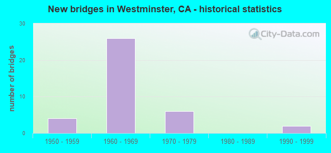
- New bridges - historical statistics
- 41950-1959
- 261960-1969
- 61970-1979
- 21990-1999

- Reconstructed bridges - Historical Statistics
- 51960-1969
- 01970-1979
- 21980-1989
- 01990-1999
- 12000-2009


- Bridge Condition - Deck
- 62.5%Good
- 37.5%Fair

- Bridge Condition - Superstructure
- 62.5%Good
- 37.5%Fair

- Bridge Condition - Substructure
- 75.0%Good
- 25.0%Fair

- Bridge Condition - Channel
- 45.0%Excellent
- 55.0%Very good

- Bridge Condition - Culverts
- 78.9%Good
- 21.1%Satisfactory
Find on map >> Show street view
Structure Number: 55 0085, Location: 12-ORA-022-R2.37-WTM (Lat: 33.774214, Lng: -118.008111), Route carried "on" structure: State highway 22, Year Built: 1958, Year Reconstructed: 1965, Status: Open, Structure Length: 0.81m (2.66ft), Average Daily Traffic: 105,000 (year 2020), Truck Traffic: 9%, Average Future Daily Traffic: 125,000 (year 2038), Design Load: HS 20, Features Intersected: ANAHEIM-BARBER CITY CHAN
Minimum Vertical Clearance: 30+ m (98+ ft), Kilometerpoint: 2.370, Lanes on structure: 8, Base Highway Network: Yes (, Subroute: 1), Owner: State Highway Agency, Approaching Roadway Width: 21.3m (69.9ft), Skew: 35 degrees, Material/Design: Concrete continuous, Design/Construction: Culvert, Number Of Spans In Main Unit: 2, Length of Maximum Span: 3.6m (11.8ft), Curb-To-Curb Width: 21.3m (69.9ft), Out-to-Out Width: 22.3m (73.2ft)
Condition: Channel: Very good, Culverts: Good, Operating Rating: 54.1 metric tons, Method Used To Determine Operating Rating: Field evaluation and documented engineering judgment, Inventory Rating: 32.4 metric tons, Method Used To Determine Inventory Rating: Field evaluation and documented engineering judgment, Structural Evaluation: Better than present minimum criteria, Deck Geometry: High priority of replacement, Waterway Adequacy: Equal to present desirable criteria, Approach Roadway Alignment: Equal to present desirable criteria, Length Of Structure Improvement: 1.43m (4.69ft), Designated Inspection Frequency: Every 48 months, Inspection Date: April 2020
Find on map >> Show street view
Structure Number: 55 0269, Location: 12-ORA-405-17.21-WTM (Lat: 33.739328, Lng: -117.998061), Route carried "on" structure: Interstate 405, Year Built: 1965, Year Reconstructed: 1989, Status: Open, Structure Length: 5.58m (18.31ft), Average Daily Traffic: 256,000 (year 2013), Truck Traffic: 4%, Average Future Daily Traffic: 343,000 (year 2038), Design Load: HS 20+Mod, Features Intersected: UP RR
Minimum Vertical Clearance: 30+ m (98+ ft), Kilometerpoint: 17.210, Lanes on structure: 10, Base Highway Network: Yes (Inventory Route: 4, Subroute: 1), Owner: State Highway Agency, Approaching Roadway Width: 45.1m (148.0ft), Skew: 34 degrees, Material/Design: Concrete continuous, Design/Construction: Tee Beam, Number Of Spans In Main Unit: 3, Length of Maximum Span: 21.3m (69.9ft), Curb-To-Curb Width: 45.1m (148.0ft), Out-to-Out Width: 47.2m (154.9ft)
Condition: Deck: Good, Superstructure: Good, Substructure: Good, Operating Rating: 54.1 metric tons, Method Used To Determine Operating Rating: Assigned rating based on Load Factor Design (LFD) reported in metric tons, Inventory Rating: 32.4 metric tons, Method Used To Determine Inventory Rating: Assigned rating based on Load Factor Design (LFD) reported in metric tons, Structural Evaluation: Better than present minimum criteria, Deck Geometry: Superior to present desirable criteria, Underclear: Better than present minimum criteria, Approach Roadway Alignment: Equal to present desirable criteria, Designated Inspection Frequency: Every 24 months, Inspection Date: September 2021, Deck Structure Type: Concrete Cast-file-Place
Find on map >> Show street view
Structure Number: 55 0272, Location: 12-ORA-405-18.36-WTM (Lat: 33.750850, Lng: -118.011867), Route carried "on" structure: Interstate 405, Year Built: 1965, Year Reconstructed: 1989, Status: Open, Structure Length: 5.39m (17.68ft), Average Daily Traffic: 256,000 (year 2013), Truck Traffic: 4%, Average Future Daily Traffic: 343,000 (year 2038), Design Load: HS 20+Mod, Features Intersected: NAVY RR SPUR
Minimum Vertical Clearance: 30+ m (98+ ft), Kilometerpoint: 18.360, Lanes on structure: 10, Base Highway Network: Yes (Inventory Route: 4, Subroute: 1), Owner: State Highway Agency, Approaching Roadway Width: 45.1m (148.0ft), Skew: 34 degrees, Material/Design: Concrete continuous, Design/Construction: Tee Beam, Number Of Spans In Main Unit: 3, Length of Maximum Span: 19.5m (64.0ft), Curb-To-Curb Width: 45.1m (148.0ft), Out-to-Out Width: 47.1m (154.5ft)
Condition: Deck: Good, Superstructure: Good, Substructure: Good, Operating Rating: 54.1 metric tons, Method Used To Determine Operating Rating: Assigned rating based on Load Factor Design (LFD) reported in metric tons, Inventory Rating: 32.4 metric tons, Method Used To Determine Inventory Rating: Assigned rating based on Load Factor Design (LFD) reported in metric tons, Structural Evaluation: Better than present minimum criteria, Deck Geometry: Superior to present desirable criteria, Underclear: Equal to present minimum criteria, Approach Roadway Alignment: Equal to present desirable criteria, Length Of Structure Improvement: 5.39m (17.68ft), Designated Inspection Frequency: Every 24 months, Inspection Date: September 2021, Deck Structure Type: Concrete Cast-file-Place
Find on map >> Show street view
Structure Number: 55 0275, Location: 12-ORA-405-19.38-WTM (Lat: 33.760631, Lng: -118.024542), Route carried "on" structure: City street M060, Year Built: 1965, Status: Open, Structure Length: 11.52m (37.80ft), Average Daily Traffic: 15,000 (year 2013), Truck Traffic: 3%, Average Future Daily Traffic: 17,694 (year 2038), Design Load: HS 20+Mod, Features Intersected: ROUTE 405, Facility Carried by Structure: SPRINGDALE ST
Minimum Vertical Clearance: 30+ m (98+ ft), Kilometerpoint: 0.000, Lanes on structure: 4, Lanes under structure: 12, Owner: State Highway Agency, Approaching Roadway Width: 17.1m (56.1ft), Skew: 4 degrees, Material/Design: Concrete continuous, Design/Construction: Box Beam or Girders - Multiple, Number Of Spans In Main Unit: 4, Length of Maximum Span: 36.6m (120.1ft), Curb or Sidewalk Widths: Left: 0.0m, Right: 1.5m (4.9ft), Curb-To-Curb Width: 17.1m (56.1ft), Out-to-Out Width: 19.6m (64.3ft)
Condition: Deck: Good, Superstructure: Fair, Substructure: Fair, Operating Rating: 54.1 metric tons, Method Used To Determine Operating Rating: Assigned rating based on Load Factor Design (LFD) reported in metric tons, Inventory Rating: 32.4 metric tons, Method Used To Determine Inventory Rating: Assigned rating based on Load Factor Design (LFD) reported in metric tons, Structural Evaluation: Somewhat better than minimum adequacy, Deck Geometry: Somewhat better than minimum adequacy, Underclear: High priority of corrective action, Approach Roadway Alignment: Equal to present desirable criteria, Designated Inspection Frequency: Every 24 months, Inspection Date: September 2021, Deck Structure Type: Concrete Cast-file-Place
Find on map >> Show street view
Structure Number: 55 0276, Location: 12-ORA-405-20.56-WTM (Lat: 33.772958, Lng: -118.039453), Route carried "on" structure: City street L097, Year Built: 1965, Status: Open, Structure Length: 7.77m (25.49ft), Average Daily Traffic: 15,000 (year 2013), Truck Traffic: 3%, Average Future Daily Traffic: 17,694 (year 2038), Design Load: HS 20+Mod, Features Intersected: ROUTE 405, Facility Carried by Structure: BOLSA CHICA RD
Minimum Vertical Clearance: 30+ m (98+ ft), Kilometerpoint: 0.000, Lanes on structure: 4, Lanes under structure: 11, Owner: State Highway Agency, Approaching Roadway Width: 22.3m (73.2ft), Skew: 20 degrees, Material/Design: Concrete continuous, Design/Construction: Box Beam or Girders - Multiple, Number Of Spans In Main Unit: 4, Length of Maximum Span: 24.1m (79.1ft), Curb or Sidewalk Widths: Left: 0.6m (2.0ft), Right: 1.5m (4.9ft), Curb-To-Curb Width: 22.3m (73.2ft), Out-to-Out Width: 25.3m (83.0ft)
Condition: Deck: Good, Superstructure: Good, Substructure: Good, Operating Rating: 54.1 metric tons, Method Used To Determine Operating Rating: Assigned rating based on Load Factor Design (LFD) reported in metric tons, Inventory Rating: 32.4 metric tons, Method Used To Determine Inventory Rating: Assigned rating based on Load Factor Design (LFD) reported in metric tons, Structural Evaluation: Better than present minimum criteria, Deck Geometry: Superior to present desirable criteria, Underclear: High priority of corrective action, Approach Roadway Alignment: Equal to present desirable criteria, Designated Inspection Frequency: Every 48 months, Inspection Date: September 2021, Deck Structure Type: Concrete Cast-file-Place, Wearing Surface/Protective System: Wearing Surface: Monolithic Concrete
Find on map >> Show street view
Structure Number: 55 0282, Location: 12-ORA-039-7.14-WTM (Lat: 33.752175, Lng: -117.989356), Route carried "on" structure: State highway 39, Year Built: 1954, Year Reconstructed: 1969, Status: Open, Structure Length: 1.62m (5.31ft), Average Daily Traffic: 59,000 (year 2009), Truck Traffic: 2%, Average Future Daily Traffic: 69,829 (year 2044), Features Intersected: WESTMINSTER STORM DRAIN
Minimum Vertical Clearance: 30+ m (98+ ft), Kilometerpoint: 7.140, Lanes on structure: 8, Base Highway Network: Yes (, Subroute: 1), Owner: State Highway Agency, Approaching Roadway Width: 29.9m (98.1ft), Skew: 24 degrees, Material/Design: Concrete, Design/Construction: Culvert, Number Of Spans In Main Unit: 4, Length of Maximum Span: 5.5m (18.0ft), Curb or Sidewalk Widths: Left: 0.0m, Right: 1.8m (5.9ft), Curb-To-Curb Width: 29.9m (98.1ft), Out-to-Out Width: 30.9m (101.4ft)
Condition: Channel: Very good, Culverts: Satisfactory, Operating Rating: 54.1 metric tons, Method Used To Determine Operating Rating: Field evaluation and documented engineering judgment, Inventory Rating: 32.4 metric tons, Method Used To Determine Inventory Rating: Field evaluation and documented engineering judgment, Structural Evaluation: Equal to present minimum criteria, Deck Geometry: Meets minimum limits, Waterway Adequacy: Equal to present desirable criteria, Approach Roadway Alignment: Equal to present desirable criteria, Designated Inspection Frequency: Every 48 months, Inspection Date: January 2022
Find on map >> Show street view
Structure Number: 55 033, Location: 12-ORA-005-9.51-SJCP (Lat: 33.500878, Lng: -117.658156), Route carried "on" structure: Interstate 5, Year Built: 1958, Year Reconstructed: 1969, Status: Open, Structure Length: 0.67m (2.20ft), Average Daily Traffic: 237,000 (year 2019), Truck Traffic: 4%, Average Future Daily Traffic: 298,413 (year 2043), Features Intersected: EL HORNO CREEK
Minimum Vertical Clearance: 30+ m (98+ ft), Kilometerpoint: 9.510, Lanes on structure: 12, Base Highway Network: Yes (, Subroute: 1), Owner: State Highway Agency, Approaching Roadway Width: 38.1m (125.0ft), Skew: 23 degrees, Material/Design: Concrete, Design/Construction: Culvert, Number Of Spans In Main Unit: 2, Length of Maximum Span: 3.7m (12.1ft)
Condition: Channel: Very good, Culverts: Good, Operating Rating: 54.1 metric tons, Method Used To Determine Operating Rating: Field evaluation and documented engineering judgment, Inventory Rating: 32.4 metric tons, Method Used To Determine Inventory Rating: Field evaluation and documented engineering judgment, Structural Evaluation: Better than present minimum criteria, Waterway Adequacy: Equal to present desirable criteria, Approach Roadway Alignment: Equal to present desirable criteria, Designated Inspection Frequency: Every 24 months, Inspection Date: April 2021
Find on map >> Show street view
Structure Number: 55 0338, Location: 12-ORA-022-R3.20-WTM (Lat: 33.771275, Lng: -117.999053), Route carried "on" structure: State highway 22, Year Built: 1964, Year Reconstructed: 2007, Status: Open, Structure Length: 7.46m (24.48ft), Average Daily Traffic: 200,000 (year 2020), Truck Traffic: 9%, Average Future Daily Traffic: 273,000 (year 2038), Design Load: HS 20+Mod, Features Intersected: UP RR & HOOVER STREET
Minimum Vertical Clearance: 30+ m (98+ ft), Kilometerpoint: 3.200, Lanes on structure: 10, Lanes under structure: 5, Base Highway Network: Yes (, Subroute: 1), Owner: State Highway Agency, Approaching Roadway Width: 50.9m (167.0ft), Skew: 30 degrees, Material/Design: Concrete continuous, Design/Construction: Box Beam or Girders - Multiple, Number Of Spans In Main Unit: 4, Length of Maximum Span: 28.4m (93.2ft), Curb-To-Curb Width: 50.9m (167.0ft), Out-to-Out Width: 51.9m (170.3ft)
Condition: Deck: Good, Superstructure: Good, Substructure: Good, Operating Rating: 54.1 metric tons, Method Used To Determine Operating Rating: Assigned rating based on Load Factor Design (LFD) reported in metric tons, Inventory Rating: 32.4 metric tons, Method Used To Determine Inventory Rating: Assigned rating based on Load Factor Design (LFD) reported in metric tons, Structural Evaluation: Better than present minimum criteria, Deck Geometry: Superior to present desirable criteria, Underclear: Equal to present minimum criteria, Approach Roadway Alignment: Equal to present desirable criteria, Designated Inspection Frequency: Every 48 months, Inspection Date: April 2020, Deck Structure Type: Concrete Cast-file-Place
Find on map >> Show street view
Structure Number: 55 0368, Location: 12-ORA-022-R3.57-WTM (Lat: 33.770867, Lng: -117.992650), Route carried "on" structure: State highway 22, Year Built: 1964, Status: Open, Structure Length: 7.34m (24.08ft), Average Daily Traffic: 185,000 (year 2020), Truck Traffic: 9%, Average Future Daily Traffic: 193,000 (year 2038), Design Load: HS 20+Mod, Features Intersected: SR 39 (BEACH BLVD)
Minimum Vertical Clearance: 30+ m (98+ ft), Kilometerpoint: 3.570, Lanes on structure: 10, Lanes under structure: 10, Base Highway Network: Yes (, Subroute: 1), Owner: State Highway Agency, Approaching Roadway Width: 58.5m (191.9ft), Skew: 32 degrees, Material/Design: Concrete continuous, Design/Construction: Box Beam or Girders - Multiple, Number Of Spans In Main Unit: 4, Length of Maximum Span: 26.8m (87.9ft), Curb-To-Curb Width: 58.5m (191.9ft), Out-to-Out Width: 61.0m (200.1ft)
Condition: Deck: Fair, Superstructure: Good, Substructure: Fair, Operating Rating: 54.1 metric tons, Method Used To Determine Operating Rating: Assigned rating based on Load Factor Design (LFD) reported in metric tons, Inventory Rating: 32.4 metric tons, Method Used To Determine Inventory Rating: Assigned rating based on Load Factor Design (LFD) reported in metric tons, Structural Evaluation: Somewhat better than minimum adequacy, Deck Geometry: Superior to present desirable criteria, Underclear: Equal to present minimum criteria, Approach Roadway Alignment: Equal to present desirable criteria, Length Of Structure Improvement: 7.35m (24.11ft), Designated Inspection Frequency: Every 24 months, Inspection Date: November 2020, Deck Structure Type: Concrete Cast-file-Place
Find on map >> Show street view
Structure Number: 55 0398, Location: 12-ORA-022-R1.93-WTM (Lat: 33.774572, Lng: -118.020306), Route carried "on" structure: City street M060, Year Built: 1966, Status: Open, Structure Length: 10.97m (35.99ft), Average Daily Traffic: 12,000 (year 2020), Truck Traffic: 3%, Average Future Daily Traffic: 13,640 (year 2038), Design Load: HS 20, Features Intersected: STATE ROUTE 22, Facility Carried by Structure: SPRINGDALE ST
Minimum Vertical Clearance: 30+ m (98+ ft), Kilometerpoint: 0.000, Lanes on structure: 4, Lanes under structure: 12, Owner: State Highway Agency, Approaching Roadway Width: 15.8m (51.8ft), Skew: 2 degrees, Material/Design: Concrete continuous, Design/Construction: Box Beam or Girders - Multiple, Number Of Spans In Main Unit: 5, Length of Maximum Span: 31.1m (102.0ft), Curb or Sidewalk Widths: Left: 1.5m (4.9ft), Right: 0.6m (2.0ft), Curb-To-Curb Width: 15.8m (51.8ft), Out-to-Out Width: 18.6m (61.0ft)
Condition: Deck: Fair, Superstructure: Fair, Substructure: Good, Operating Rating: 39.9 metric tons, Method Used To Determine Operating Rating: Load and Resistance Factor Rating (LRFR) rating reported by rating factor(RF) method using HL-93 loadings, Inventory Rating: 30.8 metric tons, Method Used To Determine Inventory Rating: Load and Resistance Factor Rating (LRFR) rating reported by rating factor(RF) method using HL-93 loadings, Structural Evaluation: Somewhat better than minimum adequacy, Deck Geometry: Meets minimum limits, Underclear: High priority of corrective action, Approach Roadway Alignment: Better than present minimum criteria, Designated Inspection Frequency: Every 24 months, Inspection Date: April 2020, Deck Structure Type: Concrete Cast-file-Place
Find on map >> Show street view
Structure Number: 55 0461, Location: 12-ORA-405-19.45-WTM (Lat: 33.762169, Lng: -118.025425), Route carried "on" structure: Interstate 405, Year Built: 1965, Status: Open, Structure Length: 1.28m (4.20ft), Average Daily Traffic: 256,000 (year 2013), Truck Traffic: 4%, Average Future Daily Traffic: 343,000 (year 2038), Features Intersected: ANAHEIM-BARBER CITY CH
Minimum Vertical Clearance: 30+ m (98+ ft), Kilometerpoint: 19.450, Lanes on structure: 11, Base Highway Network: Yes (Inventory Route: 4, Subroute: 1), Owner: State Highway Agency, Approaching Roadway Width: 60.4m (198.2ft), Skew: 20 degrees, Material/Design: Concrete, Design/Construction: Culvert, Number Of Spans In Main Unit: 4, Length of Maximum Span: 3.4m (11.2ft), Curb-To-Curb Width: 60.4m (198.2ft), Out-to-Out Width: 61.4m (201.4ft)
Condition: Channel: Very good, Culverts: Satisfactory, Operating Rating: 54.1 metric tons, Method Used To Determine Operating Rating: Field evaluation and documented engineering judgment, Inventory Rating: 32.4 metric tons, Method Used To Determine Inventory Rating: Field evaluation and documented engineering judgment, Structural Evaluation: Equal to present minimum criteria, Deck Geometry: Superior to present desirable criteria, Waterway Adequacy: Equal to present desirable criteria, Approach Roadway Alignment: Equal to present desirable criteria, Designated Inspection Frequency: Every 24 months, Inspection Date: September 2021
Find on map >> Show street view
Structure Number: 55 0462, Location: 12-ORA-405-17.80-WTM (Lat: 33.745906, Lng: -118.005972), Route carried "on" structure: Interstate 405, Year Built: 1965, Status: Open, Structure Length: 0.76m (2.49ft), Average Daily Traffic: 256,000 (year 2013), Truck Traffic: 4%, Average Future Daily Traffic: 343,000 (year 2038), Features Intersected: WESTMINSTER CHANNEL
Minimum Vertical Clearance: 30+ m (98+ ft), Kilometerpoint: 17.800, Lanes on structure: 10, Base Highway Network: Yes (Inventory Route: 4, Subroute: 1), Owner: State Highway Agency, Approaching Roadway Width: 45.1m (148.0ft), Skew: 20 degrees, Material/Design: Concrete, Design/Construction: Culvert, Number Of Spans In Main Unit: 2, Length of Maximum Span: 4.0m (13.1ft), Curb-To-Curb Width: 45.1m (148.0ft), Out-to-Out Width: 46.1m (151.2ft)
Condition: Channel: Very good, Culverts: Good, Operating Rating: 54.1 metric tons, Method Used To Determine Operating Rating: Field evaluation and documented engineering judgment, Inventory Rating: 32.4 metric tons, Method Used To Determine Inventory Rating: Field evaluation and documented engineering judgment, Structural Evaluation: Better than present minimum criteria, Deck Geometry: Superior to present desirable criteria, Waterway Adequacy: Equal to present desirable criteria, Approach Roadway Alignment: Equal to present desirable criteria, Designated Inspection Frequency: Every 24 months, Inspection Date: September 2021
Find on map >> Show street view
Structure Number: 55C0093, Location: AT MCFADDEN AVENUE (Lat: 33.737814, Lng: -117.954394), Route carried "on" structure: City street , Year Built: 1960, Status: Open, Structure Length: 0.79m (2.59ft), Average Daily Traffic: 38,500 (year 2021), Truck Traffic: 1%, Average Future Daily Traffic: 36,099 (year 2039), Features Intersected: E GARDEN GROVE WBURG CH, Facility Carried by Structure: BROOKHURST STREET
Minimum Vertical Clearance: 30+ m (98+ ft), Kilometerpoint: 0.000, Lanes on structure: 8, Base Highway Network: Yes, Owner: City or Municipal Highway Agency, Approaching Roadway Width: 29.5m (96.8ft), Skew: 33 degrees, Material/Design: Concrete, Design/Construction: Culvert, Number Of Spans In Main Unit: 2, Length of Maximum Span: 4.5m (14.8ft), Curb or Sidewalk Widths: Left: 2.4m (7.9ft), Right: 3.7m (12.1ft), Curb-To-Curb Width: 29.5m (96.8ft), Out-to-Out Width: 36.5m (119.8ft)
Condition: Channel: Very good, Culverts: Good, Operating Rating: 40.5 metric tons, Method Used To Determine Operating Rating: Field evaluation and documented engineering judgment, Inventory Rating: 24.3 metric tons, Method Used To Determine Inventory Rating: Field evaluation and documented engineering judgment, Structural Evaluation: Equal to present minimum criteria, Deck Geometry: Meets minimum limits, Waterway Adequacy: Equal to present desirable criteria, Approach Roadway Alignment: Equal to present desirable criteria, Designated Inspection Frequency: Every 24 months, Inspection Date: April 2021, Deck Structure Type: Concrete Cast-file-Place, Wearing Surface/Protective System: Wearing Surface: Bituminous
Find on map >> Show street view
Structure Number: 55C0108, Location: 100' W BOLSA CHICA RD (Lat: 33.759314, Lng: -118.043194), Route carried "on" structure: City street , Year Built: 1959, Year Reconstructed: 1972, Status: Open, Structure Length: 3.20m (10.50ft), Average Daily Traffic: 22,250 (year 2019), Truck Traffic: 1%, Average Future Daily Traffic: 27,421 (year 2039), Design Load: HS 20, Features Intersected: BOLSA CHICA CHANNEL, Facility Carried by Structure: WESTMINSTER AVE
Minimum Vertical Clearance: 30+ m (98+ ft), Kilometerpoint: 0.000, Lanes on structure: 6, Base Highway Network: Yes, Owner: City or Municipal Highway Agency, Approaching Roadway Width: 24.0m (78.7ft), Skew: 30 degrees, Material/Design: Concrete continuous, Design/Construction: Slab, Number Of Spans In Main Unit: 3, Length of Maximum Span: 10.4m (34.1ft), Curb or Sidewalk Widths: Left: 1.2m (3.9ft), Right: 1.2m (3.9ft), Curb-To-Curb Width: 24.0m (78.7ft), Out-to-Out Width: 27.7m (90.9ft)
Condition: Deck: Fair, Superstructure: Fair, Substructure: Good, Channel: Very good, Operating Rating: 73.2 metric tons, Method Used To Determine Operating Rating: Load Factor (LF), Inventory Rating: 44.1 metric tons, Method Used To Determine Inventory Rating: Load Factor (LF), Structural Evaluation: Somewhat better than minimum adequacy, Deck Geometry: Somewhat better than minimum adequacy, Waterway Adequacy: Superior to present desirable criteria, Approach Roadway Alignment: Equal to present desirable criteria, Designated Inspection Frequency: Every 24 months, Inspection Date: April 2021, Deck Structure Type: Concrete Cast-file-Place, Wearing Surface/Protective System: Wearing Surface: Monolithic Concrete
Find on map >> Show street view
Structure Number: 55C0135, Location: 0.1 MI S ROUTE 1-405 (Lat: 33.745133, Lng: -118.006786), Route carried "on" structure: City street , Year Built: 1965, Status: Open, Structure Length: 1.13m (3.71ft), Average Daily Traffic: 39,000 (year 2021), Truck Traffic: 1%, Average Future Daily Traffic: 50,794 (year 2039), Features Intersected: WESTMINSTER CHANNEL, Facility Carried by Structure: GOLDEN WEST ST
Minimum Vertical Clearance: 30+ m (98+ ft), Kilometerpoint: 0.000, Lanes on structure: 7, Base Highway Network: Yes, Owner: City or Municipal Highway Agency, Approaching Roadway Width: 30.9m (101.4ft), Skew: 34 degrees, Material/Design: Concrete, Design/Construction: Culvert, Number Of Spans In Main Unit: 2, Length of Maximum Span: 5.2m (17.1ft), Curb or Sidewalk Widths: Left: 1.8m (5.9ft), Right: 2.4m (7.9ft), Curb-To-Curb Width: 30.9m (101.4ft), Out-to-Out Width: 40.7m (133.5ft)
Condition: Channel: Excellent, Culverts: Good, Operating Rating: 54.1 metric tons, Method Used To Determine Operating Rating: Field evaluation and documented engineering judgment, Inventory Rating: 32.4 metric tons, Method Used To Determine Inventory Rating: Field evaluation and documented engineering judgment, Structural Evaluation: Better than present minimum criteria, Deck Geometry: Better than present minimum criteria, Waterway Adequacy: Superior to present desirable criteria, Approach Roadway Alignment: Equal to present desirable criteria, Designated Inspection Frequency: Every 48 months, Inspection Date: April 2021
Find on map >> Show street view
Structure Number: 55C0157, Location: 0.6 MI S/O WESTMINISTER (Lat: 33.750500, Lng: -118.041697), Route carried "on" structure: City street , Year Built: 1976, Status: Open, Structure Length: 2.23m (7.32ft), Average Daily Traffic: 45,500 (year 2021), Truck Traffic: 1%, Average Future Daily Traffic: 35,860 (year 2039), Features Intersected: ANAHEIM BARBER CITY CH, Facility Carried by Structure: BOLSA CHICA RD
Minimum Vertical Clearance: 30+ m (98+ ft), Kilometerpoint: 0.000, Lanes on structure: 8, Base Highway Network: Yes, Owner: City or Municipal Highway Agency, Approaching Roadway Width: 28.6m (93.8ft), Skew: 32 degrees, Material/Design: Concrete, Design/Construction: Culvert, Number Of Spans In Main Unit: 4, Length of Maximum Span: 4.9m (16.1ft), Curb or Sidewalk Widths: Left: 0.2m (0.7ft), Right: 2.5m (8.2ft), Curb-To-Curb Width: 28.6m (93.8ft), Out-to-Out Width: 34.2m (112.2ft)
Condition: Channel: Excellent, Culverts: Good, Operating Rating: 54.1 metric tons, Method Used To Determine Operating Rating: Field evaluation and documented engineering judgment, Inventory Rating: 32.4 metric tons, Method Used To Determine Inventory Rating: Field evaluation and documented engineering judgment, Structural Evaluation: Better than present minimum criteria, Deck Geometry: High priority of replacement, Waterway Adequacy: Superior to present desirable criteria, Approach Roadway Alignment: Equal to present desirable criteria, Designated Inspection Frequency: Every 48 months, Inspection Date: April 2021, Deck Structure Type: Concrete Cast-file-Place, Wearing Surface/Protective System: Wearing Surface: Bituminous
Find on map >> Show street view
Structure Number: 55C0162, Location: AT RANCH RD (Lat: 33.758883, Lng: -118.030272), Route carried "on" structure: City street , Year Built: 1976, Status: Open, Structure Length: 1.98m (6.50ft), Average Daily Traffic: 27,000 (year 2021), Truck Traffic: 1%, Average Future Daily Traffic: 20,039 (year 2039), Features Intersected: ANAHEIM-BARBER CITY CHAN, Facility Carried by Structure: WESTMINISTER BLVD
Minimum Vertical Clearance: 30+ m (98+ ft), Kilometerpoint: 0.000, Lanes on structure: 6, Base Highway Network: Yes, Owner: City or Municipal Highway Agency, Approaching Roadway Width: 26.2m (86.0ft), Skew: 4 degrees, Material/Design: Concrete, Design/Construction: Culvert, Number Of Spans In Main Unit: 3, Length of Maximum Span: 6.6m (21.7ft), Curb or Sidewalk Widths: Left: 2.5m (8.2ft), Right: 2.5m (8.2ft), Curb-To-Curb Width: 26.2m (86.0ft), Out-to-Out Width: 31.2m (102.4ft)
Condition: Channel: Excellent, Culverts: Good, Operating Rating: 54.1 metric tons, Method Used To Determine Operating Rating: Field evaluation and documented engineering judgment, Inventory Rating: 32.4 metric tons, Method Used To Determine Inventory Rating: Field evaluation and documented engineering judgment, Structural Evaluation: Better than present minimum criteria, Deck Geometry: Equal to present minimum criteria, Waterway Adequacy: Superior to present desirable criteria, Approach Roadway Alignment: Equal to present desirable criteria, Designated Inspection Frequency: Every 48 months, Inspection Date: April 2021
Find on map >> Show street view
Structure Number: 55C0402, Location: 0.2 MI N TRASK AVE (Lat: 33.768675, Lng: -118.015772), Route carried "on" structure: City street , Year Built: 1975, Status: Open, Structure Length: 1.92m (6.30ft), Average Daily Traffic: 9,500 (year 2019), Truck Traffic: 1%, Average Future Daily Traffic: 10,618 (year 2037), Features Intersected: ANAHEIM-BARBER CITY CHA, Facility Carried by Structure: EDWARDS ST
Minimum Vertical Clearance: 30+ m (98+ ft), Kilometerpoint: 0.000, Lanes on structure: 4, Owner: City or Municipal Highway Agency, Approaching Roadway Width: 18.9m (62.0ft), Skew: 3 degrees, Material/Design: Concrete, Design/Construction: Culvert, Number Of Spans In Main Unit: 3, Length of Maximum Span: 6.1m (20.0ft), Curb or Sidewalk Widths: Left: 2.1m (6.9ft), Right: 2.5m (8.2ft), Curb-To-Curb Width: 18.9m (62.0ft), Out-to-Out Width: 24.3m (79.7ft)
Condition: Channel: Excellent, Culverts: Good, Operating Rating: 54.1 metric tons, Method Used To Determine Operating Rating: Field evaluation and documented engineering judgment, Inventory Rating: 32.4 metric tons, Method Used To Determine Inventory Rating: Field evaluation and documented engineering judgment, Structural Evaluation: Better than present minimum criteria, Deck Geometry: Equal to present minimum criteria, Waterway Adequacy: Superior to present desirable criteria, Approach Roadway Alignment: Equal to present desirable criteria, Designated Inspection Frequency: Every 48 months, Inspection Date: April 2019, Deck Structure Type: Concrete Cast-file-Place, Wearing Surface/Protective System: Wearing Surface: Bituminous
Find on map >> Show street view
Structure Number: 55C0424, Location: 0.25 MI N EDINGER AVE (Lat: 33.734025, Lng: -117.963286), Route carried "on" structure: City street , Year Built: 1961, Status: Open, Structure Length: 1.04m (3.41ft), Average Daily Traffic: 17,500 (year 2021), Truck Traffic: 1%, Average Future Daily Traffic: 11,601 (year 2039), Features Intersected: E GRDN GRVE WNTERBG CHAN, Facility Carried by Structure: BUSHARD STREET
Minimum Vertical Clearance: 30+ m (98+ ft), Kilometerpoint: 0.000, Lanes on structure: 4, Owner: City or Municipal Highway Agency, Approaching Roadway Width: 19.2m (63.0ft), Skew: 2 degrees, Material/Design: Concrete, Design/Construction: Culvert, Number Of Spans In Main Unit: 2, Length of Maximum Span: 4.3m (14.1ft), Curb or Sidewalk Widths: Left: 2.4m (7.9ft), Right: 2.5m (8.2ft), Curb-To-Curb Width: 19.2m (63.0ft), Out-to-Out Width: 24.5m (80.4ft)
Condition: Channel: Very good, Culverts: Good, Operating Rating: 40.5 metric tons, Method Used To Determine Operating Rating: Field evaluation and documented engineering judgment, Inventory Rating: 24.3 metric tons, Method Used To Determine Inventory Rating: Field evaluation and documented engineering judgment, Structural Evaluation: Equal to present minimum criteria, Deck Geometry: Equal to present minimum criteria, Waterway Adequacy: Equal to present desirable criteria, Approach Roadway Alignment: Equal to present desirable criteria, Designated Inspection Frequency: Every 24 months, Inspection Date: April 2021, Deck Structure Type: Concrete Cast-file-Place, Wearing Surface/Protective System: Wearing Surface: Bituminous
Find on map >> Show street view
Structure Number: 55C0426, Location: 0.10 MI N MCFADDEN AVE (Lat: 33.739081, Lng: -117.945972), Route carried "on" structure: City street , Year Built: 1961, Status: Open, Structure Length: 0.79m (2.59ft), Average Daily Traffic: 12,500 (year 2021), Truck Traffic: 1%, Average Future Daily Traffic: 8,493 (year 2039), Features Intersected: E GRDN GRVE WINTRBG CHAN, Facility Carried by Structure: WARD STREET
Minimum Vertical Clearance: 30+ m (98+ ft), Kilometerpoint: 0.000, Lanes on structure: 3, Owner: City or Municipal Highway Agency, Approaching Roadway Width: 19.4m (63.6ft), Material/Design: Concrete, Design/Construction: Culvert, Number Of Spans In Main Unit: 2, Length of Maximum Span: 3.7m (12.1ft), Curb or Sidewalk Widths: Left: 2.4m (7.9ft), Right: 1.3m (4.3ft), Curb-To-Curb Width: 19.4m (63.6ft), Out-to-Out Width: 23.0m (75.5ft)
Condition: Channel: Very good, Culverts: Satisfactory, Operating Rating: 40.5 metric tons, Method Used To Determine Operating Rating: Field evaluation and documented engineering judgment, Inventory Rating: 24.3 metric tons, Method Used To Determine Inventory Rating: Field evaluation and documented engineering judgment, Structural Evaluation: Equal to present minimum criteria, Deck Geometry: Superior to present desirable criteria, Waterway Adequacy: Equal to present desirable criteria, Approach Roadway Alignment: Equal to present desirable criteria, Designated Inspection Frequency: Every 24 months, Inspection Date: April 2021, Deck Structure Type: Concrete Cast-file-Place, Wearing Surface/Protective System: Wearing Surface: Bituminous
Find on map >> Show street view
Structure Number: 55C0427, Location: AT EDINGER AVE (Lat: 33.730461, Lng: -117.971647), Route carried "on" structure: City street , Year Built: 1961, Status: Open, Structure Length: 0.82m (2.69ft), Average Daily Traffic: 33,000 (year 2021), Truck Traffic: 1%, Average Future Daily Traffic: 34,089 (year 2039), Features Intersected: E GRDN GRVE WINTRBG CHAN, Facility Carried by Structure: MAGNOLIA ST
Minimum Vertical Clearance: 30+ m (98+ ft), Kilometerpoint: 0.000, Lanes on structure: 8, Base Highway Network: Yes, Owner: City or Municipal Highway Agency, Approaching Roadway Width: 25.3m (83.0ft), Skew: 2 degrees, Material/Design: Concrete, Design/Construction: Culvert, Number Of Spans In Main Unit: 2, Length of Maximum Span: 3.7m (12.1ft), Curb or Sidewalk Widths: Left: 2.4m (7.9ft), Right: 2.4m (7.9ft), Curb-To-Curb Width: 25.3m (83.0ft), Out-to-Out Width: 30.1m (98.8ft)
Condition: Channel: Very good, Culverts: Good, Operating Rating: 40.5 metric tons, Method Used To Determine Operating Rating: Field evaluation and documented engineering judgment, Inventory Rating: 24.3 metric tons, Method Used To Determine Inventory Rating: Field evaluation and documented engineering judgment, Structural Evaluation: Equal to present minimum criteria, Deck Geometry: High priority of replacement, Waterway Adequacy: Superior to present desirable criteria, Approach Roadway Alignment: Equal to present desirable criteria, Designated Inspection Frequency: Every 24 months, Inspection Date: April 2021, Deck Structure Type: Concrete Cast-file-Place, Wearing Surface/Protective System: Wearing Surface: Bituminous
Find on map >> Show street view
Structure Number: 55C0457, Location: 100' N BOLSA AVE (Lat: 33.744628, Lng: -118.015592), Route carried "on" structure: City street , Year Built: 1965, Year Reconstructed: 1972, Status: Open, Structure Length: 1.37m (4.49ft), Average Daily Traffic: 17,000 (year 2021), Truck Traffic: 1%, Average Future Daily Traffic: 19,048 (year 2039), Features Intersected: WESTMINSTER CHANNEL, Facility Carried by Structure: EDWARDS ST
Minimum Vertical Clearance: 30+ m (98+ ft), Kilometerpoint: 0.000, Lanes on structure: 5, Owner: City or Municipal Highway Agency, Approaching Roadway Width: 19.5m (64.0ft), Material/Design: Concrete, Design/Construction: Culvert, Number Of Spans In Main Unit: 4, Length of Maximum Span: 3.0m (9.8ft), Curb or Sidewalk Widths: Left: 2.4m (7.9ft), Right: 2.4m (7.9ft), Curb-To-Curb Width: 19.5m (64.0ft), Out-to-Out Width: 32.3m (106.0ft)
Condition: Channel: Very good, Culverts: Good, Operating Rating: 40.5 metric tons, Method Used To Determine Operating Rating: Field evaluation and documented engineering judgment, Inventory Rating: 24.3 metric tons, Method Used To Determine Inventory Rating: Field evaluation and documented engineering judgment, Structural Evaluation: Equal to present minimum criteria, Deck Geometry: Meets minimum limits, Waterway Adequacy: Equal to present desirable criteria, Approach Roadway Alignment: Equal to present desirable criteria, Designated Inspection Frequency: Every 24 months, Inspection Date: April 2021, Deck Structure Type: Concrete Cast-file-Place, Wearing Surface/Protective System: Wearing Surface: Bituminous
Find on map >> Show street view
Structure Number: 55C0545, Location: 0.3 MI S WESTMINSTER AVE (Lat: 33.755589, Lng: -117.980922), Route carried "on" structure: City street , Year Built: 1978, Status: Open, Structure Length: 0.82m (2.69ft), Average Daily Traffic: 18,000 (year 2019), Truck Traffic: 1%, Average Future Daily Traffic: 13,803 (year 2037), Features Intersected: WESTMINSTER CHANNEL, Facility Carried by Structure: NEWLAND ST
Minimum Vertical Clearance: 30+ m (98+ ft), Kilometerpoint: 0.000, Lanes on structure: 5, Owner: City or Municipal Highway Agency, Approaching Roadway Width: 19.2m (63.0ft), Material/Design: Concrete, Design/Construction: Culvert, Number Of Spans In Main Unit: 2, Length of Maximum Span: 3.7m (12.1ft), Curb or Sidewalk Widths: Left: 2.5m (8.2ft), Right: 2.4m (7.9ft), Curb-To-Curb Width: 19.4m (63.6ft), Out-to-Out Width: 24.7m (81.0ft)
Condition: Channel: Excellent, Culverts: Good, Operating Rating: 54.1 metric tons, Method Used To Determine Operating Rating: Field evaluation and documented engineering judgment, Inventory Rating: 32.4 metric tons, Method Used To Determine Inventory Rating: Field evaluation and documented engineering judgment, Structural Evaluation: Better than present minimum criteria, Deck Geometry: Meets minimum limits, Waterway Adequacy: Superior to present desirable criteria, Approach Roadway Alignment: Equal to present desirable criteria, Designated Inspection Frequency: Every 48 months, Inspection Date: April 2019
Find on map >> Show street view
Structure Number: 55C0546, Location: 200' S HAZARD AVE (Lat: 33.751561, Lng: -117.998111), Route carried "on" structure: City street , Year Built: 1974, Status: Open, Structure Length: 1.92m (6.30ft), Average Daily Traffic: 8,000 (year 2021), Truck Traffic: 1%, Average Future Daily Traffic: 11,000 (year 2039), Features Intersected: WESTMINSTER CHANNEL, Facility Carried by Structure: HOOVER ST
Minimum Vertical Clearance: 30+ m (98+ ft), Kilometerpoint: 0.000, Lanes on structure: 4, Owner: City or Municipal Highway Agency, Approaching Roadway Width: 19.5m (64.0ft), Skew: 4 degrees, Material/Design: Concrete, Design/Construction: Culvert, Number Of Spans In Main Unit: 4, Length of Maximum Span: 4.9m (16.1ft), Curb or Sidewalk Widths: Left: 0.2m (0.7ft), Right: 0.2m (0.7ft), Curb-To-Curb Width: 14.5m (47.6ft), Out-to-Out Width: 15.0m (49.2ft)
Condition: Channel: Excellent, Culverts: Good, Operating Rating: 54.1 metric tons, Method Used To Determine Operating Rating: Field evaluation and documented engineering judgment, Inventory Rating: 32.4 metric tons, Method Used To Determine Inventory Rating: Field evaluation and documented engineering judgment, Structural Evaluation: Better than present minimum criteria, Deck Geometry: High priority of replacement, Waterway Adequacy: Superior to present desirable criteria, Approach Roadway Alignment: Equal to present desirable criteria, Designated Inspection Frequency: Every 48 months, Inspection Date: April 2021, Deck Structure Type: Concrete Cast-file-Place, Wearing Surface/Protective System: Wearing Surface: Bituminous
Find on map >> Show street view
Structure Number: 55C0547, Location: 0.3 MI NORTH BOLSA AVE (Lat: 33.748219, Lng: -118.002531), Route carried "on" structure: City street , Year Built: 1974, Status: Open, Structure Length: 1.19m (3.90ft), Average Daily Traffic: 1,500 (year 2021), Truck Traffic: 1%, Average Future Daily Traffic: 2,137 (year 2039), Features Intersected: WESTMINSTER CHANNEL, Facility Carried by Structure: CHESTNUT ST
Minimum Vertical Clearance: 30+ m (98+ ft), Kilometerpoint: 0.000, Lanes on structure: 2, Owner: City or Municipal Highway Agency, Approaching Roadway Width: 14.3m (46.9ft), Skew: 9 degrees, Material/Design: Concrete, Design/Construction: Culvert, Number Of Spans In Main Unit: 3, Length of Maximum Span: 3.7m (12.1ft), Curb or Sidewalk Widths: Left: 0.2m (0.7ft), Right: 1.8m (5.9ft), Curb-To-Curb Width: 14.3m (46.9ft), Out-to-Out Width: 23.0m (75.5ft)
Condition: Channel: Excellent, Culverts: Good, Operating Rating: 54.1 metric tons, Method Used To Determine Operating Rating: Field evaluation and documented engineering judgment, Inventory Rating: 32.4 metric tons, Method Used To Determine Inventory Rating: Field evaluation and documented engineering judgment, Structural Evaluation: Better than present minimum criteria, Deck Geometry: Superior to present desirable criteria, Waterway Adequacy: Superior to present desirable criteria, Approach Roadway Alignment: Equal to present desirable criteria, Designated Inspection Frequency: Every 48 months, Inspection Date: April 2021, Deck Structure Type: Concrete Cast-file-Place, Wearing Surface/Protective System: Wearing Surface: Bituminous
Find on map >> Show street view
Structure Number: 55C0648, Location: 0.2 MI N/O DREY ROAD (Lat: 33.725847, Lng: -117.982331), Route carried "on" structure: City street , Year Built: 1997, Status: Open, Structure Length: 1.90m (6.23ft), Average Daily Traffic: 1,000 (year 2019), Truck Traffic: 1%, Average Future Daily Traffic: 2,124 (year 2037), Design Load: HS 20+Mod, Features Intersected: E GRDN GRVE WNTRSBG CHAN, Facility Carried by Structure: WOODRUFF STREET
Minimum Vertical Clearance: 30+ m (98+ ft), Kilometerpoint: 0.000, Lanes on structure: 2, Owner: City or Municipal Highway Agency, Approaching Roadway Width: 11.0m (36.1ft), Material/Design: Concrete continuous, Design/Construction: Culvert, Number Of Spans In Main Unit: 4, Length of Maximum Span: 4.4m (14.4ft), Curb or Sidewalk Widths: Left: 1.8m (5.9ft), Right: 1.8m (5.9ft), Curb-To-Curb Width: 11.0m (36.1ft), Out-to-Out Width: 15.2m (49.9ft)
Condition: Channel: Excellent, Culverts: Satisfactory, Operating Rating: 54.1 metric tons, Method Used To Determine Operating Rating: Field evaluation and documented engineering judgment, Inventory Rating: 32.4 metric tons, Method Used To Determine Inventory Rating: Field evaluation and documented engineering judgment, Structural Evaluation: Equal to present minimum criteria, Deck Geometry: Better than present minimum criteria, Waterway Adequacy: Superior to present desirable criteria, Approach Roadway Alignment: Equal to present desirable criteria, Designated Inspection Frequency: Every 48 months, Inspection Date: April 2019, Deck Structure Type: Concrete Cast-file-Place, Wearing Surface/Protective System: Wearing Surface: Bituminous
Find on map >> Show street view
Structure Number: 55C0649, Location: 0.1 M S/O EDINGER (Lat: 33.728703, Lng: -117.975642), Route carried "on" structure: City street , Year Built: 1997, Status: Open, Structure Length: 1.90m (6.23ft), Average Daily Traffic: 1,000 (year 2019), Truck Traffic: 1%, Average Future Daily Traffic: 2,124 (year 2037), Design Load: HS 20+Mod, Features Intersected: E GRDN GRVE WNTRSBG CHAN, Facility Carried by Structure: QUARTZ STREET
Minimum Vertical Clearance: 30+ m (98+ ft), Kilometerpoint: 0.000, Lanes on structure: 2, Owner: City or Municipal Highway Agency, Approaching Roadway Width: 11.0m (36.1ft), Material/Design: Concrete continuous, Design/Construction: Culvert, Number Of Spans In Main Unit: 4, Length of Maximum Span: 4.4m (14.4ft), Curb or Sidewalk Widths: Left: 1.8m (5.9ft), Right: 1.8m (5.9ft), Curb-To-Curb Width: 11.0m (36.1ft), Out-to-Out Width: 15.2m (49.9ft)
Condition: Channel: Excellent, Culverts: Good, Operating Rating: 54.1 metric tons, Method Used To Determine Operating Rating: Field evaluation and documented engineering judgment, Inventory Rating: 32.4 metric tons, Method Used To Determine Inventory Rating: Field evaluation and documented engineering judgment, Structural Evaluation: Better than present minimum criteria, Deck Geometry: Better than present minimum criteria, Waterway Adequacy: Equal to present desirable criteria, Approach Roadway Alignment: Equal to present desirable criteria, Designated Inspection Frequency: Every 48 months, Inspection Date: April 2019, Deck Structure Type: Concrete Cast-file-Place, Wearing Surface/Protective System: Wearing Surface: Bituminous
Find on map >> Show street view
Structure Number: 55 027, Location: 12-ORA-405-17.75-WTM (Lat: 33.744489, Lng: -118.005319), Route carried "under" structure: Ramp Interstate 405, Year Built: 1965, Structure Length: 0. m, Average Daily Traffic: 6,700 (year 2013), Truck Traffic: 3%, Features Intersected: ROUTE 405, Facility Carried by Structure: BOLSA AVE
Minimum Vertical Clearance: 5.35m (17.55ft), Kilometerpoint: 17.750, Lanes on structure: 5, Lanes under structure: 2, Material/Design: Concrete continuous, Design/Construction: Box Beam or Girders - Multiple, Length of Maximum Span: 33.5m (109.9ft)
Find on map >> Show street view
Structure Number: 55 027, Location: 12-ORA-405-17.75-WTM (Lat: 33.744489, Lng: -118.005319), Route carried "under" structure: Interstate 405, Year Built: 1965, Structure Length: 0. m, Average Daily Traffic: 256,000 (year 2013), Truck Traffic: 4%, Features Intersected: ROUTE 405, Facility Carried by Structure: BOLSA AVE
Minimum Vertical Clearance: 5.79m (19.00ft), Kilometerpoint: 17.750, Lanes on structure: 5, Lanes under structure: 10, Material/Design: Concrete continuous, Design/Construction: Box Beam or Girders - Multiple, Length of Maximum Span: 33.5m (109.9ft)
Find on map >> Show street view
Structure Number: 55 027, Location: 12-ORA-405-17.75-WTM (Lat: 33.744489, Lng: -118.005319), Route carried "under" structure: Ramp Interstate 405, Year Built: 1965, Structure Length: 0. m, Average Daily Traffic: 12,800 (year 2013), Truck Traffic: 3%, Features Intersected: ROUTE 405, Facility Carried by Structure: BOLSA AVE
Minimum Vertical Clearance: 5.61m (18.41ft), Kilometerpoint: 17.750, Lanes on structure: 5, Lanes under structure: 1, Material/Design: Concrete continuous, Design/Construction: Box Beam or Girders - Multiple, Length of Maximum Span: 33.5m (109.9ft)
Find on map >> Show street view
Structure Number: 55 0275, Location: 12-ORA-405-19.38-WTM (Lat: 33.760631, Lng: -118.024542), Route carried "under" structure: Interstate 405, Year Built: 1965, Structure Length: 0. m, Average Daily Traffic: 256,000 (year 2013), Truck Traffic: 4%, Features Intersected: ROUTE 405, Facility Carried by Structure: SPRINGDALE ST
Minimum Vertical Clearance: 5.10m (16.73ft), Kilometerpoint: 19.380, Lanes on structure: 4, Lanes under structure: 11, Material/Design: Concrete continuous, Design/Construction: Box Beam or Girders - Multiple, Length of Maximum Span: 36.6m (120.1ft)
Find on map >> Show street view
Structure Number: 55 0275, Location: 12-ORA-405-19.38-WTM (Lat: 33.760631, Lng: -118.024542), Route carried "under" structure: Ramp Interstate 405, Year Built: 1965, Structure Length: 0. m, Average Daily Traffic: 3,000 (year 2013), Truck Traffic: 3%, Features Intersected: ROUTE 405, Facility Carried by Structure: SPRINGDALE ST
Minimum Vertical Clearance: 5.10m (16.73ft), Kilometerpoint: 19.380, Lanes on structure: 4, Lanes under structure: 1, Material/Design: Concrete continuous, Design/Construction: Box Beam or Girders - Multiple, Length of Maximum Span: 36.6m (120.1ft)
Find on map >> Show street view
Structure Number: 55 0276, Location: 12-ORA-405-20.56-WTM (Lat: 33.772958, Lng: -118.039453), Route carried "under" structure: Ramp Interstate 405, Year Built: 1965, Structure Length: 0. m, Average Daily Traffic: 11,500 (year 2013), Truck Traffic: 3%, Features Intersected: ROUTE 405, Facility Carried by Structure: BOLSA CHICA RD
Minimum Vertical Clearance: 5.66m (18.57ft), Kilometerpoint: 20.560, Lanes on structure: 4, Lanes under structure: 1, Material/Design: Concrete continuous, Design/Construction: Box Beam or Girders - Multiple, Length of Maximum Span: 24.1m (79.1ft)
Find on map >> Show street view
Structure Number: 55 0276, Location: 12-ORA-405-20.56-WTM (Lat: 33.772958, Lng: -118.039453), Route carried "under" structure: Interstate 405, Year Built: 1965, Structure Length: 0. m, Average Daily Traffic: 256,000 (year 2013), Truck Traffic: 4%, Features Intersected: ROUTE 405, Facility Carried by Structure: BOLSA CHICA RD
Minimum Vertical Clearance: 5.16m (16.93ft), Kilometerpoint: 20.560, Lanes on structure: 4, Lanes under structure: 10, Material/Design: Concrete continuous, Design/Construction: Box Beam or Girders - Multiple, Length of Maximum Span: 24.1m (79.1ft)
Find on map >> Show street view
Structure Number: 55 0338, Location: 12-ORA-022-R3.20-WTM (Lat: 33.771275, Lng: -117.999053), Route carried "under" structure: City street M069, Year Built: 1964, Structure Length: 0. m, Average Daily Traffic: 9,000 (year 2020), Truck Traffic: 3%, Features Intersected: UP RR & HOOVER STREET, Facility Carried by Structure: STATE ROUTE 22
Minimum Vertical Clearance: 7.22m (23.69ft), Kilometerpoint: 0.000, Lanes on structure: 10, Lanes under structure: 5, Material/Design: Concrete continuous, Design/Construction: Box Beam or Girders - Multiple, Length of Maximum Span: 28.4m (93.2ft)
Find on map >> Show street view
Structure Number: 55 0368, Location: 12-ORA-022-R3.57-WTM (Lat: 33.770867, Lng: -117.992650), Route carried "under" structure: State highway 39, Year Built: 1964, Structure Length: 0. m, Average Daily Traffic: 90,000 (year 2020), Truck Traffic: 3%, Features Intersected: SR 39 (BEACH BLVD), Facility Carried by Structure: STATE ROUTE 22
Minimum Vertical Clearance: 4.70m (15.42ft), Kilometerpoint: 8.480, Lanes on structure: 10, Lanes under structure: 10, Material/Design: Concrete continuous, Design/Construction: Box Beam or Girders - Multiple, Length of Maximum Span: 26.8m (87.9ft)
Find on map >> Show street view
Structure Number: 55 0398, Location: 12-ORA-022-R1.93-WTM (Lat: 33.774572, Lng: -118.020306), Route carried "under" structure: State highway 22, Year Built: 1966, Structure Length: 0. m, Average Daily Traffic: 235,000 (year 2020), Truck Traffic: 9%, Features Intersected: STATE ROUTE 22, Facility Carried by Structure: SPRINGDALE ST
Minimum Vertical Clearance: 5.05m (16.57ft), Kilometerpoint: 1.930, Lanes on structure: 4, Lanes under structure: 8, Material/Design: Concrete continuous, Design/Construction: Box Beam or Girders - Multiple, Length of Maximum Span: 31.1m (102.0ft)
Find on map >> Show street view
Structure Number: 55 0398, Location: 12-ORA-022-R1.93-WTM (Lat: 33.774572, Lng: -118.020306), Route carried "under" structure: City street , Year Built: 1966, Structure Length: 0. m, Average Daily Traffic: 30,000 (year 2015), Truck Traffic: 5%, Features Intersected: STATE ROUTE 22, Facility Carried by Structure: SPRINGDALE ST
Minimum Vertical Clearance: 5.40m (17.72ft), Kilometerpoint: 0.000, Lanes on structure: 4, Lanes under structure: 4, Material/Design: Concrete continuous, Design/Construction: Box Beam or Girders - Multiple, Length of Maximum Span: 31.1m (102.0ft)