Bridge Statistics for Westchester, Florida (FL)
Condition, Traffic, Stress, Structural Evaluation, Project Costs
- National Bridge Inventory (NBI) Statistics
- 13Number of bridges
- 85ft / 25.6mTotal length
- 646,258Total average daily traffic
- 37,288Total average daily truck traffic
- National Bridge Inventory (NBI) Registered Bridges for Westchester
- No street view available for this location
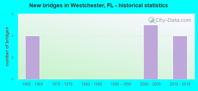
- New bridges - historical statistics
- 41960-1969
- 52000-2009
- 42010-2019


- Bridge Condition - Deck
- 50.0%Very good
- 25.0%Good
- 25.0%Satisfactory

- Bridge Condition - Superstructure
- 37.5%Very good
- 37.5%Good
- 25.0%Satisfactory

- Bridge Condition - Substructure
- 37.5%Very good
- 37.5%Good
- 25.0%Fair

- Bridge Condition - Channel
- 25.0%Good
- 75.0%Fair
Find on map >> Show street view
Structure Number: 87076, Location: 1 MI S OF US-41 (SR90) (Lat: 25.748114, Lng: -80.320075), Route carried "on" structure: State highway 826, Year Built: 2008, Status: Open, Structure Length: 4.57m (14.99ft), Average Daily Traffic: 91,250 (year 2020), Truck Traffic: 6%, Average Future Daily Traffic: 158,319 (year 2042), Design Load: HS 20, Features Intersected: SR-972 (SW 24TH ST)
Minimum Vertical Clearance: 30.45m (99.90ft), Kilometerpoint: 8.000, Lanes on structure: 7, Lanes under structure: 6, Base Highway Network: Yes, Owner: State Highway Agency, Approaching Roadway Width: 32.3m (106.0ft), Material/Design: Prestressed concrete, Design/Construction: Stringer/Multi-beam, Number Of Spans In Main Unit: 2, Length of Maximum Span: 22.9m (75.1ft), Curb-To-Curb Width: 32.3m (106.0ft), Out-to-Out Width: 33.2m (108.9ft)
Condition: Deck: Very good, Superstructure: Very good, Substructure: Very good, Inventory Rating: 58.9 metric tons, Method Used To Determine Inventory Rating: Load Factor (LF), Structural Evaluation: Equal to present desirable criteria, Deck Geometry: Better than present minimum criteria, Underclear: Equal to present minimum criteria, Approach Roadway Alignment: Equal to present desirable criteria, Designated Inspection Frequency: Every 24 months, Inspection Date: May 2020, Deck Structure Type: Concrete Cast-file-Place
Find on map >> Show street view
Structure Number: 870761, Location: 1 MI S OF US-41 (SR90) (Lat: 25.748128, Lng: -80.319783), Route carried "on" structure: State highway 826, Year Built: 2008, Status: Open, Structure Length: 4.57m (14.99ft), Average Daily Traffic: 91,250 (year 2020), Truck Traffic: 6%, Average Future Daily Traffic: 158,319 (year 2042), Design Load: HS 20, Features Intersected: SR-972 (SW 24TH ST)
Minimum Vertical Clearance: 30+ m (98+ ft), Kilometerpoint: 8.000, Lanes on structure: 7, Lanes under structure: 7, Base Highway Network: Yes, Owner: State Highway Agency, Approaching Roadway Width: 32.3m (106.0ft), Material/Design: Prestressed concrete, Design/Construction: Stringer/Multi-beam, Number Of Spans In Main Unit: 2, Length of Maximum Span: 22.9m (75.1ft), Curb-To-Curb Width: 32.3m (106.0ft), Out-to-Out Width: 33.2m (108.9ft)
Condition: Deck: Very good, Superstructure: Very good, Substructure: Very good, Inventory Rating: 58.9 metric tons, Method Used To Determine Inventory Rating: Load Factor (LF), Structural Evaluation: Equal to present desirable criteria, Deck Geometry: Better than present minimum criteria, Underclear: High priority of corrective action, Approach Roadway Alignment: Equal to present desirable criteria, Designated Inspection Frequency: Every 24 months, Inspection Date: May 2020, Deck Structure Type: Concrete Cast-file-Place
Find on map >> Show street view
Structure Number: 871021, Location: SW 40TH ST (Lat: 25.732956, Lng: -80.318697), Route carried "on" structure: State highway 826, Year Built: 2011, Status: Open, Structure Length: 4.89m (16.04ft), Average Daily Traffic: 72,000 (year 2021), Truck Traffic: 6%, Average Future Daily Traffic: 124,920 (year 2041), Design Load: HL 93, Features Intersected: SR-976 (BIRD ROAD)
Minimum Vertical Clearance: 30+ m (98+ ft), Kilometerpoint: 6.284, Lanes on structure: 6, Lanes under structure: 10, Base Highway Network: Yes, Owner: State Highway Agency, Approaching Roadway Width: 28.2m (92.5ft), Skew: 30 degrees, Material/Design: Prestressed concrete, Design/Construction: Stringer/Multi-beam, Number Of Spans In Main Unit: 1, Length of Maximum Span: 48.9m (160.4ft), Curb-To-Curb Width: 28.2m (92.5ft), Out-to-Out Width: 29.1m (95.5ft)
Condition: Deck: Very good, Superstructure: Very good, Substructure: Very good, Operating Rating: 45.1 metric tons, Method Used To Determine Operating Rating: Load and Resistance Factor (LRFR), Inventory Rating: 40.5 metric tons, Method Used To Determine Inventory Rating: Load and Resistance Factor (LRFR), Structural Evaluation: Equal to present desirable criteria, Deck Geometry: Equal to present minimum criteria, Underclear: Equal to present minimum criteria, Approach Roadway Alignment: Equal to present desirable criteria, Designated Inspection Frequency: Every 24 months, Inspection Date: October 2021, Deck Structure Type: Concrete Cast-file-Place
Find on map >> Show street view
Structure Number: 871022, Location: 2MI S OF US 41 (Lat: 25.732969, Lng: -80.318239), Route carried "on" structure: State highway 826, Year Built: 2011, Status: Open, Structure Length: 4.89m (16.04ft), Average Daily Traffic: 72,000 (year 2020), Truck Traffic: 6%, Average Future Daily Traffic: 124,920 (year 2042), Design Load: HL 93, Features Intersected: SW 40TH (BIRD ROAD)
Minimum Vertical Clearance: 30+ m (98+ ft), Kilometerpoint: 6.284, Lanes on structure: 7, Lanes under structure: 10, Base Highway Network: Yes, Owner: State Highway Agency, Approaching Roadway Width: 31.8m (104.3ft), Material/Design: Prestressed concrete, Design/Construction: Stringer/Multi-beam, Number Of Spans In Main Unit: 1, Length of Maximum Span: 48.9m (160.4ft), Curb-To-Curb Width: 31.8m (104.3ft), Out-to-Out Width: 32.7m (107.3ft)
Condition: Deck: Very good, Superstructure: Good, Substructure: Good, Operating Rating: 43.7 metric tons, Method Used To Determine Operating Rating: Load and Resistance Factor (LRFR), Inventory Rating: 39.2 metric tons, Method Used To Determine Inventory Rating: Load and Resistance Factor (LRFR), Structural Evaluation: Better than present minimum criteria, Deck Geometry: Equal to present minimum criteria, Underclear: Equal to present minimum criteria, Approach Roadway Alignment: Equal to present desirable criteria, Designated Inspection Frequency: Every 24 months, Inspection Date: April 2021, Deck Structure Type: Concrete Cast-file-Place
Find on map >> Show street view
Structure Number: 874243, Location: 0.1 miles S/O SW 24th St. (Lat: 25.746583, Lng: -80.317639), Route carried "on" structure: County highway , Year Built: 1960, Status: Open, Structure Length: 2.75m (9.02ft), Average Daily Traffic: 2,250 (year 2020), Truck Traffic: 3%, Average Future Daily Traffic: 4,133 (year 2042), Design Load: H 20, Features Intersected: Coral Gables Canal, Facility Carried by Structure: SW 75th Avenue
Minimum Vertical Clearance: 30.45m (99.90ft), Kilometerpoint: 0.048, Lanes on structure: 2, Owner: County Highway Agency, Approaching Roadway Width: 8.0m (26.2ft), Material/Design: Concrete, Design/Construction: Slab, Number Of Spans In Main Unit: 3, Length of Maximum Span: 9.2m (30.2ft), Curb or Sidewalk Widths: Left: 1.8m (5.9ft), Right: 1.9m (6.2ft), Curb-To-Curb Width: 8.6m (28.2ft), Out-to-Out Width: 12.3m (40.4ft)
Condition: Deck: Satisfactory, Superstructure: Satisfactory, Substructure: Good, Channel: Good, Operating Rating: 50.9 metric tons, Method Used To Determine Operating Rating: Load Factor (LF), Inventory Rating: 30.5 metric tons, Method Used To Determine Inventory Rating: Load Factor (LF), Structural Evaluation: Equal to present minimum criteria, Deck Geometry: Meets minimum limits, Waterway Adequacy: Better than present minimum criteria, Approach Roadway Alignment: Equal to present desirable criteria, Designated Inspection Frequency: Every 24 months, Underwater Inspection Frequency: Every 24 months, Inspection Date: August 2021, Underwater Inspection Date: August 2021, Deck Structure Type: Concrete Cast-file-Place, Wearing Surface/Protective System: Wearing Surface: Monolithic Concrete
Find on map >> Show street view
Structure Number: 874245, Location: 50Ft. E of SR826 Overpass (Lat: 25.748111, Lng: -80.319472), Route carried "on" structure: County highway , Year Built: 1960, Status: Open, Structure Length: 2.56m (8.40ft), Average Daily Traffic: 45,400 (year 2014), Truck Traffic: 5%, Average Future Daily Traffic: 81,071 (year 2036), Design Load: HS 20, Features Intersected: Coral Gables Canal, Facility Carried by Structure: SW 24th Street
Minimum Vertical Clearance: 30+ m (98+ ft), Kilometerpoint: 2.419, Lanes on structure: 4, Owner: County Highway Agency, Approaching Roadway Width: 35.7m (117.1ft), Skew: 20 degrees, Material/Design: Concrete, Design/Construction: Slab, Number Of Spans In Main Unit: 3, Length of Maximum Span: 8.5m (27.9ft), Curb or Sidewalk Widths: Left: 0.0m, Right: 2.0m (6.6ft), Curb-To-Curb Width: 25.4m (83.3ft), Out-to-Out Width: 34.1m (111.9ft)
Condition: Deck: Satisfactory, Superstructure: Satisfactory, Substructure: Good, Channel: Fair, Operating Rating: 53.3 metric tons, Method Used To Determine Operating Rating: Load Factor (LF), Inventory Rating: 32.0 metric tons, Method Used To Determine Inventory Rating: Load Factor (LF), Structural Evaluation: Equal to present minimum criteria, Deck Geometry: Superior to present desirable criteria, Waterway Adequacy: Equal to present minimum criteria, Approach Roadway Alignment: Equal to present desirable criteria, Designated Inspection Frequency: Every 24 months, Underwater Inspection Frequency: Every 24 months, Inspection Date: Febuary 2020, Underwater Inspection Date: Febuary 2020, Deck Structure Type: Concrete Cast-file-Place, Wearing Surface/Protective System: Wearing Surface: Monolithic Concrete, Membrane: Built-up
Find on map >> Show street view
Structure Number: 874398, Location: 0.2 Miles E of SW 97th Av (Lat: 25.758250, Lng: -80.347500), Route carried "on" structure: County highway , Year Built: 1960, Status: Open, Structure Length: 0.76m (2.49ft), Average Daily Traffic: 604 (year 2021), Truck Traffic: 5%, Average Future Daily Traffic: 973 (year 2042), Design Load: HL 93, Features Intersected: Coral Park Canal, Facility Carried by Structure: SW 12th Street
Minimum Vertical Clearance: 30.45m (99.90ft), Kilometerpoint: 0.459, Lanes on structure: 2, Owner: County Highway Agency, Approaching Roadway Width: 6.4m (21.0ft), Material/Design: Prestressed concrete, Design/Construction: Slab, Number Of Spans In Main Unit: 1, Length of Maximum Span: 7.6m (24.9ft), Curb or Sidewalk Widths: Left: 1.2m (3.9ft), Right: 1.2m (3.9ft), Curb-To-Curb Width: 8.0m (26.2ft), Out-to-Out Width: 11.2m (36.7ft)
Condition: Deck: Good, Superstructure: Good, Substructure: Fair, Channel: Fair, Operating Rating: 87.8 metric tons, Method Used To Determine Operating Rating: Load and Resistance Factor (LRFR), Inventory Rating: 67.8 metric tons, Method Used To Determine Inventory Rating: Load and Resistance Factor (LRFR), Structural Evaluation: Somewhat better than minimum adequacy, Deck Geometry: Somewhat better than minimum adequacy, Waterway Adequacy: Better than present minimum criteria, Approach Roadway Alignment: Equal to present desirable criteria, Designated Inspection Frequency: Every 24 months, Inspection Date: August 2021, Deck Structure Type: Concrete Precast Panels, Wearing Surface/Protective System: Wearing Surface: Bituminous
Find on map >> Show street view
Structure Number: 874399, Location: 250 ft. N/O SW 16th St. (Lat: 25.755194, Lng: -80.343944), Route carried "on" structure: County highway , Year Built: 1960, Status: Open, Structure Length: 0.62m (2.03ft), Average Daily Traffic: 13,104 (year 2021), Truck Traffic: 1%, Average Future Daily Traffic: 23,727 (year 2042), Design Load: HS 20, Features Intersected: Coral Park Canal, Facility Carried by Structure: SW 92nd Avenue
Minimum Vertical Clearance: 30+ m (98+ ft), Kilometerpoint: 2.483, Lanes on structure: 2, Owner: County Highway Agency, Approaching Roadway Width: 5.9m (19.4ft), Material/Design: Prestressed concrete, Design/Construction: Slab, Number Of Spans In Main Unit: 1, Length of Maximum Span: 6.2m (20.3ft), Curb or Sidewalk Widths: Left: 1.2m (3.9ft), Right: 1.2m (3.9ft), Curb-To-Curb Width: 8.7m (28.5ft), Out-to-Out Width: 11.8m (38.7ft)
Condition: Deck: Good, Superstructure: Good, Substructure: Fair, Channel: Fair, Operating Rating: 77.7 metric tons, Method Used To Determine Operating Rating: Load Factor (LF), Inventory Rating: 46.5 metric tons, Method Used To Determine Inventory Rating: Load Factor (LF), Structural Evaluation: Somewhat better than minimum adequacy, Deck Geometry: High priority of replacement, Waterway Adequacy: Better than present minimum criteria, Approach Roadway Alignment: Equal to present desirable criteria, Designated Inspection Frequency: Every 24 months, Inspection Date: August 2021, Deck Structure Type: Concrete Precast Panels, Wearing Surface/Protective System: Wearing Surface: Bituminous
Find on map >> Show street view
Structure Number: 87076, Location: 1 MI S OF US-41 (SR90) (Lat: 25.748114, Lng: -80.320075), Route carried "under" structure: State highway 972, Year Built: 2008, Structure Length: 0. m, Average Daily Traffic: 46,000 (year 2020), Truck Traffic: 4%, Features Intersected: SR-972 (SW 24TH ST), Facility Carried by Structure: SR-826 SB
Minimum Vertical Clearance: 5.03m (16.50ft), Kilometerpoint: 2.361, Lanes on structure: 7, Lanes under structure: 6, Material/Design: Prestressed concrete, Design/Construction: Stringer/Multi-beam, Length of Maximum Span: 22.9m (75.1ft)
Find on map >> Show street view
Structure Number: 870761, Location: 1 MI S OF US-41 (SR90) (Lat: 25.748128, Lng: -80.319783), Route carried "under" structure: State highway 972, Year Built: 2008, Structure Length: 0. m, Average Daily Traffic: 46,000 (year 2020), Truck Traffic: 4%, Features Intersected: SR-972 (SW 24TH ST), Facility Carried by Structure: SR-826 NB
Minimum Vertical Clearance: 5.03m (16.50ft), Kilometerpoint: 2.383, Lanes on structure: 7, Lanes under structure: 7, Material/Design: Prestressed concrete, Design/Construction: Stringer/Multi-beam, Length of Maximum Span: 22.9m (75.1ft)
Find on map >> Show street view
Structure Number: 871021, Location: SW 40TH ST (Lat: 25.732956, Lng: -80.318697), Route carried "under" structure: State highway 976, Year Built: 2011, Structure Length: 0. m, Average Daily Traffic: 64,000 (year 2021), Truck Traffic: 6%, Features Intersected: SR-976 (BIRD ROAD), Facility Carried by Structure: SR-826 SB (871022)
Minimum Vertical Clearance: 5.09m (16.70ft), Kilometerpoint: 6.754, Lanes on structure: 6, Lanes under structure: 10, Material/Design: Prestressed concrete, Design/Construction: Stringer/Multi-beam, Length of Maximum Span: 48.9m (160.4ft)
Find on map >> Show street view
Structure Number: 871022, Location: 2MI S OF US 41 (Lat: 25.732969, Lng: -80.318239), Route carried "under" structure: State highway 976, Year Built: 2011, Structure Length: 0. m, Average Daily Traffic: 64,000 (year 2020), Truck Traffic: 6%, Features Intersected: SW 40TH (BIRD ROAD), Facility Carried by Structure: NB SR 826 PALMETTO
Minimum Vertical Clearance: 4.97m (16.31ft), Kilometerpoint: 6.785, Lanes on structure: 7, Lanes under structure: 10, Material/Design: Prestressed concrete, Design/Construction: Stringer/Multi-beam, Length of Maximum Span: 48.9m (160.4ft)
Find on map >> Show street view
Structure Number: 87901, Location: SR-826 Ramps to Coral Way (Lat: 25.748419, Lng: -80.321167), Route carried "under" structure: Ramp State highway 826, Year Built: 2008, Structure Length: 0. m, Average Daily Traffic: 38,400 (year 2018), Truck Traffic: 10%, Features Intersected: SR826SB TO/FROM SW 24ST, Facility Carried by Structure: PEDESTRN OVERPASS
Minimum Vertical Clearance: 5.46m (17.91ft), Kilometerpoint: 7.957, Lanes under structure: 5, Material/Design: Prestressed concrete, Design/Construction: Stringer/Multi-beam, Length of Maximum Span: 36.9m (121.1ft)