Bridge Statistics for Wesley Chapel, Florida (FL)
Condition, Traffic, Stress, Structural Evaluation, Project Costs
- National Bridge Inventory (NBI) Statistics
- 41Number of bridges
- 394ft / 120mTotal length
- 1,251,980Total average daily traffic
- 139,571Total average daily truck traffic
- National Bridge Inventory (NBI) Registered Bridges for Wesley Chapel
- No street view available for this location
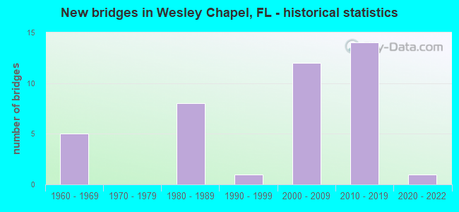
- New bridges - historical statistics
- 51960-1969
- 81980-1989
- 11990-1999
- 122000-2009
- 142010-2019
- 12020-2022

- Reconstructed bridges - Historical Statistics
- 11970-1979
- 01980-1989
- 11990-1999
- 42000-2009
- 12010-2019


- Bridge Condition - Deck
- 16.7%Very good
- 83.3%Good

- Bridge Condition - Superstructure
- 5.6%Excellent
- 27.8%Very good
- 66.7%Good

- Bridge Condition - Substructure
- 33.3%Very good
- 55.6%Good
- 11.1%Satisfactory

- Bridge Condition - Channel
- 3.4%Excellent
- 31.0%Very good
- 48.3%Good
- 17.2%Satisfactory

- Bridge Condition - Culverts
- 12.5%Very good
- 75.0%Good
- 12.5%Satisfactory
Find on map >> Show street view
Structure Number: 100492, Location: 2.5MI W OF CR-581 (Lat: 28.171250, Lng: -82.394283), Route carried "on" structure: County highway , Year Built: 1985, Status: Open, Structure Length: 14.20m (46.59ft), Average Daily Traffic: 15,500 (year 2020), Truck Traffic: 9%, Average Future Daily Traffic: 26,892 (year 2042), Design Load: HS 20, Features Intersected: I-75 & I-275 SB, Facility Carried by Structure: COUNTYLINE ROAD
Minimum Vertical Clearance: 30+ m (98+ ft), Kilometerpoint: 3.272, Lanes on structure: 2, Lanes under structure: 10, Owner: State Highway Agency, Approaching Roadway Width: 12.2m (40.0ft), Material/Design: Prestressed concrete, Design/Construction: Stringer/Multi-beam, Number Of Spans In Main Unit: 6, Length of Maximum Span: 31.4m (103.0ft), Curb-To-Curb Width: 12.2m (40.0ft), Out-to-Out Width: 13.1m (43.0ft)
Condition: Deck: Good, Superstructure: Good, Substructure: Good, Operating Rating: 51.7 metric tons, Method Used To Determine Operating Rating: Allowable Stress (AS), Inventory Rating: 41.7 metric tons, Method Used To Determine Inventory Rating: Allowable Stress (AS), Structural Evaluation: Better than present minimum criteria, Deck Geometry: Somewhat better than minimum adequacy, Underclear: Meets minimum limits, Approach Roadway Alignment: Equal to present desirable criteria, Designated Inspection Frequency: Every 24 months, Inspection Date: November 2021, Deck Structure Type: Concrete Cast-file-Place
Find on map >> Show street view
Structure Number: 100493, Location: 2.5 MILES W OF CR-581 (Lat: 28.171242, Lng: -82.392361), Route carried "on" structure: County highway , Year Built: 1985, Status: Open, Structure Length: 4.82m (15.81ft), Average Daily Traffic: 15,500 (year 2020), Truck Traffic: 9%, Average Future Daily Traffic: 26,892 (year 2042), Design Load: HS 20, Features Intersected: I 275 NB, Facility Carried by Structure: COUNTY LINE RD
Minimum Vertical Clearance: 30+ m (98+ ft), Kilometerpoint: 3.499, Lanes on structure: 2, Lanes under structure: 4, Owner: State Highway Agency, Approaching Roadway Width: 12.2m (40.0ft), Material/Design: Prestressed concrete, Design/Construction: Stringer/Multi-beam, Number Of Spans In Main Unit: 3, Length of Maximum Span: 26.8m (87.9ft), Curb-To-Curb Width: 12.2m (40.0ft), Out-to-Out Width: 13.1m (43.0ft)
Condition: Deck: Good, Superstructure: Good, Substructure: Good, Operating Rating: 49.9 metric tons, Method Used To Determine Operating Rating: Allowable Stress (AS), Inventory Rating: 36.3 metric tons, Method Used To Determine Inventory Rating: Allowable Stress (AS), Structural Evaluation: Better than present minimum criteria, Deck Geometry: Somewhat better than minimum adequacy, Underclear: Meets minimum limits, Approach Roadway Alignment: Equal to present desirable criteria, Designated Inspection Frequency: Every 24 months, Inspection Date: September 2021, Deck Structure Type: Concrete Cast-file-Place
Find on map >> Show street view
Structure Number: 104131, Location: 1.2 MI W OF CR-581 (Lat: 28.171239, Lng: -82.388592), Route carried "on" structure: County highway , Year Built: 1985, Status: Open, Structure Length: 4.88m (16.01ft), Average Daily Traffic: 5,560 (year 2021), Truck Traffic: 5%, Average Future Daily Traffic: 6,950 (year 2041), Features Intersected: CYPRESS CREEK, Facility Carried by Structure: COUNTY LINE ROAD
Minimum Vertical Clearance: 30+ m (98+ ft), Kilometerpoint: 3.869, Lanes on structure: 2, Owner: County Highway Agency, Approaching Roadway Width: 7.3m (24.0ft), Skew: 2 degrees, Material/Design: Prestressed concrete, Design/Construction: Stringer/Multi-beam, Number Of Spans In Main Unit: 3, Length of Maximum Span: 16.3m (53.5ft), Curb-To-Curb Width: 12.2m (40.0ft), Out-to-Out Width: 13.2m (43.3ft)
Condition: Deck: Good, Superstructure: Good, Substructure: Good, Channel: Good, Operating Rating: 50.5 metric tons, Method Used To Determine Operating Rating: Allowable Stress (AS), Inventory Rating: 45.6 metric tons, Method Used To Determine Inventory Rating: Allowable Stress (AS), Structural Evaluation: Better than present minimum criteria, Deck Geometry: Somewhat better than minimum adequacy, Waterway Adequacy: Superior to present desirable criteria, Approach Roadway Alignment: Equal to present desirable criteria, Designated Inspection Frequency: Every 24 months, Inspection Date: April 2021, Deck Structure Type: Concrete Cast-file-Place
Find on map >> Show street view
Structure Number: 104132, Location: 0.5 MI WEST OF CR-581 (Lat: 28.171278, Lng: -82.362167), Route carried "on" structure: County highway , Year Built: 1985, Status: Open, Structure Length: 5.19m (17.03ft), Average Daily Traffic: 5,560 (year 2021), Truck Traffic: 5%, Average Future Daily Traffic: 6,950 (year 2041), Features Intersected: TROUT CREEK, Facility Carried by Structure: COUNTY LINE ROAD
Minimum Vertical Clearance: 30+ m (98+ ft), Kilometerpoint: 6.486, Lanes on structure: 2, Owner: County Highway Agency, Approaching Roadway Width: 7.3m (24.0ft), Skew: 2 degrees, Material/Design: Prestressed concrete, Design/Construction: Stringer/Multi-beam, Number Of Spans In Main Unit: 3, Length of Maximum Span: 17.4m (57.1ft), Curb-To-Curb Width: 12.2m (40.0ft), Out-to-Out Width: 13.2m (43.3ft)
Condition: Deck: Good, Superstructure: Very good, Substructure: Good, Channel: Good, Operating Rating: 52.9 metric tons, Method Used To Determine Operating Rating: Allowable Stress (AS), Inventory Rating: 47.5 metric tons, Method Used To Determine Inventory Rating: Allowable Stress (AS), Structural Evaluation: Better than present minimum criteria, Deck Geometry: Somewhat better than minimum adequacy, Waterway Adequacy: Superior to present desirable criteria, Approach Roadway Alignment: Equal to present desirable criteria, Designated Inspection Frequency: Every 24 months, Inspection Date: April 2021, Deck Structure Type: Concrete Cast-file-Place
Find on map >> Show street view
Structure Number: 140013, Location: 2.9 MILES WEST OF I-75 (Lat: 28.214119, Lng: -82.390697), Route carried "on" structure: County highway 54, Year Built: 1963, Year Reconstructed: 1995, Status: Open, Structure Length: 1.41m (4.63ft), Average Daily Traffic: 59,500 (year 2021), Truck Traffic: 10%, Average Future Daily Traffic: 103,233 (year 2041), Design Load: HS 20, Features Intersected: CABBAGE SWAMP SLOUGH
Minimum Vertical Clearance: 30+ m (98+ ft), Kilometerpoint: 9.704, Lanes on structure: 2, Owner: County Highway Agency, Approaching Roadway Width: 10.2m (33.5ft), Material/Design: Concrete, Design/Construction: Culvert, Number Of Spans In Main Unit: 4, Length of Maximum Span: 3.6m (11.8ft)
Condition: Channel: Good, Culverts: Satisfactory, Inventory Rating: 57.2 metric tons, Method Used To Determine Inventory Rating: Load Factor (LF), Structural Evaluation: Equal to present minimum criteria, Waterway Adequacy: Better than present minimum criteria, Approach Roadway Alignment: Equal to present desirable criteria, Designated Inspection Frequency: Every 24 months, Inspection Date: Febuary 2021
Find on map >> Show street view
Structure Number: 140047, Location: 0.5MI N OF SR-56 (Lat: 28.200747, Lng: -82.380472), Route carried "on" structure: Interstate 75, Year Built: 1965, Year Reconstructed: 2000, Status: Open, Structure Length: 1.19m (3.90ft), Average Daily Traffic: 101,550 (year 2021), Truck Traffic: 14%, Average Future Daily Traffic: 176,189 (year 2041), Design Load: HS 20+Mod, Features Intersected: CABBAGE SWAMP CREEK
Minimum Vertical Clearance: 30+ m (98+ ft), Kilometerpoint: 3.475, Lanes on structure: 8, Base Highway Network: Yes, Owner: State Highway Agency, Approaching Roadway Width: 30.4m (99.7ft), Skew: 30 degrees, Material/Design: Concrete, Design/Construction: Culvert, Number Of Spans In Main Unit: 3, Length of Maximum Span: 3.8m (12.5ft)
Condition: Channel: Satisfactory, Culverts: Satisfactory, Inventory Rating: 57.0 metric tons, Method Used To Determine Inventory Rating: Load Factor (LF), Structural Evaluation: Equal to present minimum criteria, Waterway Adequacy: Equal to present desirable criteria, Approach Roadway Alignment: Equal to present desirable criteria, Designated Inspection Frequency: Every 24 months, Inspection Date: January 2021
Find on map >> Show street view
Structure Number: 140053, Location: 2.5 MI SOUTH OF US-52 (Lat: 28.290417, Lng: -82.325583), Route carried "on" structure: Interstate 75, Year Built: 1965, Year Reconstructed: 2017, Status: Open, Structure Length: 1.00m (3.28ft), Average Daily Traffic: 68,000 (year 2021), Truck Traffic: 14%, Average Future Daily Traffic: 117,980 (year 2041), Design Load: HS 20+Mod, Features Intersected: SCAPEGOAT BRANCH
Minimum Vertical Clearance: 30+ m (98+ ft), Kilometerpoint: 15.055, Lanes on structure: 6, Base Highway Network: Yes, Owner: State Highway Agency, Approaching Roadway Width: 44.0m (144.4ft), Skew: 13 degrees, Material/Design: Concrete, Design/Construction: Culvert, Number Of Spans In Main Unit: 3, Length of Maximum Span: 2.9m (9.5ft)
Condition: Channel: Good, Culverts: Good, Structural Evaluation: Better than present minimum criteria, Waterway Adequacy: Better than present minimum criteria, Approach Roadway Alignment: Equal to present desirable criteria, Designated Inspection Frequency: Every 24 months, Inspection Date: January 2021
Find on map >> Show street view
Structure Number: 140061, Location: 0.8MI S OF SR-56 (Lat: 28.182383, Lng: -82.389358), Route carried "on" structure: Interstate 75, Year Built: 1963, Year Reconstructed: 2007, Status: Open, Structure Length: 4.78m (15.68ft), Average Daily Traffic: 54,500 (year 2021), Truck Traffic: 14%, Average Future Daily Traffic: 94,558 (year 2041), Design Load: HS 20+Mod, Features Intersected: CYPRESS CREEK
Minimum Vertical Clearance: 30+ m (98+ ft), Kilometerpoint: 1.239, Lanes on structure: 6, Base Highway Network: Yes, Owner: State Highway Agency, Approaching Roadway Width: 28.3m (92.8ft), Skew: 2 degrees, Material/Design: Prestressed concrete, Design/Construction: Stringer/Multi-beam, Number Of Spans In Main Unit: 3, Length of Maximum Span: 16.1m (52.8ft), Curb-To-Curb Width: 28.3m (92.8ft), Out-to-Out Width: 29.5m (96.8ft)
Condition: Deck: Good, Superstructure: Good, Substructure: Satisfactory, Channel: Satisfactory, Operating Rating: 53.5 metric tons, Method Used To Determine Operating Rating: Load and Resistance Factor (LRFR), Inventory Rating: 41.5 metric tons, Method Used To Determine Inventory Rating: Load and Resistance Factor (LRFR), Structural Evaluation: Equal to present minimum criteria, Deck Geometry: Better than present minimum criteria, Waterway Adequacy: Equal to present desirable criteria, Approach Roadway Alignment: Equal to present desirable criteria, Designated Inspection Frequency: Every 24 months, Underwater Inspection Frequency: Every 24 months, Inspection Date: January 2021, Underwater Inspection Date: December 2020, Deck Structure Type: Concrete Cast-file-Place
Find on map >> Show street view
Structure Number: 140062, Location: 0.8MI S OF SR-56 (Lat: 28.182389, Lng: -82.388936), Route carried "on" structure: Interstate 75, Year Built: 1963, Year Reconstructed: 1983, Status: Open, Structure Length: 4.77m (15.65ft), Average Daily Traffic: 54,500 (year 2021), Truck Traffic: 14%, Average Future Daily Traffic: 94,558 (year 2041), Design Load: HS 20+Mod, Features Intersected: CYPRESS CREEK
Minimum Vertical Clearance: 30+ m (98+ ft), Kilometerpoint: 1.259, Lanes on structure: 4, Base Highway Network: Yes, Owner: State Highway Agency, Approaching Roadway Width: 20.8m (68.2ft), Skew: 2 degrees, Material/Design: Prestressed concrete, Design/Construction: Stringer/Multi-beam, Number Of Spans In Main Unit: 3, Length of Maximum Span: 16.1m (52.8ft), Curb-To-Curb Width: 20.8m (68.2ft), Out-to-Out Width: 21.6m (70.9ft)
Condition: Deck: Good, Superstructure: Good, Substructure: Satisfactory, Channel: Satisfactory, Operating Rating: 49.1 metric tons, Method Used To Determine Operating Rating: Load Factor (LF), Inventory Rating: 29.0 metric tons, Method Used To Determine Inventory Rating: Load Factor (LF), Structural Evaluation: Equal to present minimum criteria, Deck Geometry: Equal to present minimum criteria, Waterway Adequacy: Equal to present desirable criteria, Approach Roadway Alignment: Equal to present desirable criteria, Designated Inspection Frequency: Every 24 months, Underwater Inspection Frequency: Every 24 months, Inspection Date: January 2021, Underwater Inspection Date: December 2020, Deck Structure Type: Concrete Cast-file-Place
Find on map >> Show street view
Structure Number: 14012, Location: 0.25 MILE WEST OF SR-56 (Lat: 28.187056, Lng: -82.402222), Route carried "on" structure: State highway 54, Year Built: 2001, Year Reconstructed: 2008, Status: Open, Structure Length: 4.12m (13.52ft), Average Daily Traffic: 38,000 (year 2021), Truck Traffic: 6%, Average Future Daily Traffic: 65,930 (year 2041), Design Load: HS 20, Features Intersected: CYPRESS CREEK
Minimum Vertical Clearance: 30+ m (98+ ft), Kilometerpoint: 0.558, Lanes on structure: 4, Base Highway Network: Yes, Owner: State Highway Agency, Approaching Roadway Width: 12.7m (41.7ft), Material/Design: Prestressed concrete, Design/Construction: Stringer/Multi-beam, Number Of Spans In Main Unit: 2, Length of Maximum Span: 20.6m (67.6ft), Curb or Sidewalk Widths: Left: 1.6m (5.2ft), Right: 0.0m, Curb-To-Curb Width: 19.6m (64.3ft), Out-to-Out Width: 22.3m (73.2ft)
Condition: Deck: Good, Superstructure: Very good, Substructure: Good, Channel: Good, Operating Rating: 56.5 metric tons, Method Used To Determine Operating Rating: Load and Resistance Factor (LRFR), Inventory Rating: 40.2 metric tons, Method Used To Determine Inventory Rating: Load and Resistance Factor (LRFR), Structural Evaluation: Better than present minimum criteria, Deck Geometry: Better than present minimum criteria, Waterway Adequacy: Superior to present desirable criteria, Approach Roadway Alignment: Equal to present desirable criteria, Designated Inspection Frequency: Every 24 months, Underwater Inspection Frequency: Every 24 months, Inspection Date: Febuary 2021, Underwater Inspection Date: January 2021, Deck Structure Type: Concrete Cast-file-Place
Find on map >> Show street view
Structure Number: 140121, Location: 1.5 MILES EAST OF I-75 (Lat: 28.185722, Lng: -82.363389), Route carried "on" structure: State highway 56, Year Built: 2002, Status: Open, Structure Length: 6.10m (20.01ft), Average Daily Traffic: 29,750 (year 2021), Truck Traffic: 4%, Average Future Daily Traffic: 51,616 (year 2041), Design Load: HS 20, Features Intersected: CABBAGE SWAMP
Minimum Vertical Clearance: 30+ m (98+ ft), Kilometerpoint: 4.979, Lanes on structure: 3, Base Highway Network: Yes, Owner: State Highway Agency, Approaching Roadway Width: 15.1m (49.5ft), Skew: 3 degrees, Material/Design: Prestressed concrete, Design/Construction: Stringer/Multi-beam, Number Of Spans In Main Unit: 2, Length of Maximum Span: 30.5m (100.1ft), Curb or Sidewalk Widths: Left: 1.5m (4.9ft), Right: 0.0m, Curb-To-Curb Width: 15.1m (49.5ft), Out-to-Out Width: 18.0m (59.1ft)
Condition: Deck: Good, Superstructure: Good, Substructure: Very good, Channel: Good, Operating Rating: 80.7 metric tons, Method Used To Determine Operating Rating: Load Factor (LF), Inventory Rating: 49.9 metric tons, Method Used To Determine Inventory Rating: Load Factor (LF), Structural Evaluation: Better than present minimum criteria, Deck Geometry: Equal to present minimum criteria, Waterway Adequacy: Superior to present desirable criteria, Approach Roadway Alignment: Equal to present desirable criteria, Designated Inspection Frequency: Every 24 months, Inspection Date: Febuary 2021, Deck Structure Type: Concrete Cast-file-Place
Find on map >> Show street view
Structure Number: 140122, Location: 1.5 MILES EAST OF I-75 (Lat: 28.185500, Lng: -82.363250), Route carried "on" structure: State highway 56, Year Built: 2002, Status: Open, Structure Length: 6.10m (20.01ft), Average Daily Traffic: 29,750 (year 2021), Truck Traffic: 4%, Average Future Daily Traffic: 51,616 (year 2041), Design Load: HS 20, Features Intersected: CABBAGE SWAMP
Minimum Vertical Clearance: 30+ m (98+ ft), Kilometerpoint: 4.995, Lanes on structure: 3, Base Highway Network: Yes, Owner: State Highway Agency, Approaching Roadway Width: 15.1m (49.5ft), Skew: 3 degrees, Material/Design: Prestressed concrete, Design/Construction: Stringer/Multi-beam, Number Of Spans In Main Unit: 2, Length of Maximum Span: 30.5m (100.1ft), Curb or Sidewalk Widths: Left: 0.0m, Right: 1.5m (4.9ft), Curb-To-Curb Width: 15.1m (49.5ft), Out-to-Out Width: 18.0m (59.1ft)
Condition: Deck: Good, Superstructure: Good, Substructure: Good, Channel: Good, Operating Rating: 80.7 metric tons, Method Used To Determine Operating Rating: Load Factor (LF), Inventory Rating: 49.9 metric tons, Method Used To Determine Inventory Rating: Load Factor (LF), Structural Evaluation: Better than present minimum criteria, Deck Geometry: Equal to present minimum criteria, Waterway Adequacy: Superior to present desirable criteria, Approach Roadway Alignment: Equal to present desirable criteria, Designated Inspection Frequency: Every 24 months, Inspection Date: Febuary 2021, Deck Structure Type: Concrete Cast-file-Place
Find on map >> Show street view
Structure Number: 140123, Location: 2.0 MILES EAST OF I-75 (Lat: 28.185889, Lng: -82.355833), Route carried "on" structure: State highway 56, Year Built: 2002, Status: Open, Structure Length: 4.15m (13.62ft), Average Daily Traffic: 29,750 (year 2021), Truck Traffic: 4%, Average Future Daily Traffic: 51,616 (year 2041), Design Load: HS 20, Features Intersected: TROUT CREEK
Minimum Vertical Clearance: 30+ m (98+ ft), Kilometerpoint: 5.739, Lanes on structure: 3, Base Highway Network: Yes, Owner: State Highway Agency, Approaching Roadway Width: 17.3m (56.8ft), Skew: 3 degrees, Material/Design: Prestressed concrete, Design/Construction: Stringer/Multi-beam, Number Of Spans In Main Unit: 2, Length of Maximum Span: 20.7m (67.9ft), Curb-To-Curb Width: 17.2m (56.4ft), Out-to-Out Width: 18.0m (59.1ft)
Condition: Deck: Very good, Superstructure: Very good, Substructure: Good, Channel: Good, Operating Rating: 78.9 metric tons, Method Used To Determine Operating Rating: Load Factor (LF), Inventory Rating: 47.2 metric tons, Method Used To Determine Inventory Rating: Load Factor (LF), Structural Evaluation: Better than present minimum criteria, Deck Geometry: Superior to present desirable criteria, Waterway Adequacy: Superior to present desirable criteria, Approach Roadway Alignment: Equal to present desirable criteria, Designated Inspection Frequency: Every 24 months, Inspection Date: Febuary 2021, Deck Structure Type: Concrete Cast-file-Place
Find on map >> Show street view
Structure Number: 140124, Location: 2.0 MILES EAST OF I-75 (Lat: 28.185639, Lng: -82.356000), Route carried "on" structure: State highway 56, Year Built: 2002, Status: Open, Structure Length: 4.15m (13.62ft), Average Daily Traffic: 29,750 (year 2021), Truck Traffic: 4%, Average Future Daily Traffic: 51,616 (year 2041), Design Load: HS 20, Features Intersected: TROUT CREEK
Minimum Vertical Clearance: 30+ m (98+ ft), Kilometerpoint: 5.723, Lanes on structure: 5, Base Highway Network: Yes, Owner: State Highway Agency, Approaching Roadway Width: 22.4m (73.5ft), Skew: 3 degrees, Material/Design: Prestressed concrete, Design/Construction: Stringer/Multi-beam, Number Of Spans In Main Unit: 2, Length of Maximum Span: 20.7m (67.9ft), Curb or Sidewalk Widths: Left: 0.0m, Right: 1.5m (4.9ft), Curb-To-Curb Width: 22.4m (73.5ft), Out-to-Out Width: 25.3m (83.0ft)
Condition: Deck: Good, Superstructure: Good, Substructure: Very good, Channel: Satisfactory, Operating Rating: 71.7 metric tons, Method Used To Determine Operating Rating: Load Factor (LF), Inventory Rating: 42.6 metric tons, Method Used To Determine Inventory Rating: Load Factor (LF), Structural Evaluation: Better than present minimum criteria, Deck Geometry: Equal to present minimum criteria, Waterway Adequacy: Superior to present desirable criteria, Approach Roadway Alignment: Equal to present desirable criteria, Designated Inspection Frequency: Every 24 months, Inspection Date: Febuary 2021, Deck Structure Type: Concrete Cast-file-Place
Find on map >> Show street view
Structure Number: 140125, Location: 1.6 MI N/O COUNTY LINE RO (Lat: 28.194197, Lng: -82.384117), Route carried "on" structure: State highway 56, Year Built: 2002, Status: Open, Structure Length: 9.80m (32.15ft), Average Daily Traffic: 59,500 (year 2021), Truck Traffic: 4%, Average Future Daily Traffic: 103,232 (year 2041), Design Load: HS 20+Mod, Features Intersected: I-75 (SR-93)
Minimum Vertical Clearance: 5.49m (18.01ft), Kilometerpoint: 2.597, Lanes on structure: 7, Lanes under structure: 8, Base Highway Network: Yes, Owner: State Highway Agency, Approaching Roadway Width: 38.1m (125.0ft), Skew: 20 degrees, Material/Design: Prestressed concrete, Design/Construction: Stringer/Multi-beam, Number Of Spans In Main Unit: 2, Length of Maximum Span: 49.0m (160.8ft), Curb-To-Curb Width: 36.3m (119.1ft), Out-to-Out Width: 40.9m (134.2ft)
Condition: Deck: Good, Superstructure: Good, Substructure: Good, Operating Rating: 89.3 metric tons, Method Used To Determine Operating Rating: Load Factor (LF), Inventory Rating: 53.5 metric tons, Method Used To Determine Inventory Rating: Load Factor (LF), Structural Evaluation: Better than present minimum criteria, Deck Geometry: Superior to present desirable criteria, Underclear: Better than present minimum criteria, Approach Roadway Alignment: Equal to present desirable criteria, Designated Inspection Frequency: Every 24 months, Inspection Date: January 2021, Deck Structure Type: Concrete Cast-file-Place
Find on map >> Show street view
Structure Number: 140126, Location: 0.25 MILE WEST OF SR-56 (Lat: 28.186889, Lng: -82.402083), Route carried "on" structure: State highway 54, Year Built: 2002, Year Reconstructed: 2008, Status: Open, Structure Length: 4.11m (13.48ft), Average Daily Traffic: 38,000 (year 2021), Truck Traffic: 6%, Average Future Daily Traffic: 65,930 (year 2041), Design Load: HS 20, Features Intersected: CYPRESS CREEK
Minimum Vertical Clearance: 30+ m (98+ ft), Kilometerpoint: 0.558, Lanes on structure: 3, Base Highway Network: Yes, Owner: State Highway Agency, Approaching Roadway Width: 12.7m (41.7ft), Material/Design: Prestressed concrete, Design/Construction: Stringer/Multi-beam, Number Of Spans In Main Unit: 2, Length of Maximum Span: 20.6m (67.6ft), Curb or Sidewalk Widths: Left: 0.0m, Right: 1.6m (5.2ft), Curb-To-Curb Width: 15.9m (52.2ft), Out-to-Out Width: 18.5m (60.7ft)
Condition: Deck: Good, Superstructure: Good, Substructure: Good, Channel: Good, Operating Rating: 44.5 metric tons, Method Used To Determine Operating Rating: Load and Resistance Factor (LRFR), Inventory Rating: 33.3 metric tons, Method Used To Determine Inventory Rating: Load and Resistance Factor (LRFR), Structural Evaluation: Better than present minimum criteria, Deck Geometry: Better than present minimum criteria, Waterway Adequacy: Equal to present desirable criteria, Approach Roadway Alignment: Equal to present desirable criteria, Designated Inspection Frequency: Every 24 months, Underwater Inspection Frequency: Every 24 months, Inspection Date: Febuary 2021, Underwater Inspection Date: January 2021, Deck Structure Type: Concrete Cast-file-Place
Find on map >> Show street view
Structure Number: 140129, Location: 3.5 MI NORTH OF SR-56 (Lat: 28.236922, Lng: -82.354647), Route carried "on" structure: Interstate 75, Year Built: 2010, Status: Open, Structure Length: 5.93m (19.46ft), Average Daily Traffic: 34,000 (year 2021), Truck Traffic: 14%, Average Future Daily Traffic: 58,990 (year 2041), Design Load: HL 93, Features Intersected: SR-54
Minimum Vertical Clearance: 30+ m (98+ ft), Kilometerpoint: 8.184, Lanes on structure: 3, Lanes under structure: 9, Base Highway Network: Yes, Owner: State Highway Agency, Approaching Roadway Width: 16.9m (55.4ft), Skew: 2 degrees, Material/Design: Steel, Design/Construction: Stringer/Multi-beam, Number Of Spans In Main Unit: 1, Length of Maximum Span: 59.3m (194.6ft), Curb-To-Curb Width: 17.1m (56.1ft), Out-to-Out Width: 18.0m (59.1ft)
Condition: Deck: Good, Superstructure: Very good, Substructure: Very good, Operating Rating: 66.0 metric tons, Method Used To Determine Operating Rating: Load and Resistance Factor (LRFR), Inventory Rating: 51.0 metric tons, Method Used To Determine Inventory Rating: Load and Resistance Factor (LRFR), Structural Evaluation: Equal to present desirable criteria, Deck Geometry: Equal to present minimum criteria, Underclear: Superior to present desirable criteria, Approach Roadway Alignment: Equal to present desirable criteria, Designated Inspection Frequency: Every 24 months, Inspection Date: January 2021, Deck Structure Type: Concrete Cast-file-Place
Find on map >> Show street view
Structure Number: 14013, Location: 3.5 MI NORTH OF SR-56 (Lat: 28.236767, Lng: -82.354272), Route carried "on" structure: Interstate 75, Year Built: 2010, Status: Open, Structure Length: 5.93m (19.46ft), Average Daily Traffic: 34,000 (year 2021), Truck Traffic: 14%, Average Future Daily Traffic: 58,990 (year 2041), Design Load: HL 93, Features Intersected: CR-54
Minimum Vertical Clearance: 30+ m (98+ ft), Kilometerpoint: 8.201, Lanes on structure: 3, Lanes under structure: 9, Base Highway Network: Yes, Owner: State Highway Agency, Approaching Roadway Width: 16.9m (55.4ft), Skew: 2 degrees, Material/Design: Steel, Design/Construction: Stringer/Multi-beam, Number Of Spans In Main Unit: 1, Length of Maximum Span: 59.3m (194.6ft), Curb-To-Curb Width: 17.1m (56.1ft), Out-to-Out Width: 18.0m (59.1ft)
Condition: Deck: Good, Superstructure: Very good, Substructure: Very good, Operating Rating: 66.0 metric tons, Method Used To Determine Operating Rating: Load and Resistance Factor (LRFR), Inventory Rating: 51.0 metric tons, Method Used To Determine Inventory Rating: Load and Resistance Factor (LRFR), Structural Evaluation: Equal to present desirable criteria, Deck Geometry: Equal to present minimum criteria, Underclear: Superior to present desirable criteria, Approach Roadway Alignment: Equal to present desirable criteria, Designated Inspection Frequency: Every 24 months, Inspection Date: January 2021, Deck Structure Type: Concrete Cast-file-Place
Find on map >> Show street view
Structure Number: 140131, Location: 0.6 MI. EAST OF CR-581 (Lat: 28.188639, Lng: -82.344308), Route carried "on" structure: State highway 56, Year Built: 2009, Status: Open, Structure Length: 1.80m (5.91ft), Average Daily Traffic: 31,000 (year 2021), Truck Traffic: 4%, Average Future Daily Traffic: 53,785 (year 2041), Design Load: HL 93, Features Intersected: S. BRANCH TROUT CREEK
Minimum Vertical Clearance: 30+ m (98+ ft), Kilometerpoint: 6.960, Lanes on structure: 8, Base Highway Network: Yes, Owner: State Highway Agency, Approaching Roadway Width: 37.4m (122.7ft), Skew: 20 degrees, Material/Design: Concrete, Design/Construction: Culvert, Number Of Spans In Main Unit: 5, Length of Maximum Span: 3.7m (12.1ft)
Condition: Channel: Good, Culverts: Good, Operating Rating: 60.8 metric tons, Method Used To Determine Operating Rating: Load and Resistance Factor (LRFR), Inventory Rating: 46.7 metric tons, Method Used To Determine Inventory Rating: Load and Resistance Factor (LRFR), Structural Evaluation: Better than present minimum criteria, Waterway Adequacy: Superior to present desirable criteria, Approach Roadway Alignment: Equal to present desirable criteria, Designated Inspection Frequency: Every 24 months, Inspection Date: September 2021
Find on map >> Show street view
Structure Number: 140132, Location: 2.1 MI. EAST OF CR-581 (Lat: 28.201381, Lng: -82.325661), Route carried "on" structure: State highway 56, Year Built: 2009, Status: Open, Structure Length: 1.43m (4.69ft), Average Daily Traffic: 23,500 (year 2021), Truck Traffic: 11%, Average Future Daily Traffic: 40,772 (year 2041), Design Load: HL 93, Features Intersected: CLAY GULLY N. BRANCH
Minimum Vertical Clearance: 30+ m (98+ ft), Kilometerpoint: 9.288, Lanes on structure: 4, Base Highway Network: Yes, Owner: State Highway Agency, Approaching Roadway Width: 23.5m (77.1ft), Skew: 20 degrees, Material/Design: Concrete, Design/Construction: Culvert, Number Of Spans In Main Unit: 4, Length of Maximum Span: 3.4m (11.2ft)
Condition: Channel: Very good, Culverts: Good, Operating Rating: 43.7 metric tons, Method Used To Determine Operating Rating: Load and Resistance Factor (LRFR), Inventory Rating: 33.9 metric tons, Method Used To Determine Inventory Rating: Load and Resistance Factor (LRFR), Structural Evaluation: Better than present minimum criteria, Waterway Adequacy: Equal to present desirable criteria, Approach Roadway Alignment: Equal to present desirable criteria, Designated Inspection Frequency: Every 24 months, Underwater Inspection Frequency: Every 24 months, Inspection Date: September 2021, Underwater Inspection Date: August 2021
Find on map >> Show street view
Structure Number: 140133, Location: 2.2 MI EAST OF CR-581 (Lat: 28.201792, Lng: -82.323006), Route carried "on" structure: State highway 56, Year Built: 2009, Status: Open, Structure Length: 1.68m (5.51ft), Average Daily Traffic: 23,500 (year 2021), Truck Traffic: 11%, Average Future Daily Traffic: 40,772 (year 2041), Design Load: HL 93, Features Intersected: CLAY GULLY N. BRANCH
Minimum Vertical Clearance: 30.18m (99.02ft), Kilometerpoint: 9.555, Lanes on structure: 4, Base Highway Network: Yes, Owner: State Highway Agency, Approaching Roadway Width: 19.4m (63.6ft), Skew: 20 degrees, Material/Design: Concrete, Design/Construction: Culvert, Number Of Spans In Main Unit: 8, Length of Maximum Span: 2.1m (6.9ft)
Condition: Channel: Good, Culverts: Very good, Operating Rating: 83.9 metric tons, Method Used To Determine Operating Rating: Load and Resistance Factor (LRFR), Inventory Rating: 64.7 metric tons, Method Used To Determine Inventory Rating: Load and Resistance Factor (LRFR), Structural Evaluation: Equal to present desirable criteria, Waterway Adequacy: Superior to present desirable criteria, Approach Roadway Alignment: Equal to present desirable criteria, Designated Inspection Frequency: Every 24 months, Underwater Inspection Frequency: Every 24 months, Inspection Date: September 2021, Underwater Inspection Date: August 2021
Find on map >> Show street view
Structure Number: 140134, Location: 3.1 MI EAST OF CR-581 (Lat: 28.197833, Lng: -82.309139), Route carried "on" structure: State highway 56, Year Built: 2009, Status: Open, Structure Length: 1.96m (6.43ft), Average Daily Traffic: 23,500 (year 2021), Truck Traffic: 11%, Average Future Daily Traffic: 40,772 (year 2041), Design Load: HL 93, Features Intersected: CLAY GULLY EAST BRANCH
Minimum Vertical Clearance: 30+ m (98+ ft), Kilometerpoint: 11.003, Lanes on structure: 4, Base Highway Network: Yes, Owner: State Highway Agency, Approaching Roadway Width: 19.4m (63.6ft), Skew: 20 degrees, Material/Design: Concrete, Design/Construction: Culvert, Number Of Spans In Main Unit: 8, Length of Maximum Span: 2.4m (7.9ft)
Condition: Channel: Good, Culverts: Good, Operating Rating: 46.4 metric tons, Method Used To Determine Operating Rating: Load and Resistance Factor (LRFR), Inventory Rating: 35.9 metric tons, Method Used To Determine Inventory Rating: Load and Resistance Factor (LRFR), Structural Evaluation: Better than present minimum criteria, Waterway Adequacy: Superior to present desirable criteria, Approach Roadway Alignment: Equal to present desirable criteria, Designated Inspection Frequency: Every 24 months, Underwater Inspection Frequency: Every 24 months, Inspection Date: September 2021, Underwater Inspection Date: August 2021
Find on map >> Show street view
Structure Number: 140135, Location: 0.8 MI S OF SR-56 (Lat: 28.182364, Lng: -82.388708), Route carried "on" structure: Ramp Interstate 75, Year Built: 2011, Status: Open, Structure Length: 4.75m (15.58ft), Average Daily Traffic: 32,500 (year 2021), Truck Traffic: 14%, Average Future Daily Traffic: 56,388 (year 2041), Design Load: HL 93, Features Intersected: CYPRESS CREEK
Minimum Vertical Clearance: 30+ m (98+ ft), Kilometerpoint: 1.263, Lanes on structure: 2, Owner: State Highway Agency, Approaching Roadway Width: 12.8m (42.0ft), Skew: 2 degrees, Material/Design: Prestressed concrete, Design/Construction: Stringer/Multi-beam, Number Of Spans In Main Unit: 3, Length of Maximum Span: 15.8m (51.8ft), Curb-To-Curb Width: 12.8m (42.0ft), Out-to-Out Width: 13.7m (44.9ft)
Condition: Deck: Good, Superstructure: Excellent, Substructure: Good, Channel: Excellent, Operating Rating: 61.1 metric tons, Method Used To Determine Operating Rating: Load and Resistance Factor (LRFR), Inventory Rating: 47.0 metric tons, Method Used To Determine Inventory Rating: Load and Resistance Factor (LRFR), Structural Evaluation: Better than present minimum criteria, Deck Geometry: Superior to present desirable criteria, Waterway Adequacy: Superior to present desirable criteria, Approach Roadway Alignment: Equal to present desirable criteria, Designated Inspection Frequency: Every 24 months, Inspection Date: April 2021, Deck Structure Type: Concrete Cast-file-Place
Find on map >> Show street view
Structure Number: 140144, Location: 1.2MI W/O EILAND/MORRIS (Lat: 28.219667, Lng: -82.265722), Route carried "on" structure: State highway 54, Year Built: 2021, Status: Open, Structure Length: 1.13m (3.71ft), Average Daily Traffic: 29,000 (year 2021), Truck Traffic: 10%, Average Future Daily Traffic: 36,250 (year 2041), Design Load: HL 93, Features Intersected: NEW RIVER
Minimum Vertical Clearance: 30.45m (99.90ft), Kilometerpoint: 23.926, Lanes on structure: 6, Base Highway Network: Yes, Owner: State Highway Agency, Approaching Roadway Width: 28.3m (92.8ft), Material/Design: Concrete continuous, Design/Construction: Culvert, Number Of Spans In Main Unit: 3, Length of Maximum Span: 3.4m (11.2ft)
Condition: Channel: Good, Culverts: Good, Operating Rating: 49.4 metric tons, Method Used To Determine Operating Rating: Load and Resistance Factor (LRFR), Inventory Rating: 38.2 metric tons, Method Used To Determine Inventory Rating: Load and Resistance Factor (LRFR), Structural Evaluation: Better than present minimum criteria, Waterway Adequacy: Better than present minimum criteria, Approach Roadway Alignment: Equal to present desirable criteria, Designated Inspection Frequency: Every 24 months, Inspection Date: Febuary 2021, Deck Structure Type: Concrete Cast-file-Place
Find on map >> Show street view
Structure Number: 140145, Location: 2.2 MI E/O MEADOW POINTE (Lat: 28.195078, Lng: -82.262528), Route carried "on" structure: State highway 56, Year Built: 2019, Status: Open, Structure Length: 2.93m (9.61ft), Average Daily Traffic: 13,000 (year 2021), Truck Traffic: 17%, Average Future Daily Traffic: 16,250 (year 2041), Design Load: HL 93, Features Intersected: New River
Minimum Vertical Clearance: 30+ m (98+ ft), Kilometerpoint: 15.622, Lanes on structure: 2, Base Highway Network: Yes, Owner: State Highway Agency, Approaching Roadway Width: 13.4m (44.0ft), Material/Design: Prestressed concrete, Design/Construction: Stringer/Multi-beam, Number Of Spans In Main Unit: 1, Length of Maximum Span: 29.3m (96.1ft), Curb or Sidewalk Widths: Left: 0.0m, Right: 3.0m (9.8ft), Curb-To-Curb Width: 13.4m (44.0ft), Out-to-Out Width: 17.7m (58.1ft)
Condition: Deck: Very good, Superstructure: Good, Substructure: Very good, Channel: Very good, Operating Rating: 54.2 metric tons, Method Used To Determine Operating Rating: Load and Resistance Factor (LRFR), Inventory Rating: 38.2 metric tons, Method Used To Determine Inventory Rating: Load and Resistance Factor (LRFR), Structural Evaluation: Better than present minimum criteria, Deck Geometry: Superior to present desirable criteria, Waterway Adequacy: Equal to present desirable criteria, Approach Roadway Alignment: Equal to present desirable criteria, Designated Inspection Frequency: Every 24 months, Inspection Date: May 2021, Deck Structure Type: Concrete Cast-file-Place, Wearing Surface/Protective System: Wearing Surface: Monolithic Concrete
Find on map >> Show street view
Structure Number: 140146, Location: 2.2 MI E/O MEADOW POINTE (Lat: 28.195306, Lng: -82.262383), Route carried "on" structure: State highway 56, Year Built: 2019, Status: Open, Structure Length: 2.93m (9.61ft), Average Daily Traffic: 13,000 (year 2021), Truck Traffic: 18%, Average Future Daily Traffic: 16,250 (year 2041), Design Load: HL 93, Features Intersected: New River
Minimum Vertical Clearance: 30+ m (98+ ft), Kilometerpoint: 15.622, Lanes on structure: 2, Base Highway Network: Yes, Owner: State Highway Agency, Approaching Roadway Width: 13.4m (44.0ft), Material/Design: Prestressed concrete, Design/Construction: Stringer/Multi-beam, Number Of Spans In Main Unit: 1, Length of Maximum Span: 29.3m (96.1ft), Curb or Sidewalk Widths: Left: 1.5m (4.9ft), Right: 0.0m, Curb-To-Curb Width: 13.4m (44.0ft), Out-to-Out Width: 16.2m (53.1ft)
Condition: Deck: Very good, Superstructure: Good, Substructure: Very good, Channel: Very good, Operating Rating: 51.3 metric tons, Method Used To Determine Operating Rating: Load and Resistance Factor (LRFR), Inventory Rating: 35.3 metric tons, Method Used To Determine Inventory Rating: Load and Resistance Factor (LRFR), Structural Evaluation: Better than present minimum criteria, Deck Geometry: Superior to present desirable criteria, Waterway Adequacy: Equal to present desirable criteria, Approach Roadway Alignment: Equal to present desirable criteria, Designated Inspection Frequency: Every 24 months, Inspection Date: May 2021, Deck Structure Type: Concrete Cast-file-Place, Wearing Surface/Protective System: Wearing Surface: Monolithic Concrete
Find on map >> Show street view
Structure Number: 140147, Location: 0.4MI E/O MEADOW POINTE (Lat: 28.197167, Lng: -82.291917), Route carried "on" structure: State highway 56, Year Built: 2019, Status: Open, Structure Length: 1.16m (3.81ft), Average Daily Traffic: 12,800 (year 2021), Truck Traffic: 17%, Average Future Daily Traffic: 16,000 (year 2041), Design Load: HL 93, Features Intersected: Ditch (S-3AB)
Minimum Vertical Clearance: 30+ m (98+ ft), Kilometerpoint: 12.704, Lanes on structure: 4, Base Highway Network: Yes, Owner: State Highway Agency, Approaching Roadway Width: 19.5m (64.0ft), Skew: 13 degrees, Material/Design: Concrete, Design/Construction: Culvert, Number Of Spans In Main Unit: 3, Length of Maximum Span: 3.2m (10.5ft)
Condition: Channel: Very good, Culverts: Good, Operating Rating: 53.9 metric tons, Method Used To Determine Operating Rating: Load and Resistance Factor (LRFR), Inventory Rating: 41.5 metric tons, Method Used To Determine Inventory Rating: Load and Resistance Factor (LRFR), Structural Evaluation: Better than present minimum criteria, Waterway Adequacy: Equal to present desirable criteria, Approach Roadway Alignment: Equal to present desirable criteria, Designated Inspection Frequency: Every 24 months, Underwater Inspection Frequency: Every 24 months, Inspection Date: May 2021, Underwater Inspection Date: April 2021
Find on map >> Show street view
Structure Number: 140148, Location: 0.6 MI E/O MEADOW POINTE (Lat: 28.196722, Lng: -82.288500), Route carried "on" structure: State highway 56, Year Built: 2019, Status: Open, Structure Length: 1.07m (3.51ft), Average Daily Traffic: 12,800 (year 2021), Truck Traffic: 17%, Average Future Daily Traffic: 16,000 (year 2041), Design Load: HL 93, Features Intersected: Ditch (S-5AB)
Minimum Vertical Clearance: 30+ m (98+ ft), Kilometerpoint: 13.045, Lanes on structure: 4, Base Highway Network: Yes, Owner: State Highway Agency, Approaching Roadway Width: 19.5m (64.0ft), Skew: 11 degrees, Material/Design: Concrete, Design/Construction: Culvert, Number Of Spans In Main Unit: 3, Length of Maximum Span: 3.2m (10.5ft)
Condition: Channel: Very good, Culverts: Good, Operating Rating: 64.3 metric tons, Method Used To Determine Operating Rating: Load and Resistance Factor (LRFR), Inventory Rating: 49.6 metric tons, Method Used To Determine Inventory Rating: Load and Resistance Factor (LRFR), Structural Evaluation: Better than present minimum criteria, Waterway Adequacy: Equal to present desirable criteria, Approach Roadway Alignment: Equal to present desirable criteria, Designated Inspection Frequency: Every 24 months, Underwater Inspection Frequency: Every 23 months, Inspection Date: May 2021, Underwater Inspection Date: May 2021
Find on map >> Show street view
Structure Number: 140149, Location: 1 MI E/O MEADOW POINTE (Lat: 28.196444, Lng: -82.281333), Route carried "on" structure: State highway 56, Year Built: 2019, Status: Open, Structure Length: 0.96m (3.15ft), Average Daily Traffic: 12,800 (year 2021), Truck Traffic: 17%, Average Future Daily Traffic: 16,000 (year 2041), Design Load: HL 93, Features Intersected: Ditch (S-8AB)
Minimum Vertical Clearance: 30+ m (98+ ft), Kilometerpoint: 13.745, Lanes on structure: 4, Base Highway Network: Yes, Owner: State Highway Agency, Approaching Roadway Width: 19.5m (64.0ft), Skew: 10 degrees, Material/Design: Concrete, Design/Construction: Culvert, Number Of Spans In Main Unit: 3, Length of Maximum Span: 2.9m (9.5ft)
Condition: Channel: Very good, Culverts: Good, Operating Rating: 42.5 metric tons, Method Used To Determine Operating Rating: Load and Resistance Factor (LRFR), Inventory Rating: 32.7 metric tons, Method Used To Determine Inventory Rating: Load and Resistance Factor (LRFR), Structural Evaluation: Better than present minimum criteria, Waterway Adequacy: Equal to present desirable criteria, Approach Roadway Alignment: Equal to present desirable criteria, Designated Inspection Frequency: Every 24 months, Inspection Date: May 2021
Find on map >> Show street view
Structure Number: 14015, Location: 1.5 MI E/O MEADOW POINTE (Lat: 28.195833, Lng: -82.273611), Route carried "on" structure: State highway 56, Year Built: 2019, Status: Open, Structure Length: 1.07m (3.51ft), Average Daily Traffic: 12,800 (year 2021), Truck Traffic: 17%, Average Future Daily Traffic: 16,000 (year 2041), Design Load: HL 93, Features Intersected: Ditch (S-10AB)
Minimum Vertical Clearance: 30+ m (98+ ft), Kilometerpoint: 14.505, Lanes on structure: 4, Base Highway Network: Yes, Owner: State Highway Agency, Approaching Roadway Width: 19.5m (64.0ft), Skew: 10 degrees, Material/Design: Concrete, Design/Construction: Culvert, Number Of Spans In Main Unit: 3, Length of Maximum Span: 3.2m (10.5ft)
Condition: Channel: Very good, Culverts: Good, Operating Rating: 60.8 metric tons, Method Used To Determine Operating Rating: Load and Resistance Factor (LRFR), Inventory Rating: 46.7 metric tons, Method Used To Determine Inventory Rating: Load and Resistance Factor (LRFR), Structural Evaluation: Better than present minimum criteria, Waterway Adequacy: Equal to present desirable criteria, Approach Roadway Alignment: Equal to present desirable criteria, Designated Inspection Frequency: Every 24 months, Inspection Date: May 2021
Find on map >> Show street view
Structure Number: 140151, Location: 2.1 MI E/O MEADOW POINTE (Lat: 28.195261, Lng: -82.265267), Route carried "on" structure: State highway 56, Year Built: 2019, Status: Open, Structure Length: 0.98m (3.22ft), Average Daily Traffic: 13,000 (year 2021), Truck Traffic: 17%, Average Future Daily Traffic: 16,250 (year 2041), Design Load: HL 93, Features Intersected: Drainage Ditch (S-12AB)
Minimum Vertical Clearance: 30+ m (98+ ft), Kilometerpoint: 15.327, Lanes on structure: 4, Base Highway Network: Yes, Owner: State Highway Agency, Approaching Roadway Width: 21.7m (71.2ft), Skew: 10 degrees, Material/Design: Concrete, Design/Construction: Culvert, Number Of Spans In Main Unit: 3, Length of Maximum Span: 3.2m (10.5ft)
Condition: Channel: Good, Culverts: Good, Operating Rating: 57.2 metric tons, Method Used To Determine Operating Rating: Load and Resistance Factor (LRFR), Inventory Rating: 44.1 metric tons, Method Used To Determine Inventory Rating: Load and Resistance Factor (LRFR), Structural Evaluation: Better than present minimum criteria, Waterway Adequacy: Equal to present desirable criteria, Approach Roadway Alignment: Equal to present desirable criteria, Designated Inspection Frequency: Every 24 months, Underwater Inspection Frequency: Every 24 months, Inspection Date: May 2021, Underwater Inspection Date: April 2021
Find on map >> Show street view
Structure Number: 140152, Location: 0.7 MI E/O MORRIS BRIDGE (Lat: 28.192022, Lng: -82.236900), Route carried "on" structure: State highway 56, Year Built: 2019, Status: Open, Structure Length: 0.88m (2.89ft), Average Daily Traffic: 7,300 (year 2021), Truck Traffic: 12%, Average Future Daily Traffic: 9,125 (year 2041), Design Load: HL 93, Features Intersected: Drainage Ditch (S-20AB)
Minimum Vertical Clearance: 30+ m (98+ ft), Kilometerpoint: 18.211, Lanes on structure: 4, Base Highway Network: Yes, Owner: State Highway Agency, Approaching Roadway Width: 20.5m (67.3ft), Skew: 12 degrees, Material/Design: Concrete, Design/Construction: Culvert, Number Of Spans In Main Unit: 3, Length of Maximum Span: 2.6m (8.5ft)
Condition: Channel: Very good, Culverts: Very good, Operating Rating: 62.4 metric tons, Method Used To Determine Operating Rating: Load and Resistance Factor (LRFR), Inventory Rating: 48.4 metric tons, Method Used To Determine Inventory Rating: Load and Resistance Factor (LRFR), Structural Evaluation: Equal to present desirable criteria, Waterway Adequacy: Equal to present desirable criteria, Approach Roadway Alignment: Equal to present desirable criteria, Designated Inspection Frequency: Every 24 months, Inspection Date: May 2021
Find on map >> Show street view
Structure Number: 144042, Location: 200FT. W OF LADO DR (Lat: 28.214308, Lng: -82.266811), Route carried "on" structure: County highway , Year Built: 1992, Status: Open, Structure Length: 1.36m (4.46ft), Average Daily Traffic: 300 (year 2022), Truck Traffic: 1%, Average Future Daily Traffic: 375 (year 2042), Design Load: HS 20, Features Intersected: NEW RIVER, Facility Carried by Structure: BRISK DRIVE
Minimum Vertical Clearance: 30+ m (98+ ft), Kilometerpoint: 0.000, Lanes on structure: 2, Owner: County Highway Agency, Approaching Roadway Width: 7.4m (24.3ft), Skew: 1 degrees, Material/Design: Concrete, Design/Construction: Culvert, Number Of Spans In Main Unit: 2, Length of Maximum Span: 6.6m (21.7ft), Curb-To-Curb Width: 10.8m (35.4ft), Out-to-Out Width: 12.0m (39.4ft)
Condition: Channel: Satisfactory, Culverts: Good, Operating Rating: 46.7 metric tons, Method Used To Determine Operating Rating: Load Factor (LF), Inventory Rating: 28.1 metric tons, Method Used To Determine Inventory Rating: Load Factor (LF), Structural Evaluation: Better than present minimum criteria, Deck Geometry: Better than present minimum criteria, Waterway Adequacy: Better than present minimum criteria, Approach Roadway Alignment: Equal to present desirable criteria, Designated Inspection Frequency: Every 24 months, Inspection Date: Febuary 2022
Find on map >> Show street view
Structure Number: 144064, Location: 550FT N/O MANDRAKE RD. (Lat: 28.179361, Lng: -82.266158), Route carried "on" structure: County highway , Year Built: 2012, Status: Open, Structure Length: 0.79m (2.59ft), Average Daily Traffic: 60 (year 2021), Average Future Daily Traffic: 75 (year 2041), Design Load: HL 93, Features Intersected: NEW RIVER, Facility Carried by Structure: CREEK ROAD
Minimum Vertical Clearance: 30+ m (98+ ft), Kilometerpoint: 0.000, Lanes on structure: 2, Owner: County Highway Agency, Approaching Roadway Width: 6.7m (22.0ft), Material/Design: Concrete, Design/Construction: Culvert, Number Of Spans In Main Unit: 3, Length of Maximum Span: 2.6m (8.5ft)
Condition: Channel: Very good, Culverts: Good, Operating Rating: 67.8 metric tons, Method Used To Determine Operating Rating: Load and Resistance Factor (LRFR), Inventory Rating: 52.3 metric tons, Method Used To Determine Inventory Rating: Load and Resistance Factor (LRFR), Structural Evaluation: Better than present minimum criteria, Waterway Adequacy: Equal to present desirable criteria, Approach Roadway Alignment: Equal to present desirable criteria, Designated Inspection Frequency: Every 24 months, Inspection Date: Febuary 2021
Find on map >> Show street view
Structure Number: 100492, Location: 2.5MI W OF CR-581 (Lat: 28.171250, Lng: -82.394283), Route carried "under" structure: Interstate 75, Year Built: 1985, Structure Length: 0. m, Average Daily Traffic: 74,500 (year 2020), Truck Traffic: 18%, Features Intersected: I-75 & I-275 SB, Facility Carried by Structure: COUNTYLINE ROAD
Minimum Vertical Clearance: 5.55m (18.21ft), Kilometerpoint: 64.129, Lanes on structure: 2, Lanes under structure: 7, Material/Design: Prestressed concrete, Design/Construction: Stringer/Multi-beam, Length of Maximum Span: 31.4m (103.0ft)
Find on map >> Show street view
Structure Number: 100492, Location: 2.5MI W OF CR-581 (Lat: 28.171250, Lng: -82.394283), Route carried "under" structure: Interstate 275, Year Built: 1985, Structure Length: 0. m, Average Daily Traffic: 32,750 (year 2020), Truck Traffic: 7%, Features Intersected: I-75 & I-275 SB, Facility Carried by Structure: COUNTYLINE ROAD
Minimum Vertical Clearance: 4.97m (16.31ft), Kilometerpoint: 25.666, Lanes on structure: 2, Lanes under structure: 3, Material/Design: Prestressed concrete, Design/Construction: Stringer/Multi-beam, Length of Maximum Span: 31.4m (103.0ft)
Find on map >> Show street view
Structure Number: 100493, Location: 2.5 MILES W OF CR-581 (Lat: 28.171242, Lng: -82.392361), Route carried "under" structure: Interstate 275, Year Built: 1985, Structure Length: 0. m, Average Daily Traffic: 32,750 (year 2020), Truck Traffic: 7%, Features Intersected: I 275 NB, Facility Carried by Structure: COUNTY LINE RD
Minimum Vertical Clearance: 5.24m (17.19ft), Kilometerpoint: 25.770, Lanes on structure: 2, Lanes under structure: 2, Material/Design: Prestressed concrete, Design/Construction: Stringer/Multi-beam, Length of Maximum Span: 26.8m (87.9ft)
Find on map >> Show street view
Structure Number: 100493, Location: 2.5 MILES W OF CR-581 (Lat: 28.171242, Lng: -82.392361), Route carried "under" structure: Ramp Interstate 275, Year Built: 1985, Structure Length: 0. m, Average Daily Traffic: 16,500 (year 2020), Truck Traffic: 15%, Features Intersected: I 275 NB, Facility Carried by Structure: COUNTY LINE RD
Minimum Vertical Clearance: 4.88m (16.01ft), Kilometerpoint: 0.826, Lanes on structure: 2, Lanes under structure: 2, Material/Design: Prestressed concrete, Design/Construction: Stringer/Multi-beam, Length of Maximum Span: 26.8m (87.9ft)
Find on map >> Show street view
Structure Number: 140125, Location: 1.6 MI N/O COUNTY LINE RO (Lat: 28.194197, Lng: -82.384117), Route carried "under" structure: Interstate 75, Year Built: 2002, Structure Length: 0. m, Average Daily Traffic: 101,550 (year 2021), Truck Traffic: 14%, Features Intersected: I-75 (SR-93), Facility Carried by Structure: SR-56
Minimum Vertical Clearance: 5.33m (17.49ft), Kilometerpoint: 2.647, Lanes on structure: 7, Lanes under structure: 8, Material/Design: Prestressed concrete, Design/Construction: Stringer/Multi-beam, Length of Maximum Span: 49.0m (160.8ft)
Find on map >> Show street view
Structure Number: 140129, Location: 3.5 MI NORTH OF SR-56 (Lat: 28.236922, Lng: -82.354647), Route carried "under" structure: County highway 54, Year Built: 2010, Structure Length: 0. m, Average Daily Traffic: 15,200 (year 2021), Truck Traffic: 7%, Features Intersected: SR-54, Facility Carried by Structure: I-75 SB (SR-93)
Minimum Vertical Clearance: 5.49m (18.01ft), Kilometerpoint: 0.000, Lanes on structure: 3, Lanes under structure: 9, Material/Design: Steel, Design/Construction: Stringer/Multi-beam, Length of Maximum Span: 59.3m (194.6ft)
Find on map >> Show street view
Structure Number: 14013, Location: 3.5 MI NORTH OF SR-56 (Lat: 28.236767, Lng: -82.354272), Route carried "under" structure: County highway 54, Year Built: 2010, Structure Length: 0. m, Average Daily Traffic: 15,200 (year 2021), Truck Traffic: 10%, Features Intersected: CR-54, Facility Carried by Structure: I-75 NB
Minimum Vertical Clearance: 5.49m (18.01ft), Kilometerpoint: 0.000, Lanes on structure: 3, Lanes under structure: 9, Material/Design: Steel, Design/Construction: Stringer/Multi-beam, Length of Maximum Span: 59.3m (194.6ft)