Bridge Statistics for Weslaco, Texas (TX)
Condition, Traffic, Stress, Structural Evaluation, Project Costs
- National Bridge Inventory (NBI) Statistics
- 27Number of bridges
- 600ft / 183mTotal length
- $8,000Total costs
- 460,618Total average daily traffic
- 45,229Total average daily truck traffic
- National Bridge Inventory (NBI) Registered Bridges for Weslaco
- No street view available for this location
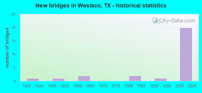
- New bridges - historical statistics
- 11940-1949
- 11950-1959
- 21960-1969
- 21980-1989
- 11990-1999
- 202000-2009

- Reconstructed bridges - Historical Statistics
- 11980-1989
- 01990-1999
- 12000-2009


- Bridge Condition - Deck
- 50.0%Good
- 50.0%Satisfactory

- Bridge Condition - Superstructure
- 18.8%Very good
- 56.3%Good
- 25.0%Satisfactory

- Bridge Condition - Substructure
- 62.5%Good
- 31.3%Satisfactory
- 6.3%Fair

- Bridge Condition - Channel
- 22.2%Good
- 55.6%Satisfactory
- 11.1%Fair
- 11.1%Poor
Find on map >> Show street view
Structure Number: 211090003918344, Location: 1.0 MI W OF N. TEXAS (Lat: 26.172869, Lng: -98.006703), Route carried "on" structure: US 83, Year Built: 2006, Status: Open, Structure Length: 6.71m (22.01ft), Average Daily Traffic: 46,000 (year 2013), Truck Traffic: 10%, Average Future Daily Traffic: 60,000 (year 2033), Design Load: HS 25 or greater, Features Intersected: MILE 6 ROAD
Minimum Vertical Clearance: 30+ m (98+ ft), Kilometerpoint: 56.179, Lanes on structure: 4, Lanes under structure: 8, Owner: State Highway Agency, Approaching Roadway Width: 20.7m (67.9ft), Material/Design: Prestressed concrete, Design/Construction: Stringer/Multi-beam, Number Of Spans In Main Unit: 1, Number Of Approach Spans: 2, Length of Maximum Span: 34.1m (111.9ft), Curb-To-Curb Width: 21.0m (68.9ft), Out-to-Out Width: 21.6m (70.9ft)
Condition: Deck: Satisfactory, Superstructure: Very good, Substructure: Good, Operating Rating: 68.0 metric tons, Method Used To Determine Operating Rating: Assigned rating based on Load Factor Design (LFD) reported in metric tons, Inventory Rating: 40.8 metric tons, Method Used To Determine Inventory Rating: Assigned rating based on Load Factor Design (LFD) reported in metric tons, Structural Evaluation: Better than present minimum criteria, Deck Geometry: Better than present minimum criteria, Underclear: Superior to present desirable criteria, Approach Roadway Alignment: Equal to present desirable criteria, Designated Inspection Frequency: Every 24 months, Inspection Date: May 2021, Deck Structure Type: Concrete Precast Panels
Find on map >> Show street view
Structure Number: 211090003918345, Location: 1.0 MI W OF N. TEXAS (Lat: 26.172539, Lng: -98.007311), Route carried "on" structure: US 83, Year Built: 2006, Status: Open, Structure Length: 6.71m (22.01ft), Average Daily Traffic: 30,010 (year 2011), Truck Traffic: 9%, Average Future Daily Traffic: 42,020 (year 2031), Design Load: HS 25 or greater, Features Intersected: MILE 6 ROAD
Minimum Vertical Clearance: 30+ m (98+ ft), Kilometerpoint: 62.216, Lanes on structure: 4, Lanes under structure: 8, Owner: State Highway Agency, Approaching Roadway Width: 20.7m (67.9ft), Material/Design: Prestressed concrete, Design/Construction: Stringer/Multi-beam, Number Of Spans In Main Unit: 1, Number Of Approach Spans: 2, Length of Maximum Span: 34.1m (111.9ft), Curb-To-Curb Width: 21.0m (68.9ft), Out-to-Out Width: 21.6m (70.9ft)
Condition: Deck: Satisfactory, Superstructure: Very good, Substructure: Good, Operating Rating: 68.0 metric tons, Method Used To Determine Operating Rating: Assigned rating based on Load Factor Design (LFD) reported in metric tons, Inventory Rating: 40.8 metric tons, Method Used To Determine Inventory Rating: Assigned rating based on Load Factor Design (LFD) reported in metric tons, Structural Evaluation: Better than present minimum criteria, Deck Geometry: Better than present minimum criteria, Underclear: Superior to present desirable criteria, Approach Roadway Alignment: Equal to present desirable criteria, Designated Inspection Frequency: Every 24 months, Inspection Date: May 2021, Deck Structure Type: Concrete Precast Panels
Find on map >> Show street view
Structure Number: 211090003918346, Location: 3.20 MI E OF FM 493 (Lat: 26.173064, Lng: -97.990589), Route carried "on" structure: US 83, Year Built: 2005, Status: Open, Structure Length: 6.71m (22.01ft), Average Daily Traffic: 30,010 (year 2011), Truck Traffic: 9%, Average Future Daily Traffic: 42,020 (year 2031), Design Load: HS 25 or greater, Features Intersected: FM 88
Minimum Vertical Clearance: 30+ m (98+ ft), Kilometerpoint: 63.825, Lanes on structure: 4, Lanes under structure: 8, Owner: State Highway Agency, Approaching Roadway Width: 20.7m (67.9ft), Material/Design: Prestressed concrete, Design/Construction: Stringer/Multi-beam, Number Of Spans In Main Unit: 1, Number Of Approach Spans: 2, Length of Maximum Span: 34.1m (111.9ft), Curb-To-Curb Width: 20.9m (68.6ft), Out-to-Out Width: 21.6m (70.9ft)
Condition: Deck: Good, Superstructure: Good, Substructure: Satisfactory, Operating Rating: 68.0 metric tons, Method Used To Determine Operating Rating: Assigned rating based on Load Factor Design (LFD) reported in metric tons, Inventory Rating: 40.8 metric tons, Method Used To Determine Inventory Rating: Assigned rating based on Load Factor Design (LFD) reported in metric tons, Structural Evaluation: Equal to present minimum criteria, Deck Geometry: Better than present minimum criteria, Underclear: Equal to present minimum criteria, Approach Roadway Alignment: Equal to present desirable criteria, Designated Inspection Frequency: Every 24 months, Inspection Date: April 2021, Deck Structure Type: Concrete Precast Panels
Find on map >> Show street view
Structure Number: 211090003918347, Location: 3.20 MI E OF FM 493 (Lat: 26.172719, Lng: -97.991192), Route carried "on" structure: US 83, Year Built: 2005, Status: Open, Structure Length: 6.71m (22.01ft), Average Daily Traffic: 30,010 (year 2011), Truck Traffic: 9%, Average Future Daily Traffic: 42,020 (year 2031), Design Load: HS 25 or greater, Features Intersected: FM 88
Minimum Vertical Clearance: 30+ m (98+ ft), Kilometerpoint: 63.825, Lanes on structure: 4, Lanes under structure: 8, Owner: State Highway Agency, Approaching Roadway Width: 20.7m (67.9ft), Material/Design: Prestressed concrete, Design/Construction: Stringer/Multi-beam, Number Of Spans In Main Unit: 1, Number Of Approach Spans: 2, Length of Maximum Span: 34.1m (111.9ft), Curb-To-Curb Width: 21.0m (68.9ft), Out-to-Out Width: 21.6m (70.9ft)
Condition: Deck: Good, Superstructure: Good, Substructure: Good, Operating Rating: 68.0 metric tons, Method Used To Determine Operating Rating: Assigned rating based on Load Factor Design (LFD) reported in metric tons, Inventory Rating: 40.8 metric tons, Method Used To Determine Inventory Rating: Assigned rating based on Load Factor Design (LFD) reported in metric tons, Structural Evaluation: Better than present minimum criteria, Deck Geometry: Better than present minimum criteria, Underclear: Equal to present minimum criteria, Approach Roadway Alignment: Equal to present desirable criteria, Designated Inspection Frequency: Every 24 months, Inspection Date: April 2021, Deck Structure Type: Concrete Precast Panels
Find on map >> Show street view
Structure Number: 211090003918348, Location: 2.0 MI NW OF FM 1015 (Lat: 26.172986, Lng: -97.980883), Route carried "on" structure: City street , Year Built: 2007, Status: Open, Structure Length: 10.00m (32.81ft), Average Daily Traffic: 7,931 (year 2019), Truck Traffic: 1%, Average Future Daily Traffic: 600 (year 2029), Design Load: HS 25 or greater, Features Intersected: US 83, Facility Carried by Structure: PASO DEL NORTE
Minimum Vertical Clearance: 5.26m (17.26ft), Kilometerpoint: 0.000, Lanes on structure: 4, Lanes under structure: 12, Owner: State Highway Agency, Approaching Roadway Width: 15.9m (52.2ft), Skew: 1 degrees, Material/Design: Prestressed concrete, Design/Construction: Stringer/Multi-beam, Number Of Spans In Main Unit: 4, Length of Maximum Span: 25.0m (82.0ft), Curb or Sidewalk Widths: Left: 0.0m, Right: 1.8m (5.9ft), Curb-To-Curb Width: 15.7m (51.5ft), Out-to-Out Width: 18.6m (61.0ft)
Condition: Deck: Good, Superstructure: Good, Substructure: Good, Operating Rating: 68.0 metric tons, Method Used To Determine Operating Rating: Assigned rating based on Load Factor Design (LFD) reported in metric tons, Inventory Rating: 40.8 metric tons, Method Used To Determine Inventory Rating: Assigned rating based on Load Factor Design (LFD) reported in metric tons, Structural Evaluation: Better than present minimum criteria, Deck Geometry: Meets minimum limits, Underclear: Equal to present minimum criteria, Approach Roadway Alignment: Equal to present desirable criteria, Designated Inspection Frequency: Every 24 months, Inspection Date: May 2021, Deck Structure Type: Concrete Cast-file-Place
Find on map >> Show street view
Structure Number: 211090003918349, Location: 1.20 MI NW OF FM 1015 (Lat: 26.170261, Lng: -97.974461), Route carried "on" structure: US 83, Year Built: 2006, Status: Open, Structure Length: 7.68m (25.20ft), Average Daily Traffic: 30,010 (year 2011), Truck Traffic: 9%, Average Future Daily Traffic: 42,020 (year 2031), Design Load: HS 25 or greater, Features Intersected: AIRPORT DR.
Minimum Vertical Clearance: 30+ m (98+ ft), Kilometerpoint: 65.491, Lanes on structure: 4, Lanes under structure: 8, Owner: State Highway Agency, Approaching Roadway Width: 20.7m (67.9ft), Skew: 2 degrees, Material/Design: Prestressed concrete, Design/Construction: Stringer/Multi-beam, Number Of Spans In Main Unit: 1, Number Of Approach Spans: 2, Length of Maximum Span: 37.2m (122.0ft), Curb-To-Curb Width: 20.7m (67.9ft), Out-to-Out Width: 21.6m (70.9ft)
Condition: Deck: Satisfactory, Superstructure: Very good, Substructure: Good, Operating Rating: 68.0 metric tons, Method Used To Determine Operating Rating: Assigned rating based on Load Factor Design (LFD) reported in metric tons, Inventory Rating: 40.8 metric tons, Method Used To Determine Inventory Rating: Assigned rating based on Load Factor Design (LFD) reported in metric tons, Structural Evaluation: Better than present minimum criteria, Deck Geometry: Equal to present minimum criteria, Underclear: Superior to present desirable criteria, Approach Roadway Alignment: Equal to present desirable criteria, Designated Inspection Frequency: Every 24 months, Inspection Date: May 2021, Deck Structure Type: Concrete Cast-file-Place
Find on map >> Show street view
Structure Number: 21109000391835, Location: 1.20 MI NW OF FM 1015 (Lat: 26.170097, Lng: -97.975044), Route carried "on" structure: US 83, Year Built: 2006, Status: Open, Structure Length: 7.68m (25.20ft), Average Daily Traffic: 30,010 (year 2011), Truck Traffic: 9%, Average Future Daily Traffic: 42,020 (year 2031), Design Load: HS 25 or greater, Features Intersected: AIRPORT DR.
Minimum Vertical Clearance: 30+ m (98+ ft), Kilometerpoint: 65.500, Lanes on structure: 4, Lanes under structure: 8, Owner: State Highway Agency, Approaching Roadway Width: 20.7m (67.9ft), Skew: 2 degrees, Material/Design: Prestressed concrete, Design/Construction: Stringer/Multi-beam, Number Of Spans In Main Unit: 1, Number Of Approach Spans: 2, Length of Maximum Span: 37.2m (122.0ft), Curb-To-Curb Width: 20.7m (67.9ft), Out-to-Out Width: 21.6m (70.9ft)
Condition: Deck: Good, Superstructure: Good, Substructure: Good, Operating Rating: 68.0 metric tons, Method Used To Determine Operating Rating: Assigned rating based on Load Factor Design (LFD) reported in metric tons, Inventory Rating: 40.8 metric tons, Method Used To Determine Inventory Rating: Assigned rating based on Load Factor Design (LFD) reported in metric tons, Structural Evaluation: Better than present minimum criteria, Deck Geometry: Equal to present minimum criteria, Underclear: Superior to present desirable criteria, Approach Roadway Alignment: Equal to present desirable criteria, Designated Inspection Frequency: Every 24 months, Inspection Date: May 2021, Deck Structure Type: Concrete Cast-file-Place
Find on map >> Show street view
Structure Number: 211090003918351, Location: 2.20 MI SE OF FM 88 (Lat: 26.161217, Lng: -97.958122), Route carried "on" structure: US 83, Year Built: 2005, Status: Open, Structure Length: 8.50m (27.89ft), Average Daily Traffic: 30,010 (year 2011), Truck Traffic: 9%, Average Future Daily Traffic: 42,020 (year 2031), Design Load: HS 25 or greater, Features Intersected: FM 1015 (MILE 3 WEST RD)
Minimum Vertical Clearance: 30+ m (98+ ft), Kilometerpoint: 67.391, Lanes on structure: 4, Lanes under structure: 8, Owner: State Highway Agency, Approaching Roadway Width: 20.7m (67.9ft), Skew: 3 degrees, Material/Design: Prestressed concrete, Design/Construction: Stringer/Multi-beam, Number Of Spans In Main Unit: 1, Number Of Approach Spans: 2, Length of Maximum Span: 40.5m (132.9ft), Curb-To-Curb Width: 21.0m (68.9ft), Out-to-Out Width: 21.6m (70.9ft)
Condition: Deck: Good, Superstructure: Good, Substructure: Good, Operating Rating: 68.0 metric tons, Method Used To Determine Operating Rating: Assigned rating based on Load Factor Design (LFD) reported in metric tons, Inventory Rating: 40.8 metric tons, Method Used To Determine Inventory Rating: Assigned rating based on Load Factor Design (LFD) reported in metric tons, Structural Evaluation: Better than present minimum criteria, Deck Geometry: Better than present minimum criteria, Underclear: Equal to present minimum criteria, Approach Roadway Alignment: Equal to present desirable criteria, Designated Inspection Frequency: Every 24 months, Inspection Date: April 2021, Deck Structure Type: Concrete Precast Panels
Find on map >> Show street view
Structure Number: 211090003918352, Location: 2.20 MI SE OF FM 88 (Lat: 26.161269, Lng: -97.958806), Route carried "on" structure: US 83, Year Built: 2005, Status: Open, Structure Length: 8.50m (27.89ft), Average Daily Traffic: 30,010 (year 2011), Truck Traffic: 9%, Average Future Daily Traffic: 42,020 (year 2031), Design Load: HS 25 or greater, Features Intersected: FM 1015 (MILE 3 WEST RD)
Minimum Vertical Clearance: 30+ m (98+ ft), Kilometerpoint: 67.404, Lanes on structure: 4, Lanes under structure: 8, Owner: State Highway Agency, Approaching Roadway Width: 20.7m (67.9ft), Skew: 3 degrees, Material/Design: Prestressed concrete, Design/Construction: Stringer/Multi-beam, Number Of Spans In Main Unit: 1, Number Of Approach Spans: 2, Length of Maximum Span: 40.5m (132.9ft), Curb-To-Curb Width: 21.0m (68.9ft), Out-to-Out Width: 21.6m (70.9ft)
Condition: Deck: Good, Superstructure: Good, Substructure: Good, Operating Rating: 68.0 metric tons, Method Used To Determine Operating Rating: Assigned rating based on Load Factor Design (LFD) reported in metric tons, Inventory Rating: 40.8 metric tons, Method Used To Determine Inventory Rating: Assigned rating based on Load Factor Design (LFD) reported in metric tons, Structural Evaluation: Better than present minimum criteria, Deck Geometry: Better than present minimum criteria, Underclear: Equal to present minimum criteria, Approach Roadway Alignment: Equal to present desirable criteria, Designated Inspection Frequency: Every 24 months, Inspection Date: April 2021, Deck Structure Type: Concrete Precast Panels
Find on map >> Show street view
Structure Number: 211090069804004, Location: 2.00 MI N OF US 281 (Lat: 26.113464, Lng: -97.993481), Route carried "on" structure: State highway 88, Year Built: 1963, Status: Open, Structure Length: 96.96m (318.11ft), Average Daily Traffic: 2,871 (year 2020), Truck Traffic: 27%, Average Future Daily Traffic: 2,630 (year 2033), Features Intersected: MAIN FLOODWAY
Minimum Vertical Clearance: 30+ m (98+ ft), Kilometerpoint: 36.954, Lanes on structure: 2, Owner: State Highway Agency, Approaching Roadway Width: 11.6m (38.1ft), Material/Design: Concrete, Design/Construction: Stringer/Multi-beam, Number Of Spans In Main Unit: 78, Number Of Approach Spans: 2, Length of Maximum Span: 12.2m (40.0ft), Curb-To-Curb Width: 9.1m (29.9ft), Out-to-Out Width: 10.1m (33.1ft)
Condition: Deck: Satisfactory, Superstructure: Satisfactory, Substructure: Satisfactory, Channel: Satisfactory, Operating Rating: 46.3 metric tons, Method Used To Determine Operating Rating: Load Factor (LF), Inventory Rating: 27.2 metric tons, Method Used To Determine Inventory Rating: Load Factor (LF), Structural Evaluation: Equal to present minimum criteria, Deck Geometry: Meets minimum limits, Waterway Adequacy: Superior to present desirable criteria, Approach Roadway Alignment: Equal to present desirable criteria, Designated Inspection Frequency: Every 24 months, Inspection Date: May 2021, Deck Structure Type: Concrete Cast-file-Place, Wearing Surface/Protective System: Wearing Surface: Bituminous
Find on map >> Show street view
Structure Number: 211090122803011, Location: 1.95 MI N OF US 83 (Lat: 26.189553, Lng: -97.959008), Route carried "on" structure: State highway 1015, Year Built: 1986, Year Reconstructed: 2009, Status: Open, Structure Length: 5.49m (18.01ft), Average Daily Traffic: 6,202 (year 2020), Truck Traffic: 5%, Average Future Daily Traffic: 7,500 (year 2033), Design Load: HS 20, Features Intersected: MAIN SUPPLY CANAL
Minimum Vertical Clearance: 30+ m (98+ ft), Kilometerpoint: 11.542, Lanes on structure: 5, Owner: State Highway Agency, Approaching Roadway Width: 25.6m (84.0ft), Skew: 5 degrees, Material/Design: Concrete continuous, Design/Construction: Slab, Number Of Spans In Main Unit: 6, Length of Maximum Span: 9.1m (29.9ft), Curb-To-Curb Width: 25.5m (83.7ft), Out-to-Out Width: 26.2m (86.0ft)
Condition: Deck: Good, Superstructure: Good, Substructure: Good, Channel: Good, Operating Rating: 58.0 metric tons, Method Used To Determine Operating Rating: Load Factor (LF), Inventory Rating: 35.4 metric tons, Method Used To Determine Inventory Rating: Load Factor (LF), Structural Evaluation: Better than present minimum criteria, Deck Geometry: Superior to present desirable criteria, Waterway Adequacy: Superior to present desirable criteria, Approach Roadway Alignment: Equal to present desirable criteria, Designated Inspection Frequency: Every 24 months, Underwater Inspection Frequency: Every 60 months, Inspection Date: May 2021, Underwater Inspection Date: September 2019, Deck Structure Type: Concrete Cast-file-Place
Find on map >> Show street view
Structure Number: 211090AA0707001, Location: 0.1 MILE EAST OF FM 88 (Lat: 26.126464, Lng: -97.987961), Route carried "on" structure: County highway , Year Built: 1996, Status: Open, Structure Length: 1.89m (6.20ft), Average Daily Traffic: 1,844 (year 2020), Average Future Daily Traffic: 1,400 (year 2032), Design Load: HS 20, Features Intersected: DRAINAGE DITCH 37, Facility Carried by Structure: MILE 5 N RD
Minimum Vertical Clearance: 30+ m (98+ ft), Kilometerpoint: 0.161, Lanes on structure: 2, Owner: County Highway Agency, Approaching Roadway Width: 6.7m (22.0ft), Material/Design: Concrete, Design/Construction: Stringer/Multi-beam, Number Of Spans In Main Unit: 2, Length of Maximum Span: 9.1m (29.9ft), Curb-To-Curb Width: 8.6m (28.2ft), Out-to-Out Width: 9.2m (30.2ft)
Condition: Deck: Satisfactory, Superstructure: Satisfactory, Substructure: Satisfactory, Channel: Good, Operating Rating: 58.0 metric tons, Method Used To Determine Operating Rating: Load Factor (LF), Inventory Rating: 35.4 metric tons, Method Used To Determine Inventory Rating: Load Factor (LF), Structural Evaluation: Equal to present minimum criteria, Deck Geometry: Somewhat better than minimum adequacy, Waterway Adequacy: Better than present minimum criteria, Approach Roadway Alignment: Equal to present desirable criteria, Designated Inspection Frequency: Every 24 months, Inspection Date: April 2020, Deck Structure Type: Concrete Cast-file-Place
Find on map >> Show street view
Structure Number: 211090AA0807001, Location: 0.65 MI E OF JCT FM 1015 (Lat: 26.199672, Lng: -97.947414), Route carried "on" structure: County highway , Year Built: 1955, Status: Open, Structure Length: 1.19m (3.90ft), Average Daily Traffic: 621 (year 2020), Truck Traffic: 1%, Average Future Daily Traffic: 800 (year 2032), Features Intersected: IRRIGATION CANAL, Facility Carried by Structure: MILE 10 NORTH RD
Minimum Vertical Clearance: 30+ m (98+ ft), Kilometerpoint: 1.046, Lanes on structure: 2, Owner: County Highway Agency, Approaching Roadway Width: 4.9m (16.1ft), Skew: 4 degrees, Material/Design: Concrete, Design/Construction: Tee Beam, Number Of Spans In Main Unit: 1, Length of Maximum Span: 11.3m (37.1ft), Curb-To-Curb Width: 6.1m (20.0ft), Out-to-Out Width: 7.0m (23.0ft)
Condition: Deck: Satisfactory, Superstructure: Good, Substructure: Good, Channel: Satisfactory, Operating Rating: 32.7 metric tons, Method Used To Determine Operating Rating: Field evaluation and documented engineering judgment, Inventory Rating: 24.5 metric tons, Method Used To Determine Inventory Rating: Field evaluation and documented engineering judgment, Structural Evaluation: Equal to present minimum criteria, Deck Geometry: High priority of corrective action, Waterway Adequacy: Better than present minimum criteria, Approach Roadway Alignment: Better than present minimum criteria, Length Of Structure Improvement: 1.19m (3.90ft), Designated Inspection Frequency: Every 24 months, Inspection Date: May 2020, Bridge Improvement Cost: $2,000, Roadway Improvement Cost: $1,000, Total Project Cost: $3,000, Deck Structure Type: Concrete Cast-file-Place
Find on map >> Show street view
Structure Number: 211090AA0825002, Location: 1.04 MI N OF MILE 9 N RD (Lat: 26.200239, Lng: -97.943122), Route carried "on" structure: County highway , Year Built: 2004, Status: Open, Structure Length: 1.07m (3.51ft), Average Daily Traffic: 2,569 (year 2019), Truck Traffic: 2%, Average Future Daily Traffic: 1,640 (year 2032), Design Load: HS 20, Features Intersected: MAIN SUPPLY CANAL, Facility Carried by Structure: MILE 2 WEST ROAD
Minimum Vertical Clearance: 30+ m (98+ ft), Kilometerpoint: 12.875, Lanes on structure: 2, Owner: County Highway Agency, Approaching Roadway Width: 6.7m (22.0ft), Material/Design: Concrete, Design/Construction: Culvert, Number Of Spans In Main Unit: 4, Length of Maximum Span: 2.4m (7.9ft)
Condition: Channel: Satisfactory, Culverts: Good, Operating Rating: 54.4 metric tons, Method Used To Determine Operating Rating: Assigned rating based on Load Factor Design (LFD) reported in metric tons, Inventory Rating: 32.7 metric tons, Method Used To Determine Inventory Rating: Assigned rating based on Load Factor Design (LFD) reported in metric tons, Structural Evaluation: Better than present minimum criteria, Waterway Adequacy: Superior to present desirable criteria, Approach Roadway Alignment: Equal to present desirable criteria, Designated Inspection Frequency: Every 24 months, Underwater Inspection Frequency: Every 60 months, Inspection Date: May 2020, Underwater Inspection Date: September 2019
Find on map >> Show street view
Structure Number: 211090AA2095001, Location: 0.4 MI W OF MI 3 1/2 W RD (Lat: 26.133950, Lng: -97.972883), Route carried "on" structure: County highway , Year Built: 1980, Status: Open, Structure Length: 2.77m (9.09ft), Average Daily Traffic: 300 (year 2010), Truck Traffic: 10%, Average Future Daily Traffic: 400 (year 2032), Features Intersected: WESLACO MAIN DRAIN, Facility Carried by Structure: MILE 5 1/2 N RD
Minimum Vertical Clearance: 30+ m (98+ ft), Kilometerpoint: 0.644, Lanes on structure: 2, Owner: County Highway Agency, Approaching Roadway Width: 6.1m (20.0ft), Material/Design: Concrete, Design/Construction: Stringer/Multi-beam, Number Of Spans In Main Unit: 3, Length of Maximum Span: 9.1m (29.9ft), Curb-To-Curb Width: 7.9m (25.9ft), Out-to-Out Width: 8.6m (28.2ft)
Condition: Deck: Satisfactory, Superstructure: Satisfactory, Substructure: Satisfactory, Channel: Satisfactory, Operating Rating: 32.7 metric tons, Method Used To Determine Operating Rating: Field evaluation and documented engineering judgment, Inventory Rating: 24.5 metric tons, Method Used To Determine Inventory Rating: Field evaluation and documented engineering judgment, Structural Evaluation: Equal to present minimum criteria, Deck Geometry: Somewhat better than minimum adequacy, Waterway Adequacy: Better than present minimum criteria, Approach Roadway Alignment: Equal to present desirable criteria, Designated Inspection Frequency: Every 24 months, Inspection Date: May 2020, Deck Structure Type: Concrete Cast-file-Place, Wearing Surface/Protective System: Wearing Surface: Bituminous
Find on map >> Show street view
Structure Number: 211090T00030001, Location: 0.2 MI N. OF US 83 (Lat: 26.173786, Lng: -97.974717), Route carried "on" structure: City street , Year Built: 2006, Status: Open, Structure Length: 0.73m (2.40ft), Average Daily Traffic: 800 (year 2014), Truck Traffic: 1%, Average Future Daily Traffic: 960 (year 2034), Design Load: HS 20, Features Intersected: DRAIN DITCH LATERAL 18B, Facility Carried by Structure: AIRPORT DR.
Minimum Vertical Clearance: 30+ m (98+ ft), Kilometerpoint: 0.322, Lanes on structure: 2, Owner: City or Municipal Highway Agency, Approaching Roadway Width: 14.6m (47.9ft), Material/Design: Concrete, Design/Construction: Culvert, Number Of Spans In Main Unit: 2, Length of Maximum Span: 3.0m (9.8ft), Curb-To-Curb Width: 28.7m (94.2ft), Out-to-Out Width: 31.7m (104.0ft)
Condition: Channel: Satisfactory, Culverts: Good, Operating Rating: 54.4 metric tons, Method Used To Determine Operating Rating: Assigned rating based on Load Factor Design (LFD) reported in metric tons, Inventory Rating: 32.7 metric tons, Method Used To Determine Inventory Rating: Assigned rating based on Load Factor Design (LFD) reported in metric tons, Structural Evaluation: Better than present minimum criteria, Deck Geometry: Superior to present desirable criteria, Waterway Adequacy: Better than present minimum criteria, Approach Roadway Alignment: Equal to present desirable criteria, Designated Inspection Frequency: Every 24 months, Inspection Date: May 2020
Find on map >> Show street view
Structure Number: 211090T00655001, Location: 0.1 MI N OF MILE 19 N RD (Lat: 26.186633, Lng: -97.983142), Route carried "on" structure: City street , Year Built: 1948, Status: Open, Structure Length: 2.83m (9.28ft), Average Daily Traffic: 2,800 (year 2010), Truck Traffic: 1%, Average Future Daily Traffic: 3,000 (year 2032), Features Intersected: MAIN SUPPLY CANAL, Facility Carried by Structure: MILE 4 1/2 WEST RD
Minimum Vertical Clearance: 30+ m (98+ ft), Kilometerpoint: 4.667, Lanes on structure: 2, Owner: City or Municipal Highway Agency, Approaching Roadway Width: 5.5m (18.0ft), Material/Design: Concrete, Design/Construction: Stringer/Multi-beam, Number Of Spans In Main Unit: 3, Length of Maximum Span: 9.1m (29.9ft), Curb-To-Curb Width: 6.9m (22.6ft), Out-to-Out Width: 7.5m (24.6ft)
Condition: Deck: Good, Superstructure: Good, Substructure: Fair, Channel: Poor, Operating Rating: 32.7 metric tons, Method Used To Determine Operating Rating: Field evaluation and documented engineering judgment, Inventory Rating: 24.5 metric tons, Method Used To Determine Inventory Rating: Field evaluation and documented engineering judgment, Structural Evaluation: Somewhat better than minimum adequacy, Deck Geometry: High priority of replacement, Waterway Adequacy: Better than present minimum criteria, Approach Roadway Alignment: Equal to present minimum criteria, Length Of Structure Improvement: 2.83m (9.28ft), Designated Inspection Frequency: Every 24 months, Underwater Inspection Frequency: Every 24 months, Inspection Date: May 2020, Underwater Inspection Date: Febuary 2021, Bridge Improvement Cost: $4,000, Roadway Improvement Cost: $1,000, Total Project Cost: $5,000, Deck Structure Type: Concrete Cast-file-Place
Find on map >> Show street view
Structure Number: 211090T00715001, Location: .3 MI W OF MI 4-1/2 W RD (Lat: 26.184686, Lng: -97.988378), Route carried "on" structure: City street , Year Built: 1965, Year Reconstructed: 1991, Status: Open, Structure Length: 1.28m (4.20ft), Average Daily Traffic: 3,460 (year 2010), Truck Traffic: 1%, Average Future Daily Traffic: 4,000 (year 2032), Features Intersected: MAIN SUPPLY CANAL, Facility Carried by Structure: SUGAR CANE DRIVE
Minimum Vertical Clearance: 30+ m (98+ ft), Kilometerpoint: 0.483, Lanes on structure: 2, Owner: City or Municipal Highway Agency, Approaching Roadway Width: 11.6m (38.1ft), Material/Design: Concrete, Design/Construction: Stringer/Multi-beam, Number Of Spans In Main Unit: 1, Length of Maximum Span: 12.2m (40.0ft), Curb or Sidewalk Widths: Left: 1.3m (4.3ft), Right: 1.3m (4.3ft), Curb-To-Curb Width: 11.8m (38.7ft), Out-to-Out Width: 15.9m (52.2ft)
Condition: Deck: Satisfactory, Superstructure: Satisfactory, Substructure: Satisfactory, Channel: Fair, Operating Rating: 32.7 metric tons, Method Used To Determine Operating Rating: Field evaluation and documented engineering judgment, Inventory Rating: 24.5 metric tons, Method Used To Determine Inventory Rating: Field evaluation and documented engineering judgment, Structural Evaluation: Equal to present minimum criteria, Deck Geometry: Somewhat better than minimum adequacy, Waterway Adequacy: Better than present minimum criteria, Approach Roadway Alignment: Equal to present minimum criteria, Designated Inspection Frequency: Every 24 months, Inspection Date: May 2020, Deck Structure Type: Concrete Cast-file-Place
Find on map >> Show street view
Structure Number: 211090003918344, Location: 1.0 MI W OF N. TEXAS (Lat: 26.172869, Lng: -98.006703), Route carried "under" structure: County highway , Year Built: 2006, Structure Length: 0. m, Average Daily Traffic: 13,730 (year 2009), Features Intersected: MILE 6 ROAD, Facility Carried by Structure: US 83 WB
Minimum Vertical Clearance: 5.11m (16.77ft), Kilometerpoint: 0.000, Lanes on structure: 4, Lanes under structure: 8, Material/Design: Prestressed concrete, Design/Construction: Stringer/Multi-beam, Length of Maximum Span: 34.1m (111.9ft)
Find on map >> Show street view
Structure Number: 211090003918345, Location: 1.0 MI W OF N. TEXAS (Lat: 26.172539, Lng: -98.007311), Route carried "under" structure: County highway , Year Built: 2006, Structure Length: 0. m, Average Daily Traffic: 13,730 (year 2009), Features Intersected: MILE 6 ROAD, Facility Carried by Structure: US 83 EB
Minimum Vertical Clearance: 5.16m (16.93ft), Lanes on structure: 4, Lanes under structure: 8, Material/Design: Prestressed concrete, Design/Construction: Stringer/Multi-beam, Length of Maximum Span: 34.1m (111.9ft)
Find on map >> Show street view
Structure Number: 211090003918346, Location: 3.20 MI E OF FM 493 (Lat: 26.173064, Lng: -97.990589), Route carried "under" structure: State highway 88, Year Built: 2005, Structure Length: 0. m, Average Daily Traffic: 24,420 (year 2013), Truck Traffic: 27%, Features Intersected: FM 88, Facility Carried by Structure: US 83 WB
Minimum Vertical Clearance: 5.03m (16.50ft), Kilometerpoint: 30.753, Lanes on structure: 4, Lanes under structure: 8, Material/Design: Prestressed concrete, Design/Construction: Stringer/Multi-beam, Length of Maximum Span: 34.1m (111.9ft)
Find on map >> Show street view
Structure Number: 211090003918347, Location: 3.20 MI E OF FM 493 (Lat: 26.172719, Lng: -97.991192), Route carried "under" structure: State highway 88, Year Built: 2005, Structure Length: 0. m, Average Daily Traffic: 24,420 (year 2013), Truck Traffic: 27%, Features Intersected: FM 88, Facility Carried by Structure: US 83 EB
Minimum Vertical Clearance: 5.01m (16.44ft), Kilometerpoint: 30.771, Lanes on structure: 4, Lanes under structure: 8, Material/Design: Prestressed concrete, Design/Construction: Stringer/Multi-beam, Length of Maximum Span: 34.1m (111.9ft)
Find on map >> Show street view
Structure Number: 211090003918348, Location: 2.0 MI NW OF FM 1015 (Lat: 26.172986, Lng: -97.980883), Route carried "under" structure: US 83, Year Built: 2007, Structure Length: 0. m, Average Daily Traffic: 60,030 (year 2011), Truck Traffic: 9%, Features Intersected: US 83, Facility Carried by Structure: PASO DEL NORTE
Minimum Vertical Clearance: 5.26m (17.26ft), Kilometerpoint: 64.873, Lanes on structure: 4, Lanes under structure: 12, Material/Design: Prestressed concrete, Design/Construction: Stringer/Multi-beam, Length of Maximum Span: 25.0m (82.0ft)
Find on map >> Show street view
Structure Number: 211090003918349, Location: 1.20 MI NW OF FM 1015 (Lat: 26.170261, Lng: -97.974461), Route carried "under" structure: City street , Year Built: 2006, Structure Length: 0. m, Average Daily Traffic: 2,000 (year 2009), Truck Traffic: 2%, Features Intersected: AIRPORT DR., Facility Carried by Structure: US 83 WB
Minimum Vertical Clearance: 5.16m (16.93ft), Kilometerpoint: 0.000, Lanes on structure: 4, Lanes under structure: 8, Material/Design: Prestressed concrete, Design/Construction: Stringer/Multi-beam, Length of Maximum Span: 37.2m (122.0ft)
Find on map >> Show street view
Structure Number: 21109000391835, Location: 1.20 MI NW OF FM 1015 (Lat: 26.170097, Lng: -97.975044), Route carried "under" structure: City street , Year Built: 2006, Structure Length: 0. m, Average Daily Traffic: 2,000 (year 2009), Truck Traffic: 2%, Features Intersected: AIRPORT DR., Facility Carried by Structure: US 83 EB
Minimum Vertical Clearance: 5.13m (16.83ft), Kilometerpoint: 0.000, Lanes on structure: 4, Lanes under structure: 8, Material/Design: Prestressed concrete, Design/Construction: Stringer/Multi-beam, Length of Maximum Span: 37.2m (122.0ft)
Find on map >> Show street view
Structure Number: 211090003918351, Location: 2.20 MI SE OF FM 88 (Lat: 26.161217, Lng: -97.958122), Route carried "under" structure: State highway 1015, Year Built: 2005, Structure Length: 0. m, Average Daily Traffic: 17,410 (year 2013), Truck Traffic: 5%, Features Intersected: FM 1015 (MILE 3 WEST RD), Facility Carried by Structure: US 83 WB
Minimum Vertical Clearance: 5.08m (16.67ft), Kilometerpoint: 14.722, Lanes on structure: 4, Lanes under structure: 8, Material/Design: Prestressed concrete, Design/Construction: Stringer/Multi-beam, Length of Maximum Span: 40.5m (132.9ft)
Find on map >> Show street view
Structure Number: 211090003918352, Location: 2.20 MI SE OF FM 88 (Lat: 26.161269, Lng: -97.958806), Route carried "under" structure: State highway 1015, Year Built: 2005, Structure Length: 0. m, Average Daily Traffic: 17,410 (year 2013), Truck Traffic: 5%, Features Intersected: FM 1015 (MILE 3 WEST RD), Facility Carried by Structure: US 83 EB
Minimum Vertical Clearance: 5.11m (16.77ft), Kilometerpoint: 14.745, Lanes on structure: 4, Lanes under structure: 8, Material/Design: Prestressed concrete, Design/Construction: Stringer/Multi-beam, Length of Maximum Span: 40.5m (132.9ft)