Bridge Statistics for Wellington, Colorado (CO)
Condition, Traffic, Stress, Structural Evaluation, Project Costs
- National Bridge Inventory (NBI) Statistics
- 44Number of bridges
- 256ft / 78.5mTotal length
- 345,911Total average daily traffic
- 56,950Total average daily truck traffic
- National Bridge Inventory (NBI) Registered Bridges for Wellington
- No street view available for this location
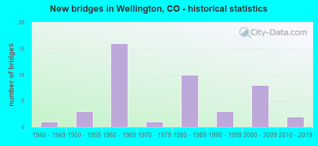
- New bridges - historical statistics
- 11940-1949
- 31950-1959
- 161960-1969
- 11970-1979
- 101980-1989
- 31990-1999
- 82000-2009
- 22010-2019

- Reconstructed bridges - Historical Statistics
- 31970-1979
- 21980-1989


- Bridge Condition - Deck
- 12.0%Very good
- 44.0%Good
- 16.0%Satisfactory
- 28.0%Fair

- Bridge Condition - Superstructure
- 20.0%Very good
- 36.0%Good
- 28.0%Satisfactory
- 16.0%Fair

- Bridge Condition - Substructure
- 4.0%Very good
- 44.0%Good
- 36.0%Satisfactory
- 16.0%Fair

- Bridge Condition - Channel
- 36.1%Very good
- 41.7%Good
- 19.4%Satisfactory
- 2.8%Poor

- Bridge Condition - Culverts
- 40.0%Good
- 46.7%Satisfactory
- 13.3%Fair
Find on map >> Show street view
Structure Number: A-17-AX, Location: 17.8 MI SOUTH OF WYOMING (Lat: 40.749492, Lng: -104.992875), Route carried "on" structure: Interstate 25A, Year Built: 1967, Status: Open, Structure Length: 1.50m (4.92ft), Average Daily Traffic: 12,500 (year 2020), Truck Traffic: 14%, Average Future Daily Traffic: 18,750 (year 2040), Design Load: HS 20, Features Intersected: N.POUDRE DITCH,SAND CRK, Facility Carried by Structure: I 25 ML SBND
Minimum Vertical Clearance: 30+ m (98+ ft), Kilometerpoint: 451.880, Lanes on structure: 2, Base Highway Network: Yes, Owner: State Highway Agency, Approaching Roadway Width: 11.6m (38.1ft), Skew: 12 degrees, Material/Design: Concrete, Design/Construction: Tee Beam, Number Of Spans In Main Unit: 1, Length of Maximum Span: 14.3m (46.9ft), Curb-To-Curb Width: 11.6m (38.1ft), Out-to-Out Width: 12.3m (40.4ft)
Condition: Deck: Satisfactory, Superstructure: Good, Substructure: Satisfactory, Channel: Very good, Operating Rating: 52.0 metric tons, Method Used To Determine Operating Rating: Load Factor (LF), Inventory Rating: 31.1 metric tons, Method Used To Determine Inventory Rating: Load Factor (LF), Structural Evaluation: Equal to present minimum criteria, Deck Geometry: Equal to present minimum criteria, Waterway Adequacy: Equal to present desirable criteria, Approach Roadway Alignment: Equal to present desirable criteria, Designated Inspection Frequency: Every 24 months, Inspection Date: March 2021, Deck Structure Type: Concrete Cast-file-Place, Wearing Surface/Protective System: Wearing Surface: Other, Membrane: Other
Find on map >> Show street view
Structure Number: A-17-AY, Location: 11.6 MI NORTH OF JCT SH 1 (Lat: 40.749456, Lng: -104.992192), Route carried "on" structure: ServiceInterstate 25A, Year Built: 1967, Status: Open, Structure Length: 1.34m (4.40ft), Average Daily Traffic: 25,000 (year 2020), Truck Traffic: 14%, Average Future Daily Traffic: 37,500 (year 2040), Design Load: HS 20, Features Intersected: N.POUDRE DITCH,SAND C SR, Facility Carried by Structure: I 25 SERVICE RD
Minimum Vertical Clearance: 30+ m (98+ ft), Kilometerpoint: 24.830, Lanes on structure: 2, Base Highway Network: Yes, Owner: State Highway Agency, Approaching Roadway Width: 8.5m (27.9ft), Skew: 10 degrees, Material/Design: Concrete, Design/Construction: Tee Beam, Number Of Spans In Main Unit: 1, Length of Maximum Span: 12.8m (42.0ft), Curb-To-Curb Width: 10.4m (34.1ft), Out-to-Out Width: 11.3m (37.1ft)
Condition: Deck: Good, Superstructure: Good, Substructure: Good, Channel: Satisfactory, Operating Rating: 36.3 metric tons, Method Used To Determine Operating Rating: Load Factor (LF), Inventory Rating: 21.8 metric tons, Method Used To Determine Inventory Rating: Load Factor (LF), Structural Evaluation: Somewhat better than minimum adequacy, Deck Geometry: Meets minimum limits, Waterway Adequacy: Equal to present desirable criteria, Approach Roadway Alignment: Equal to present desirable criteria, Designated Inspection Frequency: Every 24 months, Inspection Date: March 2021, Deck Structure Type: Concrete Cast-file-Place, Wearing Surface/Protective System: Wearing Surface: Bituminous
Find on map >> Show street view
Structure Number: A-17-S, Location: 11.6 MI NORTH OF JCT SH 1 (Lat: 40.749442, Lng: -104.992408), Route carried "on" structure: Interstate 25A, Year Built: 1950, Status: Open, Structure Length: 1.48m (4.86ft), Average Daily Traffic: 12,500 (year 2020), Truck Traffic: 14%, Average Future Daily Traffic: 18,750 (year 2040), Design Load: HS 20, Features Intersected: N.POUDRE DITCH,SAND CRK, Facility Carried by Structure: I 25 ML NBND
Minimum Vertical Clearance: 30+ m (98+ ft), Kilometerpoint: 451.875, Lanes on structure: 2, Base Highway Network: Yes, Owner: State Highway Agency, Approaching Roadway Width: 11.6m (38.1ft), Skew: 10 degrees, Material/Design: Steel, Design/Construction: Stringer/Multi-beam, Number Of Spans In Main Unit: 1, Length of Maximum Span: 13.7m (44.9ft), Curb-To-Curb Width: 13.4m (44.0ft), Out-to-Out Width: 14.6m (47.9ft)
Condition: Deck: Good, Superstructure: Satisfactory, Substructure: Satisfactory, Channel: Satisfactory, Operating Rating: 31.9 metric tons, Method Used To Determine Operating Rating: Load Factor (LF), Inventory Rating: 19.1 metric tons, Method Used To Determine Inventory Rating: Load Factor (LF), Structural Evaluation: Meets minimum limits, Deck Geometry: Superior to present desirable criteria, Waterway Adequacy: Equal to present desirable criteria, Approach Roadway Alignment: Equal to present desirable criteria, Designated Inspection Frequency: Every 24 months, Inspection Date: March 2021, Deck Structure Type: Concrete Cast-file-Place, Wearing Surface/Protective System: Wearing Surface: Bituminous, Membrane: Preformed Fabric
Find on map >> Show street view
Structure Number: A-17-V, Location: 12 MI NORTH OF JCT SH 14 (Lat: 40.755167, Lng: -104.992464), Route carried "on" structure: County highway , Year Built: 1967, Status: Open, Structure Length: 7.53m (24.70ft), Average Daily Traffic: 2,383 (year 2020), Truck Traffic: 16%, Average Future Daily Traffic: 2,958 (year 2028), Design Load: HS 20, Features Intersected: I 25 ML#, Facility Carried by Structure: COUNTY ROAD 70
Minimum Vertical Clearance: 30+ m (98+ ft), Kilometerpoint: 10.447, Lanes on structure: 2, Lanes under structure: 4, Owner: State Highway Agency, Approaching Roadway Width: 10.1m (33.1ft), Skew: 10 degrees, Material/Design: Concrete continuous, Design/Construction: Tee Beam, Number Of Spans In Main Unit: 5, Length of Maximum Span: 17.4m (57.1ft), Curb-To-Curb Width: 8.5m (27.9ft), Out-to-Out Width: 9.8m (32.2ft)
Condition: Deck: Fair, Superstructure: Fair, Substructure: Satisfactory, Operating Rating: 51.7 metric tons, Method Used To Determine Operating Rating: Load Factor (LF), Inventory Rating: 31.0 metric tons, Method Used To Determine Inventory Rating: Load Factor (LF), Structural Evaluation: Somewhat better than minimum adequacy, Deck Geometry: Meets minimum limits, Underclear: Somewhat better than minimum adequacy, Approach Roadway Alignment: Equal to present desirable criteria, Designated Inspection Frequency: Every 24 months, Inspection Date: July 2021, Deck Structure Type: Other, Wearing Surface/Protective System: Wearing Surface: Bituminous
Find on map >> Show street view
Structure Number: B-16-AN, Location: IN WELLINGTON (Lat: 40.703889, Lng: -105.009222), Route carried "on" structure: State highway 1A, Year Built: 1968, Status: Open, Structure Length: 2.74m (8.99ft), Average Daily Traffic: 5,200 (year 2020), Truck Traffic: 6%, Average Future Daily Traffic: 6,916 (year 2040), Design Load: HS 20+Mod, Features Intersected: BOX ELDER CREEK, Facility Carried by Structure: SH 1 ML
Minimum Vertical Clearance: 30+ m (98+ ft), Kilometerpoint: 14.941, Lanes on structure: 2, Owner: State Highway Agency, Approaching Roadway Width: 13.4m (44.0ft), Material/Design: Prestressed concrete, Design/Construction: Tee Beam, Number Of Spans In Main Unit: 1, Length of Maximum Span: 26.2m (86.0ft), Curb-To-Curb Width: 13.4m (44.0ft), Out-to-Out Width: 14.1m (46.3ft)
Condition: Deck: Good, Superstructure: Good, Substructure: Good, Channel: Very good, Operating Rating: 45.5 metric tons, Method Used To Determine Operating Rating: Load Factor (LF), Inventory Rating: 15.7 metric tons, Method Used To Determine Inventory Rating: Load Factor (LF), Structural Evaluation: High priority of corrective action, Deck Geometry: Equal to present minimum criteria, Waterway Adequacy: Equal to present desirable criteria, Approach Roadway Alignment: Equal to present desirable criteria, Designated Inspection Frequency: Every 24 months, Inspection Date: May 2021, Deck Structure Type: Other, Wearing Surface/Protective System: Wearing Surface: Other, Membrane: Other
Find on map >> Show street view
Structure Number: B-16-BL, Location: 5 MI N OF JCT 14/E of I25 (Lat: 40.655875, Lng: -105.000503), Route carried "on" structure: ServiceInterstate 25A, Year Built: 1966, Status: Open, Structure Length: 1.02m (3.35ft), Average Daily Traffic: 28,000 (year 2020), Truck Traffic: 19%, Average Future Daily Traffic: 43,120 (year 2040), Design Load: H 20, Features Intersected: LARIMER COUNTY CANAL SR, Facility Carried by Structure: I 25 FRONTAGE RD
Minimum Vertical Clearance: 30+ m (98+ ft), Kilometerpoint: 14.327, Lanes on structure: 2, Owner: State Highway Agency, Approaching Roadway Width: 8.5m (27.9ft), Skew: 10 degrees, Material/Design: Concrete, Design/Construction: Tee Beam, Number Of Spans In Main Unit: 1, Length of Maximum Span: 9.1m (29.9ft), Curb or Sidewalk Widths: Left: 0.5m (1.6ft), Right: 0.5m (1.6ft), Curb-To-Curb Width: 7.3m (24.0ft), Out-to-Out Width: 8.2m (26.9ft)
Condition: Deck: Good, Superstructure: Good, Substructure: Good, Channel: Good, Operating Rating: 50.4 metric tons, Method Used To Determine Operating Rating: Load Factor (LF), Inventory Rating: 30.2 metric tons, Method Used To Determine Inventory Rating: Load Factor (LF), Structural Evaluation: Better than present minimum criteria, Deck Geometry: High priority of replacement, Waterway Adequacy: Equal to present desirable criteria, Approach Roadway Alignment: Equal to present desirable criteria, Designated Inspection Frequency: Every 24 months, Inspection Date: March 2021, Deck Structure Type: Concrete Cast-file-Place, Wearing Surface/Protective System: Wearing Surface: Bituminous
Find on map >> Show street view
Structure Number: B-16-BS, Location: 5.2 MI N OF JCT SH 14 (Lat: 40.655872, Lng: -105.001036), Route carried "on" structure: Interstate 25A, Year Built: 1966, Status: Open, Structure Length: 1.04m (3.41ft), Average Daily Traffic: 14,000 (year 2020), Truck Traffic: 19%, Average Future Daily Traffic: 21,560 (year 2040), Design Load: HS 20+Mod, Features Intersected: LARIMER COUNTY CANAL, Facility Carried by Structure: I 25 ML SBND
Minimum Vertical Clearance: 30+ m (98+ ft), Kilometerpoint: 441.421, Lanes on structure: 2, Base Highway Network: Yes, Owner: State Highway Agency, Approaching Roadway Width: 11.6m (38.1ft), Skew: 11 degrees, Material/Design: Concrete, Design/Construction: Tee Beam, Number Of Spans In Main Unit: 1, Length of Maximum Span: 9.7m (31.8ft), Curb-To-Curb Width: 11.6m (38.1ft), Out-to-Out Width: 12.3m (40.4ft)
Condition: Deck: Good, Superstructure: Good, Substructure: Satisfactory, Channel: Very good, Operating Rating: 49.6 metric tons, Method Used To Determine Operating Rating: Load Factor (LF), Inventory Rating: 29.8 metric tons, Method Used To Determine Inventory Rating: Load Factor (LF), Structural Evaluation: Equal to present minimum criteria, Deck Geometry: Equal to present minimum criteria, Waterway Adequacy: Equal to present desirable criteria, Approach Roadway Alignment: Equal to present desirable criteria, Designated Inspection Frequency: Every 24 months, Inspection Date: March 2021, Deck Structure Type: Concrete Cast-file-Place, Wearing Surface/Protective System: Wearing Surface: Other, Membrane: Other, Deck Protection: Epoxy Coated Reinforcing
Find on map >> Show street view
Structure Number: B-16-BU, Location: 5 MI N OF JCT SH 14 (Lat: 40.655906, Lng: -105.001256), Route carried "on" structure: ServiceInterstate 25A, Year Built: 1966, Status: Open, Structure Length: 1.04m (3.41ft), Average Daily Traffic: 28,000 (year 2020), Truck Traffic: 19%, Average Future Daily Traffic: 43,120 (year 2040), Design Load: H 20, Features Intersected: LARIMER COUNTY CANAL SR, Facility Carried by Structure: I 25 SERVICE RD
Minimum Vertical Clearance: 30+ m (98+ ft), Kilometerpoint: 3.484, Lanes on structure: 2, Owner: State Highway Agency, Approaching Roadway Width: 7.3m (24.0ft), Skew: 11 degrees, Material/Design: Concrete, Design/Construction: Tee Beam, Number Of Spans In Main Unit: 1, Length of Maximum Span: 9.4m (30.8ft), Curb or Sidewalk Widths: Left: 0.5m (1.6ft), Right: 0.5m (1.6ft), Curb-To-Curb Width: 7.3m (24.0ft), Out-to-Out Width: 8.2m (26.9ft)
Condition: Deck: Satisfactory, Superstructure: Good, Substructure: Satisfactory, Channel: Very good, Operating Rating: 48.0 metric tons, Method Used To Determine Operating Rating: Load Factor (LF), Inventory Rating: 28.8 metric tons, Method Used To Determine Inventory Rating: Load Factor (LF), Structural Evaluation: Equal to present minimum criteria, Deck Geometry: High priority of replacement, Waterway Adequacy: Equal to present desirable criteria, Approach Roadway Alignment: Equal to present desirable criteria, Designated Inspection Frequency: Every 24 months, Inspection Date: March 2021, Deck Structure Type: Concrete Cast-file-Place, Wearing Surface/Protective System: Wearing Surface: Monolithic Concrete
Find on map >> Show street view
Structure Number: B-16-DP, Location: 5.2 MI N OF JCT SH 14 (Lat: 40.655875, Lng: -105.000644), Route carried "on" structure: Interstate 25A, Year Built: 1950, Year Reconstructed: 1989, Status: Open, Structure Length: 1.02m (3.35ft), Average Daily Traffic: 14,000 (year 2020), Truck Traffic: 19%, Average Future Daily Traffic: 21,560 (year 2040), Design Load: HS 20+Mod, Features Intersected: LARIMER COUNTY CANAL, Facility Carried by Structure: I 25 ML NBND
Minimum Vertical Clearance: 30+ m (98+ ft), Kilometerpoint: 441.421, Lanes on structure: 2, Base Highway Network: Yes, Owner: State Highway Agency, Approaching Roadway Width: 11.6m (38.1ft), Material/Design: Steel, Design/Construction: Stringer/Multi-beam, Number Of Spans In Main Unit: 1, Length of Maximum Span: 9.1m (29.9ft), Curb-To-Curb Width: 11.6m (38.1ft), Out-to-Out Width: 12.3m (40.4ft)
Condition: Deck: Good, Superstructure: Good, Substructure: Satisfactory, Channel: Very good, Operating Rating: 71.7 metric tons, Method Used To Determine Operating Rating: Load Factor (LF), Inventory Rating: 43.0 metric tons, Method Used To Determine Inventory Rating: Load Factor (LF), Structural Evaluation: Equal to present minimum criteria, Deck Geometry: Equal to present minimum criteria, Waterway Adequacy: Equal to present desirable criteria, Approach Roadway Alignment: Equal to present desirable criteria, Designated Inspection Frequency: Every 24 months, Inspection Date: March 2021, Deck Structure Type: Concrete Cast-file-Place, Wearing Surface/Protective System: Wearing Surface: Other, Membrane: Other, Deck Protection: Epoxy Coated Reinforcing
Find on map >> Show street view
Structure Number: B-16-FM, Location: NORTH OF FT COLLINS (Lat: 40.667897, Lng: -105.001386), Route carried "on" structure: County highway , Year Built: 1966, Status: Open, Structure Length: 8.20m (26.90ft), Average Daily Traffic: 4,466 (year 2008), Average Future Daily Traffic: 8,486 (year 2028), Design Load: H 20, Features Intersected: I 25 ML, Facility Carried by Structure: COUNTY ROAD 58
Minimum Vertical Clearance: 30+ m (98+ ft), Kilometerpoint: 1.701, Lanes on structure: 2, Lanes under structure: 6, Owner: State Highway Agency, Approaching Roadway Width: 7.9m (25.9ft), Material/Design: Steel, Design/Construction: Stringer/Multi-beam, Number Of Spans In Main Unit: 3, Number Of Approach Spans: 1, Length of Maximum Span: 22.7m (74.5ft), Curb-To-Curb Width: 7.3m (24.0ft), Out-to-Out Width: 8.5m (27.9ft)
Condition: Deck: Fair, Superstructure: Satisfactory, Substructure: Fair, Operating Rating: 50.8 metric tons, Method Used To Determine Operating Rating: Load Factor (LF), Inventory Rating: 30.9 metric tons, Method Used To Determine Inventory Rating: Load Factor (LF), Structural Evaluation: Somewhat better than minimum adequacy, Deck Geometry: High priority of replacement, Underclear: Equal to present minimum criteria, Approach Roadway Alignment: Equal to present desirable criteria, Designated Inspection Frequency: Every 24 months, Inspection Date: May 2021, Deck Structure Type: Concrete Cast-file-Place, Wearing Surface/Protective System: Wearing Surface: Monolithic Concrete
Find on map >> Show street view
Structure Number: B-16-FN, Location: I-25 WELLINGTON INTER. (Lat: 40.703911, Lng: -104.997950), Route carried "on" structure: State highway 1A, Year Built: 1966, Status: Open, Structure Length: 7.26m (23.82ft), Average Daily Traffic: 9,300 (year 2020), Truck Traffic: 4%, Average Future Daily Traffic: 14,229 (year 2040), Design Load: HS 20, Features Intersected: I 25 ML, Facility Carried by Structure: SH 1 ML
Minimum Vertical Clearance: 30+ m (98+ ft), Kilometerpoint: 15.895, Lanes on structure: 2, Lanes under structure: 4, Owner: State Highway Agency, Approaching Roadway Width: 11.3m (37.1ft), Skew: 1 degrees, Material/Design: Steel, Design/Construction: Stringer/Multi-beam, Number Of Spans In Main Unit: 2, Number Of Approach Spans: 2, Length of Maximum Span: 24.0m (78.7ft), Curb-To-Curb Width: 8.5m (27.9ft), Out-to-Out Width: 9.8m (32.2ft)
Condition: Deck: Fair, Superstructure: Satisfactory, Substructure: Fair, Operating Rating: 48.8 metric tons, Method Used To Determine Operating Rating: Load Factor (LF), Inventory Rating: 29.2 metric tons, Method Used To Determine Inventory Rating: Load Factor (LF), Structural Evaluation: Somewhat better than minimum adequacy, Deck Geometry: Meets minimum limits, Underclear: Meets minimum limits, Approach Roadway Alignment: Equal to present desirable criteria, Designated Inspection Frequency: Every 24 months, Inspection Date: May 2021, Deck Structure Type: Concrete Cast-file-Place, Wearing Surface/Protective System: Wearing Surface: Bituminous, Membrane: Built-up
Find on map >> Show street view
Structure Number: B-16-GH, Location: 5.1 MI N OF JCT SH 14 (Lat: 40.683086, Lng: -105.000269), Route carried "on" structure: Interstate 25A, Year Built: 1989, Status: Open, Structure Length: 2.44m (8.01ft), Average Daily Traffic: 28,000 (year 2020), Truck Traffic: 19%, Average Future Daily Traffic: 43,120 (year 2040), Features Intersected: BOX ELDER CREEK, Facility Carried by Structure: I 25 ML+SERVICE RD
Minimum Vertical Clearance: 30+ m (98+ ft), Kilometerpoint: 17.348, Lanes on structure: 9, Base Highway Network: Yes, Owner: State Highway Agency, Approaching Roadway Width: 50.7m (166.3ft), Skew: 3 degrees, Material/Design: Concrete, Design/Construction: Culvert, Number Of Spans In Main Unit: 3, Length of Maximum Span: 7.9m (25.9ft), Out-to-Out Width: 91.4m (299.9ft)
Condition: Channel: Very good, Culverts: Fair, Operating Rating: 89.8 metric tons, Method Used To Determine Operating Rating: Field evaluation and documented engineering judgment, Inventory Rating: 89.8 metric tons, Method Used To Determine Inventory Rating: Field evaluation and documented engineering judgment, Structural Evaluation: Somewhat better than minimum adequacy, Waterway Adequacy: Equal to present desirable criteria, Approach Roadway Alignment: Equal to present desirable criteria, Designated Inspection Frequency: Every 24 months, Inspection Date: March 2021
Find on map >> Show street view
Structure Number: B-17-CT, Location: N. OF FT COLLINS (Lat: 40.726108, Lng: -104.994039), Route carried "on" structure: County highway , Year Built: 1967, Status: Open, Structure Length: 7.53m (24.70ft), Average Daily Traffic: 367 (year 2008), Truck Traffic: 16%, Average Future Daily Traffic: 698 (year 2028), Design Load: HS 20, Features Intersected: I 25 ML, Facility Carried by Structure: COUNTY ROAD 66
Minimum Vertical Clearance: 30+ m (98+ ft), Kilometerpoint: 1.586, Lanes on structure: 2, Lanes under structure: 4, Owner: State Highway Agency, Approaching Roadway Width: 8.5m (27.9ft), Skew: 10 degrees, Material/Design: Concrete continuous, Design/Construction: Tee Beam, Number Of Spans In Main Unit: 5, Length of Maximum Span: 17.0m (55.8ft), Curb-To-Curb Width: 7.3m (24.0ft), Out-to-Out Width: 8.5m (27.9ft)
Condition: Deck: Fair, Superstructure: Satisfactory, Substructure: Good, Operating Rating: 41.5 metric tons, Method Used To Determine Operating Rating: Load Factor (LF), Inventory Rating: 24.9 metric tons, Method Used To Determine Inventory Rating: Load Factor (LF), Structural Evaluation: Equal to present minimum criteria, Deck Geometry: Somewhat better than minimum adequacy, Underclear: Meets minimum limits, Approach Roadway Alignment: Equal to present desirable criteria, Designated Inspection Frequency: Every 24 months, Inspection Date: May 2021, Deck Structure Type: Other, Wearing Surface/Protective System: Wearing Surface: Monolithic Concrete
Find on map >> Show street view
Structure Number: B-17-DR, Location: 0.4 MI N OF JCT SH1 (Lat: 40.709131, Lng: -104.994981), Route carried "on" structure: Interstate 25A, Year Built: 1989, Status: Open, Structure Length: 0.61m (2.00ft), Average Daily Traffic: 25,000 (year 2020), Truck Traffic: 14%, Average Future Daily Traffic: 37,500 (year 2040), Features Intersected: WINDSOR RES, CANAL, Facility Carried by Structure: I25 ML+FRONTAGE RD
Minimum Vertical Clearance: 30+ m (98+ ft), Kilometerpoint: 20.336, Lanes on structure: 6, Base Highway Network: Yes, Owner: State Highway Agency, Approaching Roadway Width: 31.7m (104.0ft), Skew: 20 degrees, Material/Design: Concrete, Design/Construction: Culvert, Number Of Spans In Main Unit: 1, Length of Maximum Span: 6.1m (20.0ft), Out-to-Out Width: 85.3m (279.9ft)
Condition: Channel: Very good, Culverts: Satisfactory, Operating Rating: 89.8 metric tons, Method Used To Determine Operating Rating: Field evaluation and documented engineering judgment, Inventory Rating: 89.8 metric tons, Method Used To Determine Inventory Rating: Field evaluation and documented engineering judgment, Structural Evaluation: Equal to present minimum criteria, Waterway Adequacy: Equal to present desirable criteria, Approach Roadway Alignment: Equal to present desirable criteria, Designated Inspection Frequency: Every 48 months, Inspection Date: March 2021
Find on map >> Show street view
Structure Number: LR11-0.2-62E-A, Location: 0.2 Mi N of Co Rd 62E (Lat: 40.706806, Lng: -105.038500), Route carried "on" structure: County highway , Year Built: 1986, Status: Open, Structure Length: 0.65m (2.13ft), Average Daily Traffic: 213 (year 2021), Truck Traffic: 15%, Average Future Daily Traffic: 266 (year 2041), Features Intersected: Poudre Valley Canal, Facility Carried by Structure: County Road 11
Minimum Vertical Clearance: 30+ m (98+ ft), Kilometerpoint: 1.139, Lanes on structure: 2, Owner: County Highway Agency, Approaching Roadway Width: 7.3m (24.0ft), Skew: 1 degrees, Material/Design: Steel, Design/Construction: Culvert, Number Of Spans In Main Unit: 1, Length of Maximum Span: 6.5m (21.3ft), Out-to-Out Width: 38.5m (126.3ft)
Condition: Channel: Good, Culverts: Satisfactory, Structural Evaluation: Equal to present minimum criteria, Waterway Adequacy: Equal to present desirable criteria, Approach Roadway Alignment: Equal to present desirable criteria, Designated Inspection Frequency: Every 24 months, Inspection Date: March 2021
Find on map >> Show street view
Structure Number: LR11-0.8-70-A, Location: .8 Mi N of Co Rd 70 (Lat: 40.765361, Lng: -105.038139), Route carried "on" structure: County highway , Year Built: 1986, Status: Open, Structure Length: 0.66m (2.17ft), Average Daily Traffic: 282 (year 2020), Truck Traffic: 46%, Average Future Daily Traffic: 353 (year 2040), Design Load: HS 20+Mod, Features Intersected: North Poudre Canal, Facility Carried by Structure: County Road 11
Minimum Vertical Clearance: 30+ m (98+ ft), Kilometerpoint: 1.204, Lanes on structure: 2, Owner: County Highway Agency, Approaching Roadway Width: 8.5m (27.9ft), Material/Design: Aluminum, Iron, Design/Construction: Culvert, Number Of Spans In Main Unit: 1, Length of Maximum Span: 6.6m (21.7ft), Out-to-Out Width: 16.6m (54.5ft)
Condition: Channel: Very good, Culverts: Good, Operating Rating: 38.5 metric tons, Method Used To Determine Operating Rating: Load Factor (LF), Inventory Rating: 23.0 metric tons, Method Used To Determine Inventory Rating: Load Factor (LF), Structural Evaluation: Equal to present minimum criteria, Waterway Adequacy: Equal to present desirable criteria, Approach Roadway Alignment: Equal to present desirable criteria, Designated Inspection Frequency: Every 24 months, Inspection Date: March 2021
Find on map >> Show street view
Structure Number: LR15-1.0-60-A, Location: 1.0 Mi N of Co Rd 60 (Lat: 40.696667, Lng: -105.068333), Route carried "on" structure: County highway , Year Built: 1987, Status: Open, Structure Length: 0.63m (2.07ft), Average Daily Traffic: 2,518 (year 2021), Truck Traffic: 23%, Average Future Daily Traffic: 3,148 (year 2041), Design Load: HS 20, Features Intersected: Poudre Valley Canal, Facility Carried by Structure: County Road 15
Minimum Vertical Clearance: 30+ m (98+ ft), Kilometerpoint: 3.363, Lanes on structure: 2, Owner: County Highway Agency, Approaching Roadway Width: 9.1m (29.9ft), Material/Design: Steel, Design/Construction: Culvert, Number Of Spans In Main Unit: 1, Length of Maximum Span: 6.3m (20.7ft), Out-to-Out Width: 40.1m (131.6ft)
Condition: Channel: Very good, Culverts: Satisfactory, Structural Evaluation: Equal to present minimum criteria, Waterway Adequacy: Equal to present desirable criteria, Approach Roadway Alignment: Equal to present desirable criteria, Designated Inspection Frequency: Every 24 months, Inspection Date: March 2021
Find on map >> Show street view
Structure Number: LR3-0.2-62-A, Location: 0.2 Mi N of Co Rd 62 (Lat: 40.699639, Lng: -104.962194), Route carried "on" structure: County highway , Year Built: 1962, Status: Open, Structure Length: 0.83m (2.72ft), Average Daily Traffic: 288 (year 2021), Truck Traffic: 22%, Average Future Daily Traffic: 360 (year 2041), Features Intersected: Poudre Valley Canal, Facility Carried by Structure: County Road 3
Minimum Vertical Clearance: 30+ m (98+ ft), Kilometerpoint: 5.229, Lanes on structure: 2, Owner: County Highway Agency, Approaching Roadway Width: 7.3m (24.0ft), Material/Design: Prestressed concrete, Design/Construction: Tee Beam, Number Of Spans In Main Unit: 1, Length of Maximum Span: 7.6m (24.9ft), Curb-To-Curb Width: 6.9m (22.6ft), Out-to-Out Width: 7.3m (24.0ft)
Condition: Deck: Satisfactory, Superstructure: Satisfactory, Substructure: Fair, Channel: Satisfactory, Operating Rating: 95.7 metric tons, Method Used To Determine Operating Rating: Load Factor (LF), Inventory Rating: 57.3 metric tons, Method Used To Determine Inventory Rating: Load Factor (LF), Structural Evaluation: Somewhat better than minimum adequacy, Deck Geometry: Meets minimum limits, Waterway Adequacy: Equal to present desirable criteria, Approach Roadway Alignment: Equal to present desirable criteria, Designated Inspection Frequency: Every 24 months, Inspection Date: March 2021, Deck Structure Type: Concrete Cast-file-Place, Wearing Surface/Protective System: Wearing Surface: Monolithic Concrete
Find on map >> Show street view
Structure Number: LR56-1.0-I25-A, Location: 1.0 Mi. East of I-25 (Lat: 40.653472, Lng: -104.982222), Route carried "on" structure: County highway , Year Built: 1997, Status: Open, Structure Length: 3.35m (10.99ft), Average Daily Traffic: 444 (year 2021), Truck Traffic: 21%, Average Future Daily Traffic: 555 (year 2041), Design Load: HS 20, Features Intersected: Box Elder Creek, Facility Carried by Structure: County Road 56
Minimum Vertical Clearance: 30+ m (98+ ft), Kilometerpoint: 1.534, Lanes on structure: 2, Owner: County Highway Agency, Approaching Roadway Width: 7.0m (23.0ft), Skew: 3 degrees, Material/Design: Prestressed concrete, Design/Construction: Stringer/Multi-beam, Number Of Spans In Main Unit: 1, Length of Maximum Span: 31.7m (104.0ft), Curb-To-Curb Width: 11.0m (36.1ft), Out-to-Out Width: 11.7m (38.4ft)
Condition: Deck: Good, Superstructure: Very good, Substructure: Good, Channel: Very good, Operating Rating: 63.0 metric tons, Method Used To Determine Operating Rating: Load Factor (LF), Inventory Rating: 37.8 metric tons, Method Used To Determine Inventory Rating: Load Factor (LF), Structural Evaluation: Better than present minimum criteria, Deck Geometry: Better than present minimum criteria, Waterway Adequacy: Equal to present desirable criteria, Approach Roadway Alignment: Equal to present desirable criteria, Designated Inspection Frequency: Every 24 months, Inspection Date: May 2021, Deck Structure Type: Concrete Cast-file-Place, Wearing Surface/Protective System: Wearing Surface: Bituminous, Membrane: Preformed Fabric, Deck Protection: Epoxy Coated Reinforcing
Find on map >> Show street view
Structure Number: LR56-1.1-I25, Location: 1.1 Mi E of I-25 (Lat: 40.653444, Lng: -104.981278), Route carried "on" structure: County highway , Year Built: 1940, Year Reconstructed: 1970, Status: Posted for load, Structure Length: 1.05m (3.44ft), Average Daily Traffic: 444 (year 2021), Truck Traffic: 21%, Average Future Daily Traffic: 555 (year 2041), Features Intersected: Larimer County Canal, Facility Carried by Structure: County Road 56
Minimum Vertical Clearance: 30+ m (98+ ft), Kilometerpoint: 1.617, Lanes on structure: 2, Owner: County Highway Agency, Approaching Roadway Width: 7.3m (24.0ft), Skew: 1 degrees, Material/Design: Prestressed concrete, Design/Construction: Tee Beam, Number Of Spans In Main Unit: 1, Length of Maximum Span: 8.4m (27.6ft), Curb-To-Curb Width: 6.2m (20.3ft), Out-to-Out Width: 6.4m (21.0ft)
Condition: Deck: Fair, Superstructure: Fair, Substructure: Fair, Channel: Good, Operating Rating: 22.7 metric tons, Method Used To Determine Operating Rating: Field evaluation and documented engineering judgment, Inventory Rating: 22.7 metric tons, Method Used To Determine Inventory Rating: Field evaluation and documented engineering judgment, Structural Evaluation: Somewhat better than minimum adequacy, Deck Geometry: High priority of corrective action, Waterway Adequacy: Equal to present desirable criteria, Approach Roadway Alignment: Better than present minimum criteria, Bridge Posting: Required (Relationship of Operating Rating to Maximum Legal Load: 0.1 - 9.9% below), Designated Inspection Frequency: Every 24 months, Inspection Date: March 2021, Deck Structure Type: Other
Find on map >> Show street view
Structure Number: LR64-0.1-I25-A, Location: 0.1 Mi East of I-25 (Lat: 40.711444, Lng: -104.991750), Route carried "on" structure: County highway , Year Built: 1968, Year Reconstructed: 1989, Status: Open, Structure Length: 0.83m (2.72ft), Average Daily Traffic: 3,619 (year 2020), Truck Traffic: 36%, Average Future Daily Traffic: 4,524 (year 2040), Design Load: HS 20, Features Intersected: Poudre Valley Canal, Facility Carried by Structure: County Road 64
Minimum Vertical Clearance: 30+ m (98+ ft), Kilometerpoint: 0.214, Lanes on structure: 2, Owner: County Highway Agency, Approaching Roadway Width: 7.3m (24.0ft), Skew: 3 degrees, Material/Design: Wood or Timber, Design/Construction: Slab, Number Of Spans In Main Unit: 1, Length of Maximum Span: 7.6m (24.9ft), Curb-To-Curb Width: 8.5m (27.9ft), Out-to-Out Width: 9.3m (30.5ft)
Condition: Deck: Fair, Superstructure: Fair, Substructure: Satisfactory, Channel: Satisfactory, Operating Rating: 36.3 metric tons, Method Used To Determine Operating Rating: Allowable Stress (AS), Inventory Rating: 25.8 metric tons, Method Used To Determine Inventory Rating: Allowable Stress (AS), Structural Evaluation: Somewhat better than minimum adequacy, Deck Geometry: Meets minimum limits, Waterway Adequacy: Equal to present desirable criteria, Approach Roadway Alignment: Equal to present desirable criteria, Designated Inspection Frequency: Every 24 months, Inspection Date: March 2021, Deck Structure Type: Wood or Timber, Wearing Surface/Protective System: Wearing Surface: Bituminous
Find on map >> Show street view
Structure Number: LR64-0.6-11-A, Location: 0.6 Mi E of Co Rd 11 (Lat: 40.711250, Lng: -105.025944), Route carried "on" structure: County highway , Year Built: 2003, Status: Open, Structure Length: 0.66m (2.17ft), Average Daily Traffic: 1,588 (year 2021), Truck Traffic: 15%, Average Future Daily Traffic: 1,985 (year 2041), Design Load: HS 20, Features Intersected: Poudre Valley Canal, Facility Carried by Structure: County Road 64
Minimum Vertical Clearance: 30+ m (98+ ft), Kilometerpoint: 3.576, Lanes on structure: 2, Owner: County Highway Agency, Approaching Roadway Width: 10.1m (33.1ft), Skew: 4 degrees, Material/Design: Steel, Design/Construction: Culvert, Number Of Spans In Main Unit: 1, Length of Maximum Span: 6.6m (21.7ft), Out-to-Out Width: 20.4m (66.9ft)
Condition: Channel: Good, Culverts: Good, Structural Evaluation: Better than present minimum criteria, Waterway Adequacy: Equal to present desirable criteria, Approach Roadway Alignment: Equal to present desirable criteria, Designated Inspection Frequency: Every 24 months, Inspection Date: March 2021
Find on map >> Show street view
Structure Number: LR64-0.9-11, Location: 0.9 Mi. E. of Co. Rd. 11 (Lat: 40.711250, Lng: -105.021028), Route carried "on" structure: County highway , Year Built: 2003, Status: Open, Structure Length: 0.81m (2.66ft), Average Daily Traffic: 1,588 (year 2021), Truck Traffic: 15%, Average Future Daily Traffic: 1,985 (year 2041), Design Load: HS 20, Features Intersected: Poudre Valley Canal, Facility Carried by Structure: County Road 64
Minimum Vertical Clearance: 30+ m (98+ ft), Kilometerpoint: 3.996, Lanes on structure: 2, Owner: County Highway Agency, Approaching Roadway Width: 10.1m (33.1ft), Skew: 5 degrees, Material/Design: Steel, Design/Construction: Culvert, Number Of Spans In Main Unit: 1, Length of Maximum Span: 8.1m (26.6ft), Out-to-Out Width: 23.9m (78.4ft)
Condition: Channel: Good, Culverts: Satisfactory, Operating Rating: 23.6 metric tons, Method Used To Determine Operating Rating: Load Factor (LF), Inventory Rating: 14.2 metric tons, Method Used To Determine Inventory Rating: Load Factor (LF), Structural Evaluation: Meets minimum limits, Waterway Adequacy: Better than present minimum criteria, Approach Roadway Alignment: Equal to present desirable criteria, Designated Inspection Frequency: Every 24 months, Inspection Date: March 2021
Find on map >> Show street view
Structure Number: LR66-0.3-9, Location: 0.3 Mi E of CR 9 (Lat: 40.725750, Lng: -105.013111), Route carried "on" structure: County highway , Year Built: 1990, Status: Open, Structure Length: 0.92m (3.02ft), Average Daily Traffic: 309 (year 2021), Truck Traffic: 26%, Average Future Daily Traffic: 386 (year 2041), Design Load: HS 20, Features Intersected: Box Elder Creek, Facility Carried by Structure: County Road 66
Minimum Vertical Clearance: 30+ m (98+ ft), Kilometerpoint: 0.418, Lanes on structure: 2, Owner: County Highway Agency, Approaching Roadway Width: 8.5m (27.9ft), Skew: 4 degrees, Material/Design: Concrete, Design/Construction: Culvert, Number Of Spans In Main Unit: 2, Length of Maximum Span: 4.4m (14.4ft), Curb-To-Curb Width: 9.8m (32.2ft), Out-to-Out Width: 10.5m (34.4ft)
Condition: Channel: Poor, Culverts: Good, Operating Rating: 42.8 metric tons, Method Used To Determine Operating Rating: Load Factor (LF), Inventory Rating: 25.6 metric tons, Method Used To Determine Inventory Rating: Load Factor (LF), Structural Evaluation: Equal to present minimum criteria, Deck Geometry: Better than present minimum criteria, Waterway Adequacy: Somewhat better than minimum adequacy, Approach Roadway Alignment: Equal to present desirable criteria, Designated Inspection Frequency: Every 24 months, Inspection Date: May 2021
Find on map >> Show street view
Structure Number: LR7-0.8-68-A, Location: 0.8 Mi E of Co Rd 68 (Lat: 40.751361, Lng: -105.000333), Route carried "on" structure: County highway , Year Built: 2011, Status: Open, Structure Length: 2.26m (7.41ft), Average Daily Traffic: 1,005 (year 2020), Truck Traffic: 31%, Average Future Daily Traffic: 1,256 (year 2040), Design Load: H 20, Features Intersected: North Poudre Canal, Facility Carried by Structure: County Road 7
Minimum Vertical Clearance: 30+ m (98+ ft), Kilometerpoint: 3.618, Lanes on structure: 2, Owner: County Highway Agency, Approaching Roadway Width: 10.1m (33.1ft), Material/Design: Prestressed concrete, Design/Construction: Box Beam or Girders - Single/Spread, Number Of Spans In Main Unit: 1, Length of Maximum Span: 21.5m (70.5ft), Curb-To-Curb Width: 11.0m (36.1ft), Out-to-Out Width: 11.9m (39.0ft)
Condition: Deck: Very good, Superstructure: Very good, Substructure: Good, Channel: Very good, Operating Rating: 67.3 metric tons, Method Used To Determine Operating Rating: Load Factor (LF), Inventory Rating: 32.2 metric tons, Method Used To Determine Inventory Rating: Load Factor (LF), Structural Evaluation: Better than present minimum criteria, Deck Geometry: Equal to present minimum criteria, Waterway Adequacy: Equal to present desirable criteria, Approach Roadway Alignment: Equal to present desirable criteria, Designated Inspection Frequency: Every 24 months, Inspection Date: March 2021, Deck Structure Type: Concrete Cast-file-Place, Wearing Surface/Protective System: Wearing Surface: Bituminous, Membrane: Built-up, Deck Protection: Epoxy Coated Reinforcing
Find on map >> Show street view
Structure Number: LR70-0.0-13, Location: 50 Ft E of Co Rd 13 (Lat: 40.754861, Lng: -105.057889), Route carried "on" structure: County highway , Year Built: 1950, Year Reconstructed: 1977, Status: Open, Structure Length: 0.76m (2.49ft), Average Daily Traffic: 3,626 (year 2021), Truck Traffic: 31%, Average Future Daily Traffic: 4,533 (year 2041), Features Intersected: North Poudre Canal, Facility Carried by Structure: County Road 70
Minimum Vertical Clearance: 30+ m (98+ ft), Kilometerpoint: 4.843, Lanes on structure: 2, Owner: County Highway Agency, Approaching Roadway Width: 9.1m (29.9ft), Skew: 2 degrees, Material/Design: Prestressed concrete, Design/Construction: Tee Beam, Number Of Spans In Main Unit: 1, Length of Maximum Span: 6.8m (22.3ft), Curb-To-Curb Width: 8.9m (29.2ft), Out-to-Out Width: 9.1m (29.9ft)
Condition: Deck: Fair, Superstructure: Fair, Substructure: Satisfactory, Channel: Good, Operating Rating: 51.7 metric tons, Method Used To Determine Operating Rating: Load Factor (LF), Inventory Rating: 30.9 metric tons, Method Used To Determine Inventory Rating: Load Factor (LF), Structural Evaluation: Somewhat better than minimum adequacy, Deck Geometry: Meets minimum limits, Waterway Adequacy: Equal to present desirable criteria, Approach Roadway Alignment: Equal to present desirable criteria, Designated Inspection Frequency: Every 24 months, Inspection Date: March 2021, Deck Structure Type: Other, Wearing Surface/Protective System: Wearing Surface: Bituminous
Find on map >> Show street view
Structure Number: LR70-0.0-9, Location: 100 Ft E of Co Rd 9 (Lat: 40.755167, Lng: -105.018806), Route carried "on" structure: County highway , Year Built: 1984, Status: Open, Structure Length: 1.18m (3.87ft), Average Daily Traffic: 3,669 (year 2020), Truck Traffic: 38%, Average Future Daily Traffic: 4,586 (year 2040), Design Load: HS 20, Features Intersected: Box Elder Creek, Facility Carried by Structure: County Road 70
Minimum Vertical Clearance: 30+ m (98+ ft), Kilometerpoint: 8.415, Lanes on structure: 2, Owner: County Highway Agency, Approaching Roadway Width: 8.8m (28.9ft), Skew: 1 degrees, Material/Design: Concrete, Design/Construction: Culvert, Number Of Spans In Main Unit: 3, Length of Maximum Span: 4.4m (14.4ft), Out-to-Out Width: 14.1m (46.3ft)
Condition: Channel: Good, Culverts: Good, Operating Rating: 47.5 metric tons, Method Used To Determine Operating Rating: Load Factor (LF), Inventory Rating: 28.6 metric tons, Method Used To Determine Inventory Rating: Load Factor (LF), Structural Evaluation: Better than present minimum criteria, Waterway Adequacy: Equal to present desirable criteria, Approach Roadway Alignment: Equal to present minimum criteria, Designated Inspection Frequency: Every 24 months, Inspection Date: May 2021
Find on map >> Show street view
Structure Number: LR70-0.2-9, Location: 0.2 Mi E of Co Rd 9 (Lat: 40.755167, Lng: -105.014778), Route carried "on" structure: County highway , Year Built: 1970, Year Reconstructed: 1984, Status: Open, Structure Length: 1.01m (3.31ft), Average Daily Traffic: 3,655 (year 2020), Truck Traffic: 33%, Average Future Daily Traffic: 4,569 (year 2040), Design Load: HS 20, Features Intersected: North Poudre Canal, Facility Carried by Structure: County Road 70
Minimum Vertical Clearance: 30+ m (98+ ft), Kilometerpoint: 8.544, Lanes on structure: 2, Owner: County Highway Agency, Approaching Roadway Width: 7.9m (25.9ft), Skew: 3 degrees, Material/Design: Prestressed concrete, Design/Construction: Tee Beam, Number Of Spans In Main Unit: 1, Length of Maximum Span: 9.4m (30.8ft), Curb-To-Curb Width: 9.4m (30.8ft), Out-to-Out Width: 10.1m (33.1ft)
Condition: Deck: Good, Superstructure: Satisfactory, Substructure: Satisfactory, Channel: Satisfactory, Operating Rating: 72.2 metric tons, Method Used To Determine Operating Rating: Load Factor (LF), Inventory Rating: 31.3 metric tons, Method Used To Determine Inventory Rating: Load Factor (LF), Structural Evaluation: Equal to present minimum criteria, Deck Geometry: Meets minimum limits, Waterway Adequacy: Equal to present desirable criteria, Approach Roadway Alignment: Equal to present desirable criteria, Designated Inspection Frequency: Every 24 months, Inspection Date: March 2021, Deck Structure Type: Concrete Cast-file-Place, Wearing Surface/Protective System: Wearing Surface: Bituminous
Find on map >> Show street view
Structure Number: LR70-0.8-15-A, Location: 0.8 Mi E of Co Rd 15 (Lat: 40.754861, Lng: -105.060139), Route carried "on" structure: County highway , Year Built: 1989, Status: Open, Structure Length: 0.94m (3.08ft), Average Daily Traffic: 3,626 (year 2021), Truck Traffic: 31%, Average Future Daily Traffic: 4,533 (year 2041), Design Load: HS 20, Features Intersected: North Poudre Canal, Facility Carried by Structure: County Road 70
Minimum Vertical Clearance: 30+ m (98+ ft), Kilometerpoint: 4.649, Lanes on structure: 2, Owner: County Highway Agency, Approaching Roadway Width: 9.1m (29.9ft), Skew: 3 degrees, Material/Design: Concrete, Design/Construction: Slab, Number Of Spans In Main Unit: 1, Length of Maximum Span: 7.7m (25.3ft), Curb-To-Curb Width: 11.2m (36.7ft), Out-to-Out Width: 11.9m (39.0ft)
Condition: Deck: Good, Superstructure: Good, Substructure: Good, Channel: Good, Inventory Rating: 70.8 metric tons, Method Used To Determine Inventory Rating: Load Factor (LF), Structural Evaluation: Better than present minimum criteria, Deck Geometry: Somewhat better than minimum adequacy, Waterway Adequacy: Equal to present desirable criteria, Approach Roadway Alignment: Equal to present desirable criteria, Designated Inspection Frequency: Every 24 months, Inspection Date: March 2021, Deck Structure Type: Concrete Cast-file-Place, Wearing Surface/Protective System: Wearing Surface: Bituminous, Membrane: Preformed Fabric, Deck Protection: Epoxy Coated Reinforcing
Find on map >> Show street view
Structure Number: LR70-0.9-9-A, Location: 0.9 Mi E of Co Rd 9 (Lat: 40.755139, Lng: -105.002528), Route carried "on" structure: County highway , Year Built: 1995, Status: Open, Structure Length: 1.00m (3.28ft), Average Daily Traffic: 3,687 (year 2020), Truck Traffic: 37%, Average Future Daily Traffic: 4,609 (year 2040), Design Load: HS 20, Features Intersected: Coal Creek, Facility Carried by Structure: County Road 70
Minimum Vertical Clearance: 30+ m (98+ ft), Kilometerpoint: 9.619, Lanes on structure: 2, Owner: County Highway Agency, Approaching Roadway Width: 9.4m (30.8ft), Material/Design: Concrete, Design/Construction: Culvert, Number Of Spans In Main Unit: 2, Length of Maximum Span: 4.9m (16.1ft), Curb-To-Curb Width: 11.0m (36.1ft), Out-to-Out Width: 23.8m (78.1ft)
Condition: Channel: Good, Culverts: Satisfactory, Structural Evaluation: Equal to present minimum criteria, Deck Geometry: Somewhat better than minimum adequacy, Waterway Adequacy: Equal to present desirable criteria, Approach Roadway Alignment: Equal to present desirable criteria, Designated Inspection Frequency: Every 24 months, Inspection Date: May 2021
Find on map >> Show street view
Structure Number: LR9-0.3-7, Location: 0.3 Mi N of Co Rd 70 (Lat: 40.759444, Lng: -105.019278), Route carried "on" structure: County highway , Year Built: 1981, Status: Open, Structure Length: 1.32m (4.33ft), Average Daily Traffic: 796 (year 2020), Truck Traffic: 26%, Average Future Daily Traffic: 995 (year 2040), Design Load: HS 20, Features Intersected: Boxelder Creek, Facility Carried by Structure: County Road 9
Minimum Vertical Clearance: 30+ m (98+ ft), Kilometerpoint: 3.736, Lanes on structure: 2, Owner: County Highway Agency, Approaching Roadway Width: 9.4m (30.8ft), Skew: 6 degrees, Material/Design: Concrete, Design/Construction: Culvert, Number Of Spans In Main Unit: 2, Length of Maximum Span: 6.3m (20.7ft), Out-to-Out Width: 26.7m (87.6ft)
Condition: Channel: Satisfactory, Culverts: Satisfactory, Operating Rating: 73.6 metric tons, Method Used To Determine Operating Rating: Load Factor (LF), Inventory Rating: 44.0 metric tons, Method Used To Determine Inventory Rating: Load Factor (LF), Structural Evaluation: Equal to present minimum criteria, Waterway Adequacy: Equal to present desirable criteria, Approach Roadway Alignment: Equal to present desirable criteria, Designated Inspection Frequency: Every 24 months, Inspection Date: May 2021
Find on map >> Show street view
Structure Number: LR9-0.4-56-A, Location: 0.4 Mi N of Co Rd 56 (Lat: 40.658972, Lng: -105.019583), Route carried "on" structure: County highway , Year Built: 2018, Status: Open, Structure Length: 1.14m (3.74ft), Average Daily Traffic: 4,585 (year 2020), Truck Traffic: 22%, Average Future Daily Traffic: 5,731 (year 2040), Design Load: HL 93, Features Intersected: Larimer County Canal, Facility Carried by Structure: County Road 9
Minimum Vertical Clearance: 30+ m (98+ ft), Kilometerpoint: 3.856, Lanes on structure: 2, Owner: County Highway Agency, Approaching Roadway Width: 7.3m (24.0ft), Skew: 3 degrees, Material/Design: Prestressed concrete, Design/Construction: Box Beam or Girders - Single/Spread, Number Of Spans In Main Unit: 1, Length of Maximum Span: 9.8m (32.2ft), Curb-To-Curb Width: 11.0m (36.1ft), Out-to-Out Width: 11.9m (39.0ft)
Condition: Deck: Good, Superstructure: Very good, Substructure: Very good, Channel: Good, Operating Rating: 36.3 metric tons, Method Used To Determine Operating Rating: Field evaluation and documented engineering judgment, Inventory Rating: 32.7 metric tons, Method Used To Determine Inventory Rating: Field evaluation and documented engineering judgment, Structural Evaluation: Equal to present desirable criteria, Deck Geometry: Somewhat better than minimum adequacy, Waterway Adequacy: Equal to present desirable criteria, Approach Roadway Alignment: Equal to present desirable criteria, Designated Inspection Frequency: Every 24 months, Inspection Date: March 2021, Deck Structure Type: Concrete Cast-file-Place, Wearing Surface/Protective System: Wearing Surface: Bituminous
Find on map >> Show street view
Structure Number: LR9-0.5-7, Location: 1.5 Mi N of Co Rd 70 (Lat: 40.761833, Lng: -105.019278), Route carried "on" structure: County highway , Year Built: 1980, Status: Open, Structure Length: 1.01m (3.31ft), Average Daily Traffic: 751 (year 2020), Truck Traffic: 29%, Average Future Daily Traffic: 939 (year 2040), Design Load: HS 20, Features Intersected: North Poudre Canal, Facility Carried by Structure: County Road 9
Minimum Vertical Clearance: 30+ m (98+ ft), Kilometerpoint: 4.021, Lanes on structure: 2, Owner: County Highway Agency, Approaching Roadway Width: 7.3m (24.0ft), Skew: 1 degrees, Material/Design: Prestressed concrete, Design/Construction: Tee Beam, Number Of Spans In Main Unit: 1, Length of Maximum Span: 9.1m (29.9ft), Curb-To-Curb Width: 12.2m (40.0ft), Out-to-Out Width: 12.9m (42.3ft)
Condition: Deck: Satisfactory, Superstructure: Satisfactory, Substructure: Good, Channel: Good, Operating Rating: 32.6 metric tons, Method Used To Determine Operating Rating: Load Factor (LF), Inventory Rating: 18.8 metric tons, Method Used To Determine Inventory Rating: Load Factor (LF), Structural Evaluation: Somewhat better than minimum adequacy, Deck Geometry: Equal to present desirable criteria, Waterway Adequacy: Equal to present desirable criteria, Approach Roadway Alignment: Equal to present desirable criteria, Designated Inspection Frequency: Every 24 months, Inspection Date: March 2021, Deck Structure Type: Other, Wearing Surface/Protective System: Wearing Surface: Bituminous
Find on map >> Show street view
Structure Number: WELIN-GW BUSH, Location: 0.1 Mi East of I-25 (Lat: 40.682472, Lng: -104.998278), Route carried "on" structure: City street , Year Built: 1988, Status: Open, Structure Length: 1.60m (5.25ft), Average Daily Traffic: 2,801 (year 2021), Truck Traffic: 8%, Average Future Daily Traffic: 3,501 (year 2041), Design Load: HS 20, Features Intersected: Boxelder Creek, Facility Carried by Structure: County Road 60
Minimum Vertical Clearance: 30+ m (98+ ft), Kilometerpoint: 0.182, Lanes on structure: 2, Owner: City or Municipal Highway Agency, Approaching Roadway Width: 6.1m (20.0ft), Skew: 5 degrees, Material/Design: Steel, Design/Construction: Culvert, Number Of Spans In Main Unit: 3, Length of Maximum Span: 4.3m (14.1ft), Curb-To-Curb Width: 9.4m (30.8ft), Out-to-Out Width: 10.2m (33.5ft)
Condition: Channel: Satisfactory, Culverts: Fair, Operating Rating: 82.2 metric tons, Method Used To Determine Operating Rating: Load Factor (LF), Inventory Rating: 49.3 metric tons, Method Used To Determine Inventory Rating: Load Factor (LF), Structural Evaluation: Somewhat better than minimum adequacy, Deck Geometry: Meets minimum limits, Waterway Adequacy: Equal to present minimum criteria, Approach Roadway Alignment: Equal to present desirable criteria, Designated Inspection Frequency: Every 24 months, Inspection Date: March 2021
Find on map >> Show street view
Structure Number: WELIN-JEFF-AVE, Location: West of 3rd Avenue (Lat: 40.696722, Lng: -105.007722), Route carried "on" structure: City street , Year Built: 2005, Status: Open, Structure Length: 2.52m (8.27ft), Average Daily Traffic: 3,562 (year 2021), Truck Traffic: 10%, Average Future Daily Traffic: 4,453 (year 2041), Design Load: HS 20, Features Intersected: Boxelder Creek, Facility Carried by Structure: Jefferson Ave.
Minimum Vertical Clearance: 30+ m (98+ ft), Kilometerpoint: 0.958, Lanes on structure: 2, Owner: City or Municipal Highway Agency, Approaching Roadway Width: 14.6m (47.9ft), Skew: 1 degrees, Material/Design: Prestressed concrete, Design/Construction: Stringer/Multi-beam, Number Of Spans In Main Unit: 1, Length of Maximum Span: 23.6m (77.4ft), Curb or Sidewalk Widths: Left: 1.5m (4.9ft), Right: 1.5m (4.9ft), Curb-To-Curb Width: 14.6m (47.9ft), Out-to-Out Width: 18.6m (61.0ft)
Condition: Deck: Very good, Superstructure: Very good, Substructure: Good, Channel: Good, Operating Rating: 78.7 metric tons, Method Used To Determine Operating Rating: Load Factor (LF), Inventory Rating: 32.4 metric tons, Method Used To Determine Inventory Rating: Load Factor (LF), Structural Evaluation: Better than present minimum criteria, Deck Geometry: Superior to present desirable criteria, Waterway Adequacy: Equal to present desirable criteria, Approach Roadway Alignment: Equal to present desirable criteria, Designated Inspection Frequency: Every 24 months, Inspection Date: March 2021, Deck Structure Type: Concrete Cast-file-Place, Wearing Surface/Protective System: Wearing Surface: Bituminous, Membrane: Built-up, Deck Protection: Epoxy Coated Reinforcing
Find on map >> Show street view
Structure Number: WELIN-MCCELLAN, Location: Just north of CR 60 (Lat: 40.682861, Lng: -104.995556), Route carried "on" structure: City street , Year Built: 2007, Status: Open, Structure Length: 0.93m (3.05ft), Average Daily Traffic: 1,950 (year 2021), Truck Traffic: 7%, Average Future Daily Traffic: 2,438 (year 2041), Design Load: HS 20, Features Intersected: Local Drainage, Facility Carried by Structure: McClellan Road
Minimum Vertical Clearance: 30+ m (98+ ft), Kilometerpoint: 0.052, Lanes on structure: 2, Owner: City or Municipal Highway Agency, Approaching Roadway Width: 14.9m (48.9ft), Material/Design: Concrete, Design/Construction: Culvert, Number Of Spans In Main Unit: 2, Length of Maximum Span: 4.3m (14.1ft), Curb or Sidewalk Widths: Left: 1.5m (4.9ft), Right: 1.5m (4.9ft), Out-to-Out Width: 36.9m (121.1ft)
Condition: Channel: Good, Culverts: Satisfactory, Operating Rating: 36.3 metric tons, Method Used To Determine Operating Rating: Field evaluation and documented engineering judgment, Inventory Rating: 32.7 metric tons, Method Used To Determine Inventory Rating: Field evaluation and documented engineering judgment, Structural Evaluation: Equal to present minimum criteria, Waterway Adequacy: Equal to present desirable criteria, Approach Roadway Alignment: Equal to present desirable criteria, Designated Inspection Frequency: Every 24 months, Inspection Date: March 2021
Find on map >> Show street view
Structure Number: WELIN-MT. OWENS, Location: 10 Ft W of Frontage Road (Lat: 40.687694, Lng: -105.001667), Route carried "on" structure: City street , Year Built: 2005, Status: Open, Structure Length: 1.65m (5.41ft), Average Daily Traffic: 216 (year 2021), Truck Traffic: 5%, Average Future Daily Traffic: 270 (year 2041), Design Load: HS 20, Features Intersected: Local Drainage, Facility Carried by Structure: Mount Owens Street
Minimum Vertical Clearance: 30+ m (98+ ft), Kilometerpoint: 0.056, Lanes on structure: 3, Owner: City or Municipal Highway Agency, Approaching Roadway Width: 9.8m (32.2ft), Material/Design: Concrete, Design/Construction: Culvert, Number Of Spans In Main Unit: 7, Length of Maximum Span: 2.1m (6.9ft), Curb or Sidewalk Widths: Left: 4.5m (14.8ft), Right: 4.4m (14.4ft), Curb-To-Curb Width: 12.1m (39.7ft), Out-to-Out Width: 21.9m (71.9ft)
Condition: Channel: Very good, Culverts: Good, Operating Rating: 36.3 metric tons, Method Used To Determine Operating Rating: Field evaluation and documented engineering judgment, Inventory Rating: 32.7 metric tons, Method Used To Determine Inventory Rating: Field evaluation and documented engineering judgment, Structural Evaluation: Better than present minimum criteria, Deck Geometry: Meets minimum limits, Waterway Adequacy: Equal to present desirable criteria, Approach Roadway Alignment: Equal to present desirable criteria, Designated Inspection Frequency: Every 24 months, Inspection Date: March 2021
Find on map >> Show street view
Structure Number: WELIN-THIRDST, Location: 0.3 M S of R. Reagan Ave. (Lat: 40.687139, Lng: -105.005639), Route carried "on" structure: City street , Year Built: 2005, Status: Open, Structure Length: 2.51m (8.23ft), Average Daily Traffic: 1,715 (year 2021), Truck Traffic: 5%, Average Future Daily Traffic: 2,144 (year 2041), Design Load: HS 20, Features Intersected: Boxelder Creek, Facility Carried by Structure: Third Street
Minimum Vertical Clearance: 30+ m (98+ ft), Kilometerpoint: 0.999, Lanes on structure: 2, Owner: City or Municipal Highway Agency, Approaching Roadway Width: 14.6m (47.9ft), Skew: 2 degrees, Material/Design: Prestressed concrete, Design/Construction: Box Beam or Girders - Single/Spread, Number Of Spans In Main Unit: 1, Length of Maximum Span: 22.1m (72.5ft), Curb or Sidewalk Widths: Left: 1.7m (5.6ft), Right: 1.7m (5.6ft), Curb-To-Curb Width: 14.6m (47.9ft), Out-to-Out Width: 18.9m (62.0ft)
Condition: Deck: Good, Superstructure: Very good, Substructure: Good, Channel: Good, Operating Rating: 85.8 metric tons, Method Used To Determine Operating Rating: Load Factor (LF), Inventory Rating: 48.3 metric tons, Method Used To Determine Inventory Rating: Load Factor (LF), Structural Evaluation: Better than present minimum criteria, Deck Geometry: Superior to present desirable criteria, Waterway Adequacy: Equal to present desirable criteria, Approach Roadway Alignment: Equal to present desirable criteria, Designated Inspection Frequency: Every 24 months, Inspection Date: March 2021, Deck Structure Type: Concrete Cast-file-Place, Wearing Surface/Protective System: Wearing Surface: Bituminous, Membrane: Built-up, Deck Protection: Epoxy Coated Reinforcing
Find on map >> Show street view
Structure Number: WELINRONREAGAN1, Location: 10 Ft W Frontage Road (Lat: 40.689722, Lng: -105.001417), Route carried "on" structure: County highway , Year Built: 2005, Status: Open, Structure Length: 1.86m (6.10ft), Average Daily Traffic: 2,142 (year 2021), Truck Traffic: 7%, Average Future Daily Traffic: 2,678 (year 2041), Design Load: HS 20, Features Intersected: Local Drainage, Facility Carried by Structure: Ronald Reagan Ave.
Minimum Vertical Clearance: 30+ m (98+ ft), Kilometerpoint: 0.591, Lanes on structure: 3, Owner: City or Municipal Highway Agency, Approaching Roadway Width: 14.6m (47.9ft), Material/Design: Concrete, Design/Construction: Culvert, Number Of Spans In Main Unit: 7, Length of Maximum Span: 2.1m (6.9ft), Curb or Sidewalk Widths: Left: 2.0m (6.6ft), Right: 2.1m (6.9ft), Curb-To-Curb Width: 14.6m (47.9ft), Out-to-Out Width: 19.7m (64.6ft)
Condition: Channel: Very good, Culverts: Good, Operating Rating: 36.3 metric tons, Method Used To Determine Operating Rating: Field evaluation and documented engineering judgment, Inventory Rating: 32.7 metric tons, Method Used To Determine Inventory Rating: Field evaluation and documented engineering judgment, Structural Evaluation: Better than present minimum criteria, Deck Geometry: Somewhat better than minimum adequacy, Waterway Adequacy: Equal to present desirable criteria, Approach Roadway Alignment: Equal to present desirable criteria, Designated Inspection Frequency: Every 24 months, Inspection Date: March 2021
Find on map >> Show street view
Structure Number: WELINRONREAGAN2, Location: West of 3rd Street (Lat: 40.689806, Lng: -105.007278), Route carried "on" structure: City street , Year Built: 2005, Status: Open, Structure Length: 1.65m (5.41ft), Average Daily Traffic: 967 (year 2021), Truck Traffic: 9%, Average Future Daily Traffic: 1,209 (year 2041), Design Load: HS 20, Features Intersected: Boxelder Creek, Facility Carried by Structure: Ronald Reagan Ave.
Minimum Vertical Clearance: 30+ m (98+ ft), Kilometerpoint: 0.117, Lanes on structure: 2, Owner: City or Municipal Highway Agency, Approaching Roadway Width: 14.6m (47.9ft), Material/Design: Prestressed concrete, Design/Construction: Stringer/Multi-beam, Number Of Spans In Main Unit: 1, Length of Maximum Span: 15.2m (49.9ft), Curb or Sidewalk Widths: Left: 1.5m (4.9ft), Right: 1.5m (4.9ft), Curb-To-Curb Width: 14.7m (48.2ft), Out-to-Out Width: 18.6m (61.0ft)
Condition: Deck: Very good, Superstructure: Good, Substructure: Good, Channel: Good, Operating Rating: 57.9 metric tons, Method Used To Determine Operating Rating: Load Factor (LF), Inventory Rating: 34.7 metric tons, Method Used To Determine Inventory Rating: Load Factor (LF), Structural Evaluation: Better than present minimum criteria, Deck Geometry: Superior to present desirable criteria, Waterway Adequacy: Equal to present desirable criteria, Approach Roadway Alignment: Equal to present desirable criteria, Designated Inspection Frequency: Every 24 months, Inspection Date: March 2021, Deck Structure Type: Concrete Cast-file-Place, Wearing Surface/Protective System: Wearing Surface: Bituminous, Membrane: Built-up, Deck Protection: Epoxy Coated Reinforcing
Find on map >> Show street view
Structure Number: A-17-V, Location: 12 MI NORTH OF JCT SH 14 (Lat: 40.755167, Lng: -104.992464), Route carried "under" structure: Interstate 25A, Year Built: 1967, Structure Length: 0. m, Average Daily Traffic: 2,149 (year 2016), Truck Traffic: 14%, Features Intersected: I 25 ML#, Facility Carried by Structure: COUNTY ROAD 70
Minimum Vertical Clearance: 5.87m (19.26ft), Kilometerpoint: 10.448, Lanes on structure: 2, Lanes under structure: 4, Material/Design: Concrete continuous, Design/Construction: Tee Beam, Length of Maximum Span: 17.4m (57.1ft)
Find on map >> Show street view
Structure Number: B-16-FM, Location: NORTH OF FT COLLINS (Lat: 40.667897, Lng: -105.001386), Route carried "under" structure: Interstate 25A, Year Built: 1966, Structure Length: 0. m, Average Daily Traffic: 34,000 (year 2018), Truck Traffic: 14%, Features Intersected: I 25 ML, Facility Carried by Structure: COUNTY ROAD 58
Minimum Vertical Clearance: 5.26m (17.26ft), Kilometerpoint: 1.703, Lanes on structure: 2, Lanes under structure: 6, Material/Design: Steel, Design/Construction: Stringer/Multi-beam, Length of Maximum Span: 22.7m (74.5ft)
Find on map >> Show street view
Structure Number: B-16-FN, Location: I-25 WELLINGTON INTER. (Lat: 40.703911, Lng: -104.997950), Route carried "under" structure: Interstate 25A, Year Built: 1966, Structure Length: 0. m, Average Daily Traffic: 26,000 (year 2011), Truck Traffic: 14%, Features Intersected: I 25 ML, Facility Carried by Structure: SH 1 ML
Minimum Vertical Clearance: 5.11m (16.77ft), Kilometerpoint: 447.115, Lanes on structure: 2, Lanes under structure: 4, Material/Design: Steel, Design/Construction: Stringer/Multi-beam, Length of Maximum Span: 24.0m (78.7ft)
Find on map >> Show street view
Structure Number: B-17-CT, Location: N. OF FT COLLINS (Lat: 40.726108, Lng: -104.994039), Route carried "under" structure: Interstate 25A, Year Built: 1967, Structure Length: 0. m, Average Daily Traffic: 25,000 (year 2018), Truck Traffic: 14%, Features Intersected: I 25 ML, Facility Carried by Structure: COUNTY ROAD 66
Minimum Vertical Clearance: 6.10m (20.01ft), Kilometerpoint: 1.587, Lanes on structure: 2, Lanes under structure: 4, Material/Design: Concrete continuous, Design/Construction: Tee Beam, Length of Maximum Span: 17.0m (55.8ft)