Bridge Statistics for Welby, Colorado (CO)
Condition, Traffic, Stress, Structural Evaluation, Project Costs
- National Bridge Inventory (NBI) Statistics
- 16Number of bridges
- 243ft / 73.6mTotal length
- $3,868,000Total costs
- 988,603Total average daily traffic
- 98,070Total average daily truck traffic
- National Bridge Inventory (NBI) Registered Bridges for Welby
- No street view available for this location
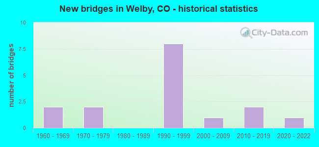
- New bridges - historical statistics
- 21960-1969
- 21970-1979
- 81990-1999
- 12000-2009
- 22010-2019
- 12020-2022
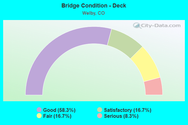
- Bridge Condition - Deck
- 58.3%Good
- 16.7%Satisfactory
- 16.7%Fair
- 8.3%Serious
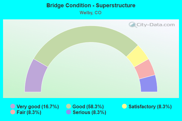
- Bridge Condition - Superstructure
- 16.7%Very good
- 58.3%Good
- 8.3%Satisfactory
- 8.3%Fair
- 8.3%Serious
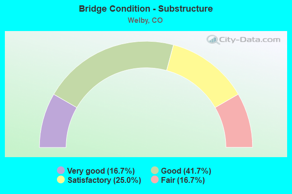
- Bridge Condition - Substructure
- 16.7%Very good
- 41.7%Good
- 25.0%Satisfactory
- 16.7%Fair
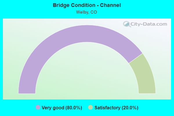
- Bridge Condition - Channel
- 80.0%Very good
- 20.0%Satisfactory
Find on map >> Show street view
Structure Number: ADA04.9-087, Location: 0.1 MI S OF 88TH AVE. (Lat: 39.854228, Lng: -104.959883), Route carried "on" structure: County highway , Year Built: 2017, Status: Open, Structure Length: 0.77m (2.53ft), Average Daily Traffic: 1,656 (year 2021), Average Future Daily Traffic: 2,153 (year 2041), Design Load: HL 93, Features Intersected: HOFFMAN DRAINAGE, Facility Carried by Structure: RAINBOW AVENUE
Minimum Vertical Clearance: 30+ m (98+ ft), Kilometerpoint: 0.624, Lanes on structure: 2, Owner: County Highway Agency, Approaching Roadway Width: 12.4m (40.7ft), Material/Design: Concrete, Design/Construction: Culvert, Number Of Spans In Main Unit: 3, Length of Maximum Span: 2.1m (6.9ft), Curb or Sidewalk Widths: Left: 6.9m (22.6ft), Right: 1.5m (4.9ft), Out-to-Out Width: 22.5m (73.8ft)
Condition: Channel: Very good, Culverts: Very good, Operating Rating: 45.0 metric tons, Method Used To Determine Operating Rating: Load and Resistance Factor Rating (LRFR) rating reported by rating factor(RF) method using HL-93 loadings, Inventory Rating: 34.7 metric tons, Method Used To Determine Inventory Rating: Load and Resistance Factor Rating (LRFR) rating reported by rating factor(RF) method using HL-93 loadings, Structural Evaluation: Equal to present desirable criteria, Waterway Adequacy: Equal to present desirable criteria, Approach Roadway Alignment: Equal to present desirable criteria, Designated Inspection Frequency: Every 24 months, Inspection Date: January 2022
Find on map >> Show street view
Structure Number: ADA05.2-086.1, Location: 0.2 MI S OF 88TH AVE. (Lat: 39.852600, Lng: -104.955592), Route carried "on" structure: County highway , Year Built: 2020, Status: Open, Structure Length: 0.91m (2.99ft), Average Daily Traffic: 8,171 (year 2021), Average Future Daily Traffic: 10,622 (year 2041), Design Load: HL 93, Features Intersected: HOFFMAN DRAINAGE, Facility Carried by Structure: DEVONSHIRE BLVD
Minimum Vertical Clearance: 30.45m (99.90ft), Kilometerpoint: 0.366, Lanes on structure: 3, Owner: County Highway Agency, Approaching Roadway Width: 20.6m (67.6ft), Material/Design: Concrete, Design/Construction: Culvert, Number Of Spans In Main Unit: 3, Length of Maximum Span: 2.7m (8.9ft), Curb or Sidewalk Widths: Left: 1.5m (4.9ft), Right: 0.0m, Out-to-Out Width: 42.1m (138.1ft)
Condition: Channel: Very good, Culverts: Very good, Operating Rating: 45.0 metric tons, Method Used To Determine Operating Rating: Load and Resistance Factor Rating (LRFR) rating reported by rating factor(RF) method using HL-93 loadings, Inventory Rating: 34.7 metric tons, Method Used To Determine Inventory Rating: Load and Resistance Factor Rating (LRFR) rating reported by rating factor(RF) method using HL-93 loadings, Structural Evaluation: Equal to present desirable criteria, Waterway Adequacy: Equal to present desirable criteria, Approach Roadway Alignment: Equal to present desirable criteria, Designated Inspection Frequency: Every 24 months, Inspection Date: January 2022
Find on map >> Show street view
Structure Number: ADA05.5-086, Location: INTERSECT STEELE/86TH (Lat: 39.852417, Lng: -104.949556), Route carried "on" structure: County highway , Year Built: 2017, Status: Open, Structure Length: 0.66m (2.17ft), Average Daily Traffic: 2,256 (year 2021), Average Future Daily Traffic: 2,933 (year 2041), Design Load: HL 93, Features Intersected: HOFFMAN DRAINAGE, Facility Carried by Structure: STEELE STREET
Minimum Vertical Clearance: 30.45m (99.90ft), Kilometerpoint: 1.621, Lanes on structure: 2, Owner: County Highway Agency, Approaching Roadway Width: 8.7m (28.5ft), Material/Design: Concrete, Design/Construction: Culvert, Number Of Spans In Main Unit: 2, Length of Maximum Span: 3.0m (9.8ft), Out-to-Out Width: 23.2m (76.1ft)
Condition: Channel: Very good, Culverts: Very good, Operating Rating: 45.7 metric tons, Method Used To Determine Operating Rating: Load and Resistance Factor Rating (LRFR) rating reported by rating factor(RF) method using HL-93 loadings, Inventory Rating: 35.3 metric tons, Method Used To Determine Inventory Rating: Load and Resistance Factor Rating (LRFR) rating reported by rating factor(RF) method using HL-93 loadings, Structural Evaluation: Equal to present desirable criteria, Waterway Adequacy: Equal to present desirable criteria, Approach Roadway Alignment: Equal to present minimum criteria, Designated Inspection Frequency: Every 24 months, Inspection Date: January 2022, Wearing Surface/Protective System: Wearing Surface: Bituminous
Find on map >> Show street view
Structure Number: ADA05N-072.4035, Location: 72ND AND YORK (Lat: 39.828272, Lng: -104.959175), Route carried "on" structure: County highway , Year Built: 1965, Status: Open, Structure Length: 4.42m (14.50ft), Average Daily Traffic: 13,608 (year 2021), Truck Traffic: 6%, Average Future Daily Traffic: 17,690 (year 2041), Features Intersected: CLEAR CREEK, Facility Carried by Structure: YORK STREET
Minimum Vertical Clearance: 30+ m (98+ ft), Kilometerpoint: 3.064, Lanes on structure: 5, Owner: County Highway Agency, Approaching Roadway Width: 19.5m (64.0ft), Material/Design: Prestressed concrete, Design/Construction: Tee Beam, Number Of Spans In Main Unit: 2, Length of Maximum Span: 21.1m (69.2ft), Curb or Sidewalk Widths: Left: 1.2m (3.9ft), Right: 1.2m (3.9ft), Curb-To-Curb Width: 19.5m (64.0ft), Out-to-Out Width: 22.7m (74.5ft)
Condition: Deck: Fair, Superstructure: Fair, Substructure: Fair, Channel: Satisfactory, Inventory Rating: 58.0 metric tons, Method Used To Determine Inventory Rating: Load Factor (LF), Structural Evaluation: Somewhat better than minimum adequacy, Deck Geometry: Meets minimum limits, Waterway Adequacy: Equal to present desirable criteria, Approach Roadway Alignment: Equal to present desirable criteria, Designated Inspection Frequency: Every 24 months, Inspection Date: January 2022, Deck Structure Type: Concrete Cast-file-Place, Wearing Surface/Protective System: Wearing Surface: Bituminous
Find on map >> Show street view
Structure Number: ADA4.2-081.6031, Location: DOWNING AT CORONADO PKWY (Lat: 39.845183, Lng: -104.973211), Route carried "on" structure: County highway , Year Built: 1965, Year Reconstructed: 2004, Status: Open, Structure Length: 0.69m (2.26ft), Average Daily Traffic: 2,510 (year 2021), Truck Traffic: 2%, Average Future Daily Traffic: 3,263 (year 2041), Features Intersected: NIVER CREEK, Facility Carried by Structure: DOWNING DRIVE
Minimum Vertical Clearance: 30+ m (98+ ft), Kilometerpoint: 0.336, Lanes on structure: 2, Owner: County Highway Agency, Approaching Roadway Width: 10.7m (35.1ft), Material/Design: Prestressed concrete, Design/Construction: Slab, Number Of Spans In Main Unit: 1, Length of Maximum Span: 6.1m (20.0ft), Curb or Sidewalk Widths: Left: 1.8m (5.9ft), Right: 1.8m (5.9ft), Curb-To-Curb Width: 10.1m (33.1ft), Out-to-Out Width: 14.9m (48.9ft)
Condition: Deck: Good, Superstructure: Good, Substructure: Satisfactory, Channel: Very good, Operating Rating: 36.3 metric tons, Method Used To Determine Operating Rating: Field evaluation and documented engineering judgment, Inventory Rating: 32.7 metric tons, Method Used To Determine Inventory Rating: Field evaluation and documented engineering judgment, Structural Evaluation: Equal to present minimum criteria, Deck Geometry: Meets minimum limits, Waterway Adequacy: Equal to present desirable criteria, Approach Roadway Alignment: Equal to present desirable criteria, Designated Inspection Frequency: Every 24 months, Inspection Date: January 2022, Deck Structure Type: Other, Wearing Surface/Protective System: Wearing Surface: Bituminous
Find on map >> Show street view
Structure Number: ADA4.5-081.2032, Location: NEAR CORONADO PKWY (Lat: 39.843256, Lng: -104.968714), Route carried "on" structure: County highway , Year Built: 1970, Status: Open, Structure Length: 1.17m (3.84ft), Average Daily Traffic: 1,764 (year 2021), Truck Traffic: 4%, Average Future Daily Traffic: 2,293 (year 2041), Features Intersected: NIVER CREEK, Facility Carried by Structure: EXPLORADOR CALLE
Minimum Vertical Clearance: 30+ m (98+ ft), Kilometerpoint: 0.806, Lanes on structure: 2, Owner: County Highway Agency, Approaching Roadway Width: 7.3m (24.0ft), Material/Design: Prestressed concrete, Design/Construction: Tee Beam, Number Of Spans In Main Unit: 1, Length of Maximum Span: 10.7m (35.1ft), Curb or Sidewalk Widths: Left: 1.4m (4.6ft), Right: 0.3m (1.0ft), Curb-To-Curb Width: 12.0m (39.4ft), Out-to-Out Width: 13.7m (44.9ft)
Condition: Deck: Serious, Superstructure: Serious, Substructure: Fair, Channel: Very good, Operating Rating: 32.7 metric tons, Method Used To Determine Operating Rating: Field evaluation and documented engineering judgment, Inventory Rating: 24.5 metric tons, Method Used To Determine Inventory Rating: Field evaluation and documented engineering judgment, Structural Evaluation: High priority of corrective action, Deck Geometry: Equal to present minimum criteria, Waterway Adequacy: Equal to present desirable criteria, Approach Roadway Alignment: Equal to present desirable criteria, Designated Inspection Frequency: Every 12 months, Inspection Date: January 2022, Deck Structure Type: Other, Wearing Surface/Protective System: Wearing Surface: Bituminous
Find on map >> Show street view
Structure Number: ADA5.5-78.90303, Location: 0.28 MI N of 78th PLACE (Lat: 39.841692, Lng: -104.950586), Route carried "on" structure: County highway , Year Built: 1999, Status: Open, Structure Length: 2.67m (8.76ft), Average Daily Traffic: 1,868 (year 2021), Truck Traffic: 10%, Average Future Daily Traffic: 2,428 (year 2041), Design Load: HS 25 or greater, Features Intersected: NIVER CREEK, Facility Carried by Structure: STEELE STREET
Minimum Vertical Clearance: 30+ m (98+ ft), Kilometerpoint: 0.362, Lanes on structure: 2, Owner: County Highway Agency, Approaching Roadway Width: 7.3m (24.0ft), Material/Design: Prestressed concrete, Design/Construction: Stringer/Multi-beam, Number Of Spans In Main Unit: 1, Length of Maximum Span: 25.1m (82.3ft), Curb-To-Curb Width: 11.0m (36.1ft), Out-to-Out Width: 11.7m (38.4ft)
Condition: Deck: Fair, Superstructure: Good, Substructure: Satisfactory, Channel: Very good, Operating Rating: 62.3 metric tons, Method Used To Determine Operating Rating: Load Factor (LF), Inventory Rating: 37.3 metric tons, Method Used To Determine Inventory Rating: Load Factor (LF), Structural Evaluation: Equal to present minimum criteria, Deck Geometry: Equal to present minimum criteria, Waterway Adequacy: Equal to present desirable criteria, Approach Roadway Alignment: Equal to present minimum criteria, Designated Inspection Frequency: Every 24 months, Inspection Date: January 2022, Deck Structure Type: Concrete Cast-file-Place, Wearing Surface/Protective System: Wearing Surface: Monolithic Concrete, Deck Protection: Epoxy Coated Reinforcing
Find on map >> Show street view
Structure Number: ADA79.2-05.0034, Location: YORK AND CORONADO PARKWAY (Lat: 39.841906, Lng: -104.959064), Route carried "on" structure: County highway , Year Built: 1970, Year Reconstructed: 2004, Status: Open, Structure Length: 1.26m (4.13ft), Average Daily Traffic: 9,770 (year 2021), Truck Traffic: 5%, Average Future Daily Traffic: 12,701 (year 2041), Design Load: HS 25 or greater, Features Intersected: NIVER CREEK, Facility Carried by Structure: YORK STREET
Minimum Vertical Clearance: 30+ m (98+ ft), Kilometerpoint: 4.580, Lanes on structure: 2, Owner: County Highway Agency, Approaching Roadway Width: 12.2m (40.0ft), Material/Design: Prestressed concrete, Design/Construction: Tee Beam, Number Of Spans In Main Unit: 1, Length of Maximum Span: 11.9m (39.0ft), Curb or Sidewalk Widths: Left: 2.4m (7.9ft), Right: 2.4m (7.9ft), Curb-To-Curb Width: 13.3m (43.6ft), Out-to-Out Width: 19.2m (63.0ft)
Condition: Deck: Good, Superstructure: Good, Substructure: Good, Channel: Very good, Operating Rating: 74.7 metric tons, Method Used To Determine Operating Rating: Load Factor (LF), Inventory Rating: 44.8 metric tons, Method Used To Determine Inventory Rating: Load Factor (LF), Structural Evaluation: Better than present minimum criteria, Deck Geometry: Somewhat better than minimum adequacy, Waterway Adequacy: Equal to present desirable criteria, Approach Roadway Alignment: Equal to present desirable criteria, Designated Inspection Frequency: Every 24 months, Inspection Date: January 2022, Deck Structure Type: Concrete Cast-file-Place, Wearing Surface/Protective System: Wearing Surface: Bituminous, Membrane: Built-up, Deck Protection: Epoxy Coated Reinforcing
Find on map >> Show street view
Structure Number: E-17-NW, Location: .2 MI N 76; .1 MI E I-25 (Lat: 39.821828, Lng: -104.980892), Route carried "on" structure: Ramp Interstate 25A, Year Built: 1992, Status: Open, Structure Length: 7.28m (23.88ft), Average Daily Traffic: 121,000 (year 2020), Truck Traffic: 10%, Average Future Daily Traffic: 141,570 (year 2040), Design Load: HS 20, Features Intersected: CLEAR CREEK R, Facility Carried by Structure: RAMP TO I 25 NBND
Minimum Vertical Clearance: 30+ m (98+ ft), Kilometerpoint: 1.286, Lanes on structure: 1, Base Highway Network: Yes, Owner: State Highway Agency, Approaching Roadway Width: 8.8m (28.9ft), Material/Design: Prestressed concrete continuous, Design/Construction: Box Beam or Girders - Single/Spread, Number Of Spans In Main Unit: 3, Length of Maximum Span: 24.4m (80.1ft), Curb-To-Curb Width: 8.8m (28.9ft), Out-to-Out Width: 9.8m (32.2ft)
Condition: Deck: Good, Superstructure: Very good, Substructure: Very good, Channel: Satisfactory, Operating Rating: 72.1 metric tons, Method Used To Determine Operating Rating: Load Factor (LF), Inventory Rating: 37.2 metric tons, Method Used To Determine Inventory Rating: Load Factor (LF), Structural Evaluation: Equal to present desirable criteria, Deck Geometry: Superior to present desirable criteria, Waterway Adequacy: Equal to present desirable criteria, Approach Roadway Alignment: Equal to present desirable criteria, Designated Inspection Frequency: Every 24 months, Inspection Date: June 2021, Deck Structure Type: Concrete Cast-file-Place, Wearing Surface/Protective System: Wearing Surface: Monolithic Concrete, Deck Protection: Epoxy Coated Reinforcing
Find on map >> Show street view
Structure Number: E-17-OO, Location: 70TH BTWN 76 AND 36 INTCH (Lat: 39.823711, Lng: -104.982633), Route carried "on" structure: State highway 224A, Year Built: 1991, Status: Open, Structure Length: 21.18m (69.49ft), Average Daily Traffic: 20,000 (year 2020), Truck Traffic: 5%, Average Future Daily Traffic: 23,400 (year 2040), Design Load: HS 20, Features Intersected: I 25 ML, Facility Carried by Structure: US 224 ML-70TH AVE
Minimum Vertical Clearance: 5.11m (16.77ft), Kilometerpoint: 0.813, Lanes on structure: 4, Lanes under structure: 17, Owner: State Highway Agency, Approaching Roadway Width: 19.8m (65.0ft), Material/Design: Steel continuous, Design/Construction: Box Beam or Girders - Single/Spread, Number Of Spans In Main Unit: 5, Length of Maximum Span: 51.4m (168.6ft), Curb or Sidewalk Widths: Left: 1.8m (5.9ft), Right: 0.0m, Curb-To-Curb Width: 20.4m (66.9ft), Out-to-Out Width: 31.4m (103.0ft)
Condition: Deck: Good, Superstructure: Good, Substructure: Good, Operating Rating: 67.2 metric tons, Method Used To Determine Operating Rating: Load Factor (LF), Inventory Rating: 35.4 metric tons, Method Used To Determine Inventory Rating: Load Factor (LF), Structural Evaluation: Better than present minimum criteria, Deck Geometry: Superior to present desirable criteria, Underclear: High priority of corrective action, Approach Roadway Alignment: Equal to present desirable criteria, Length Of Structure Improvement: 21.19m (69.52ft), Designated Inspection Frequency: Every 24 months, Inspection Date: June 2021, Bridge Improvement Cost: $2,578,000, Roadway Improvement Cost: $258,000, Total Project Cost: $3,868,000, Deck Structure Type: Concrete Cast-file-Place, Wearing Surface/Protective System: Wearing Surface: Bituminous, Membrane: Preformed Fabric, Deck Protection: Epoxy Coated Reinforcing
Find on map >> Show street view
Structure Number: E-17-PU, Location: MEDIAN I25 ML & SH 22 (Lat: 39.823339, Lng: -104.982964), Route carried "on" structure: Ramp Interstate 25A, Year Built: 1993, Status: Open, Structure Length: 4.76m (15.62ft), Average Daily Traffic: 242,000 (year 2020), Truck Traffic: 10%, Average Future Daily Traffic: 283,140 (year 2040), Design Load: HS 20, Features Intersected: I25 ACCESS, Facility Carried by Structure: HOV RAMP
Minimum Vertical Clearance: 30+ m (98+ ft), Kilometerpoint: 0.225, Lanes on structure: 2, Base Highway Network: Yes, Owner: State Highway Agency, Approaching Roadway Width: 8.5m (27.9ft), Material/Design: Prestressed concrete, Design/Construction: Box Beam or Girders - Multiple, Number Of Spans In Main Unit: 1, Length of Maximum Span: 46.0m (150.9ft), Curb-To-Curb Width: 8.5m (27.9ft), Out-to-Out Width: 9.5m (31.2ft)
Condition: Deck: Good, Superstructure: Very good, Substructure: Very good, Operating Rating: 74.0 metric tons, Method Used To Determine Operating Rating: Load Factor (LF), Inventory Rating: 44.5 metric tons, Method Used To Determine Inventory Rating: Load Factor (LF), Structural Evaluation: Equal to present desirable criteria, Deck Geometry: High priority of corrective action, Approach Roadway Alignment: Equal to present desirable criteria, Designated Inspection Frequency: Every 24 months, Inspection Date: June 2021, Deck Structure Type: Concrete Cast-file-Place, Wearing Surface/Protective System: Wearing Surface: Monolithic Concrete, Deck Protection: Epoxy Coated Reinforcing
Find on map >> Show street view
Structure Number: E-17-PY, Location: 74TH AVE 1.25 MI W OF 6/8 (Lat: 39.830697, Lng: -104.948997), Route carried "on" structure: State highway 224A, Year Built: 1993, Status: Open, Structure Length: 12.80m (41.99ft), Average Daily Traffic: 12,000 (year 2020), Truck Traffic: 8%, Average Future Daily Traffic: 12,600 (year 2040), Design Load: HS 20+Mod, Features Intersected: SOUTH PLATTE RIVER, Facility Carried by Structure: SH 224 ML
Minimum Vertical Clearance: 30+ m (98+ ft), Kilometerpoint: 3.956, Lanes on structure: 2, Owner: State Highway Agency, Approaching Roadway Width: 12.2m (40.0ft), Material/Design: Prestressed concrete continuous, Design/Construction: Stringer/Multi-beam, Number Of Spans In Main Unit: 4, Length of Maximum Span: 32.0m (105.0ft), Curb or Sidewalk Widths: Left: 2.4m (7.9ft), Right: 0.0m, Curb-To-Curb Width: 12.2m (40.0ft), Out-to-Out Width: 16.0m (52.5ft)
Condition: Deck: Good, Superstructure: Good, Substructure: Good, Channel: Very good, Operating Rating: 66.2 metric tons, Method Used To Determine Operating Rating: Allowable Stress (AS), Inventory Rating: 25.5 metric tons, Method Used To Determine Inventory Rating: Allowable Stress (AS), Structural Evaluation: Equal to present minimum criteria, Deck Geometry: Somewhat better than minimum adequacy, Waterway Adequacy: Equal to present desirable criteria, Approach Roadway Alignment: Equal to present desirable criteria, Designated Inspection Frequency: Every 24 months, Inspection Date: December 2021, Deck Structure Type: Concrete Cast-file-Place, Wearing Surface/Protective System: Wearing Surface: Monolithic Concrete, Deck Protection: Epoxy Coated Reinforcing
Find on map >> Show street view
Structure Number: E-17-QH, Location: JUST EAST OF I-25 ramp; U (Lat: 39.827325, Lng: -104.978364), Route carried "on" structure: Interstate 270B, Year Built: 2003, Status: Open, Structure Length: 5.25m (17.22ft), Average Daily Traffic: 37,500 (year 2020), Truck Traffic: 14%, Average Future Daily Traffic: 47,250 (year 2040), Design Load: HS 25 or greater, Features Intersected: WASHINGTON STREET, Facility Carried by Structure: I 270 EBND ML
Minimum Vertical Clearance: 30+ m (98+ ft), Kilometerpoint: 0.037, Lanes on structure: 4, Lanes under structure: 6, Base Highway Network: Yes, Owner: State Highway Agency, Approaching Roadway Width: 25.0m (82.0ft), Material/Design: Prestressed concrete, Design/Construction: Box Beam or Girders - Single/Spread, Number Of Spans In Main Unit: 1, Length of Maximum Span: 51.8m (169.9ft), Curb-To-Curb Width: 25.0m (82.0ft), Out-to-Out Width: 25.9m (85.0ft)
Condition: Deck: Satisfactory, Superstructure: Good, Substructure: Good, Operating Rating: 45.4 metric tons, Method Used To Determine Operating Rating: Load and Resistance Factor Rating (LRFR) rating reported by rating factor(RF) method using HL-93 loadings, Inventory Rating: 22.7 metric tons, Method Used To Determine Inventory Rating: Load and Resistance Factor Rating (LRFR) rating reported by rating factor(RF) method using HL-93 loadings, Structural Evaluation: Somewhat better than minimum adequacy, Deck Geometry: Superior to present desirable criteria, Underclear: Meets minimum limits, Approach Roadway Alignment: Equal to present desirable criteria, Designated Inspection Frequency: Every 24 months, Inspection Date: September 2020, Deck Structure Type: Concrete Cast-file-Place, Wearing Surface/Protective System: Wearing Surface: Monolithic Concrete, Deck Protection: Epoxy Coated Reinforcing
Find on map >> Show street view
Structure Number: E-17-QO, Location: 0.3 MI E. OF I 25 (Lat: 39.827831, Lng: -104.978356), Route carried "on" structure: Interstate 270B, Year Built: 1998, Status: Open, Structure Length: 5.58m (18.31ft), Average Daily Traffic: 37,500 (year 2020), Truck Traffic: 14%, Average Future Daily Traffic: 47,250 (year 2040), Design Load: HS 20, Features Intersected: WASHINGTON STREET, Facility Carried by Structure: I 270 ML WBND
Minimum Vertical Clearance: 30+ m (98+ ft), Kilometerpoint: 0.039, Lanes on structure: 3, Lanes under structure: 6, Base Highway Network: Yes, Owner: State Highway Agency, Approaching Roadway Width: 20.4m (66.9ft), Material/Design: Prestressed concrete, Design/Construction: Box Beam or Girders - Single/Spread, Number Of Spans In Main Unit: 1, Length of Maximum Span: 55.0m (180.4ft), Curb-To-Curb Width: 20.4m (66.9ft), Out-to-Out Width: 21.3m (69.9ft)
Condition: Deck: Satisfactory, Superstructure: Satisfactory, Substructure: Satisfactory, Operating Rating: 55.2 metric tons, Method Used To Determine Operating Rating: Load Factor (LF), Inventory Rating: 33.1 metric tons, Method Used To Determine Inventory Rating: Load Factor (LF), Structural Evaluation: Equal to present minimum criteria, Deck Geometry: Superior to present desirable criteria, Underclear: Meets minimum limits, Approach Roadway Alignment: Equal to present desirable criteria, Designated Inspection Frequency: Every 24 months, Inspection Date: September 2020, Deck Structure Type: Concrete Cast-file-Place, Wearing Surface/Protective System: Wearing Surface: Monolithic Concrete, Deck Protection: Epoxy Coated Reinforcing
Find on map >> Show street view
Structure Number: E-17-VT, Location: I 25 NBND & SH 224 (Lat: 39.823431, Lng: -104.981836), Route carried "on" structure: Ramp Interstate 25A, Year Built: 1998, Status: Open, Structure Length: 4.24m (13.91ft), Average Daily Traffic: 242,000 (year 2020), Truck Traffic: 10%, Average Future Daily Traffic: 283,140 (year 2040), Design Load: HS 20+Mod, Features Intersected: HOV RAMP R, Facility Carried by Structure: I 25 RAMP
Minimum Vertical Clearance: 30+ m (98+ ft), Kilometerpoint: 0.341, Lanes on structure: 2, Base Highway Network: Yes, Owner: State Highway Agency, Approaching Roadway Width: 11.3m (37.1ft), Material/Design: Prestressed concrete, Design/Construction: Box Beam or Girders - Multiple, Number Of Spans In Main Unit: 1, Length of Maximum Span: 41.0m (134.5ft), Curb-To-Curb Width: 11.4m (37.4ft), Out-to-Out Width: 12.3m (40.4ft)
Condition: Deck: Good, Superstructure: Good, Substructure: Good, Operating Rating: 32.4 metric tons, Method Used To Determine Operating Rating: Load and Resistance Factor Rating (LRFR) rating reported by rating factor(RF) method using HL-93 loadings, Inventory Rating: 6.5 metric tons, Method Used To Determine Inventory Rating: Load and Resistance Factor Rating (LRFR) rating reported by rating factor(RF) method using HL-93 loadings, Structural Evaluation: High priority of corrective action, Deck Geometry: Superior to present desirable criteria, Approach Roadway Alignment: Equal to present desirable criteria, Designated Inspection Frequency: Every 24 months, Inspection Date: June 2021, Deck Structure Type: Concrete Cast-file-Place, Wearing Surface/Protective System: Wearing Surface: Monolithic Concrete, Deck Protection: Epoxy Coated Reinforcing
Find on map >> Show street view
Structure Number: E-17-OO, Location: 70TH BTWN 76 AND 36 INTCH (Lat: 39.823711, Lng: -104.982633), Route carried "under" structure: Interstate 25A, Year Built: 1991, Structure Length: 0. m, Average Daily Traffic: 235,000 (year 2011), Truck Traffic: 10%, Features Intersected: I 25 ML, Facility Carried by Structure: US 224 ML-70TH AVE
Minimum Vertical Clearance: 5.11m (16.77ft), Kilometerpoint: 348.783, Lanes on structure: 4, Lanes under structure: 17, Material/Design: Steel continuous, Design/Construction: Box Beam or Girders - Single/Spread, Length of Maximum Span: 51.4m (168.6ft)