Bridge Statistics for Weirton, West Virginia (WV)
Condition, Traffic, Stress, Structural Evaluation, Project Costs
- National Bridge Inventory (NBI) Statistics
- 51Number of bridges
- 1,171ft / 357mTotal length
- $12,692,000Total costs
- 462,847Total average daily traffic
- 42,897Total average daily truck traffic
- National Bridge Inventory (NBI) Registered Bridges for Weirton
- No street view available for this location
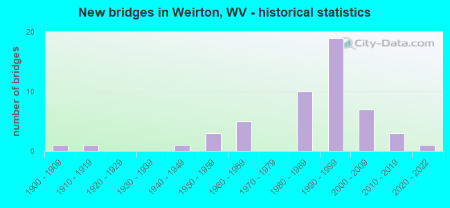
- New bridges - historical statistics
- 11900-1909
- 11910-1919
- 11940-1949
- 31950-1959
- 51960-1969
- 101980-1989
- 191990-1999
- 72000-2009
- 32010-2019
- 12020-2022


- Bridge Condition - Deck
- 3.4%Excellent
- 55.2%Good
- 20.7%Satisfactory
- 17.2%Fair
- 3.4%Poor

- Bridge Condition - Superstructure
- 3.3%Excellent
- 50.0%Good
- 23.3%Satisfactory
- 16.7%Fair
- 6.7%Poor

- Bridge Condition - Substructure
- 3.4%Excellent
- 34.5%Good
- 10.3%Satisfactory
- 34.5%Fair
- 17.2%Poor

- Bridge Condition - Channel
- 11.1%Excellent
- 16.7%Very good
- 27.8%Good
- 22.2%Satisfactory
- 16.7%Fair
- 5.6%Poor
Find on map >> Show street view
Structure Number: 5A051, Location: 0.11 mi. South jct CR1 (Lat: 40.389769, Lng: -80.568800), Route carried "on" structure: County highway 13, Year Built: 1912, Status: Posted for load, Structure Length: 1.98m (6.50ft), Average Daily Traffic: 700 (year 2020), Truck Traffic: 3%, Average Future Daily Traffic: 1,043 (year 2040), Features Intersected: Harmon Creek, Facility Carried by Structure: County Route 1/3
Minimum Vertical Clearance: 30+ m (98+ ft), Kilometerpoint: 0.467, Lanes on structure: 1, Owner: State Highway Agency, Approaching Roadway Width: 4.6m (15.1ft), Material/Design: Concrete, Design/Construction: Arch - Deck, Number Of Spans In Main Unit: 1, Length of Maximum Span: 18.3m (60.0ft), Curb-To-Curb Width: 4.1m (13.5ft), Out-to-Out Width: 4.9m (16.1ft)
Condition: Superstructure: Poor, Channel: Fair, Operating Rating: 23.6 metric tons, Method Used To Determine Operating Rating: Field evaluation and documented engineering judgment, Inventory Rating: 10.0 metric tons, Method Used To Determine Inventory Rating: Field evaluation and documented engineering judgment, Structural Evaluation: High priority of replacement, Deck Geometry: High priority of replacement, Waterway Adequacy: Better than present minimum criteria, Approach Roadway Alignment: Equal to present minimum criteria, Bridge Posting: Required (Relationship of Operating Rating to Maximum Legal Load: 30.0 - 39.9% below), Length Of Structure Improvement: 2.77m (9.09ft), Designated Inspection Frequency: Every 24 months, Inspection Date: September 2021, Bridge Improvement Cost: $195,000, Roadway Improvement Cost: $191,000, Total Project Cost: $569,000 ( Estimate for 2019), Deck Structure Type: Concrete Cast-file-Place, Wearing Surface/Protective System: Wearing Surface: Bituminous
Find on map >> Show street view
Structure Number: 5A052, Location: 0.01 mi. West jct WV 2 (Lat: 40.379561, Lng: -80.605161), Route carried "on" structure: Ramp US 22, Year Built: 1984, Status: Open, Structure Length: 12.97m (42.55ft), Average Daily Traffic: 5,617 (year 2018), Truck Traffic: 11%, Average Future Daily Traffic: 8,538 (year 2038), Design Load: HS 20, Features Intersected: Railroad
Minimum Vertical Clearance: 30+ m (98+ ft), Kilometerpoint: 0.789, Lanes on structure: 1, Owner: State Highway Agency, Approaching Roadway Width: 8.5m (27.9ft), Skew: 9 degrees, Material/Design: Steel continuous, Design/Construction: Stringer/Multi-beam, Number Of Spans In Main Unit: 1, Number Of Approach Spans: 3, Length of Maximum Span: 38.3m (125.7ft), Curb-To-Curb Width: 8.5m (27.9ft), Out-to-Out Width: 9.5m (31.2ft)
Condition: Deck: Good, Superstructure: Satisfactory, Substructure: Good, Operating Rating: 88.9 metric tons, Method Used To Determine Operating Rating: Load Factor (LF), Inventory Rating: 62.6 metric tons, Method Used To Determine Inventory Rating: Load Factor (LF), Structural Evaluation: Equal to present minimum criteria, Deck Geometry: Superior to present desirable criteria, Underclear: Equal to present minimum criteria, Approach Roadway Alignment: Equal to present minimum criteria, Length Of Structure Improvement: 12.98m (42.59ft), Designated Inspection Frequency: Every 24 months, Inspection Date: Febuary 2020, Bridge Improvement Cost: $358,000, Total Project Cost: $358,000 ( Estimate for 2020), Deck Structure Type: Concrete Cast-file-Place, Wearing Surface/Protective System: Wearing Surface: Monolithic Concrete, Deck Protection: Epoxy Coated Reinforcing
Find on map >> Show street view
Structure Number: 5A054, Location: 0.09 mi. West jct WV 2 (Lat: 40.381769, Lng: -80.605150), Route carried "on" structure: US 22, Year Built: 1984, Status: Open, Structure Length: 18.11m (59.42ft), Average Daily Traffic: 34,200 (year 2019), Truck Traffic: 11%, Average Future Daily Traffic: 41,724 (year 2039), Design Load: HS 20, Features Intersected: Ramp D, Railroad
Minimum Vertical Clearance: 5.56m (18.24ft), Kilometerpoint: 0.708, Lanes on structure: 4, Lanes under structure: 2, Base Highway Network: Yes, Owner: State Highway Agency, Approaching Roadway Width: 22.9m (75.1ft), Skew: 36 degrees, Material/Design: Steel continuous, Design/Construction: Stringer/Multi-beam, Number Of Spans In Main Unit: 1, Number Of Approach Spans: 2, Length of Maximum Span: 65.5m (214.9ft), Curb or Sidewalk Widths: Left: 0.2m (0.7ft), Right: 0.2m (0.7ft), Curb-To-Curb Width: 23.0m (75.5ft), Out-to-Out Width: 25.1m (82.3ft)
Condition: Deck: Fair, Superstructure: Fair, Substructure: Poor, Operating Rating: 84.4 metric tons, Method Used To Determine Operating Rating: Load Factor (LF), Inventory Rating: 50.8 metric tons, Method Used To Determine Inventory Rating: Load Factor (LF), Structural Evaluation: Meets minimum limits, Deck Geometry: Equal to present minimum criteria, Underclear: Somewhat better than minimum adequacy, Approach Roadway Alignment: Equal to present desirable criteria, Length Of Structure Improvement: 18.11m (59.42ft), Designated Inspection Frequency: Every 24 months, Inspection Date: June 2020, Bridge Improvement Cost: $1,408,000, Total Project Cost: $1,408,000 ( Estimate for 2018), Deck Structure Type: Concrete Cast-file-Place, Wearing Surface/Protective System: Wearing Surface: Monolithic Concrete, Deck Protection: Epoxy Coated Reinforcing
Find on map >> Show street view
Structure Number: 5A055, Location: 0.01 mi. West jct WV 2 (Lat: 40.381881, Lng: -80.605019), Route carried "on" structure: Ramp US 22, Year Built: 1984, Status: Open, Structure Length: 15.19m (49.84ft), Average Daily Traffic: 4,213 (year 2018), Truck Traffic: 11%, Average Future Daily Traffic: 5,140 (year 2038), Design Load: HS 20, Features Intersected: US Route 22 & WV 2 SB
Minimum Vertical Clearance: 30+ m (98+ ft), Kilometerpoint: 0.950, Lanes on structure: 1, Lanes under structure: 2, Owner: State Highway Agency, Approaching Roadway Width: 8.5m (27.9ft), Skew: 9 degrees, Material/Design: Steel continuous, Design/Construction: Stringer/Multi-beam, Number Of Spans In Main Unit: 1, Number Of Approach Spans: 4, Length of Maximum Span: 36.6m (120.1ft), Curb or Sidewalk Widths: Left: 0.2m (0.7ft), Right: 0.2m (0.7ft), Curb-To-Curb Width: 8.5m (27.9ft), Out-to-Out Width: 9.5m (31.2ft)
Condition: Deck: Good, Superstructure: Good, Substructure: Fair, Operating Rating: 88.9 metric tons, Method Used To Determine Operating Rating: Load Factor (LF), Inventory Rating: 79.8 metric tons, Method Used To Determine Inventory Rating: Load Factor (LF), Structural Evaluation: Somewhat better than minimum adequacy, Deck Geometry: Superior to present desirable criteria, Underclear: Somewhat better than minimum adequacy, Approach Roadway Alignment: Equal to present minimum criteria, Length Of Structure Improvement: 15.21m (49.90ft), Designated Inspection Frequency: Every 24 months, Inspection Date: Febuary 2020, Bridge Improvement Cost: $419,000, Total Project Cost: $419,000 ( Estimate for 2020), Deck Structure Type: Concrete Cast-file-Place, Wearing Surface/Protective System: Wearing Surface: Monolithic Concrete, Deck Protection: Epoxy Coated Reinforcing
Find on map >> Show street view
Structure Number: 5A056, Location: 0.16 mi. North jct US 22 (Lat: 40.388669, Lng: -80.595939), Route carried "on" structure: Ramp State highway 2, Year Built: 1988, Status: Open, Structure Length: 16.23m (53.25ft), Average Daily Traffic: 5,900 (year 2019), Truck Traffic: 5%, Average Future Daily Traffic: 8,986 (year 2039), Design Load: HS 25 or greater, Features Intersected: Mittal Steel & NS RR
Minimum Vertical Clearance: 30+ m (98+ ft), Kilometerpoint: 0.290, Lanes on structure: 2, Owner: State Highway Agency, Approaching Roadway Width: 9.8m (32.2ft), Skew: 9 degrees, Material/Design: Steel continuous, Design/Construction: Stringer/Multi-beam, Number Of Spans In Main Unit: 1, Number Of Approach Spans: 4, Length of Maximum Span: 41.1m (134.8ft), Curb or Sidewalk Widths: Left: 0.2m (0.7ft), Right: 0.2m (0.7ft), Curb-To-Curb Width: 9.3m (30.5ft), Out-to-Out Width: 10.5m (34.4ft)
Condition: Deck: Satisfactory, Superstructure: Fair, Substructure: Fair, Operating Rating: 81.6 metric tons, Method Used To Determine Operating Rating: Load Factor (LF), Inventory Rating: 49.0 metric tons, Method Used To Determine Inventory Rating: Load Factor (LF), Structural Evaluation: Somewhat better than minimum adequacy, Deck Geometry: Somewhat better than minimum adequacy, Underclear: Somewhat better than minimum adequacy, Approach Roadway Alignment: Equal to present desirable criteria, Length Of Structure Improvement: 16.22m (53.22ft), Designated Inspection Frequency: Every 24 months, Inspection Date: June 2020, Bridge Improvement Cost: $495,000, Total Project Cost: $495,000 ( Estimate for 2018), Deck Structure Type: Concrete Cast-file-Place, Wearing Surface/Protective System: Wearing Surface: Monolithic Concrete, Deck Protection: Epoxy Coated Reinforcing
Find on map >> Show street view
Structure Number: 5A057, Location: 0.01 Mi. South Jct CR 507 (Lat: 40.390689, Lng: -80.594711), Route carried "on" structure: Ramp State highway 2, Year Built: 1988, Status: Open, Structure Length: 4.84m (15.88ft), Average Daily Traffic: 5,900 (year 2019), Truck Traffic: 5%, Average Future Daily Traffic: 7,965 (year 2039), Design Load: HS 25 or greater, Features Intersected: Harmon Creek
Minimum Vertical Clearance: 30+ m (98+ ft), Kilometerpoint: 0.048, Lanes on structure: 2, Owner: State Highway Agency, Approaching Roadway Width: 9.1m (29.9ft), Skew: 5 degrees, Material/Design: Steel continuous, Design/Construction: Stringer/Multi-beam, Number Of Spans In Main Unit: 1, Number Of Approach Spans: 2, Length of Maximum Span: 18.4m (60.4ft), Curb or Sidewalk Widths: Left: 0.2m (0.7ft), Right: 0.2m (0.7ft), Curb-To-Curb Width: 9.4m (30.8ft), Out-to-Out Width: 10.5m (34.4ft)
Condition: Deck: Satisfactory, Superstructure: Satisfactory, Substructure: Satisfactory, Channel: Very good, Operating Rating: 81.6 metric tons, Method Used To Determine Operating Rating: Load Factor (LF), Inventory Rating: 49.0 metric tons, Method Used To Determine Inventory Rating: Load Factor (LF), Structural Evaluation: Equal to present minimum criteria, Deck Geometry: Somewhat better than minimum adequacy, Waterway Adequacy: Equal to present minimum criteria, Approach Roadway Alignment: Equal to present desirable criteria, Length Of Structure Improvement: 4.85m (15.91ft), Designated Inspection Frequency: Every 24 months, Inspection Date: May 2020, Bridge Improvement Cost: $148,000, Total Project Cost: $148,000 ( Estimate for 2020), Deck Structure Type: Concrete Cast-file-Place, Wearing Surface/Protective System: Wearing Surface: Monolithic Concrete, Deck Protection: Epoxy Coated Reinforcing
Find on map >> Show street view
Structure Number: 5A058, Location: 0.01 mi. East jct WV2 (Lat: 40.391011, Lng: -80.594000), Route carried "on" structure: County highway 217, Year Built: 1988, Status: Open, Structure Length: 2.20m (7.22ft), Average Daily Traffic: 50 (year 2019), Truck Traffic: 8%, Average Future Daily Traffic: 61 (year 2039), Design Load: HS 25 or greater, Features Intersected: Harmon Creek, Facility Carried by Structure: County Route 2/17
Minimum Vertical Clearance: 30+ m (98+ ft), Kilometerpoint: 0.016, Lanes on structure: 3, Owner: State Highway Agency, Approaching Roadway Width: 12.8m (42.0ft), Skew: 1 degrees, Material/Design: Steel continuous, Design/Construction: Stringer/Multi-beam, Number Of Spans In Main Unit: 2, Length of Maximum Span: 10.4m (34.1ft), Curb or Sidewalk Widths: Left: 0.2m (0.7ft), Right: 0.2m (0.7ft), Curb-To-Curb Width: 13.1m (43.0ft), Out-to-Out Width: 13.9m (45.6ft)
Condition: Deck: Good, Superstructure: Satisfactory, Substructure: Good, Channel: Satisfactory, Operating Rating: 82.5 metric tons, Method Used To Determine Operating Rating: Load Factor (LF), Inventory Rating: 49.0 metric tons, Method Used To Determine Inventory Rating: Load Factor (LF), Structural Evaluation: Equal to present minimum criteria, Deck Geometry: Meets minimum limits, Waterway Adequacy: Equal to present desirable criteria, Approach Roadway Alignment: Equal to present minimum criteria, Length Of Structure Improvement: 2.19m (7.19ft), Designated Inspection Frequency: Every 24 months, Inspection Date: October 2020, Bridge Improvement Cost: $50,000, Total Project Cost: $50,000 ( Estimate for 2020), Deck Structure Type: Concrete Cast-file-Place, Wearing Surface/Protective System: Wearing Surface: Monolithic Concrete, Deck Protection: Epoxy Coated Reinforcing
Find on map >> Show street view
Structure Number: 5A059, Location: 0.05 mi. South jct CR2/17 (Lat: 40.390769, Lng: -80.594469), Route carried "on" structure: State highway 2, Year Built: 1988, Status: Open, Structure Length: 4.21m (13.81ft), Average Daily Traffic: 16,800 (year 2019), Truck Traffic: 5%, Average Future Daily Traffic: 25,536 (year 2039), Design Load: HS 25 or greater, Features Intersected: Harmon Creek
Minimum Vertical Clearance: 30+ m (98+ ft), Kilometerpoint: 26.136, Lanes on structure: 3, Base Highway Network: Yes, Owner: State Highway Agency, Approaching Roadway Width: 14.6m (47.9ft), Skew: 4 degrees, Material/Design: Steel continuous, Design/Construction: Stringer/Multi-beam, Number Of Spans In Main Unit: 1, Number Of Approach Spans: 2, Length of Maximum Span: 15.9m (52.2ft), Curb-To-Curb Width: 13.0m (42.7ft), Out-to-Out Width: 14.1m (46.3ft)
Condition: Deck: Fair, Superstructure: Good, Substructure: Satisfactory, Channel: Satisfactory, Operating Rating: 80.7 metric tons, Method Used To Determine Operating Rating: Load Factor (LF), Inventory Rating: 48.1 metric tons, Method Used To Determine Inventory Rating: Load Factor (LF), Structural Evaluation: Equal to present minimum criteria, Deck Geometry: Meets minimum limits, Waterway Adequacy: Equal to present minimum criteria, Approach Roadway Alignment: Meets minimum limits, Length Of Structure Improvement: 4.21m (13.81ft), Designated Inspection Frequency: Every 24 months, Inspection Date: October 2020, Bridge Improvement Cost: $178,000, Total Project Cost: $178,000 ( Estimate for 2016), Deck Structure Type: Concrete Cast-file-Place, Wearing Surface/Protective System: Wearing Surface: Monolithic Concrete, Deck Protection: Epoxy Coated Reinforcing
Find on map >> Show street view
Structure Number: 5A06, Location: At Ohio State Line (Lat: 40.377789, Lng: -80.610250), Route carried "on" structure: US 22, Year Built: 1990, Status: Open, Structure Length: 59.88m (196.46ft), Average Daily Traffic: 33,960 (year 2017), Truck Traffic: 11%, Average Future Daily Traffic: 51,619 (year 2037), Design Load: HS 20, Features Intersected: OHIO RIVER & OHIO RT 7
Minimum Vertical Clearance: 5.18m (16.99ft), Kilometerpoint: 0.016, Lanes on structure: 6, Lanes under structure: 4, Base Highway Network: Yes, Owner: State Highway Agency, Approaching Roadway Width: 29.0m (95.1ft), Skew: 30 degrees, Navigation Control: Yes ( Vertical Clearance: 21.0m (68.9ft), Horizontal Clearance: 243.8m (799.9ft)), Material/Design: Steel continuous, Design/Construction: Stayed Girder, Number Of Spans In Main Unit: 1, Number Of Approach Spans: 5, Length of Maximum Span: 249.9m (819.9ft), Curb or Sidewalk Widths: Left: 0.2m (0.7ft), Right: 0.2m (0.7ft), Curb-To-Curb Width: 24.7m (81.0ft), Out-to-Out Width: 28.0m (91.9ft)
Condition: Deck: Satisfactory, Superstructure: Fair, Substructure: Fair, Channel: Good, Operating Rating: 49.0 metric tons, Method Used To Determine Operating Rating: Load Factor (LF), Inventory Rating: 31.7 metric tons, Method Used To Determine Inventory Rating: Load Factor (LF), Structural Evaluation: Somewhat better than minimum adequacy, Deck Geometry: Meets minimum limits, Underclear: Meets minimum limits, Waterway Adequacy: Superior to present desirable criteria, Approach Roadway Alignment: Equal to present desirable criteria, Length Of Structure Improvement: 59.89m (196.49ft), Designated Inspection Frequency: Every 24 months, Critical Feature Inspection Frequency: Every 12 months, Underwater Inspection Frequency: Every 60 months, Other Special Inspection Frequency: Every 12 months, Inspection Date: October 2020, Critical Feature Inspection Date: October 2021, Underwater Inspection Date: August 2020, Other Special Inspection Date: October 2021, Bridge Improvement Cost: $2,330,000, Roadway Improvement Cost: $464,000, Total Project Cost: $2,797,000 ( Estimate for 2017), Deck Structure Type: Concrete Cast-file-Place, Wearing Surface/Protective System: Wearing Surface: Monolithic Concrete, Deck Protection: Epoxy Coated Reinforcing
Find on map >> Show street view
Structure Number: 5A064, Location: 2.11 mi. East OHIO LINE (Lat: 40.388450, Lng: -80.594400), Route carried "on" structure: State highway 2, Year Built: 1993, Status: Open, Structure Length: 21.92m (71.92ft), Average Daily Traffic: 11,200 (year 2020), Truck Traffic: 5%, Average Future Daily Traffic: 17,024 (year 2040), Design Load: HS 25 or greater, Features Intersected: US 22 & Ramp G
Minimum Vertical Clearance: 30+ m (98+ ft), Kilometerpoint: 25.862, Lanes on structure: 2, Lanes under structure: 2, Base Highway Network: Yes, Owner: State Highway Agency, Approaching Roadway Width: 11.0m (36.1ft), Skew: 9 degrees, Material/Design: Steel continuous, Design/Construction: Stringer/Multi-beam, Number Of Spans In Main Unit: 1, Number Of Approach Spans: 7, Length of Maximum Span: 39.6m (129.9ft), Curb or Sidewalk Widths: Left: 0.2m (0.7ft), Right: 0.2m (0.7ft), Curb-To-Curb Width: 10.3m (33.8ft), Out-to-Out Width: 11.4m (37.4ft)
Condition: Deck: Good, Superstructure: Good, Substructure: Fair, Operating Rating: 59.0 metric tons, Method Used To Determine Operating Rating: Load Factor (LF), Inventory Rating: 35.4 metric tons, Method Used To Determine Inventory Rating: Load Factor (LF), Structural Evaluation: Somewhat better than minimum adequacy, Deck Geometry: Meets minimum limits, Underclear: Somewhat better than minimum adequacy, Approach Roadway Alignment: Equal to present minimum criteria, Length Of Structure Improvement: 21.92m (71.92ft), Designated Inspection Frequency: Every 24 months, Inspection Date: June 2021, Bridge Improvement Cost: $733,000, Total Project Cost: $733,000 ( Estimate for 2021), Deck Structure Type: Concrete Cast-file-Place, Wearing Surface/Protective System: Wearing Surface: Monolithic Concrete, Deck Protection: Epoxy Coated Reinforcing
Find on map >> Show street view
Structure Number: 5A065, Location: 0.06 mi. West jct WV2 (Lat: 40.388211, Lng: -80.595681), Route carried "on" structure: Ramp US 22, Year Built: 1993, Status: Open, Structure Length: 16.48m (54.07ft), Average Daily Traffic: 22,100 (year 2020), Truck Traffic: 11%, Average Future Daily Traffic: 33,592 (year 2040), Design Load: HS 25 or greater, Features Intersected: US 22
Minimum Vertical Clearance: 4.90m (16.08ft), Kilometerpoint: 1.819, Lanes on structure: 1, Lanes under structure: 4, Owner: State Highway Agency, Approaching Roadway Width: 6.7m (22.0ft), Skew: 39 degrees, Material/Design: Steel continuous, Design/Construction: Stringer/Multi-beam, Number Of Spans In Main Unit: 1, Number Of Approach Spans: 5, Length of Maximum Span: 31.2m (102.4ft), Curb or Sidewalk Widths: Left: 0.2m (0.7ft), Right: 0.2m (0.7ft), Curb-To-Curb Width: 6.9m (22.6ft), Out-to-Out Width: 8.0m (26.2ft)
Condition: Deck: Good, Superstructure: Satisfactory, Substructure: Poor, Operating Rating: 54.4 metric tons, Method Used To Determine Operating Rating: Load Factor (LF), Inventory Rating: 32.7 metric tons, Method Used To Determine Inventory Rating: Load Factor (LF), Structural Evaluation: Meets minimum limits, Deck Geometry: Somewhat better than minimum adequacy, Underclear: High priority of corrective action, Approach Roadway Alignment: Somewhat better than minimum adequacy, Length Of Structure Improvement: 16.46m (54.00ft), Designated Inspection Frequency: Every 24 months, Inspection Date: August 2021, Bridge Improvement Cost: $240,000, Total Project Cost: $240,000 ( Estimate for 2021), Deck Structure Type: Concrete Cast-file-Place, Wearing Surface/Protective System: Wearing Surface: Monolithic Concrete, Deck Protection: Epoxy Coated Reinforcing
Find on map >> Show street view
Structure Number: 5A066, Location: 0.17 mi. East jct WV2 (Lat: 40.389189, Lng: -80.593981), Route carried "on" structure: Ramp US 22, Year Built: 1993, Status: Open, Structure Length: 9.09m (29.82ft), Average Daily Traffic: 16,700 (year 2019), Truck Traffic: 10%, Average Future Daily Traffic: 25,384 (year 2039), Design Load: HS 25 or greater, Features Intersected: NS & Arcelor Mittal RR
Minimum Vertical Clearance: 30+ m (98+ ft), Kilometerpoint: 2.189, Lanes on structure: 1, Owner: State Highway Agency, Approaching Roadway Width: 7.0m (23.0ft), Skew: 9 degrees, Material/Design: Steel continuous, Design/Construction: Stringer/Multi-beam, Number Of Spans In Main Unit: 1, Number Of Approach Spans: 4, Length of Maximum Span: 21.7m (71.2ft), Curb-To-Curb Width: 6.9m (22.6ft), Out-to-Out Width: 8.0m (26.2ft)
Condition: Deck: Good, Superstructure: Good, Substructure: Good, Operating Rating: 78.9 metric tons, Method Used To Determine Operating Rating: Load Factor (LF), Inventory Rating: 47.2 metric tons, Method Used To Determine Inventory Rating: Load Factor (LF), Structural Evaluation: Better than present minimum criteria, Deck Geometry: Equal to present minimum criteria, Underclear: Meets minimum limits, Approach Roadway Alignment: Equal to present minimum criteria, Length Of Structure Improvement: 15.18m (49.80ft), Designated Inspection Frequency: Every 24 months, Inspection Date: August 2021, Bridge Improvement Cost: $224,000, Total Project Cost: $224,000 ( Estimate for 2019), Deck Structure Type: Concrete Cast-file-Place, Wearing Surface/Protective System: Wearing Surface: Monolithic Concrete, Deck Protection: Epoxy Coated Reinforcing
Find on map >> Show street view
Structure Number: 5A067, Location: 0.15 mi. West jct CR1 (Lat: 40.394631, Lng: -80.568400), Route carried "on" structure: US 22, Year Built: 1993, Status: Open, Structure Length: 23.76m (77.95ft), Average Daily Traffic: 34,200 (year 2019), Truck Traffic: 11%, Average Future Daily Traffic: 51,984 (year 2039), Design Load: HS 25 or greater, Features Intersected: Harmon Creek, CR1, CR1/3
Minimum Vertical Clearance: 30+ m (98+ ft), Kilometerpoint: 4.860, Lanes on structure: 4, Lanes under structure: 2, Base Highway Network: Yes, Owner: State Highway Agency, Approaching Roadway Width: 13.1m (43.0ft), Skew: 32 degrees, Material/Design: Steel continuous, Design/Construction: Stringer/Multi-beam, Number Of Spans In Main Unit: 5, Number Of Approach Spans: 2, Length of Maximum Span: 36.9m (121.1ft), Curb or Sidewalk Widths: Left: 0.2m (0.7ft), Right: 0.2m (0.7ft), Curb-To-Curb Width: 25.8m (84.6ft), Out-to-Out Width: 27.6m (90.6ft)
Condition: Deck: Fair, Superstructure: Satisfactory, Substructure: Fair, Channel: Good, Operating Rating: 78.0 metric tons, Method Used To Determine Operating Rating: Load Factor (LF), Inventory Rating: 46.3 metric tons, Method Used To Determine Inventory Rating: Load Factor (LF), Structural Evaluation: Somewhat better than minimum adequacy, Deck Geometry: Superior to present desirable criteria, Underclear: Superior to present desirable criteria, Waterway Adequacy: Superior to present desirable criteria, Approach Roadway Alignment: Equal to present desirable criteria, Length Of Structure Improvement: 23.77m (77.99ft), Designated Inspection Frequency: Every 24 months, Inspection Date: May 2020, Bridge Improvement Cost: $1,315,000, Total Project Cost: $1,315,000 ( Estimate for 2020), Deck Structure Type: Concrete Cast-file-Place, Wearing Surface/Protective System: Wearing Surface: Monolithic Concrete, Deck Protection: Epoxy Coated Reinforcing
Find on map >> Show street view
Structure Number: 5A068, Location: 0.10 mi. South jct CR 1/3 (Lat: 40.397839, Lng: -80.575319), Route carried "on" structure: County highway 4, Year Built: 1993, Status: Open, Structure Length: 8.42m (27.62ft), Average Daily Traffic: 80 (year 2020), Truck Traffic: 3%, Average Future Daily Traffic: 120 (year 2040), Design Load: HS 25 or greater, Features Intersected: US Route 22
Minimum Vertical Clearance: 30+ m (98+ ft), Kilometerpoint: 4.667, Lanes on structure: 2, Lanes under structure: 4, Owner: State Highway Agency, Approaching Roadway Width: 8.2m (26.9ft), Skew: 3 degrees, Material/Design: Prestressed concrete, Design/Construction: Box Beam or Girders - Single/Spread, Number Of Spans In Main Unit: 2, Number Of Approach Spans: 2, Length of Maximum Span: 22.4m (73.5ft), Curb or Sidewalk Widths: Left: 0.2m (0.7ft), Right: 0.2m (0.7ft), Curb-To-Curb Width: 8.1m (26.6ft), Out-to-Out Width: 9.2m (30.2ft)
Condition: Deck: Good, Superstructure: Good, Substructure: Fair, Operating Rating: 68.9 metric tons, Method Used To Determine Operating Rating: Load Factor (LF), Inventory Rating: 40.8 metric tons, Method Used To Determine Inventory Rating: Load Factor (LF), Structural Evaluation: Somewhat better than minimum adequacy, Deck Geometry: Equal to present minimum criteria, Underclear: Equal to present minimum criteria, Approach Roadway Alignment: Somewhat better than minimum adequacy, Length Of Structure Improvement: 8.38m (27.49ft), Designated Inspection Frequency: Every 24 months, Inspection Date: September 2021, Bridge Improvement Cost: $219,000, Total Project Cost: $219,000 ( Estimate for 2019), Deck Structure Type: Other, Wearing Surface/Protective System: Wearing Surface: Monolithic Concrete, Deck Protection: Epoxy Coated Reinforcing
Find on map >> Show street view
Structure Number: 5A069, Location: 0.01 mi. West jct CR 1 (Lat: 40.395261, Lng: -80.568619), Route carried "on" structure: Ramp US 22, Year Built: 1993, Status: Open, Structure Length: 15.40m (50.52ft), Average Daily Traffic: 3,683 (year 2020), Truck Traffic: 11%, Average Future Daily Traffic: 4,493 (year 2040), Design Load: HS 25 or greater, Features Intersected: Harmon Creek, CR 1/3
Minimum Vertical Clearance: 30+ m (98+ ft), Kilometerpoint: 4.812, Lanes on structure: 1, Lanes under structure: 2, Owner: State Highway Agency, Approaching Roadway Width: 7.3m (24.0ft), Skew: 4 degrees, Material/Design: Steel continuous, Design/Construction: Stringer/Multi-beam, Number Of Spans In Main Unit: 2, Number Of Approach Spans: 2, Length of Maximum Span: 42.1m (138.1ft), Curb or Sidewalk Widths: Left: 0.2m (0.7ft), Right: 0.2m (0.7ft), Curb-To-Curb Width: 6.9m (22.6ft), Out-to-Out Width: 8.0m (26.2ft)
Condition: Deck: Fair, Superstructure: Good, Substructure: Good, Channel: Excellent, Operating Rating: 88.9 metric tons, Method Used To Determine Operating Rating: Load Factor (LF), Inventory Rating: 67.1 metric tons, Method Used To Determine Inventory Rating: Load Factor (LF), Structural Evaluation: Better than present minimum criteria, Deck Geometry: Equal to present minimum criteria, Underclear: Meets minimum limits, Waterway Adequacy: Equal to present desirable criteria, Approach Roadway Alignment: Better than present minimum criteria, Length Of Structure Improvement: 15.39m (50.49ft), Designated Inspection Frequency: Every 24 months, Inspection Date: November 2021, Bridge Improvement Cost: $231,000, Total Project Cost: $231,000 ( Estimate for 2021), Deck Structure Type: Concrete Cast-file-Place, Wearing Surface/Protective System: Wearing Surface: Monolithic Concrete, Deck Protection: Epoxy Coated Reinforcing
Find on map >> Show street view
Structure Number: 5A07, Location: 0.09 mi. West jct CR 1 (Lat: 40.394319, Lng: -80.568669), Route carried "on" structure: Ramp US 22, Year Built: 1993, Status: Open, Structure Length: 13.70m (44.95ft), Average Daily Traffic: 3,683 (year 2020), Truck Traffic: 11%, Average Future Daily Traffic: 4,493 (year 2040), Design Load: HS 25 or greater, Features Intersected: Harmon Creek, CR 1/3
Minimum Vertical Clearance: 30+ m (98+ ft), Kilometerpoint: 4.876, Lanes on structure: 2, Lanes under structure: 2, Owner: State Highway Agency, Approaching Roadway Width: 8.2m (26.9ft), Skew: 3 degrees, Material/Design: Steel continuous, Design/Construction: Stringer/Multi-beam, Number Of Spans In Main Unit: 1, Number Of Approach Spans: 3, Length of Maximum Span: 41.1m (134.8ft), Curb or Sidewalk Widths: Left: 0.2m (0.7ft), Right: 0.2m (0.7ft), Curb-To-Curb Width: 9.4m (30.8ft), Out-to-Out Width: 10.5m (34.4ft)
Condition: Deck: Good, Superstructure: Good, Substructure: Fair, Channel: Good, Operating Rating: 74.4 metric tons, Method Used To Determine Operating Rating: Load Factor (LF), Inventory Rating: 44.4 metric tons, Method Used To Determine Inventory Rating: Load Factor (LF), Structural Evaluation: Somewhat better than minimum adequacy, Deck Geometry: Somewhat better than minimum adequacy, Underclear: Equal to present minimum criteria, Waterway Adequacy: Equal to present desirable criteria, Approach Roadway Alignment: Equal to present minimum criteria, Length Of Structure Improvement: 13.72m (45.01ft), Designated Inspection Frequency: Every 24 months, Inspection Date: November 2021, Bridge Improvement Cost: $277,000, Total Project Cost: $277,000 ( Estimate for 2019), Deck Structure Type: Concrete Cast-file-Place, Wearing Surface/Protective System: Wearing Surface: Monolithic Concrete, Deck Protection: Epoxy Coated Reinforcing
Find on map >> Show street view
Structure Number: 5A079, Location: 0.03 mi. North jct CR 1 (Lat: 40.369289, Lng: -80.545900), Route carried "on" structure: County highway 18, Year Built: 2000, Status: Open, Structure Length: 7.92m (25.98ft), Average Daily Traffic: 2,600 (year 2019), Truck Traffic: 3%, Average Future Daily Traffic: 3,510 (year 2039), Design Load: HS 25 or greater, Features Intersected: Harmon Creek, Facility Carried by Structure: County Route 1/8
Minimum Vertical Clearance: 30+ m (98+ ft), Kilometerpoint: 0.048, Lanes on structure: 2, Owner: State Highway Agency, Approaching Roadway Width: 9.1m (29.9ft), Material/Design: Steel continuous, Design/Construction: Stringer/Multi-beam, Number Of Spans In Main Unit: 1, Number Of Approach Spans: 2, Length of Maximum Span: 29.5m (96.8ft), Curb-To-Curb Width: 8.2m (26.9ft), Out-to-Out Width: 9.3m (30.5ft)
Condition: Deck: Good, Superstructure: Good, Substructure: Fair, Channel: Very good, Operating Rating: 73.5 metric tons, Method Used To Determine Operating Rating: Load and Resistance Factor (LRFR), Inventory Rating: 56.2 metric tons, Method Used To Determine Inventory Rating: Load and Resistance Factor (LRFR), Structural Evaluation: Somewhat better than minimum adequacy, Deck Geometry: High priority of corrective action, Waterway Adequacy: Superior to present desirable criteria, Approach Roadway Alignment: Equal to present minimum criteria, Designated Inspection Frequency: Every 24 months, Inspection Date: September 2020, Deck Structure Type: Concrete Cast-file-Place, Wearing Surface/Protective System: Wearing Surface: Monolithic Concrete, Deck Protection: Epoxy Coated Reinforcing
Find on map >> Show street view
Structure Number: 5A081, Location: 0.15 mi. West jct CR1/7 (Lat: 40.365839, Lng: -80.528300), Route carried "on" structure: County highway 1, Year Built: 2003, Status: Open, Structure Length: 2.48m (8.14ft), Average Daily Traffic: 2,300 (year 2020), Truck Traffic: 3%, Average Future Daily Traffic: 3,427 (year 2040), Design Load: HS 25 or greater, Features Intersected: Harmon Creek
Minimum Vertical Clearance: 30+ m (98+ ft), Kilometerpoint: 6.405, Lanes on structure: 2, Owner: State Highway Agency, Approaching Roadway Width: 10.1m (33.1ft), Skew: 3 degrees, Material/Design: Prestressed concrete, Design/Construction: Box Beam or Girders - Multiple, Number Of Spans In Main Unit: 1, Length of Maximum Span: 23.8m (78.1ft), Curb-To-Curb Width: 9.9m (32.5ft), Out-to-Out Width: 10.2m (33.5ft)
Condition: Deck: Good, Superstructure: Good, Substructure: Good, Channel: Satisfactory, Operating Rating: 74.4 metric tons, Method Used To Determine Operating Rating: Load Factor (LF), Inventory Rating: 44.4 metric tons, Method Used To Determine Inventory Rating: Load Factor (LF), Structural Evaluation: Better than present minimum criteria, Deck Geometry: Meets minimum limits, Waterway Adequacy: Superior to present desirable criteria, Approach Roadway Alignment: Equal to present minimum criteria, Designated Inspection Frequency: Every 48 months, Inspection Date: May 2021, Deck Structure Type: Other, Wearing Surface/Protective System: Wearing Surface: Bituminous, Deck Protection: Epoxy Coated Reinforcing
Find on map >> Show street view
Structure Number: 5A082, Location: 0.02 mi. North jct US22 (Lat: 40.397400, Lng: -80.549019), Route carried "on" structure: County highway 13, Year Built: 2007, Status: Open, Structure Length: 6.81m (22.34ft), Average Daily Traffic: 9,200 (year 2020), Truck Traffic: 3%, Average Future Daily Traffic: 13,708 (year 2040), Design Load: HS 25 or greater, Features Intersected: US Route 22
Minimum Vertical Clearance: 30+ m (98+ ft), Kilometerpoint: 0.209, Lanes on structure: 5, Lanes under structure: 3, Owner: State Highway Agency, Approaching Roadway Width: 20.1m (65.9ft), Material/Design: Steel, Design/Construction: Stringer/Multi-beam, Number Of Spans In Main Unit: 2, Length of Maximum Span: 37.9m (124.3ft), Curb or Sidewalk Widths: Left: 1.5m (4.9ft), Right: 0.0m, Curb-To-Curb Width: 20.1m (65.9ft), Out-to-Out Width: 22.3m (73.2ft)
Condition: Deck: Good, Superstructure: Good, Substructure: Good, Operating Rating: 71.7 metric tons, Method Used To Determine Operating Rating: Load and Resistance Factor (LRFR), Inventory Rating: 55.3 metric tons, Method Used To Determine Inventory Rating: Load and Resistance Factor (LRFR), Structural Evaluation: Better than present minimum criteria, Deck Geometry: Somewhat better than minimum adequacy, Underclear: Equal to present minimum criteria, Approach Roadway Alignment: Equal to present desirable criteria, Designated Inspection Frequency: Every 24 months, Inspection Date: December 2021, Deck Structure Type: Concrete Cast-file-Place, Wearing Surface/Protective System: Wearing Surface: Integral Concrete, Deck Protection: Epoxy Coated Reinforcing
Find on map >> Show street view
Structure Number: 5A083, Location: 0.02 mi. North jct US 22 (Lat: 40.398881, Lng: -80.526631), Route carried "on" structure: State highway 105, Year Built: 2014, Status: Open, Structure Length: 6.94m (22.77ft), Average Daily Traffic: 8,300 (year 2019), Truck Traffic: 5%, Average Future Daily Traffic: 10,127 (year 2039), Design Load: HL 93, Features Intersected: US Route 22
Minimum Vertical Clearance: 30+ m (98+ ft), Kilometerpoint: 0.048, Lanes on structure: 3, Lanes under structure: 4, Owner: State Highway Agency, Approaching Roadway Width: 18.0m (59.1ft), Skew: 6 degrees, Material/Design: Steel continuous, Design/Construction: Stringer/Multi-beam, Number Of Spans In Main Unit: 2, Length of Maximum Span: 34.3m (112.5ft), Curb or Sidewalk Widths: Left: 0.0m, Right: 1.5m (4.9ft), Curb-To-Curb Width: 16.5m (54.1ft), Out-to-Out Width: 18.7m (61.4ft)
Condition: Deck: Good, Superstructure: Good, Substructure: Good, Operating Rating: 61.7 metric tons, Method Used To Determine Operating Rating: Assigned ratings based on Load and Resistance Factor Design (LRFD) reported in metric tons, Inventory Rating: 47.2 metric tons, Method Used To Determine Inventory Rating: Assigned ratings based on Load and Resistance Factor Design (LRFD) reported in metric tons, Structural Evaluation: Better than present minimum criteria, Deck Geometry: Better than present minimum criteria, Underclear: Somewhat better than minimum adequacy, Approach Roadway Alignment: Equal to present minimum criteria, Designated Inspection Frequency: Every 24 months, Inspection Date: January 2021, Deck Structure Type: Concrete Cast-file-Place, Wearing Surface/Protective System: Wearing Surface: Latex Concrete, Membrane: Preformed Fabric, Deck Protection: Epoxy Coated Reinforcing
Find on map >> Show street view
Structure Number: 5A084, Location: 0.01 Mi. South Jct. CR 1 (Lat: 40.366650, Lng: -80.525211), Route carried "on" structure: County highway 17, Year Built: 2015, Status: Open, Structure Length: 1.94m (6.36ft), Average Daily Traffic: 278 (year 2017), Truck Traffic: 3%, Average Future Daily Traffic: 414 (year 2037), Design Load: HL 93, Features Intersected: Harmon Creek, Facility Carried by Structure: County Route 1/7
Minimum Vertical Clearance: 30+ m (98+ ft), Kilometerpoint: 2.768, Lanes on structure: 2, Owner: State Highway Agency, Approaching Roadway Width: 7.3m (24.0ft), Skew: 1 degrees, Material/Design: Prestressed concrete, Design/Construction: Box Beam or Girders - Multiple, Number Of Spans In Main Unit: 1, Length of Maximum Span: 19.3m (63.3ft), Curb-To-Curb Width: 7.4m (24.3ft), Out-to-Out Width: 7.5m (24.6ft)
Condition: Deck: Good, Superstructure: Good, Substructure: Good, Channel: Very good, Operating Rating: 67.1 metric tons, Method Used To Determine Operating Rating: Load and Resistance Factor (LRFR), Inventory Rating: 54.4 metric tons, Method Used To Determine Inventory Rating: Load and Resistance Factor (LRFR), Structural Evaluation: Better than present minimum criteria, Deck Geometry: Somewhat better than minimum adequacy, Waterway Adequacy: Equal to present desirable criteria, Approach Roadway Alignment: Somewhat better than minimum adequacy, Designated Inspection Frequency: Every 48 months, Inspection Date: July 2019, Deck Structure Type: Concrete Precast Panels, Wearing Surface/Protective System: Wearing Surface: Bituminous
Find on map >> Show street view
Structure Number: 5A085, Location: 0.08 mi. South jct US22 (Lat: 40.392400, Lng: -80.568519), Route carried "on" structure: County highway 1, Year Built: 2020, Status: Open, Structure Length: 11.10m (36.42ft), Average Daily Traffic: 2,885 (year 2017), Truck Traffic: 3%, Average Future Daily Traffic: 3,895 (year 2037), Design Load: HL 93, Features Intersected: Harmon Ck & Panhandle Tr
Minimum Vertical Clearance: 30+ m (98+ ft), Kilometerpoint: 1.287, Lanes on structure: 2, Owner: State Highway Agency, Approaching Roadway Width: 15.9m (52.2ft), Skew: 4 degrees, Material/Design: Steel continuous, Design/Construction: Stringer/Multi-beam, Number Of Spans In Main Unit: 2, Length of Maximum Span: 54.9m (180.1ft), Curb or Sidewalk Widths: Left: 0.3m (1.0ft), Right: 0.3m (1.0ft), Curb-To-Curb Width: 12.2m (40.0ft), Out-to-Out Width: 13.0m (42.7ft)
Condition: Deck: Excellent, Superstructure: Excellent, Substructure: Excellent, Channel: Excellent, Operating Rating: 58.0 metric tons, Method Used To Determine Operating Rating: Assigned ratings based on Load and Resistance Factor Design (LRFD) reported in metric tons, Inventory Rating: 32.7 metric tons, Method Used To Determine Inventory Rating: Assigned ratings based on Load and Resistance Factor Design (LRFD) reported in metric tons, Structural Evaluation: Superior to present desirable criteria, Deck Geometry: Equal to present minimum criteria, Waterway Adequacy: Equal to present minimum criteria, Approach Roadway Alignment: Equal to present desirable criteria, Length Of Structure Improvement: 11.09m (36.38ft), Designated Inspection Frequency: Every 24 months, Inspection Date: September 2020, Deck Structure Type: Concrete Cast-file-Place, Wearing Surface/Protective System: Wearing Surface: Monolithic Concrete
Find on map >> Show street view
Structure Number: 15A012, Location: 0.03 mi. East jct CR 9/6 (Lat: 40.463219, Lng: -80.533569), Route carried "on" structure: County highway 94, Year Built: 1963, Status: Open, Structure Length: 1.21m (3.97ft), Average Daily Traffic: 90 (year 2020), Truck Traffic: 8%, Average Future Daily Traffic: 110 (year 2040), Features Intersected: North Fork Kings Creek, Facility Carried by Structure: County Route 9/4
Minimum Vertical Clearance: 30+ m (98+ ft), Kilometerpoint: 2.366, Lanes on structure: 2, Owner: State Highway Agency, Approaching Roadway Width: 5.8m (19.0ft), Skew: 1 degrees, Material/Design: Steel, Design/Construction: Stringer/Multi-beam, Number Of Spans In Main Unit: 1, Length of Maximum Span: 11.3m (37.1ft), Curb-To-Curb Width: 5.1m (16.7ft), Out-to-Out Width: 5.3m (17.4ft)
Condition: Deck: Satisfactory, Superstructure: Poor, Substructure: Fair, Channel: Satisfactory, Operating Rating: 49.0 metric tons, Method Used To Determine Operating Rating: Load Factor (LF), Inventory Rating: 29.0 metric tons, Method Used To Determine Inventory Rating: Load Factor (LF), Structural Evaluation: Meets minimum limits, Deck Geometry: High priority of corrective action, Waterway Adequacy: Better than present minimum criteria, Approach Roadway Alignment: Meets minimum limits, Length Of Structure Improvement: 1.92m (6.30ft), Designated Inspection Frequency: Every 24 months, Inspection Date: August 2021, Bridge Improvement Cost: $158,000, Roadway Improvement Cost: $157,000, Total Project Cost: $315,000 ( Estimate for 2019), Deck Structure Type: Wood or Timber, Wearing Surface/Protective System: Wearing Surface: Wood or Timber
Find on map >> Show street view
Structure Number: 15A013, Location: 0.08 mi. East jct CR 9/9 (Lat: 40.442100, Lng: -80.566669), Route carried "on" structure: County highway 11, Year Built: 1950, Status: Open, Structure Length: 4.27m (14.01ft), Average Daily Traffic: 1,700 (year 2020), Truck Traffic: 8%, Average Future Daily Traffic: 2,890 (year 2040), Design Load: HS 15, Features Intersected: Kings Creek
Minimum Vertical Clearance: 30+ m (98+ ft), Kilometerpoint: 3.718, Lanes on structure: 2, Owner: State Highway Agency, Approaching Roadway Width: 9.1m (29.9ft), Skew: 4 degrees, Material/Design: Steel, Design/Construction: Stringer/Multi-beam, Number Of Spans In Main Unit: 1, Number Of Approach Spans: 2, Length of Maximum Span: 14.9m (48.9ft), Curb or Sidewalk Widths: Left: 0.9m (3.0ft), Right: 0.9m (3.0ft), Curb-To-Curb Width: 7.3m (24.0ft), Out-to-Out Width: 9.8m (32.2ft)
Condition: Deck: Poor, Superstructure: Fair, Substructure: Poor, Channel: Fair, Operating Rating: 41.7 metric tons, Method Used To Determine Operating Rating: Load Factor (LF), Inventory Rating: 25.4 metric tons, Method Used To Determine Inventory Rating: Load Factor (LF), Structural Evaluation: Meets minimum limits, Deck Geometry: Meets minimum limits, Waterway Adequacy: Equal to present minimum criteria, Approach Roadway Alignment: Equal to present minimum criteria, Length Of Structure Improvement: 4.27m (14.01ft), Designated Inspection Frequency: Every 24 months, Inspection Date: September 2021, Bridge Improvement Cost: $202,000, Roadway Improvement Cost: $284,000, Total Project Cost: $486,000 ( Estimate for 2021), Deck Structure Type: Concrete Cast-file-Place, Wearing Surface/Protective System: Wearing Surface: Bituminous
Find on map >> Show street view
Structure Number: 15A015, Location: 0.77 Mi North jct CR 11 (Lat: 40.445039, Lng: -80.552681), Route carried "on" structure: County highway 111, Year Built: 1990, Status: Open, Structure Length: 1.34m (4.40ft), Average Daily Traffic: 80 (year 2020), Truck Traffic: 8%, Average Future Daily Traffic: 98 (year 2040), Design Load: HS 20, Features Intersected: North Fork Kings Creek, Facility Carried by Structure: County Route 11/1
Minimum Vertical Clearance: 30+ m (98+ ft), Kilometerpoint: 1.239, Lanes on structure: 1, Owner: State Highway Agency, Approaching Roadway Width: 6.1m (20.0ft), Material/Design: Wood or Timber, Design/Construction: Box Beam or Girders - Multiple, Number Of Spans In Main Unit: 1, Length of Maximum Span: 12.4m (40.7ft), Curb-To-Curb Width: 4.8m (15.7ft), Out-to-Out Width: 5.4m (17.7ft)
Condition: Deck: Satisfactory, Superstructure: Satisfactory, Substructure: Poor, Channel: Poor, Operating Rating: 76.2 metric tons, Method Used To Determine Operating Rating: Allowable Stress (AS), Inventory Rating: 52.6 metric tons, Method Used To Determine Inventory Rating: Allowable Stress (AS), Structural Evaluation: Meets minimum limits, Deck Geometry: Equal to present desirable criteria, Waterway Adequacy: Better than present minimum criteria, Approach Roadway Alignment: Meets minimum limits, Length Of Structure Improvement: 2.01m (6.59ft), Designated Inspection Frequency: Every 24 months, Underwater Inspection Frequency: Every 60 months, Other Special Inspection Frequency: Every 3 months, Inspection Date: December 2021, Underwater Inspection Date: August 2021, Other Special Inspection Date: December 2021, Bridge Improvement Cost: $157,000, Roadway Improvement Cost: $154,000, Total Project Cost: $311,000 ( Estimate for 2019), Deck Structure Type: Wood or Timber, Wearing Surface/Protective System: Wearing Surface: Bituminous
Find on map >> Show street view
Structure Number: 15A031, Location: 0.38 mi. South jct WV 105 (Lat: 40.415450, Lng: -80.588489), Route carried "on" structure: State highway 2, Year Built: 1966, Year Reconstructed: 1998, Status: Open, Structure Length: 43.55m (142.88ft), Average Daily Traffic: 11,500 (year 2019), Truck Traffic: 6%, Average Future Daily Traffic: 18,515 (year 2039), Design Load: HS 20, Features Intersected: Frontier Group of Co.Inc
Minimum Vertical Clearance: 6.81m (22.34ft), Kilometerpoint: 1.786, Lanes on structure: 4, Base Highway Network: Yes, Owner: Railroad, Approaching Roadway Width: 24.4m (80.1ft), Skew: 3 degrees, Material/Design: Steel, Design/Construction: Stringer/Multi-beam, Number Of Spans In Main Unit: 1, Number Of Approach Spans: 19, Length of Maximum Span: 24.0m (78.7ft), Curb or Sidewalk Widths: Left: 1.3m (4.3ft), Right: 1.3m (4.3ft), Curb-To-Curb Width: 15.2m (49.9ft), Out-to-Out Width: 18.4m (60.4ft)
Condition: Deck: Good, Superstructure: Good, Substructure: Poor, Operating Rating: 88.9 metric tons, Method Used To Determine Operating Rating: Load Factor (LF), Inventory Rating: 54.4 metric tons, Method Used To Determine Inventory Rating: Load Factor (LF), Structural Evaluation: Meets minimum limits, Deck Geometry: High priority of corrective action, Approach Roadway Alignment: Equal to present minimum criteria, Length Of Structure Improvement: 43.56m (142.91ft), Designated Inspection Frequency: Every 24 months, Inspection Date: July 2020, Bridge Improvement Cost: $1,300,000, Roadway Improvement Cost: $20,000, Total Project Cost: $1,320,000 ( Estimate for 2020), Deck Structure Type: Concrete Cast-file-Place, Wearing Surface/Protective System: Wearing Surface: Monolithic Concrete, Deck Protection: Epoxy Coated Reinforcing
Find on map >> Show street view
Structure Number: 15A041, Location: 0.45 mi. South jct WV 105 (Lat: 40.414350, Lng: -80.588131), Route carried "on" structure: State highway 2, Year Built: 1998, Status: Open, Structure Length: 11.15m (36.58ft), Average Daily Traffic: 11,400 (year 2018), Truck Traffic: 6%, Average Future Daily Traffic: 18,354 (year 2038), Design Load: HS 25 or greater, Features Intersected: Mittal Steel RR & Yard
Minimum Vertical Clearance: 7.42m (24.34ft), Kilometerpoint: 1.674, Lanes on structure: 4, Base Highway Network: Yes, Owner: State Highway Agency, Approaching Roadway Width: 15.2m (49.9ft), Skew: 9 degrees, Material/Design: Steel, Design/Construction: Stringer/Multi-beam, Number Of Spans In Main Unit: 1, Number Of Approach Spans: 4, Length of Maximum Span: 29.6m (97.1ft), Curb or Sidewalk Widths: Left: 1.3m (4.3ft), Right: 1.3m (4.3ft), Curb-To-Curb Width: 15.2m (49.9ft), Out-to-Out Width: 18.4m (60.4ft)
Condition: Deck: Good, Superstructure: Good, Substructure: Satisfactory, Operating Rating: 85.3 metric tons, Method Used To Determine Operating Rating: Load Factor (LF), Inventory Rating: 50.8 metric tons, Method Used To Determine Inventory Rating: Load Factor (LF), Structural Evaluation: Equal to present minimum criteria, Deck Geometry: High priority of replacement, Underclear: Meets minimum limits, Approach Roadway Alignment: Better than present minimum criteria, Length Of Structure Improvement: 11.00m (36.09ft), Designated Inspection Frequency: Every 24 months, Inspection Date: Febuary 2020, Bridge Improvement Cost: $549,000, Roadway Improvement Cost: $50,000, Total Project Cost: $599,000 ( Estimate for 2018), Deck Structure Type: Concrete Cast-file-Place, Wearing Surface/Protective System: Wearing Surface: Monolithic Concrete, Deck Protection: Epoxy Coated Reinforcing
Find on map >> Show street view
Structure Number: 15A043, Location: 0.06 mi. South jct. CR11 (Lat: 40.428111, Lng: -80.536769), Route carried "on" structure: County highway 15, Year Built: 2001, Status: Open, Structure Length: 2.24m (7.35ft), Average Daily Traffic: 1,800 (year 2020), Truck Traffic: 8%, Average Future Daily Traffic: 3,060 (year 2040), Design Load: HS 25 or greater, Features Intersected: Kings Creek
Minimum Vertical Clearance: 30+ m (98+ ft), Kilometerpoint: 3.122, Lanes on structure: 2, Owner: State Highway Agency, Approaching Roadway Width: 8.8m (28.9ft), Skew: 2 degrees, Material/Design: Prestressed concrete, Design/Construction: Box Beam or Girders - Multiple, Number Of Spans In Main Unit: 1, Length of Maximum Span: 21.3m (69.9ft), Curb-To-Curb Width: 9.3m (30.5ft), Out-to-Out Width: 9.3m (30.5ft)
Condition: Deck: Satisfactory, Superstructure: Satisfactory, Substructure: Good, Channel: Good, Operating Rating: 88.9 metric tons, Method Used To Determine Operating Rating: Load Factor (LF), Inventory Rating: 57.1 metric tons, Method Used To Determine Inventory Rating: Load Factor (LF), Structural Evaluation: Equal to present minimum criteria, Deck Geometry: Somewhat better than minimum adequacy, Waterway Adequacy: Superior to present desirable criteria, Approach Roadway Alignment: Meets minimum limits, Designated Inspection Frequency: Every 24 months, Inspection Date: November 2021, Deck Structure Type: Other, Wearing Surface/Protective System: Wearing Surface: Bituminous, Deck Protection: Epoxy Coated Reinforcing
Find on map >> Show street view
Structure Number: 15A044, Location: 0.06 mi. South jct CR11 (Lat: 40.435639, Lng: -80.594450), Route carried "on" structure: State highway 2, Year Built: 2006, Status: Open, Structure Length: 9.88m (32.41ft), Average Daily Traffic: 9,000 (year 2018), Truck Traffic: 6%, Average Future Daily Traffic: 15,660 (year 2038), Design Load: HL 93, Features Intersected: Kings Creek
Minimum Vertical Clearance: 30+ m (98+ ft), Kilometerpoint: 4.876, Lanes on structure: 2, Base Highway Network: Yes, Owner: State Highway Agency, Approaching Roadway Width: 12.2m (40.0ft), Material/Design: Prestressed concrete, Design/Construction: Stringer/Multi-beam, Number Of Spans In Main Unit: 1, Number Of Approach Spans: 2, Length of Maximum Span: 32.6m (107.0ft), Curb or Sidewalk Widths: Left: 0.0m, Right: 1.5m (4.9ft), Curb-To-Curb Width: 12.2m (40.0ft), Out-to-Out Width: 14.8m (48.6ft)
Condition: Deck: Fair, Superstructure: Fair, Substructure: Fair, Channel: Fair, Operating Rating: 88.9 metric tons, Method Used To Determine Operating Rating: Load and Resistance Factor (LRFR), Inventory Rating: 76.2 metric tons, Method Used To Determine Inventory Rating: Load and Resistance Factor (LRFR), Structural Evaluation: Somewhat better than minimum adequacy, Deck Geometry: Somewhat better than minimum adequacy, Waterway Adequacy: Superior to present desirable criteria, Approach Roadway Alignment: Meets minimum limits, Designated Inspection Frequency: Every 24 months, Inspection Date: Febuary 2020, Deck Structure Type: Concrete Cast-file-Place, Wearing Surface/Protective System: Wearing Surface: Monolithic Concrete, Deck Protection: Epoxy Coated Reinforcing
Find on map >> Show street view
Structure Number: 15A045, Location: 0.25 mi. West jct CR11/1 (Lat: 40.438419, Lng: -80.562731), Route carried "on" structure: County highway 11, Year Built: 2007, Status: Open, Structure Length: 2.19m (7.19ft), Average Daily Traffic: 1,747 (year 2017), Truck Traffic: 8%, Average Future Daily Traffic: 2,131 (year 2037), Design Load: HS 25 or greater, Features Intersected: Kings Creek
Minimum Vertical Clearance: 30+ m (98+ ft), Kilometerpoint: 4.780, Lanes on structure: 2, Owner: State Highway Agency, Approaching Roadway Width: 10.4m (34.1ft), Skew: 2 degrees, Material/Design: Prestressed concrete, Design/Construction: Box Beam or Girders - Multiple, Number Of Spans In Main Unit: 1, Length of Maximum Span: 19.5m (64.0ft), Curb-To-Curb Width: 9.8m (32.2ft), Out-to-Out Width: 10.3m (33.8ft)
Condition: Deck: Good, Superstructure: Good, Substructure: Good, Channel: Good, Operating Rating: 75.3 metric tons, Method Used To Determine Operating Rating: Load Factor (LF), Inventory Rating: 45.4 metric tons, Method Used To Determine Inventory Rating: Load Factor (LF), Structural Evaluation: Better than present minimum criteria, Deck Geometry: Somewhat better than minimum adequacy, Waterway Adequacy: Equal to present minimum criteria, Approach Roadway Alignment: Equal to present minimum criteria, Designated Inspection Frequency: Every 48 months, Inspection Date: April 2019, Deck Structure Type: Other, Wearing Surface/Protective System: Wearing Surface: Bituminous, Membrane: Preformed Fabric, Deck Protection: Epoxy Coated Reinforcing
Find on map >> Show street view
Structure Number: 5A003, Location: 0.03 mi. East jct CR 1/7 (Lat: 40.367169, Lng: -80.525419), Route carried "under" structure: County highway 1, Year Built: 1904, Structure Length: 0. m, Features Intersected: County Route 1, Facility Carried by Structure: Trail - Old RR R/W
Minimum Vertical Clearance: 3.12m (10.24ft), Kilometerpoint: 6.695, Lanes under structure: 2, Length of Maximum Span: 14.0m (45.9ft)
Find on map >> Show street view
Structure Number: 5A026, Location: 0.96 mi. West jct WV 2 (Lat: 40.384239, Lng: -80.608789), Route carried "under" structure: County highway 507, Year Built: 1945, Structure Length: 0. m, Features Intersected: County Route 507, Facility Carried by Structure: RR Tracks
Minimum Vertical Clearance: 7.19m (23.59ft), Kilometerpoint: 0.821, Lanes under structure: 2, Length of Maximum Span: 20.7m (67.9ft)
Find on map >> Show street view
Structure Number: 5A054, Location: 0.09 mi. West jct WV 2 (Lat: 40.381769, Lng: -80.605150), Route carried "under" structure: Ramp State highway 200, Year Built: 1984, Structure Length: 0. m, Average Daily Traffic: 8,500 (year 0014), Truck Traffic: 5%, Features Intersected: Ramp D, Railroad, Facility Carried by Structure: US Route 22
Minimum Vertical Clearance: 5.03m (16.50ft), Kilometerpoint: 1.352, Lanes on structure: 4, Lanes under structure: 2, Length of Maximum Span: 65.5m (214.9ft)
Find on map >> Show street view
Structure Number: 5A055, Location: 0.01 mi. West jct WV 2 (Lat: 40.381881, Lng: -80.605019), Route carried "under" structure: US 2200, Year Built: 1984, Structure Length: 0. m, Average Daily Traffic: 31,494 (year 0014), Truck Traffic: 11%, Features Intersected: US Route 22 & WV 2 SB, Facility Carried by Structure: Ramp B (to US22 W)
Minimum Vertical Clearance: 5.03m (16.50ft), Kilometerpoint: 0.885, Lanes on structure: 1, Lanes under structure: 4, Length of Maximum Span: 36.6m (120.1ft)
Find on map >> Show street view
Structure Number: 5A055, Location: 0.01 mi. West jct WV 2 (Lat: 40.381881, Lng: -80.605019), Route carried "under" structure: Ramp State highway 200, Year Built: 1984, Structure Length: 0. m, Average Daily Traffic: 2,100 (year 0012), Truck Traffic: 5%, Features Intersected: US Route 22 & WV 2 SB, Facility Carried by Structure: Ramp B (to US22 W)
Minimum Vertical Clearance: 13.72m (45.01ft), Kilometerpoint: 1.352, Lanes on structure: 1, Lanes under structure: 2, Length of Maximum Span: 36.6m (120.1ft)
Find on map >> Show street view
Structure Number: 5A06, Location: At Ohio State Line (Lat: 40.377789, Lng: -80.610250), Route carried "under" structure: State highway 700, Year Built: 1990, Structure Length: 0. m, Average Daily Traffic: 4,500 (year 0008), Truck Traffic: 6%, Features Intersected: OHIO RIVER & OHIO RT 7, Facility Carried by Structure: US Route 22
Minimum Vertical Clearance: 6.55m (21.49ft), Kilometerpoint: 0.000, Lanes on structure: 6, Lanes under structure: 4, Length of Maximum Span: 249.9m (819.9ft)
Find on map >> Show street view
Structure Number: 5A064, Location: 2.11 mi. East OHIO LINE (Lat: 40.231700, Lng: -80.354000), Route carried "under" structure: US 2200, Year Built: 1993, Structure Length: 0. m, Average Daily Traffic: 30,000 (year 0008), Truck Traffic: 11%, Features Intersected: US 22 & Ramp G, Facility Carried by Structure: WV 2 N (Ramp E)
Minimum Vertical Clearance: 16.54m (54.27ft), Kilometerpoint: 1.915, Lanes on structure: 2, Lanes under structure: 4, Length of Maximum Span: 39.6m (129.9ft)
Find on map >> Show street view
Structure Number: 5A064, Location: 2.11 mi. East OHIO LINE (Lat: 40.231500, Lng: -1000.677775), Route carried "under" structure: Ramp US 2200, Year Built: 1993, Structure Length: 0. m, Average Daily Traffic: 2,100 (year 0008), Truck Traffic: 10%, Features Intersected: US 22 & Ramp G, Facility Carried by Structure: WV 2 N (Ramp E)
Minimum Vertical Clearance: 5.03m (16.50ft), Kilometerpoint: 1.835, Lanes on structure: 2, Lanes under structure: 2, Length of Maximum Span: 39.6m (129.9ft)
Find on map >> Show street view
Structure Number: 5A065, Location: 0.06 mi. West jct WV2 (Lat: 100.677775, Lng: -1000.677775), Route carried "under" structure: US 2200, Year Built: 1993, Structure Length: 0. m, Average Daily Traffic: 30,000 (year 0008), Truck Traffic: 11%, Features Intersected: US 22, Facility Carried by Structure: Exit 2 - US22 RAMP
Minimum Vertical Clearance: 5.33m (17.49ft), Kilometerpoint: 1.867, Lanes on structure: 1, Lanes under structure: 4, Length of Maximum Span: 31.2m (102.4ft)
Find on map >> Show street view
Structure Number: 5A067, Location: 0.15 mi. West jct CR1 (Lat: 40.233900, Lng: -80.843000), Route carried "under" structure: County highway 100, Year Built: 1993, Structure Length: 0. m, Average Daily Traffic: 8,480 (year 0015), Truck Traffic: 3%, Features Intersected: Harmon Creek, CR1, CR1/3, Facility Carried by Structure: US 22 EB & WB
Minimum Vertical Clearance: 9.75m (31.99ft), Kilometerpoint: 0.950, Lanes on structure: 4, Lanes under structure: 2, Length of Maximum Span: 36.9m (121.1ft)
Find on map >> Show street view
Structure Number: 5A067, Location: 0.15 mi. West jct CR1 (Lat: 40.233700, Lng: -80.340500), Route carried "under" structure: County highway 103, Year Built: 1993, Structure Length: 0. m, Average Daily Traffic: 819 (year 0015), Truck Traffic: 3%, Features Intersected: Harmon Creek, CR1, CR1/3, Facility Carried by Structure: US 22 EB & WB
Minimum Vertical Clearance: 11.13m (36.52ft), Kilometerpoint: 1.046, Lanes on structure: 4, Lanes under structure: 2, Length of Maximum Span: 36.9m (121.1ft)
Find on map >> Show street view
Structure Number: 5A068, Location: 0.10 mi. South jct CR 1/3 (Lat: 40.397839, Lng: -80.575319), Route carried "under" structure: US 2200, Year Built: 1993, Structure Length: 0. m, Average Daily Traffic: 31,394 (year 0012), Truck Traffic: 11%, Features Intersected: US Route 22, Facility Carried by Structure: County Route 4
Minimum Vertical Clearance: 9.47m (31.07ft), Kilometerpoint: 4.297, Lanes on structure: 2, Lanes under structure: 4, Length of Maximum Span: 22.4m (73.5ft)
Find on map >> Show street view
Structure Number: 5A069, Location: 0.01 mi. West jct CR 1 (Lat: 40.234000, Lng: -1000.677775), Route carried "under" structure: County highway 103, Year Built: 1993, Structure Length: 0. m, Average Daily Traffic: 792 (year 0014), Truck Traffic: 3%, Features Intersected: Harmon Creek, CR 1/3, Facility Carried by Structure: Ramp D (US 22)
Minimum Vertical Clearance: 4.50m (14.76ft), Kilometerpoint: 1.062, Lanes on structure: 1, Lanes under structure: 2, Length of Maximum Span: 42.1m (138.1ft)
Find on map >> Show street view
Structure Number: 5A07, Location: 0.09 mi. West jct CR 1 (Lat: 40.394319, Lng: -80.568669), Route carried "under" structure: County highway 103, Year Built: 1993, Structure Length: 0. m, Average Daily Traffic: 792 (year 0014), Truck Traffic: 3%, Features Intersected: Harmon Creek, CR 1/3, Facility Carried by Structure: Exit #3 ramp US22
Minimum Vertical Clearance: 4.75m (15.58ft), Kilometerpoint: 1.046, Lanes on structure: 2, Lanes under structure: 2, Length of Maximum Span: 41.1m (134.8ft)
Find on map >> Show street view
Structure Number: 5A082, Location: 0.02 mi. North jct US22 (Lat: 40.397400, Lng: -80.549019), Route carried "under" structure: US 2200, Year Built: 2007, Structure Length: 0. m, Average Daily Traffic: 29,310 (year 0014), Truck Traffic: 11%, Features Intersected: US Route 22, Facility Carried by Structure: County Route 13
Minimum Vertical Clearance: 5.18m (16.99ft), Kilometerpoint: 6.936, Lanes on structure: 5, Lanes under structure: 5, Length of Maximum Span: 37.9m (124.3ft)
Find on map >> Show street view
Structure Number: 5A083, Location: 0.02 mi. North jct US 22 (Lat: 40.398881, Lng: -80.526631), Route carried "under" structure: US 22, Year Built: 2014, Structure Length: 0. m, Average Daily Traffic: 20,700 (year 2012), Truck Traffic: 11%, Features Intersected: US Route 22, Facility Carried by Structure: West Virginia 105
Minimum Vertical Clearance: 5.16m (16.93ft), Kilometerpoint: 8.851, Lanes on structure: 3, Lanes under structure: 4, Length of Maximum Span: 34.3m (112.5ft)
Find on map >> Show street view
Structure Number: 15A035, Location: 0.73 mi. South jct WV 105 (Lat: 40.409339, Lng: -80.588319), Route carried "under" structure: State highway 2, Year Built: 1950, Structure Length: 0. m, Features Intersected: West Virginia 2, Facility Carried by Structure: Overhead Walkway
Minimum Vertical Clearance: 7.77m (25.49ft), Kilometerpoint: 1.223, Lanes under structure: 4, Length of Maximum Span: 19.5m (64.0ft)
Find on map >> Show street view
Structure Number: 15A036, Location: 0.63 mi. South jct WV 105 (Lat: 40.411431, Lng: -80.588150), Route carried "under" structure: State highway 2, Year Built: 1950, Structure Length: 0. m, Features Intersected: West Virginia 2, Facility Carried by Structure: Overhead Pipelines
Minimum Vertical Clearance: 7.47m (24.51ft), Kilometerpoint: 1.384, Lanes under structure: 4, Length of Maximum Span: 19.5m (64.0ft)
Find on map >> Show street view
Structure Number: 15A037, Location: 0.62 mi. South jct WV 105 (Lat: 40.412431, Lng: -80.588111), Route carried "under" structure: State highway 2, Year Built: 1960, Structure Length: 0. m, Features Intersected: West Virginia 2, Facility Carried by Structure: Overhead Pipeline
Minimum Vertical Clearance: 7.75m (25.43ft), Kilometerpoint: 1.400, Lanes under structure: 4, Length of Maximum Span: 19.5m (64.0ft)
Find on map >> Show street view
Structure Number: 15A038, Location: 0.46 mi. South jct WV 105 (Lat: 40.413589, Lng: -80.588011), Route carried "under" structure: State highway 2, Year Built: 1965, Structure Length: 0. m, Features Intersected: West Virginia 2, Facility Carried by Structure: Overhead Pipeline
Minimum Vertical Clearance: 7.67m (25.16ft), Kilometerpoint: 1.658, Lanes under structure: 4, Length of Maximum Span: 27.4m (89.9ft)
Find on map >> Show street view
Structure Number: 15A039, Location: 0.29 mi. South jct WV 105 (Lat: 40.415261, Lng: -80.588300), Route carried "under" structure: State highway 2, Year Built: 1965, Structure Length: 0. m, Features Intersected: West Virginia 2, Facility Carried by Structure: Overhead Pipeline
Minimum Vertical Clearance: 11.28m (37.01ft), Kilometerpoint: 1.931, Lanes under structure: 4, Length of Maximum Span: 32.9m (107.9ft)