Bridge Statistics for Waycross, Georgia (GA)
Condition, Traffic, Stress, Structural Evaluation, Project Costs
- National Bridge Inventory (NBI) Statistics
- 39Number of bridges
- 328ft / 100mTotal length
- $18,067,000Total costs
- 212,420Total average daily traffic
- 12,044Total average daily truck traffic
- National Bridge Inventory (NBI) Registered Bridges for Waycross
- No street view available for this location
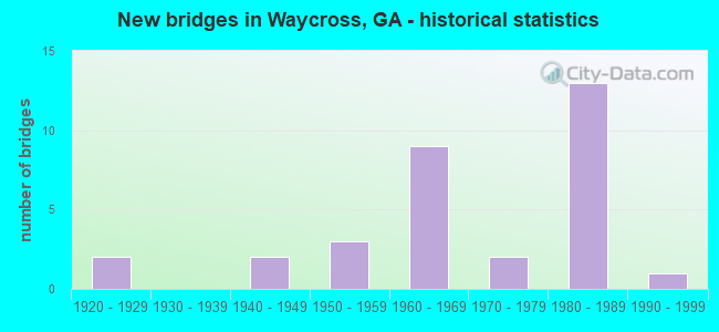
- New bridges - historical statistics
- 21920-1929
- 21940-1949
- 31950-1959
- 91960-1969
- 21970-1979
- 131980-1989
- 11990-1999

- Reconstructed bridges - Historical Statistics
- 11950-1959
- 01960-1969
- 11970-1979
- 01980-1989
- 31990-1999


- Bridge Condition - Deck
- 71.4%Good
- 14.3%Satisfactory
- 14.3%Fair

- Bridge Condition - Superstructure
- 14.3%Very good
- 64.3%Good
- 14.3%Satisfactory
- 7.1%Fair

- Bridge Condition - Substructure
- 78.6%Good
- 14.3%Satisfactory
- 7.1%Fair

- Bridge Condition - Channel
- 66.7%Very good
- 20.8%Good
- 4.2%Satisfactory
- 8.3%Fair

- Bridge Condition - Culverts
- 88.9%Good
- 5.6%Satisfactory
- 5.6%Fair
Find on map >> Show street view
Structure Number: 2990011, Location: CITY LIMITS OF WAYCROSS (Lat: 31.226258, Lng: -82.337978), Route carried "on" structure: US 84, Year Built: 1964, Status: Open, Structure Length: 0.67m (2.20ft), Average Daily Traffic: 12,920 (year 2012), Truck Traffic: 1%, Average Future Daily Traffic: 19,380 (year 2032), Design Load: HS 20+Mod, Features Intersected: SATILLA RIVER TRIB.
Minimum Vertical Clearance: 30+ m (98+ ft), Kilometerpoint: 32.187, Lanes on structure: 5, Base Highway Network: Yes, Owner: State Highway Agency, Approaching Roadway Width: 19.8m (65.0ft), Skew: 2 degrees, Material/Design: Concrete, Design/Construction: Culvert, Number Of Spans In Main Unit: 2, Length of Maximum Span: 3.4m (11.2ft), Curb or Sidewalk Widths: Left: 1.5m (4.9ft), Right: 0.0m
Condition: Channel: Very good, Culverts: Satisfactory, Operating Rating: 59.8 metric tons, Method Used To Determine Operating Rating: Load Factor (LF), Inventory Rating: 36.2 metric tons, Method Used To Determine Inventory Rating: Load Factor (LF), Structural Evaluation: Equal to present minimum criteria, Waterway Adequacy: Equal to present desirable criteria, Approach Roadway Alignment: Equal to present desirable criteria, Designated Inspection Frequency: Every 24 months, Inspection Date: October 2021, Bridge Improvement Cost: $156,000, Roadway Improvement Cost: $16,000, Total Project Cost: $234,000
Find on map >> Show street view
Structure Number: 2990013, Location: 2.5 MI E OF WAYCROSS (Lat: 31.238569, Lng: -82.322850), Route carried "on" structure: US 84, Year Built: 1923, Year Reconstructed: 1982, Status: Posted for load, Structure Length: 23.26m (76.31ft), Average Daily Traffic: 21,290 (year 2012), Truck Traffic: 8%, Average Future Daily Traffic: 31,935 (year 2032), Design Load: H 15, Features Intersected: SATILLA RIVER
Minimum Vertical Clearance: 30+ m (98+ ft), Kilometerpoint: 33.796, Lanes on structure: 4, Base Highway Network: Yes, Owner: State Highway Agency, Approaching Roadway Width: 22.3m (73.2ft), Material/Design: Concrete continuous, Design/Construction: Tee Beam, Number Of Spans In Main Unit: 25, Length of Maximum Span: 22.9m (75.1ft), Curb-To-Curb Width: 23.2m (76.1ft), Out-to-Out Width: 24.3m (79.7ft)
Condition: Deck: Satisfactory, Superstructure: Satisfactory, Substructure: Satisfactory, Channel: Good, Operating Rating: 29.0 metric tons, Method Used To Determine Operating Rating: Load Factor (LF), Inventory Rating: 17.2 metric tons, Method Used To Determine Inventory Rating: Load Factor (LF), Structural Evaluation: Meets minimum limits, Deck Geometry: Superior to present desirable criteria, Waterway Adequacy: Equal to present desirable criteria, Approach Roadway Alignment: Equal to present desirable criteria, Bridge Posting: Required (Relationship of Operating Rating to Maximum Legal Load: 10.0 - 19.9% below), Designated Inspection Frequency: Every 24 months, Underwater Inspection Frequency: Every 60 months, Inspection Date: October 2021, Underwater Inspection Date: March 2019, Deck Structure Type: Concrete Cast-file-Place, Wearing Surface/Protective System: Wearing Surface: Bituminous
Find on map >> Show street view
Structure Number: 2990018, Location: CITY LIMITS OF WAYCROSS (Lat: 31.226869, Lng: -82.398969), Route carried "on" structure: County highway 591, Year Built: 1924, Year Reconstructed: 1959, Status: Open, Structure Length: 4.72m (15.49ft), Average Daily Traffic: 4,650 (year 2012), Truck Traffic: 7%, Average Future Daily Traffic: 6,975 (year 2032), Design Load: H 15, Features Intersected: KETTLE CREEK, Facility Carried by Structure: ALBANY AVENUE
Minimum Vertical Clearance: 30+ m (98+ ft), Kilometerpoint: 8.047, Lanes on structure: 2, Base Highway Network: Yes, Owner: County Highway Agency, Approaching Roadway Width: 7.3m (24.0ft), Material/Design: Concrete, Design/Construction: Tee Beam, Number Of Spans In Main Unit: 6, Length of Maximum Span: 10.7m (35.1ft), Curb or Sidewalk Widths: Left: 0.6m (2.0ft), Right: 0.6m (2.0ft), Curb-To-Curb Width: 8.5m (27.9ft), Out-to-Out Width: 10.4m (34.1ft)
Condition: Deck: Fair, Superstructure: Fair, Substructure: Fair, Channel: Very good, Operating Rating: 39.9 metric tons, Method Used To Determine Operating Rating: Load Factor (LF), Inventory Rating: 23.5 metric tons, Method Used To Determine Inventory Rating: Load Factor (LF), Structural Evaluation: Somewhat better than minimum adequacy, Deck Geometry: Meets minimum limits, Waterway Adequacy: Equal to present desirable criteria, Approach Roadway Alignment: Equal to present desirable criteria, Designated Inspection Frequency: Every 24 months, Inspection Date: October 2021, Bridge Improvement Cost: $606,000, Roadway Improvement Cost: $61,000, Total Project Cost: $908,000, Deck Structure Type: Concrete Cast-file-Place, Wearing Surface/Protective System: Wearing Surface: Bituminous
Find on map >> Show street view
Structure Number: 299002, Location: 5 MI W OF WAYCROSS (Lat: 31.203958, Lng: -82.482369), Route carried "on" structure: State highway 122, Year Built: 1948, Status: Open, Structure Length: 1.49m (4.89ft), Average Daily Traffic: 970 (year 2012), Truck Traffic: 1%, Average Future Daily Traffic: 1,455 (year 2032), Design Load: H 15, Features Intersected: MUSKET BAY
Minimum Vertical Clearance: 30+ m (98+ ft), Kilometerpoint: 17.703, Lanes on structure: 2, Base Highway Network: Yes, Owner: State Highway Agency, Approaching Roadway Width: 7.0m (23.0ft), Skew: 4 degrees, Material/Design: Concrete, Design/Construction: Culvert, Number Of Spans In Main Unit: 6, Length of Maximum Span: 2.1m (6.9ft)
Condition: Channel: Very good, Culverts: Good, Operating Rating: 48.9 metric tons, Method Used To Determine Operating Rating: Load Factor (LF), Inventory Rating: 29.0 metric tons, Method Used To Determine Inventory Rating: Load Factor (LF), Structural Evaluation: Better than present minimum criteria, Waterway Adequacy: Equal to present desirable criteria, Approach Roadway Alignment: Equal to present desirable criteria, Designated Inspection Frequency: Every 24 months, Inspection Date: November 2021, Bridge Improvement Cost: $191,000, Roadway Improvement Cost: $19,000, Total Project Cost: $287,000
Find on map >> Show street view
Structure Number: 2990021, Location: IN CITY OF WAYCROSS (Lat: 31.214258, Lng: -82.404919), Route carried "on" structure: County highway 1221, Year Built: 1948, Status: Open, Structure Length: 1.77m (5.81ft), Average Daily Traffic: 3,480 (year 2012), Truck Traffic: 1%, Average Future Daily Traffic: 5,220 (year 2032), Design Load: H 15, Features Intersected: KETTLE CREEK, Facility Carried by Structure: CARSWELL ROAD
Minimum Vertical Clearance: 30+ m (98+ ft), Kilometerpoint: 25.750, Lanes on structure: 2, Base Highway Network: Yes, Owner: County Highway Agency, Approaching Roadway Width: 7.0m (23.0ft), Material/Design: Concrete, Design/Construction: Culvert, Number Of Spans In Main Unit: 5, Length of Maximum Span: 3.0m (9.8ft)
Condition: Channel: Very good, Culverts: Good, Operating Rating: 41.7 metric tons, Method Used To Determine Operating Rating: Field evaluation and documented engineering judgment, Inventory Rating: 24.4 metric tons, Method Used To Determine Inventory Rating: Field evaluation and documented engineering judgment, Structural Evaluation: Equal to present minimum criteria, Waterway Adequacy: Equal to present desirable criteria, Approach Roadway Alignment: Equal to present desirable criteria, Designated Inspection Frequency: Every 24 months, Inspection Date: October 2021, Bridge Improvement Cost: $227,000, Roadway Improvement Cost: $23,000, Total Project Cost: $340,000
Find on map >> Show street view
Structure Number: 299003, Location: CITY OF WAYCROSS (Lat: 31.207778, Lng: -82.361058), Route carried "on" structure: US 82, Year Built: 1981, Status: Open, Structure Length: 7.99m (26.21ft), Average Daily Traffic: 16,250 (year 2012), Truck Traffic: 1%, Average Future Daily Traffic: 24,375 (year 2032), Design Load: HS 20+Mod, Features Intersected: CSX RR- SR 38 PLANT AVE
Minimum Vertical Clearance: 30+ m (98+ ft), Kilometerpoint: 35.406, Lanes on structure: 4, Lanes under structure: 3, Base Highway Network: Yes, Owner: State Highway Agency, Approaching Roadway Width: 15.8m (51.8ft), Material/Design: Steel, Design/Construction: Stringer/Multi-beam, Number Of Spans In Main Unit: 2, Length of Maximum Span: 42.1m (138.1ft), Curb-To-Curb Width: 15.8m (51.8ft), Out-to-Out Width: 16.9m (55.4ft)
Condition: Deck: Good, Superstructure: Very good, Substructure: Good, Operating Rating: 82.5 metric tons, Method Used To Determine Operating Rating: Load Factor (LF), Inventory Rating: 48.9 metric tons, Method Used To Determine Inventory Rating: Load Factor (LF), Structural Evaluation: Better than present minimum criteria, Deck Geometry: Meets minimum limits, Underclear: Meets minimum limits, Approach Roadway Alignment: Equal to present desirable criteria, Designated Inspection Frequency: Every 24 months, Inspection Date: October 2021, Bridge Improvement Cost: $1,582,000, Roadway Improvement Cost: $158,000, Total Project Cost: $2,373,000, Deck Structure Type: Concrete Cast-file-Place
Find on map >> Show street view
Structure Number: 2990031, Location: CITY OF WAYCROSS (Lat: 31.206739, Lng: -82.359600), Route carried "on" structure: US 82, Year Built: 1981, Status: Open, Structure Length: 3.08m (10.10ft), Average Daily Traffic: 16,250 (year 2012), Truck Traffic: 1%, Average Future Daily Traffic: 24,375 (year 2032), Design Load: HS 20+Mod, Features Intersected: M-5201 HAINES AVENUE
Minimum Vertical Clearance: 30+ m (98+ ft), Kilometerpoint: 35.406, Lanes on structure: 4, Lanes under structure: 4, Base Highway Network: Yes, Owner: State Highway Agency, Approaching Roadway Width: 16.5m (54.1ft), Skew: 1 degrees, Material/Design: Steel, Design/Construction: Stringer/Multi-beam, Number Of Spans In Main Unit: 1, Length of Maximum Span: 30.8m (101.0ft), Curb-To-Curb Width: 15.8m (51.8ft), Out-to-Out Width: 16.9m (55.4ft)
Condition: Deck: Good, Superstructure: Good, Substructure: Good, Operating Rating: 72.5 metric tons, Method Used To Determine Operating Rating: Load Factor (LF), Inventory Rating: 43.5 metric tons, Method Used To Determine Inventory Rating: Load Factor (LF), Structural Evaluation: Better than present minimum criteria, Deck Geometry: Meets minimum limits, Underclear: Equal to present minimum criteria, Approach Roadway Alignment: Equal to present desirable criteria, Designated Inspection Frequency: Every 24 months, Inspection Date: October 2021, Bridge Improvement Cost: $610,000, Roadway Improvement Cost: $61,000, Total Project Cost: $915,000, Deck Structure Type: Concrete Cast-file-Place
Find on map >> Show street view
Structure Number: 299005, Location: 13 MI SW OF WAYCROSS (Lat: 31.041297, Lng: -82.412228), Route carried "on" structure: County highway 1709, Year Built: 1965, Status: Open, Structure Length: 2.01m (6.59ft), Average Daily Traffic: 70 (year 2012), Truck Traffic: 1%, Average Future Daily Traffic: 105 (year 2032), Design Load: H 15, Features Intersected: ALLIGATOR CREEK, Facility Carried by Structure: SWAMP ROAD
Minimum Vertical Clearance: 30+ m (98+ ft), Kilometerpoint: 49.890, Lanes on structure: 2, Base Highway Network: Yes, Owner: County Highway Agency, Approaching Roadway Width: 6.4m (21.0ft), Material/Design: Concrete, Design/Construction: Culvert, Number Of Spans In Main Unit: 6, Length of Maximum Span: 3.0m (9.8ft)
Condition: Channel: Fair, Culverts: Good, Operating Rating: 30.8 metric tons, Method Used To Determine Operating Rating: Field evaluation and documented engineering judgment, Inventory Rating: 24.4 metric tons, Method Used To Determine Inventory Rating: Field evaluation and documented engineering judgment, Structural Evaluation: Equal to present minimum criteria, Waterway Adequacy: Equal to present desirable criteria, Approach Roadway Alignment: Equal to present desirable criteria, Designated Inspection Frequency: Every 24 months, Inspection Date: December 2021, Bridge Improvement Cost: $258,000, Roadway Improvement Cost: $26,000, Total Project Cost: $387,000
Find on map >> Show street view
Structure Number: 2990059, Location: IN CITY LIMITS WAYCROSS (Lat: 31.197419, Lng: -82.358069), Route carried "on" structure: City street 5201, Year Built: 1968, Status: Open, Structure Length: 1.22m (4.00ft), Average Daily Traffic: 6,250 (year 2012), Truck Traffic: 1%, Average Future Daily Traffic: 9,375 (year 2032), Design Load: H 15, Features Intersected: SATILLA RIVER TRIB, Facility Carried by Structure: BRUNEL STREET
Minimum Vertical Clearance: 30+ m (98+ ft), Kilometerpoint: 0.000, Lanes on structure: 4, Base Highway Network: Yes, Owner: County Highway Agency, Approaching Roadway Width: 14.6m (47.9ft), Skew: 4 degrees, Material/Design: Concrete, Design/Construction: Culvert, Number Of Spans In Main Unit: 3, Length of Maximum Span: 4.0m (13.1ft)
Condition: Channel: Good, Culverts: Good, Operating Rating: 41.7 metric tons, Method Used To Determine Operating Rating: Field evaluation and documented engineering judgment, Inventory Rating: 24.4 metric tons, Method Used To Determine Inventory Rating: Field evaluation and documented engineering judgment, Structural Evaluation: Equal to present minimum criteria, Waterway Adequacy: Equal to present desirable criteria, Approach Roadway Alignment: Equal to present desirable criteria, Designated Inspection Frequency: Every 24 months, Inspection Date: October 2021, Bridge Improvement Cost: $242,000, Roadway Improvement Cost: $24,000, Total Project Cost: $362,000
Find on map >> Show street view
Structure Number: 299006, Location: IN CITY LIMITS WAYCROSS (Lat: 31.203050, Lng: -82.359719), Route carried "on" structure: City street 5201, Year Built: 1969, Status: Open, Structure Length: 8.02m (26.31ft), Average Daily Traffic: 5,340 (year 2012), Truck Traffic: 1%, Average Future Daily Traffic: 8,010 (year 2032), Design Load: HS 20+Mod, Features Intersected: CSX RAILROAD, Facility Carried by Structure: HAINES AVENUE
Minimum Vertical Clearance: 30+ m (98+ ft), Kilometerpoint: 1.609, Lanes on structure: 4, Base Highway Network: Yes, Owner: City or Municipal Highway Agency, Approaching Roadway Width: 14.6m (47.9ft), Skew: 4 degrees, Material/Design: Steel, Design/Construction: Stringer/Multi-beam, Number Of Spans In Main Unit: 5, Length of Maximum Span: 27.1m (88.9ft), Curb or Sidewalk Widths: Left: 1.4m (4.6ft), Right: 1.4m (4.6ft), Curb-To-Curb Width: 14.6m (47.9ft), Out-to-Out Width: 18.6m (61.0ft)
Condition: Deck: Fair, Superstructure: Satisfactory, Substructure: Good, Operating Rating: 48.9 metric tons, Method Used To Determine Operating Rating: Load Factor (LF), Inventory Rating: 29.0 metric tons, Method Used To Determine Inventory Rating: Load Factor (LF), Structural Evaluation: Equal to present minimum criteria, Deck Geometry: High priority of replacement, Underclear: Equal to present minimum criteria, Approach Roadway Alignment: Equal to present desirable criteria, Designated Inspection Frequency: Every 24 months, Inspection Date: October 2021, Bridge Improvement Cost: $1,588,000, Roadway Improvement Cost: $159,000, Total Project Cost: $2,382,000, Deck Structure Type: Concrete Cast-file-Place
Find on map >> Show street view
Structure Number: 2990061, Location: 1.2 MI NORTH OF WAYCROSS (Lat: 31.229478, Lng: -82.344847), Route carried "on" structure: City street 5206, Year Built: 1972, Status: Open, Structure Length: 0.70m (2.30ft), Average Daily Traffic: 4,710 (year 2012), Truck Traffic: 1%, Average Future Daily Traffic: 7,065 (year 2032), Design Load: HS 20+Mod, Features Intersected: SATILLA RIVER TRIB, Facility Carried by Structure: TEBEAU STREET
Minimum Vertical Clearance: 30+ m (98+ ft), Kilometerpoint: 3.219, Lanes on structure: 4, Base Highway Network: Yes, Owner: City or Municipal Highway Agency, Approaching Roadway Width: 20.7m (67.9ft), Material/Design: Concrete, Design/Construction: Culvert, Number Of Spans In Main Unit: 4, Length of Maximum Span: 2.1m (6.9ft), Curb or Sidewalk Widths: Left: 1.7m (5.6ft), Right: 1.7m (5.6ft)
Condition: Channel: Satisfactory, Culverts: Good, Operating Rating: 55.3 metric tons, Method Used To Determine Operating Rating: Field evaluation and documented engineering judgment, Inventory Rating: 32.6 metric tons, Method Used To Determine Inventory Rating: Field evaluation and documented engineering judgment, Structural Evaluation: Better than present minimum criteria, Waterway Adequacy: Equal to present desirable criteria, Approach Roadway Alignment: Equal to present desirable criteria, Designated Inspection Frequency: Every 24 months, Inspection Date: October 2021, Bridge Improvement Cost: $139,000, Roadway Improvement Cost: $14,000, Total Project Cost: $208,000
Find on map >> Show street view
Structure Number: 2990062, Location: 1 MI NW OF WAYCROSS (Lat: 31.235819, Lng: -82.388139), Route carried "on" structure: City street 5211, Year Built: 1960, Year Reconstructed: 2004, Status: Open, Structure Length: 3.05m (10.01ft), Average Daily Traffic: 1,830 (year 2012), Truck Traffic: 1%, Average Future Daily Traffic: 2,745 (year 2032), Design Load: H 15, Features Intersected: KETTLE CREEK, Facility Carried by Structure: CHEROKEE STREET
Minimum Vertical Clearance: 30+ m (98+ ft), Kilometerpoint: 3.219, Lanes on structure: 2, Base Highway Network: Yes, Owner: County Highway Agency, Approaching Roadway Width: 6.7m (22.0ft), Material/Design: Prestressed concrete, Design/Construction: Channel Beam, Number Of Spans In Main Unit: 5, Length of Maximum Span: 6.1m (20.0ft), Curb-To-Curb Width: 7.1m (23.3ft), Out-to-Out Width: 7.7m (25.3ft)
Condition: Deck: Satisfactory, Superstructure: Good, Substructure: Good, Channel: Very good, Operating Rating: 45.3 metric tons, Method Used To Determine Operating Rating: Load Factor (LF), Inventory Rating: 27.2 metric tons, Method Used To Determine Inventory Rating: Load Factor (LF), Structural Evaluation: Equal to present minimum criteria, Deck Geometry: High priority of corrective action, Waterway Adequacy: Equal to present desirable criteria, Approach Roadway Alignment: Equal to present desirable criteria, Designated Inspection Frequency: Every 24 months, Underwater Inspection Frequency: Every 60 months, Inspection Date: October 2021, Underwater Inspection Date: March 2019, Bridge Improvement Cost: $391,000, Roadway Improvement Cost: $39,000, Total Project Cost: $586,000, Deck Structure Type: Concrete Precast Panels
Find on map >> Show street view
Structure Number: 2990063, Location: IN CITY LIMITS WAYCROSS (Lat: 31.227819, Lng: -82.330397), Route carried "on" structure: City street 5211, Year Built: 1960, Status: Open, Structure Length: 1.43m (4.69ft), Average Daily Traffic: 3,480 (year 2012), Truck Traffic: 1%, Average Future Daily Traffic: 5,220 (year 2032), Design Load: H 15, Features Intersected: SATILLA RIVER TRIB, Facility Carried by Structure: MORNINGSIDE DRIVE
Minimum Vertical Clearance: 30+ m (98+ ft), Kilometerpoint: 9.656, Lanes on structure: 2, Base Highway Network: Yes, Owner: County Highway Agency, Approaching Roadway Width: 6.1m (20.0ft), Material/Design: Concrete, Design/Construction: Culvert, Number Of Spans In Main Unit: 4, Length of Maximum Span: 3.0m (9.8ft)
Condition: Channel: Good, Culverts: Fair, Operating Rating: 41.7 metric tons, Method Used To Determine Operating Rating: Field evaluation and documented engineering judgment, Inventory Rating: 24.4 metric tons, Method Used To Determine Inventory Rating: Field evaluation and documented engineering judgment, Structural Evaluation: Somewhat better than minimum adequacy, Waterway Adequacy: Equal to present desirable criteria, Approach Roadway Alignment: Equal to present desirable criteria, Designated Inspection Frequency: Every 24 months, Inspection Date: October 2021, Bridge Improvement Cost: $184,000, Roadway Improvement Cost: $18,000, Total Project Cost: $275,000
Find on map >> Show street view
Structure Number: 299007, Location: 4 MI W OF WAYCROSS (Lat: 31.235011, Lng: -82.426994), Route carried "on" structure: US 82, Year Built: 1984, Status: Open, Structure Length: 5.06m (16.60ft), Average Daily Traffic: 6,840 (year 2007), Truck Traffic: 1%, Average Future Daily Traffic: 10,260 (year 2030), Design Load: HS 20+Mod, Features Intersected: CR 591
Minimum Vertical Clearance: 30+ m (98+ ft), Kilometerpoint: 27.359, Lanes on structure: 2, Lanes under structure: 2, Base Highway Network: Yes, Owner: State Highway Agency, Approaching Roadway Width: 9.1m (29.9ft), Skew: 11 degrees, Material/Design: Prestressed concrete, Design/Construction: Stringer/Multi-beam, Number Of Spans In Main Unit: 3, Length of Maximum Span: 25.0m (82.0ft), Curb-To-Curb Width: 12.8m (42.0ft), Out-to-Out Width: 13.8m (45.3ft)
Condition: Deck: Good, Superstructure: Good, Substructure: Good, Operating Rating: 62.5 metric tons, Method Used To Determine Operating Rating: Load Factor (LF), Inventory Rating: 25.4 metric tons, Method Used To Determine Inventory Rating: Load Factor (LF), Structural Evaluation: Equal to present minimum criteria, Deck Geometry: Equal to present desirable criteria, Underclear: Better than present minimum criteria, Approach Roadway Alignment: Equal to present desirable criteria, Designated Inspection Frequency: Every 24 months, Inspection Date: November 2021, Bridge Improvement Cost: $649,000, Roadway Improvement Cost: $65,000, Total Project Cost: $973,000, Deck Structure Type: Concrete Cast-file-Place
Find on map >> Show street view
Structure Number: 2990071, Location: 4 MI W OF WAYCROSS (Lat: 31.234939, Lng: -82.426783), Route carried "on" structure: US 82, Year Built: 1984, Status: Open, Structure Length: 5.06m (16.60ft), Average Daily Traffic: 6,840 (year 2007), Truck Traffic: 1%, Average Future Daily Traffic: 10,260 (year 2030), Design Load: HS 20+Mod, Features Intersected: CR 591
Minimum Vertical Clearance: 30+ m (98+ ft), Kilometerpoint: 27.359, Lanes on structure: 2, Lanes under structure: 2, Base Highway Network: Yes, Owner: State Highway Agency, Approaching Roadway Width: 9.8m (32.2ft), Skew: 11 degrees, Material/Design: Prestressed concrete, Design/Construction: Stringer/Multi-beam, Number Of Spans In Main Unit: 3, Length of Maximum Span: 25.0m (82.0ft), Curb-To-Curb Width: 12.8m (42.0ft), Out-to-Out Width: 13.8m (45.3ft)
Condition: Deck: Good, Superstructure: Good, Substructure: Good, Operating Rating: 62.5 metric tons, Method Used To Determine Operating Rating: Load Factor (LF), Inventory Rating: 25.4 metric tons, Method Used To Determine Inventory Rating: Load Factor (LF), Structural Evaluation: Equal to present minimum criteria, Deck Geometry: Equal to present desirable criteria, Underclear: Better than present minimum criteria, Approach Roadway Alignment: Equal to present desirable criteria, Designated Inspection Frequency: Every 24 months, Inspection Date: November 2021, Bridge Improvement Cost: $649,000, Roadway Improvement Cost: $65,000, Total Project Cost: $973,000, Deck Structure Type: Concrete Cast-file-Place
Find on map >> Show street view
Structure Number: 2990072, Location: 4 MI W OF WAYCROSS (Lat: 31.234156, Lng: -82.427056), Route carried "on" structure: US 82, Year Built: 1984, Status: Open, Structure Length: 5.39m (17.68ft), Average Daily Traffic: 8,730 (year 2012), Truck Traffic: 26%, Average Future Daily Traffic: 13,095 (year 2032), Design Load: HS 20+Mod, Features Intersected: CSX RAILROAD 908585W
Minimum Vertical Clearance: 30+ m (98+ ft), Kilometerpoint: 27.359, Lanes on structure: 2, Base Highway Network: Yes, Owner: State Highway Agency, Approaching Roadway Width: 9.4m (30.8ft), Skew: 11 degrees, Material/Design: Prestressed concrete, Design/Construction: Stringer/Multi-beam, Number Of Spans In Main Unit: 3, Length of Maximum Span: 20.4m (66.9ft), Curb-To-Curb Width: 12.8m (42.0ft), Out-to-Out Width: 13.8m (45.3ft)
Condition: Deck: Good, Superstructure: Good, Substructure: Good, Operating Rating: 64.4 metric tons, Method Used To Determine Operating Rating: Load Factor (LF), Inventory Rating: 29.0 metric tons, Method Used To Determine Inventory Rating: Load Factor (LF), Structural Evaluation: Better than present minimum criteria, Deck Geometry: Equal to present desirable criteria, Underclear: Somewhat better than minimum adequacy, Approach Roadway Alignment: Equal to present desirable criteria, Designated Inspection Frequency: Every 24 months, Inspection Date: November 2021, Bridge Improvement Cost: $692,000, Roadway Improvement Cost: $69,000, Total Project Cost: $1,037,000, Deck Structure Type: Concrete Cast-file-Place
Find on map >> Show street view
Structure Number: 2990073, Location: 4 MI W OF WAYCROSS (Lat: 31.234069, Lng: -82.426839), Route carried "on" structure: US 82, Year Built: 1984, Status: Open, Structure Length: 5.39m (17.68ft), Average Daily Traffic: 8,730 (year 2012), Truck Traffic: 26%, Average Future Daily Traffic: 13,095 (year 2032), Design Load: HS 20+Mod, Features Intersected: CSX RAILROAD 908586W
Minimum Vertical Clearance: 30+ m (98+ ft), Kilometerpoint: 27.359, Lanes on structure: 2, Base Highway Network: Yes, Owner: State Highway Agency, Approaching Roadway Width: 8.8m (28.9ft), Skew: 11 degrees, Material/Design: Prestressed concrete, Design/Construction: Stringer/Multi-beam, Number Of Spans In Main Unit: 3, Length of Maximum Span: 20.4m (66.9ft), Curb-To-Curb Width: 12.8m (42.0ft), Out-to-Out Width: 13.8m (45.3ft)
Condition: Deck: Good, Superstructure: Good, Substructure: Good, Operating Rating: 64.4 metric tons, Method Used To Determine Operating Rating: Load Factor (LF), Inventory Rating: 29.0 metric tons, Method Used To Determine Inventory Rating: Load Factor (LF), Structural Evaluation: Better than present minimum criteria, Deck Geometry: Equal to present desirable criteria, Underclear: Somewhat better than minimum adequacy, Approach Roadway Alignment: Equal to present desirable criteria, Designated Inspection Frequency: Every 24 months, Inspection Date: November 2021, Bridge Improvement Cost: $692,000, Roadway Improvement Cost: $69,000, Total Project Cost: $1,037,000, Deck Structure Type: Concrete Cast-file-Place
Find on map >> Show street view
Structure Number: 2990074, Location: 2 MI W OF WAYCROSS (Lat: 31.209319, Lng: -82.406628), Route carried "on" structure: US 82, Year Built: 1984, Status: Open, Structure Length: 0.98m (3.22ft), Average Daily Traffic: 9,270 (year 2012), Truck Traffic: 1%, Average Future Daily Traffic: 13,905 (year 2032), Design Load: HS 20+Mod, Features Intersected: KETTLE CREEK
Minimum Vertical Clearance: 30+ m (98+ ft), Kilometerpoint: 32.187, Lanes on structure: 4, Base Highway Network: Yes, Owner: State Highway Agency, Approaching Roadway Width: 18.6m (61.0ft), Skew: 12 degrees, Material/Design: Concrete, Design/Construction: Culvert, Number Of Spans In Main Unit: 3, Length of Maximum Span: 3.0m (9.8ft)
Condition: Channel: Very good, Culverts: Good, Operating Rating: 59.8 metric tons, Method Used To Determine Operating Rating: Load Factor (LF), Inventory Rating: 36.2 metric tons, Method Used To Determine Inventory Rating: Load Factor (LF), Structural Evaluation: Better than present minimum criteria, Waterway Adequacy: Equal to present desirable criteria, Approach Roadway Alignment: Equal to present desirable criteria, Designated Inspection Frequency: Every 24 months, Inspection Date: October 2021, Bridge Improvement Cost: $193,000, Roadway Improvement Cost: $19,000, Total Project Cost: $290,000
Find on map >> Show street view
Structure Number: 2990075, Location: CITY OF WAYCROSS (Lat: 31.208869, Lng: -82.367758), Route carried "on" structure: US 82, Year Built: 1984, Status: Open, Structure Length: 4.75m (15.58ft), Average Daily Traffic: 19,290 (year 2012), Truck Traffic: 16%, Average Future Daily Traffic: 28,935 (year 2032), Design Load: HS 20+Mod, Features Intersected: CSX RAILROAD
Minimum Vertical Clearance: 30+ m (98+ ft), Kilometerpoint: 35.406, Lanes on structure: 5, Base Highway Network: Yes, Owner: State Highway Agency, Approaching Roadway Width: 20.4m (66.9ft), Skew: 1 degrees, Material/Design: Prestressed concrete, Design/Construction: Stringer/Multi-beam, Number Of Spans In Main Unit: 3, Length of Maximum Span: 21.0m (68.9ft), Curb or Sidewalk Widths: Left: 1.8m (5.9ft), Right: 1.8m (5.9ft), Curb-To-Curb Width: 20.1m (65.9ft), Out-to-Out Width: 24.5m (80.4ft)
Condition: Deck: Good, Superstructure: Very good, Substructure: Good, Operating Rating: 55.3 metric tons, Method Used To Determine Operating Rating: Load Factor (LF), Inventory Rating: 28.1 metric tons, Method Used To Determine Inventory Rating: Load Factor (LF), Structural Evaluation: Better than present minimum criteria, Deck Geometry: Somewhat better than minimum adequacy, Underclear: Somewhat better than minimum adequacy, Approach Roadway Alignment: Equal to present desirable criteria, Designated Inspection Frequency: Every 24 months, Inspection Date: October 2021, Bridge Improvement Cost: $1,108,000, Roadway Improvement Cost: $111,000, Total Project Cost: $1,662,000, Deck Structure Type: Concrete Cast-file-Place
Find on map >> Show street view
Structure Number: 2990076, Location: 4.7 MI E OF WAYCROSS (Lat: 31.190478, Lng: -82.278628), Route carried "on" structure: US 82, Year Built: 1985, Status: Open, Structure Length: 0.82m (2.69ft), Average Daily Traffic: 8,270 (year 2012), Truck Traffic: 12%, Average Future Daily Traffic: 12,405 (year 2032), Design Load: HS 20+Mod, Features Intersected: SATILLA RIVER TRIB
Minimum Vertical Clearance: 30+ m (98+ ft), Kilometerpoint: 43.452, Lanes on structure: 5, Base Highway Network: Yes, Owner: State Highway Agency, Approaching Roadway Width: 21.3m (69.9ft), Material/Design: Concrete, Design/Construction: Culvert, Number Of Spans In Main Unit: 5, Length of Maximum Span: 1.2m (3.9ft)
Condition: Channel: Very good, Culverts: Good, Operating Rating: 55.3 metric tons, Method Used To Determine Operating Rating: Field evaluation and documented engineering judgment, Inventory Rating: 32.6 metric tons, Method Used To Determine Inventory Rating: Field evaluation and documented engineering judgment, Structural Evaluation: Better than present minimum criteria, Waterway Adequacy: Equal to present desirable criteria, Approach Roadway Alignment: Equal to present desirable criteria, Designated Inspection Frequency: Every 24 months, Inspection Date: November 2021, Bridge Improvement Cost: $192,000, Roadway Improvement Cost: $19,000, Total Project Cost: $288,000
Find on map >> Show street view
Structure Number: 2995042, Location: 5 MI S OF WAYCROSS (Lat: 31.169939, Lng: -82.363989), Route carried "on" structure: County highway 490, Year Built: 1980, Status: Open, Structure Length: 0.82m (2.69ft), Average Daily Traffic: 490 (year 2012), Truck Traffic: 1%, Average Future Daily Traffic: 735 (year 2032), Design Load: HS 20+Mod, Features Intersected: BOGGY BAY, Facility Carried by Structure: EIGHT MILE POST RD
Minimum Vertical Clearance: 30+ m (98+ ft), Kilometerpoint: 0.000, Lanes on structure: 2, Base Highway Network: Yes, Owner: County Highway Agency, Approaching Roadway Width: 6.4m (21.0ft), Skew: 3 degrees, Material/Design: Concrete, Design/Construction: Culvert, Number Of Spans In Main Unit: 3, Length of Maximum Span: 2.4m (7.9ft)
Condition: Channel: Very good, Culverts: Good, Operating Rating: 55.3 metric tons, Method Used To Determine Operating Rating: Field evaluation and documented engineering judgment, Inventory Rating: 32.6 metric tons, Method Used To Determine Inventory Rating: Field evaluation and documented engineering judgment, Structural Evaluation: Better than present minimum criteria, Waterway Adequacy: Equal to present desirable criteria, Approach Roadway Alignment: Equal to present desirable criteria, Designated Inspection Frequency: Every 24 months, Inspection Date: December 2021, Bridge Improvement Cost: $105,000, Roadway Improvement Cost: $11,000, Total Project Cost: $158,000
Find on map >> Show street view
Structure Number: 2995047, Location: 3 MI SW OF WAYCROSS (Lat: 31.175439, Lng: -82.418308), Route carried "on" structure: County highway 91, Year Built: 1980, Status: Open, Structure Length: 0.79m (2.59ft), Average Daily Traffic: 130 (year 2012), Truck Traffic: 1%, Average Future Daily Traffic: 195 (year 2032), Design Load: HS 20+Mod, Features Intersected: KETTLE CREEK, Facility Carried by Structure: SMITH ROAD
Minimum Vertical Clearance: 30+ m (98+ ft), Kilometerpoint: 4.828, Lanes on structure: 2, Base Highway Network: Yes, Owner: County Highway Agency, Approaching Roadway Width: 6.7m (22.0ft), Material/Design: Concrete, Design/Construction: Culvert, Number Of Spans In Main Unit: 3, Length of Maximum Span: 2.4m (7.9ft)
Condition: Channel: Very good, Culverts: Good, Operating Rating: 55.3 metric tons, Method Used To Determine Operating Rating: Field evaluation and documented engineering judgment, Inventory Rating: 32.6 metric tons, Method Used To Determine Inventory Rating: Field evaluation and documented engineering judgment, Structural Evaluation: Better than present minimum criteria, Waterway Adequacy: Equal to present desirable criteria, Approach Roadway Alignment: Equal to present desirable criteria, Designated Inspection Frequency: Every 24 months, Inspection Date: December 2021, Bridge Improvement Cost: $102,000, Roadway Improvement Cost: $10,000, Total Project Cost: $152,000
Find on map >> Show street view
Structure Number: 2995074, Location: 1.5 MI W OF WAYCROSS (Lat: 31.194558, Lng: -82.407189), Route carried "on" structure: County highway 294, Year Built: 1965, Year Reconstructed: 2004, Status: Open, Structure Length: 1.83m (6.00ft), Average Daily Traffic: 750 (year 2012), Truck Traffic: 1%, Average Future Daily Traffic: 1,125 (year 2032), Design Load: H 15, Features Intersected: KETTLE CREEK, Facility Carried by Structure: WADLEY ROAD
Minimum Vertical Clearance: 30+ m (98+ ft), Kilometerpoint: 1.609, Lanes on structure: 2, Base Highway Network: Yes, Owner: County Highway Agency, Approaching Roadway Width: 6.4m (21.0ft), Material/Design: Prestressed concrete, Design/Construction: Channel Beam, Number Of Spans In Main Unit: 3, Length of Maximum Span: 6.1m (20.0ft), Curb-To-Curb Width: 7.1m (23.3ft), Out-to-Out Width: 7.7m (25.3ft)
Condition: Deck: Good, Superstructure: Good, Substructure: Good, Channel: Very good, Operating Rating: 46.2 metric tons, Method Used To Determine Operating Rating: Load Factor (LF), Inventory Rating: 27.2 metric tons, Method Used To Determine Inventory Rating: Load Factor (LF), Structural Evaluation: Equal to present minimum criteria, Deck Geometry: Meets minimum limits, Waterway Adequacy: Equal to present desirable criteria, Approach Roadway Alignment: Equal to present desirable criteria, Designated Inspection Frequency: Every 24 months, Inspection Date: November 2021, Bridge Improvement Cost: $234,000, Roadway Improvement Cost: $23,000, Total Project Cost: $352,000, Deck Structure Type: Concrete Precast Panels
Find on map >> Show street view
Structure Number: 2995075, Location: 1.5 MI W OF WAYCROSS (Lat: 31.227989, Lng: -82.399958), Route carried "on" structure: County highway 308, Year Built: 1989, Status: Open, Structure Length: 1.34m (4.40ft), Average Daily Traffic: 350 (year 2012), Truck Traffic: 1%, Average Future Daily Traffic: 525 (year 2032), Design Load: HS 20+Mod, Features Intersected: KETTLE CREEK TRIB., Facility Carried by Structure: RED KEEN STREET
Minimum Vertical Clearance: 30+ m (98+ ft), Kilometerpoint: 0.000, Lanes on structure: 2, Base Highway Network: Yes, Owner: County Highway Agency, Approaching Roadway Width: 6.1m (20.0ft), Material/Design: Concrete, Design/Construction: Culvert, Number Of Spans In Main Unit: 4, Length of Maximum Span: 3.0m (9.8ft)
Condition: Channel: Very good, Culverts: Good, Operating Rating: 55.3 metric tons, Method Used To Determine Operating Rating: Field evaluation and documented engineering judgment, Inventory Rating: 32.6 metric tons, Method Used To Determine Inventory Rating: Field evaluation and documented engineering judgment, Structural Evaluation: Better than present minimum criteria, Waterway Adequacy: Equal to present desirable criteria, Approach Roadway Alignment: Equal to present desirable criteria, Designated Inspection Frequency: Every 24 months, Inspection Date: October 2021, Bridge Improvement Cost: $172,000, Roadway Improvement Cost: $17,000, Total Project Cost: $258,000
Find on map >> Show street view
Structure Number: 2995076, Location: 2 MI W OF WAYCROSS (Lat: 31.228978, Lng: -82.403147), Route carried "on" structure: City street 5213, Year Built: 1960, Status: Open, Structure Length: 0.98m (3.22ft), Average Daily Traffic: 2,260 (year 2012), Truck Traffic: 1%, Average Future Daily Traffic: 3,390 (year 2032), Design Load: H 15, Features Intersected: KETTLE CREEK TRIB., Facility Carried by Structure: GORMAN STREET
Minimum Vertical Clearance: 30+ m (98+ ft), Kilometerpoint: 3.219, Lanes on structure: 2, Base Highway Network: Yes, Owner: City or Municipal Highway Agency, Approaching Roadway Width: 7.0m (23.0ft), Material/Design: Concrete, Design/Construction: Culvert, Number Of Spans In Main Unit: 3, Length of Maximum Span: 3.0m (9.8ft)
Condition: Channel: Good, Culverts: Good, Operating Rating: 41.7 metric tons, Method Used To Determine Operating Rating: Field evaluation and documented engineering judgment, Inventory Rating: 24.4 metric tons, Method Used To Determine Inventory Rating: Field evaluation and documented engineering judgment, Structural Evaluation: Equal to present minimum criteria, Waterway Adequacy: Equal to present desirable criteria, Approach Roadway Alignment: Equal to present desirable criteria, Designated Inspection Frequency: Every 24 months, Inspection Date: October 2021, Bridge Improvement Cost: $125,000, Roadway Improvement Cost: $13,000, Total Project Cost: $188,000
Find on map >> Show street view
Structure Number: 299508, Location: 3.1 MI NW OF BICKLEY (Lat: 31.443689, Lng: -82.575000), Route carried "on" structure: County highway 478, Year Built: 1955, Status: Open, Structure Length: 1.65m (5.41ft), Average Daily Traffic: 490 (year 2012), Truck Traffic: 1%, Average Future Daily Traffic: 735 (year 2032), Design Load: H 15, Features Intersected: BRUSHY CREEK, Facility Carried by Structure: LUCY MOORE ROAD
Minimum Vertical Clearance: 30+ m (98+ ft), Kilometerpoint: 4.828, Lanes on structure: 2, Base Highway Network: Yes, Owner: County Highway Agency, Approaching Roadway Width: 6.1m (20.0ft), Material/Design: Concrete, Design/Construction: Culvert, Number Of Spans In Main Unit: 6, Length of Maximum Span: 2.4m (7.9ft)
Condition: Channel: Good, Culverts: Good, Operating Rating: 41.7 metric tons, Method Used To Determine Operating Rating: Field evaluation and documented engineering judgment, Inventory Rating: 24.4 metric tons, Method Used To Determine Inventory Rating: Field evaluation and documented engineering judgment, Structural Evaluation: Equal to present minimum criteria, Waterway Adequacy: Equal to present desirable criteria, Approach Roadway Alignment: Equal to present desirable criteria, Designated Inspection Frequency: Every 24 months, Inspection Date: November 2021, Bridge Improvement Cost: $211,000, Roadway Improvement Cost: $21,000, Total Project Cost: $316,000
Find on map >> Show street view
Structure Number: 2995082, Location: CITY OF WAYCROSS (Lat: 31.225889, Lng: -82.340539), Route carried "on" structure: City street 608, Year Built: 1960, Status: Open, Structure Length: 1.37m (4.49ft), Average Daily Traffic: 360 (year 2012), Truck Traffic: 1%, Average Future Daily Traffic: 540 (year 2032), Design Load: H 15, Features Intersected: SATILLA RIVER TRIB, Facility Carried by Structure: RICARDO STREET
Minimum Vertical Clearance: 30+ m (98+ ft), Kilometerpoint: 0.000, Lanes on structure: 2, Base Highway Network: Yes, Owner: City or Municipal Highway Agency, Approaching Roadway Width: 6.4m (21.0ft), Material/Design: Concrete, Design/Construction: Channel Beam, Number Of Spans In Main Unit: 3, Length of Maximum Span: 4.6m (15.1ft), Curb or Sidewalk Widths: Left: 0.2m (0.7ft), Right: 0.2m (0.7ft), Curb-To-Curb Width: 7.3m (24.0ft), Out-to-Out Width: 7.7m (25.3ft)
Condition: Deck: Good, Superstructure: Good, Substructure: Satisfactory, Channel: Fair, Operating Rating: 47.1 metric tons, Method Used To Determine Operating Rating: Load Factor (LF), Inventory Rating: 28.1 metric tons, Method Used To Determine Inventory Rating: Load Factor (LF), Structural Evaluation: Equal to present minimum criteria, Deck Geometry: Somewhat better than minimum adequacy, Waterway Adequacy: Equal to present desirable criteria, Approach Roadway Alignment: Equal to present desirable criteria, Length Of Structure Improvement: 41.64m (136.61ft), Designated Inspection Frequency: Every 24 months, Inspection Date: October 2021, Bridge Improvement Cost: $176,000, Roadway Improvement Cost: $18,000, Total Project Cost: $264,000, Deck Structure Type: Concrete Precast Panels, Wearing Surface/Protective System: Wearing Surface: Bituminous
Find on map >> Show street view
Structure Number: 2995083, Location: CITY OF WAYCROSS (Lat: 31.216789, Lng: -82.348950), Route carried "on" structure: City street 611, Year Built: 1950, Status: Open, Structure Length: 0.64m (2.10ft), Average Daily Traffic: 590 (year 2012), Truck Traffic: 1%, Average Future Daily Traffic: 885 (year 2032), Design Load: H 15, Features Intersected: SATILLA RIVER TRIB, Facility Carried by Structure: SCREVEN AVENUE
Minimum Vertical Clearance: 30+ m (98+ ft), Kilometerpoint: 1.609, Lanes on structure: 2, Base Highway Network: Yes, Owner: City or Municipal Highway Agency, Approaching Roadway Width: 9.4m (30.8ft), Material/Design: Steel, Design/Construction: Culvert, Number Of Spans In Main Unit: 1, Length of Maximum Span: 6.4m (21.0ft), Curb or Sidewalk Widths: Left: 0.6m (2.0ft), Right: 0.9m (3.0ft)
Condition: Channel: Very good, Culverts: Good, Operating Rating: 41.7 metric tons, Method Used To Determine Operating Rating: Field evaluation and documented engineering judgment, Inventory Rating: 24.4 metric tons, Method Used To Determine Inventory Rating: Field evaluation and documented engineering judgment, Structural Evaluation: Equal to present minimum criteria, Waterway Adequacy: Equal to present desirable criteria, Approach Roadway Alignment: Equal to present desirable criteria, Designated Inspection Frequency: Every 24 months, Inspection Date: October 2021, Bridge Improvement Cost: $82,000, Roadway Improvement Cost: $8,000, Total Project Cost: $123,000
Find on map >> Show street view
Structure Number: 2995084, Location: CITY OF WAYCROSS (Lat: 31.226458, Lng: -82.333978), Route carried "on" structure: City street 619, Year Built: 1955, Year Reconstructed: 1998, Status: Posted for load, Structure Length: 1.37m (4.49ft), Average Daily Traffic: 830 (year 2012), Truck Traffic: 1%, Average Future Daily Traffic: 1,245 (year 2032), Design Load: H 15, Features Intersected: SATILLA RIVER TRIB, Facility Carried by Structure: CITY BOULEVARD
Minimum Vertical Clearance: 30+ m (98+ ft), Kilometerpoint: 0.000, Lanes on structure: 2, Base Highway Network: Yes, Owner: City or Municipal Highway Agency, Approaching Roadway Width: 9.4m (30.8ft), Material/Design: Concrete, Design/Construction: Slab, Number Of Spans In Main Unit: 3, Length of Maximum Span: 4.6m (15.1ft), Curb or Sidewalk Widths: Left: 0.2m (0.7ft), Right: 0.2m (0.7ft), Curb-To-Curb Width: 7.3m (24.0ft), Out-to-Out Width: 7.7m (25.3ft)
Condition: Deck: Good, Superstructure: Good, Substructure: Good, Channel: Very good, Operating Rating: 29.9 metric tons, Method Used To Determine Operating Rating: Load Factor (LF), Inventory Rating: 19.0 metric tons, Method Used To Determine Inventory Rating: Load Factor (LF), Structural Evaluation: Somewhat better than minimum adequacy, Deck Geometry: Meets minimum limits, Waterway Adequacy: Equal to present desirable criteria, Approach Roadway Alignment: Equal to present desirable criteria, Bridge Posting: Required (Relationship of Operating Rating to Maximum Legal Load: 10.0 - 19.9% below), Length Of Structure Improvement: 7.83m (25.69ft), Designated Inspection Frequency: Every 24 months, Inspection Date: October 2021, Bridge Improvement Cost: $176,000, Roadway Improvement Cost: $18,000, Total Project Cost: $264,000, Deck Structure Type: Concrete Precast Panels, Wearing Surface/Protective System: Wearing Surface: Bituminous
Find on map >> Show street view
Structure Number: 2995086, Location: CITY OF WAYCROSS (Lat: 31.222669, Lng: -82.345928), Route carried "on" structure: City street 609, Year Built: 1972, Status: Open, Structure Length: 1.04m (3.41ft), Average Daily Traffic: 1,960 (year 2012), Truck Traffic: 1%, Average Future Daily Traffic: 2,940 (year 2032), Design Load: HS 20+Mod, Features Intersected: SATILLA RIVER TRIB, Facility Carried by Structure: DARLING AVENUE
Minimum Vertical Clearance: 30+ m (98+ ft), Kilometerpoint: 0.000, Lanes on structure: 2, Base Highway Network: Yes, Owner: City or Municipal Highway Agency, Approaching Roadway Width: 13.4m (44.0ft), Skew: 5 degrees, Material/Design: Concrete, Design/Construction: Culvert, Number Of Spans In Main Unit: 2, Length of Maximum Span: 4.9m (16.1ft), Curb or Sidewalk Widths: Left: 1.5m (4.9ft), Right: 0.0m
Condition: Channel: Very good, Culverts: Good, Operating Rating: 55.3 metric tons, Method Used To Determine Operating Rating: Field evaluation and documented engineering judgment, Inventory Rating: 32.6 metric tons, Method Used To Determine Inventory Rating: Field evaluation and documented engineering judgment, Structural Evaluation: Better than present minimum criteria, Waterway Adequacy: Equal to present desirable criteria, Approach Roadway Alignment: Equal to present desirable criteria, Designated Inspection Frequency: Every 24 months, Inspection Date: October 2021, Bridge Improvement Cost: $133,000, Roadway Improvement Cost: $13,000, Total Project Cost: $199,000
Find on map >> Show street view
Structure Number: 2995088, Location: WAYCROSS-SOUTHSIDE C/L (Lat: 31.202639, Lng: -82.350147), Route carried "on" structure: City street 678, Year Built: 1984, Status: Open, Structure Length: 0.73m (2.40ft), Average Daily Traffic: 600 (year 2012), Truck Traffic: 1%, Average Future Daily Traffic: 900 (year 2032), Design Load: HS 20+Mod, Features Intersected: SATILLA RIVER TRIB, Facility Carried by Structure: MARION STREET
Minimum Vertical Clearance: 30+ m (98+ ft), Kilometerpoint: 0.000, Lanes on structure: 2, Base Highway Network: Yes, Owner: City or Municipal Highway Agency, Approaching Roadway Width: 9.4m (30.8ft), Skew: 2 degrees, Material/Design: Concrete, Design/Construction: Culvert, Number Of Spans In Main Unit: 3, Length of Maximum Span: 2.1m (6.9ft)
Condition: Channel: Very good, Culverts: Good, Operating Rating: 55.3 metric tons, Method Used To Determine Operating Rating: Field evaluation and documented engineering judgment, Inventory Rating: 32.6 metric tons, Method Used To Determine Inventory Rating: Field evaluation and documented engineering judgment, Structural Evaluation: Better than present minimum criteria, Waterway Adequacy: Equal to present desirable criteria, Approach Roadway Alignment: Equal to present desirable criteria, Designated Inspection Frequency: Every 24 months, Inspection Date: October 2021, Bridge Improvement Cost: $94,000, Roadway Improvement Cost: $9,000, Total Project Cost: $141,000
Find on map >> Show street view
Structure Number: 2995089, Location: IN WAYCROSS CITY LIMITS (Lat: 31.199389, Lng: -82.356200), Route carried "on" structure: City street 730, Year Built: 1990, Status: Open, Structure Length: 0.70m (2.30ft), Average Daily Traffic: 120 (year 2012), Truck Traffic: 1%, Average Future Daily Traffic: 180 (year 2032), Design Load: HS 20+Mod, Features Intersected: SATILLA RIVER TRIB, Facility Carried by Structure: WALTERS STREET
Minimum Vertical Clearance: 30+ m (98+ ft), Kilometerpoint: 0.000, Lanes on structure: 2, Base Highway Network: Yes, Owner: City or Municipal Highway Agency, Approaching Roadway Width: 7.9m (25.9ft), Material/Design: Concrete, Design/Construction: Culvert, Number Of Spans In Main Unit: 3, Length of Maximum Span: 2.1m (6.9ft)
Condition: Channel: Very good, Culverts: Good, Operating Rating: 55.3 metric tons, Method Used To Determine Operating Rating: Field evaluation and documented engineering judgment, Inventory Rating: 32.6 metric tons, Method Used To Determine Inventory Rating: Field evaluation and documented engineering judgment, Structural Evaluation: Better than present minimum criteria, Waterway Adequacy: Equal to present desirable criteria, Approach Roadway Alignment: Equal to present desirable criteria, Designated Inspection Frequency: Every 24 months, Inspection Date: October 2021, Bridge Improvement Cost: $90,000, Roadway Improvement Cost: $9,000, Total Project Cost: $135,000
Find on map >> Show street view
Structure Number: 299003, Location: CITY OF WAYCROSS (Lat: 31.207778, Lng: -82.361058), Route carried "under" structure: US 82, Structure Length: 0. m, Average Daily Traffic: 6,900 (year 1998), Truck Traffic: 1%, Features Intersected: SR 520 - US 82 - COR Z
Minimum Vertical Clearance: 7.41m (24.31ft), Kilometerpoint: 28.968, Lanes on structure: 4, Length of Maximum Span: 0.0m
Find on map >> Show street view
Structure Number: 2990031, Location: CITY OF WAYCROSS (Lat: 31.206739, Lng: -82.359600), Route carried "under" structure: City street 5201, Structure Length: 0. m, Average Daily Traffic: 6,170 (year 1998), Truck Traffic: 1%, Features Intersected: SR 520 - US 82 - COR Z, Facility Carried by Structure: SR 520-US 82-COR Z
Minimum Vertical Clearance: 5.41m (17.75ft), Kilometerpoint: 1.609, Lanes on structure: 4, Length of Maximum Span: 0.0m
Find on map >> Show street view
Structure Number: 2990064, Location: CITY LIMITS OF WAYCROSS (Lat: 31.211869, Lng: -82.355597), Route carried "under" structure: Business US 1, Structure Length: 0. m, Average Daily Traffic: 11,520 (year 2012), Truck Traffic: 1%, Features Intersected: SR 4 BUS. US 1 BUS, Facility Carried by Structure: CSX RAILROAD
Minimum Vertical Clearance: 4.39m (14.40ft), Kilometerpoint: 1.609, Length of Maximum Span: 0.0m
Find on map >> Show street view
Structure Number: 2990066, Location: CITY OF WAYCROSS (Lat: 31.217400, Lng: -82.348697), Route carried "under" structure: City street 5219, Structure Length: 0. m, Average Daily Traffic: 8,410 (year 2012), Truck Traffic: 1%, Features Intersected: M-5219 AVENUE STREET, Facility Carried by Structure: CSX RAILROAD
Minimum Vertical Clearance: 4.36m (14.30ft), Kilometerpoint: 0.000, Length of Maximum Span: 0.0m
Find on map >> Show street view
Structure Number: 299007, Location: 4 MI W OF WAYCROSS (Lat: 31.235011, Lng: -82.426994), Route carried "under" structure: County highway 591, Structure Length: 0. m, Average Daily Traffic: 2,100 (year 1998), Truck Traffic: 1%, Features Intersected: SR 520 (EBL) US 82 COR Z, Facility Carried by Structure: US 82 (EBL) COR Z
Minimum Vertical Clearance: 6.83m (22.41ft), Kilometerpoint: 4.828, Lanes on structure: 2, Length of Maximum Span: 0.0m
Find on map >> Show street view
Structure Number: 2990071, Location: 4 MI W OF WAYCROSS (Lat: 31.234939, Lng: -82.426783), Route carried "under" structure: County highway 591, Structure Length: 0. m, Average Daily Traffic: 2,100 (year 1998), Truck Traffic: 1%, Features Intersected: SR 520 (WBL) US 82 COR Z, Facility Carried by Structure: US 82 (WBL) COR Z
Minimum Vertical Clearance: 7.03m (23.06ft), Kilometerpoint: 4.828, Lanes on structure: 2, Length of Maximum Span: 0.0m
Find on map >> Show street view
Structure Number: 2995085, Location: IN WAYCROSS (Lat: 31.212519, Lng: -82.353897), Route carried "under" structure: City street 708, Structure Length: 0. m, Average Daily Traffic: 830 (year 2012), Truck Traffic: 1%, Features Intersected: CR 708 LEE AVE., Facility Carried by Structure: CSX RAILROAD
Minimum Vertical Clearance: 3.63m (11.91ft), Kilometerpoint: 1.609, Length of Maximum Span: 0.0m