Bridge Statistics for Washougal, Washington (WA)
Condition, Traffic, Stress, Structural Evaluation, Project Costs
- National Bridge Inventory (NBI) Statistics
- 14Number of bridges
- 171ft / 51.6mTotal length
- $42,537,000Total costs
- 93,088Total average daily traffic
- 8,217Total average daily truck traffic
- National Bridge Inventory (NBI) Registered Bridges for Washougal
- No street view available for this location
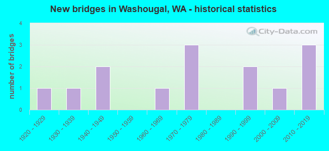
- New bridges - historical statistics
- 11920-1929
- 11930-1939
- 21940-1949
- 11960-1969
- 31970-1979
- 21990-1999
- 12000-2009
- 32010-2019


- Bridge Condition - Deck
- 83.3%Good
- 8.3%Satisfactory
- 8.3%Fair

- Bridge Condition - Superstructure
- 16.7%Very good
- 66.7%Good
- 16.7%Satisfactory

- Bridge Condition - Substructure
- 16.7%Very good
- 66.7%Good
- 8.3%Satisfactory
- 8.3%Fair

- Bridge Condition - Channel
- 66.7%Very good
- 33.3%Good
Find on map >> Show street view
Structure Number: 902A, Location: 6.3 E JCT SR 500 (Lat: 45.561556, Lng: -122.266778), Route carried "on" structure: State highway 14, Year Built: 1925, Status: Open, Structure Length: 1.34m (4.40ft), Average Daily Traffic: 5,404 (year 2019), Truck Traffic: 11%, Average Future Daily Traffic: 7,824 (year 2039), Design Load: H 20, Features Intersected: LAWTON CREEK
Minimum Vertical Clearance: 30+ m (98+ ft), Kilometerpoint: 33.635, Lanes on structure: 2, Base Highway Network: Yes, Owner: State Highway Agency, Approaching Roadway Width: 9.1m (29.9ft), Material/Design: Concrete continuous, Design/Construction: Slab, Number Of Spans In Main Unit: 2, Length of Maximum Span: 6.1m (20.0ft), Curb-To-Curb Width: 7.3m (24.0ft), Out-to-Out Width: 8.3m (27.2ft)
Condition: Deck: Good, Superstructure: Good, Substructure: Good, Channel: Very good, Operating Rating: 41.1 metric tons, Method Used To Determine Operating Rating: Load and Resistance Factor Rating (LRFR) rating reported by rating factor(RF) method using HL-93 loadings, Inventory Rating: 31.8 metric tons, Method Used To Determine Inventory Rating: Load and Resistance Factor Rating (LRFR) rating reported by rating factor(RF) method using HL-93 loadings, Structural Evaluation: Better than present minimum criteria, Deck Geometry: High priority of replacement, Waterway Adequacy: Equal to present desirable criteria, Approach Roadway Alignment: Equal to present desirable criteria, Length Of Structure Improvement: 1.34m (4.40ft), Designated Inspection Frequency: Every 24 months, Inspection Date: July 2021, Bridge Improvement Cost: $282,000, Roadway Improvement Cost: $56,000, Total Project Cost: $563,000 ( Estimate for 2014), Deck Structure Type: Concrete Cast-file-Place, Wearing Surface/Protective System: Wearing Surface: Bituminous, Membrane: Preformed Fabric
Find on map >> Show street view
Structure Number: 3606A, Location: 2.3 E JCT SR 14 (Lat: 45.608017, Lng: -122.344233), Route carried "on" structure: County highway 14000, Year Built: 1949, Status: Open, Structure Length: 4.39m (14.40ft), Average Daily Traffic: 5,175 (year 2017), Truck Traffic: 6%, Average Future Daily Traffic: 11,449 (year 2039), Design Load: HS 15, Features Intersected: LITTLE WASHOUGAL RIVER, Facility Carried by Structure: WASHOUGAL RIVER RD
Minimum Vertical Clearance: 30+ m (98+ ft), Kilometerpoint: 0.001, Lanes on structure: 2, Owner: County Highway Agency, Approaching Roadway Width: 7.3m (24.0ft), Skew: 3 degrees, Material/Design: Concrete continuous, Design/Construction: Tee Beam, Number Of Spans In Main Unit: 3, Length of Maximum Span: 18.3m (60.0ft), Curb-To-Curb Width: 7.9m (25.9ft), Out-to-Out Width: 9.1m (29.9ft)
Condition: Deck: Good, Superstructure: Good, Substructure: Good, Channel: Very good, Operating Rating: 26.2 metric tons, Method Used To Determine Operating Rating: Load and Resistance Factor Rating (LRFR) rating reported by rating factor(RF) method using HL-93 loadings, Inventory Rating: 20.1 metric tons, Method Used To Determine Inventory Rating: Load and Resistance Factor Rating (LRFR) rating reported by rating factor(RF) method using HL-93 loadings, Structural Evaluation: Somewhat better than minimum adequacy, Deck Geometry: High priority of replacement, Waterway Adequacy: Equal to present desirable criteria, Approach Roadway Alignment: Equal to present desirable criteria, Length Of Structure Improvement: 4.69m (15.39ft), Designated Inspection Frequency: Every 24 months, Inspection Date: July 2021, Bridge Improvement Cost: $2,341,000, Roadway Improvement Cost: $468,000, Total Project Cost: $4,682,000 ( Estimate for 2014), Deck Structure Type: Concrete Cast-file-Place, Wearing Surface/Protective System: Wearing Surface: Bituminous, Membrane: Built-up
Find on map >> Show street view
Structure Number: 7597A, Location: 0.2 E JCT SR 14 (Lat: 45.580333, Lng: -122.354017), Route carried "on" structure: County highway 14000, Year Built: 1965, Status: Open, Structure Length: 5.70m (18.70ft), Average Daily Traffic: 8,727 (year 2017), Truck Traffic: 8%, Average Future Daily Traffic: 8,380 (year 2038), Design Load: HS 20, Features Intersected: BURLINGTON NORTHERN RY, Facility Carried by Structure: WASHOUGAL RIVER RD
Minimum Vertical Clearance: 30+ m (98+ ft), Kilometerpoint: 0.001, Lanes on structure: 2, Owner: City or Municipal Highway Agency, Maintenance Responsibility: County Highway Agency, Approaching Roadway Width: 9.8m (32.2ft), Skew: 3 degrees, Material/Design: Prestressed concrete continuous, Design/Construction: Stringer/Multi-beam, Number Of Spans In Main Unit: 3, Length of Maximum Span: 20.1m (65.9ft), Curb or Sidewalk Widths: Left: 1.2m (3.9ft), Right: 1.2m (3.9ft), Curb-To-Curb Width: 9.1m (29.9ft), Out-to-Out Width: 11.9m (39.0ft)
Condition: Deck: Fair, Superstructure: Satisfactory, Substructure: Satisfactory, Operating Rating: 61.7 metric tons, Method Used To Determine Operating Rating: Load and Resistance Factor (LRFR), Inventory Rating: 37.2 metric tons, Method Used To Determine Inventory Rating: Load and Resistance Factor (LRFR), Structural Evaluation: Equal to present minimum criteria, Deck Geometry: High priority of corrective action, Underclear: Equal to present minimum criteria, Approach Roadway Alignment: Equal to present minimum criteria, Length Of Structure Improvement: 6.00m (19.69ft), Designated Inspection Frequency: Every 24 months, Inspection Date: December 2021, Bridge Improvement Cost: $2,994,000, Roadway Improvement Cost: $599,000, Total Project Cost: $5,989,000 ( Estimate for 2014), Deck Structure Type: Concrete Cast-file-Place, Wearing Surface/Protective System: Wearing Surface: Monolithic Concrete
Find on map >> Show street view
Structure Number: 9275A, Location: 2.1 E JCT SR 500 (Lat: 45.574806, Lng: -122.343500), Route carried "on" structure: State highway 14, Year Built: 1972, Status: Open, Structure Length: 6.83m (22.41ft), Average Daily Traffic: 19,882 (year 2019), Truck Traffic: 10%, Average Future Daily Traffic: 28,789 (year 2039), Design Load: HS 20+Mod, Features Intersected: 27TH ST & BN RY
Minimum Vertical Clearance: 30+ m (98+ ft), Kilometerpoint: 26.924, Lanes on structure: 2, Lanes under structure: 2, Base Highway Network: Yes, Owner: State Highway Agency, Approaching Roadway Width: 14.0m (45.9ft), Material/Design: Prestressed concrete continuous, Design/Construction: Stringer/Multi-beam, Number Of Spans In Main Unit: 3, Length of Maximum Span: 29.6m (97.1ft), Curb or Sidewalk Widths: Left: 0.2m (0.7ft), Right: 0.2m (0.7ft), Curb-To-Curb Width: 12.8m (42.0ft), Out-to-Out Width: 13.7m (44.9ft)
Condition: Deck: Good, Superstructure: Good, Substructure: Good, Operating Rating: 77.1 metric tons, Method Used To Determine Operating Rating: Load Factor (LF), Inventory Rating: 45.4 metric tons, Method Used To Determine Inventory Rating: Load Factor (LF), Structural Evaluation: Better than present minimum criteria, Deck Geometry: Somewhat better than minimum adequacy, Underclear: Somewhat better than minimum adequacy, Approach Roadway Alignment: Equal to present desirable criteria, Length Of Structure Improvement: 6.83m (22.41ft), Designated Inspection Frequency: Every 48 months, Inspection Date: July 2020, Bridge Improvement Cost: $2,150,000, Roadway Improvement Cost: $430,000, Total Project Cost: $4,301,000 ( Estimate for 2014), Deck Structure Type: Concrete Cast-file-Place, Wearing Surface/Protective System: Wearing Surface: Monolithic Concrete
Find on map >> Show street view
Structure Number: 9275B, Location: 3.5 E JCT SR 500 (Lat: 45.571417, Lng: -122.315889), Route carried "on" structure: State highway 14, Year Built: 1972, Status: Open, Structure Length: 1.98m (6.50ft), Average Daily Traffic: 6,308 (year 2019), Truck Traffic: 13%, Average Future Daily Traffic: 9,133 (year 2039), Design Load: HS 20+Mod, Features Intersected: GIBBONS CR
Minimum Vertical Clearance: 30+ m (98+ ft), Kilometerpoint: 29.113, Lanes on structure: 2, Base Highway Network: Yes, Owner: State Highway Agency, Approaching Roadway Width: 14.6m (47.9ft), Material/Design: Concrete continuous, Design/Construction: Slab, Number Of Spans In Main Unit: 3, Length of Maximum Span: 14.3m (46.9ft), Curb or Sidewalk Widths: Left: 0.2m (0.7ft), Right: 0.2m (0.7ft), Curb-To-Curb Width: 12.2m (40.0ft), Out-to-Out Width: 13.1m (43.0ft)
Condition: Deck: Good, Superstructure: Good, Substructure: Good, Channel: Very good, Operating Rating: 68.9 metric tons, Method Used To Determine Operating Rating: Load Factor (LF), Inventory Rating: 40.8 metric tons, Method Used To Determine Inventory Rating: Load Factor (LF), Structural Evaluation: Better than present minimum criteria, Deck Geometry: Somewhat better than minimum adequacy, Waterway Adequacy: Equal to present desirable criteria, Approach Roadway Alignment: Equal to present desirable criteria, Length Of Structure Improvement: 1.98m (6.50ft), Designated Inspection Frequency: Every 48 months, Inspection Date: May 2020, Bridge Improvement Cost: $650,000, Roadway Improvement Cost: $130,000, Total Project Cost: $1,300,000 ( Estimate for 2014), Deck Structure Type: Concrete Cast-file-Place, Wearing Surface/Protective System: Wearing Surface: Monolithic Concrete
Find on map >> Show street view
Structure Number: 9275C, Location: 4.1 E JCT SR 500 (Lat: 45.571472, Lng: -122.301944), Route carried "on" structure: State highway 14, Year Built: 1972, Status: Open, Structure Length: 11.64m (38.19ft), Average Daily Traffic: 6,308 (year 2019), Truck Traffic: 13%, Average Future Daily Traffic: 9,133 (year 2039), Design Load: HS 20+Mod, Features Intersected: BN RR
Minimum Vertical Clearance: 30+ m (98+ ft), Kilometerpoint: 30.207, Lanes on structure: 2, Base Highway Network: Yes, Owner: State Highway Agency, Approaching Roadway Width: 12.2m (40.0ft), Skew: 5 degrees, Material/Design: Prestressed concrete continuous, Design/Construction: Stringer/Multi-beam, Number Of Spans In Main Unit: 4, Length of Maximum Span: 32.3m (106.0ft), Curb or Sidewalk Widths: Left: 0.2m (0.7ft), Right: 0.2m (0.7ft), Curb-To-Curb Width: 12.2m (40.0ft), Out-to-Out Width: 13.1m (43.0ft)
Condition: Deck: Satisfactory, Superstructure: Good, Substructure: Good, Operating Rating: 87.1 metric tons, Method Used To Determine Operating Rating: Load Factor (LF), Inventory Rating: 52.6 metric tons, Method Used To Determine Inventory Rating: Load Factor (LF), Structural Evaluation: Better than present minimum criteria, Deck Geometry: Somewhat better than minimum adequacy, Underclear: Superior to present desirable criteria, Approach Roadway Alignment: Equal to present desirable criteria, Length Of Structure Improvement: 11.64m (38.19ft), Designated Inspection Frequency: Every 48 months, Inspection Date: April 2018, Bridge Improvement Cost: $3,209,000, Roadway Improvement Cost: $642,000, Total Project Cost: $6,418,000 ( Estimate for 2014), Deck Structure Type: Concrete Cast-file-Place, Wearing Surface/Protective System: Wearing Surface: Monolithic Concrete
Find on map >> Show street view
Structure Number: 18105C, Location: 0.4 E JCT SR 500 (Lat: 45.580597, Lng: -122.377931), Route carried "on" structure: State highway 14, Year Built: 2012, Status: Open, Structure Length: 2.74m (8.99ft), Average Daily Traffic: 23,986 (year 2019), Truck Traffic: 8%, Average Future Daily Traffic: 34,731 (year 2039), Design Load: HL 93, Features Intersected: SECOND STREET
Minimum Vertical Clearance: 30+ m (98+ ft), Kilometerpoint: 24.140, Lanes on structure: 3, Lanes under structure: 2, Base Highway Network: Yes, Owner: State Highway Agency, Approaching Roadway Width: 23.2m (76.1ft), Skew: 30 degrees, Material/Design: Prestressed concrete, Design/Construction: Stringer/Multi-beam, Number Of Spans In Main Unit: 1, Length of Maximum Span: 26.2m (86.0ft), Curb-To-Curb Width: 23.2m (76.1ft), Out-to-Out Width: 24.4m (80.1ft)
Condition: Deck: Good, Superstructure: Very good, Substructure: Very good, Operating Rating: 69.3 metric tons, Method Used To Determine Operating Rating: Load and Resistance Factor Rating (LRFR) rating reported by rating factor(RF) method using HL-93 loadings, Inventory Rating: 51.8 metric tons, Method Used To Determine Inventory Rating: Load and Resistance Factor Rating (LRFR) rating reported by rating factor(RF) method using HL-93 loadings, Structural Evaluation: Equal to present desirable criteria, Deck Geometry: Superior to present desirable criteria, Underclear: Equal to present minimum criteria, Approach Roadway Alignment: Equal to present desirable criteria, Length Of Structure Improvement: 2.74m (8.99ft), Designated Inspection Frequency: Every 48 months, Inspection Date: Febuary 2019, Bridge Improvement Cost: $1,404,000, Roadway Improvement Cost: $281,000, Total Project Cost: $2,808,000 ( Estimate for 2014), Deck Structure Type: Concrete Cast-file-Place, Wearing Surface/Protective System: Wearing Surface: Monolithic Concrete, Deck Protection: Epoxy Coated Reinforcing
Find on map >> Show street view
Structure Number: 82025, Location: 1.9 E JCT SR 140 (Lat: 45.574797, Lng: -122.315450), Route carried "on" structure: County highway 34400, Year Built: 1940, Status: Posted for load, Structure Length: 0.85m (2.79ft), Average Daily Traffic: 1,637 (year 2018), Truck Traffic: 7%, Average Future Daily Traffic: 2,000 (year 2038), Design Load: HS 25 or greater, Features Intersected: GIBBONS CREEK, Facility Carried by Structure: SE EVERGREEN WAY
Minimum Vertical Clearance: 30+ m (98+ ft), Kilometerpoint: 0.001, Lanes on structure: 2, Owner: County Highway Agency, Approaching Roadway Width: 9.1m (29.9ft), Material/Design: Concrete, Design/Construction: Stringer/Multi-beam, Number Of Spans In Main Unit: 1, Length of Maximum Span: 8.5m (27.9ft), Curb-To-Curb Width: 7.5m (24.6ft), Out-to-Out Width: 8.4m (27.6ft)
Condition: Deck: Good, Superstructure: Good, Substructure: Good, Channel: Good, Operating Rating: 27.9 metric tons, Method Used To Determine Operating Rating: Load and Resistance Factor Rating (LRFR) rating reported by rating factor(RF) method using HL-93 loadings, Inventory Rating: 21.4 metric tons, Method Used To Determine Inventory Rating: Load and Resistance Factor Rating (LRFR) rating reported by rating factor(RF) method using HL-93 loadings, Structural Evaluation: Somewhat better than minimum adequacy, Deck Geometry: Meets minimum limits, Waterway Adequacy: Equal to present minimum criteria, Approach Roadway Alignment: Equal to present desirable criteria, Bridge Posting: Required (Relationship of Operating Rating to Maximum Legal Load: 20.0 - 29.9% below), Length Of Structure Improvement: 1.16m (3.81ft), Designated Inspection Frequency: Every 24 months, Inspection Date: Febuary 2020, Bridge Improvement Cost: $578,000, Roadway Improvement Cost: $116,000, Total Project Cost: $1,155,000 ( Estimate for 2014), Deck Structure Type: Concrete Cast-file-Place, Wearing Surface/Protective System: Wearing Surface: Bituminous
Find on map >> Show street view
Structure Number: 84389, Location: 0.39 NW JCT SR140 (Lat: 45.608906, Lng: -122.351975), Route carried "on" structure: County highway 93450, Year Built: 1930, Year Reconstructed: 1959, Status: Open, Structure Length: 1.55m (5.09ft), Average Daily Traffic: 1,249 (year 2016), Truck Traffic: 1%, Average Future Daily Traffic: 4,555 (year 2037), Design Load: HS 15, Features Intersected: LITTLE WASHOUGAL RIVER, Facility Carried by Structure: SE BLAIR ROAD
Minimum Vertical Clearance: 30+ m (98+ ft), Kilometerpoint: 0.001, Lanes on structure: 2, Owner: County Highway Agency, Approaching Roadway Width: 9.1m (29.9ft), Material/Design: Prestressed concrete, Design/Construction: Stringer/Multi-beam, Number Of Spans In Main Unit: 1, Length of Maximum Span: 15.2m (49.9ft), Curb-To-Curb Width: 8.0m (26.2ft), Out-to-Out Width: 9.4m (30.8ft)
Condition: Deck: Good, Superstructure: Satisfactory, Substructure: Fair, Channel: Good, Operating Rating: 53.8 metric tons, Method Used To Determine Operating Rating: Load and Resistance Factor Rating (LRFR) rating reported by rating factor(RF) method using HL-93 loadings, Inventory Rating: 34.7 metric tons, Method Used To Determine Inventory Rating: Load and Resistance Factor Rating (LRFR) rating reported by rating factor(RF) method using HL-93 loadings, Structural Evaluation: Somewhat better than minimum adequacy, Deck Geometry: Meets minimum limits, Waterway Adequacy: Better than present minimum criteria, Approach Roadway Alignment: Equal to present minimum criteria, Length Of Structure Improvement: 1.86m (6.10ft), Designated Inspection Frequency: Every 24 months, Inspection Date: July 2021, Bridge Improvement Cost: $927,000, Roadway Improvement Cost: $185,000, Total Project Cost: $1,854,000 ( Estimate for 2014), Deck Structure Type: Concrete Cast-file-Place, Wearing Surface/Protective System: Wearing Surface: Bituminous
Find on map >> Show street view
Structure Number: 86028, Location: .3 E JCT SR14 (Lat: 45.602817, Lng: -122.353767), Route carried "on" structure: City street 14000, Year Built: 1993, Status: Open, Structure Length: 7.62m (25.00ft), Average Daily Traffic: 6,484 (year 2017), Truck Traffic: 5%, Average Future Daily Traffic: 13,545 (year 2038), Design Load: HS 25 or greater, Features Intersected: WASHOUGAL RIVER, Facility Carried by Structure: WASHOUGAL RIVER RD
Minimum Vertical Clearance: 30+ m (98+ ft), Kilometerpoint: 0.001, Lanes on structure: 2, Owner: City or Municipal Highway Agency, Maintenance Responsibility: County Highway Agency, Approaching Roadway Width: 9.8m (32.2ft), Skew: 9 degrees, Material/Design: Prestressed concrete continuous, Design/Construction: Stringer/Multi-beam, Number Of Spans In Main Unit: 3, Length of Maximum Span: 32.0m (105.0ft), Curb or Sidewalk Widths: Left: 2.0m (6.6ft), Right: 2.0m (6.6ft), Curb-To-Curb Width: 9.8m (32.2ft), Out-to-Out Width: 13.7m (44.9ft)
Condition: Deck: Good, Superstructure: Good, Substructure: Good, Channel: Good, Operating Rating: 68.9 metric tons, Method Used To Determine Operating Rating: Load and Resistance Factor (LRFR), Inventory Rating: 41.7 metric tons, Method Used To Determine Inventory Rating: Load and Resistance Factor (LRFR), Structural Evaluation: Better than present minimum criteria, Deck Geometry: Meets minimum limits, Waterway Adequacy: Equal to present desirable criteria, Approach Roadway Alignment: Equal to present desirable criteria, Length Of Structure Improvement: 7.92m (25.98ft), Designated Inspection Frequency: Every 24 months, Inspection Date: December 2021, Bridge Improvement Cost: $3,952,000, Roadway Improvement Cost: $790,000, Total Project Cost: $7,904,000 ( Estimate for 2014), Deck Structure Type: Concrete Cast-file-Place, Wearing Surface/Protective System: Wearing Surface: Monolithic Concrete, Deck Protection: Epoxy Coated Reinforcing
Find on map >> Show street view
Structure Number: 86441, Location: INT WASHOUGAL R RD (Lat: 45.625250, Lng: -122.282833), Route carried "on" structure: County highway 32870, Year Built: 1998, Status: Open, Structure Length: 3.84m (12.60ft), Average Daily Traffic: 1,003 (year 2021), Truck Traffic: 1%, Average Future Daily Traffic: 2,404 (year 2043), Design Load: HS 20, Features Intersected: WASHOUGAL RIVER, Facility Carried by Structure: NE VERNON RD
Minimum Vertical Clearance: 30+ m (98+ ft), Kilometerpoint: 0.001, Lanes on structure: 2, Owner: County Highway Agency, Approaching Roadway Width: 10.4m (34.1ft), Material/Design: Prestressed concrete continuous, Design/Construction: Tee Beam, Number Of Spans In Main Unit: 1, Length of Maximum Span: 38.4m (126.0ft), Curb-To-Curb Width: 9.9m (32.5ft), Out-to-Out Width: 10.2m (33.5ft)
Condition: Deck: Good, Superstructure: Good, Substructure: Good, Channel: Very good, Operating Rating: 32.4 metric tons, Method Used To Determine Operating Rating: Load and Resistance Factor Rating (LRFR) rating reported by rating factor(RF) method using HL-93 loadings, Inventory Rating: 24.9 metric tons, Method Used To Determine Inventory Rating: Load and Resistance Factor Rating (LRFR) rating reported by rating factor(RF) method using HL-93 loadings, Structural Evaluation: Equal to present minimum criteria, Deck Geometry: Somewhat better than minimum adequacy, Waterway Adequacy: Equal to present desirable criteria, Approach Roadway Alignment: High priority of corrective action, Length Of Structure Improvement: 4.15m (13.62ft), Designated Inspection Frequency: Every 24 months, Inspection Date: December 2021, Bridge Improvement Cost: $2,067,000, Roadway Improvement Cost: $413,000, Total Project Cost: $4,134,000 ( Estimate for 2014), Deck Structure Type: Other, Wearing Surface/Protective System: Wearing Surface: Bituminous, Membrane: Preformed Fabric
Find on map >> Show street view
Structure Number: 8772, Location: 0.2 miles south of J St (Lat: 45.582203, Lng: -122.317214), Route carried "on" structure: City street 1385, Year Built: 2008, Status: Open, Structure Length: 1.13m (3.71ft), Average Daily Traffic: 250 (year 2016), Truck Traffic: 2%, Average Future Daily Traffic: 425 (year 2040), Design Load: HL 93, Features Intersected: J St and G St, Facility Carried by Structure: Fairway Drive
Minimum Vertical Clearance: 30+ m (98+ ft), Kilometerpoint: 0.001, Lanes on structure: 2, Owner: City or Municipal Highway Agency, Approaching Roadway Width: 11.0m (36.1ft), Material/Design: Concrete, Design/Construction: Culvert, Number Of Spans In Main Unit: 1, Length of Maximum Span: 10.7m (35.1ft), Curb or Sidewalk Widths: Left: 2.0m (6.6ft), Right: 2.0m (6.6ft), Curb-To-Curb Width: 11.0m (36.1ft), Out-to-Out Width: 15.5m (50.9ft)
Condition: Channel: Very good, Culverts: Fair, Operating Rating: 55.3 metric tons, Method Used To Determine Operating Rating: Load and Resistance Factor (LRFR), Inventory Rating: 37.2 metric tons, Method Used To Determine Inventory Rating: Load and Resistance Factor (LRFR), Structural Evaluation: Somewhat better than minimum adequacy, Deck Geometry: Equal to present desirable criteria, Waterway Adequacy: Equal to present desirable criteria, Approach Roadway Alignment: Equal to present desirable criteria, Length Of Structure Improvement: 1.43m (4.69ft), Designated Inspection Frequency: Every 24 months, Inspection Date: December 2021, Bridge Improvement Cost: $714,000, Roadway Improvement Cost: $143,000, Total Project Cost: $1,429,000 ( Estimate for 2014)
Find on map >> Show street view
Structure Number: 88499, Location: 5.2 E JCT SR 14 (Lat: 45.625542, Lng: -122.307581), Route carried "on" structure: County highway 14000, Year Built: 2012, Status: Open, Structure Length: 1.95m (6.40ft), Average Daily Traffic: 3,400 (year 2018), Truck Traffic: 12%, Average Future Daily Traffic: 5,500 (year 2038), Design Load: HS 25 or greater, Features Intersected: Cougar Creek, Facility Carried by Structure: Washougal River Rd
Minimum Vertical Clearance: 30+ m (98+ ft), Kilometerpoint: 0.001, Lanes on structure: 2, Owner: County Highway Agency, Approaching Roadway Width: 9.8m (32.2ft), Skew: 2 degrees, Material/Design: Concrete, Design/Construction: Stringer/Multi-beam, Number Of Spans In Main Unit: 1, Length of Maximum Span: 18.6m (61.0ft), Curb-To-Curb Width: 9.8m (32.2ft), Out-to-Out Width: 11.0m (36.1ft)
Condition: Deck: Good, Superstructure: Very good, Substructure: Very good, Channel: Very good, Operating Rating: 69.7 metric tons, Method Used To Determine Operating Rating: Load and Resistance Factor Rating (LRFR) rating reported by rating factor(RF) method using HL-93 loadings, Inventory Rating: 53.8 metric tons, Method Used To Determine Inventory Rating: Load and Resistance Factor Rating (LRFR) rating reported by rating factor(RF) method using HL-93 loadings, Structural Evaluation: Equal to present desirable criteria, Deck Geometry: Meets minimum limits, Waterway Adequacy: Equal to present desirable criteria, Approach Roadway Alignment: Equal to present desirable criteria, Designated Inspection Frequency: Every 24 months, Inspection Date: September 2020, Deck Structure Type: Concrete Cast-file-Place, Wearing Surface/Protective System: Wearing Surface: Monolithic Concrete, Deck Protection: Galvanized Reinforcing
Find on map >> Show street view
Structure Number: 18105C, Location: 0.5 E JCT SR 500 (Lat: 45.580597, Lng: -122.377931), Route carried "under" structure: State highway 500, Year Built: 2012, Structure Length: 0. m, Average Daily Traffic: 3,275 (year 2019), Truck Traffic: 6%, Features Intersected: SECOND STREET, Facility Carried by Structure: SR 14
Minimum Vertical Clearance: 5.61m (18.41ft), Kilometerpoint: 33.523, Lanes on structure: 3, Lanes under structure: 2, Material/Design: Prestressed concrete, Design/Construction: Stringer/Multi-beam, Length of Maximum Span: 26.2m (86.0ft)