Bridge Statistics for Warrenton, Virginia (VA)
Condition, Traffic, Stress, Structural Evaluation, Project Costs
- National Bridge Inventory (NBI) Statistics
- 49Number of bridges
- 325ft / 98.9mTotal length
- $242,000Total costs
- 533,221Total average daily traffic
- 31,895Total average daily truck traffic
- National Bridge Inventory (NBI) Registered Bridges for Warrenton
- No street view available for this location
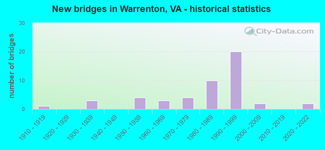
- New bridges - historical statistics
- 11910-1919
- 31930-1939
- 41950-1959
- 31960-1969
- 41970-1979
- 101980-1989
- 201990-1999
- 22000-2009
- 22020-2022

- Reconstructed bridges - Historical Statistics
- 11940-1949
- 01950-1959
- 11960-1969
- 01970-1979
- 01980-1989
- 51990-1999
- 02000-2009
- 12010-2019


- Bridge Condition - Deck
- 5.0%Excellent
- 40.0%Good
- 40.0%Satisfactory
- 15.0%Fair

- Bridge Condition - Superstructure
- 5.0%Excellent
- 5.0%Very good
- 40.0%Good
- 35.0%Satisfactory
- 15.0%Fair

- Bridge Condition - Substructure
- 5.0%Very good
- 40.0%Good
- 40.0%Satisfactory
- 15.0%Fair

- Bridge Condition - Channel
- 41.4%Good
- 44.8%Satisfactory
- 13.8%Fair

- Bridge Condition - Culverts
- 66.7%Good
- 33.3%Satisfactory
Find on map >> Show street view
Structure Number: 7108, Location: .10Fr1105&.52 To 15/29Byp (Lat: 38.693772, Lng: -77.788819), Route carried "on" structure: US 15, Year Built: 1939, Year Reconstructed: 1953, Status: Open, Structure Length: 0.70m (2.30ft), Average Daily Traffic: 4,630 (year 2020), Truck Traffic: 3%, Average Future Daily Traffic: 6,483 (year 2040), Design Load: HS 20, Features Intersected: Turkey Run
Minimum Vertical Clearance: 30+ m (98+ ft), Kilometerpoint: 0.386, Lanes on structure: 2, Base Highway Network: Yes, Owner: State Highway Agency, Approaching Roadway Width: 11.9m (39.0ft), Material/Design: Concrete, Design/Construction: Slab, Number Of Spans In Main Unit: 1, Length of Maximum Span: 6.1m (20.0ft), Curb-To-Curb Width: 13.4m (44.0ft), Out-to-Out Width: 14.0m (45.9ft)
Condition: Deck: Fair, Superstructure: Fair, Substructure: Satisfactory, Channel: Fair, Operating Rating: 44.5 metric tons, Method Used To Determine Operating Rating: Load Factor (LF), Inventory Rating: 32.7 metric tons, Method Used To Determine Inventory Rating: Load Factor (LF), Structural Evaluation: Somewhat better than minimum adequacy, Deck Geometry: Superior to present desirable criteria, Waterway Adequacy: Equal to present desirable criteria, Approach Roadway Alignment: Equal to present desirable criteria, Designated Inspection Frequency: Every 24 months, Inspection Date: May 2020, Deck Structure Type: Concrete Cast-file-Place, Wearing Surface/Protective System: Wearing Surface: Bituminous
Find on map >> Show street view
Structure Number: 7112, Location: 1.35 Fr 17 & .85 To 605 (Lat: 38.729042, Lng: -77.777950), Route carried "on" structure: US 15, Year Built: 1986, Status: Open, Structure Length: 2.56m (8.40ft), Average Daily Traffic: 23,825 (year 2020), Truck Traffic: 9%, Average Future Daily Traffic: 33,356 (year 2040), Design Load: HS 20, Features Intersected: Cedar Run
Minimum Vertical Clearance: 30+ m (98+ ft), Kilometerpoint: 298.019, Lanes on structure: 2, Base Highway Network: Yes, Owner: State Highway Agency, Approaching Roadway Width: 7.3m (24.0ft), Material/Design: Concrete, Design/Construction: Slab, Number Of Spans In Main Unit: 4, Length of Maximum Span: 6.7m (22.0ft), Curb-To-Curb Width: 11.7m (38.4ft), Out-to-Out Width: 12.7m (41.7ft)
Condition: Deck: Satisfactory, Superstructure: Satisfactory, Substructure: Satisfactory, Channel: Satisfactory, Operating Rating: 89.8 metric tons, Method Used To Determine Operating Rating: Load Factor (LF), Inventory Rating: 60.8 metric tons, Method Used To Determine Inventory Rating: Load Factor (LF), Structural Evaluation: Equal to present minimum criteria, Deck Geometry: Equal to present minimum criteria, Waterway Adequacy: Superior to present desirable criteria, Approach Roadway Alignment: Equal to present desirable criteria, Designated Inspection Frequency: Every 24 months, Inspection Date: September 2021, Deck Structure Type: Concrete Precast Panels, Wearing Surface/Protective System: Wearing Surface: Bituminous, Deck Protection: Epoxy Coated Reinforcing
Find on map >> Show street view
Structure Number: 7122, Location: .22 Fr 15BusN&.85 To 605 (Lat: 38.729217, Lng: -77.778147), Route carried "on" structure: US 15, Year Built: 1955, Year Reconstructed: 1997, Status: Open, Structure Length: 2.44m (8.01ft), Average Daily Traffic: 23,825 (year 2020), Truck Traffic: 8%, Average Future Daily Traffic: 33,356 (year 2040), Design Load: HS 20, Features Intersected: Cedar Run
Minimum Vertical Clearance: 30+ m (98+ ft), Kilometerpoint: 298.019, Lanes on structure: 5, Base Highway Network: Yes, Owner: State Highway Agency, Approaching Roadway Width: 24.7m (81.0ft), Material/Design: Concrete, Design/Construction: Slab, Number Of Spans In Main Unit: 4, Length of Maximum Span: 6.1m (20.0ft), Curb-To-Curb Width: 24.7m (81.0ft), Out-to-Out Width: 25.6m (84.0ft)
Condition: Deck: Satisfactory, Superstructure: Satisfactory, Substructure: Satisfactory, Channel: Satisfactory, Operating Rating: 64.4 metric tons, Method Used To Determine Operating Rating: Load Factor (LF), Inventory Rating: 39.0 metric tons, Method Used To Determine Inventory Rating: Load Factor (LF), Structural Evaluation: Equal to present minimum criteria, Deck Geometry: Superior to present desirable criteria, Waterway Adequacy: Equal to present desirable criteria, Approach Roadway Alignment: Equal to present desirable criteria, Designated Inspection Frequency: Every 24 months, Inspection Date: Febuary 2022, Deck Structure Type: Concrete Cast-file-Place, Wearing Surface/Protective System: Wearing Surface: Bituminous
Find on map >> Show street view
Structure Number: 7127, Location: .10Fr1105&.52 To 15/29Byp (Lat: 38.693439, Lng: -77.783222), Route carried "on" structure: US 15, Year Built: 1966, Status: Open, Structure Length: 0.67m (2.20ft), Average Daily Traffic: 23,825 (year 2020), Truck Traffic: 9%, Average Future Daily Traffic: 33,356 (year 2040), Design Load: HS 20, Features Intersected: Turkey Run
Minimum Vertical Clearance: 30+ m (98+ ft), Kilometerpoint: 0.402, Lanes on structure: 2, Base Highway Network: Yes, Owner: State Highway Agency, Approaching Roadway Width: 7.9m (25.9ft), Material/Design: Concrete, Design/Construction: Culvert, Number Of Spans In Main Unit: 2, Length of Maximum Span: 3.0m (9.8ft)
Condition: Channel: Satisfactory, Culverts: Satisfactory, Operating Rating: 73.5 metric tons, Method Used To Determine Operating Rating: Load Factor (LF), Inventory Rating: 43.5 metric tons, Method Used To Determine Inventory Rating: Load Factor (LF), Structural Evaluation: Equal to present minimum criteria, Waterway Adequacy: Equal to present desirable criteria, Approach Roadway Alignment: Equal to present desirable criteria, Designated Inspection Frequency: Every 24 months, Inspection Date: May 2020
Find on map >> Show street view
Structure Number: 7128, Location: 1.10 Fr 17 & 1.10 To 605 (Lat: 38.726844, Lng: -77.780772), Route carried "on" structure: Ramp US 15, Year Built: 1986, Status: Open, Structure Length: 6.77m (22.21ft), Average Daily Traffic: 13,367 (year 2020), Truck Traffic: 1%, Average Future Daily Traffic: 18,715 (year 2040), Design Load: HS 20, Features Intersected: 15/29 Bypass
Minimum Vertical Clearance: 30+ m (98+ ft), Kilometerpoint: 297.681, Lanes on structure: 1, Lanes under structure: 4, Base Highway Network: Yes, Owner: State Highway Agency, Approaching Roadway Width: 11.6m (38.1ft), Skew: 3 degrees, Material/Design: Steel continuous, Design/Construction: Stringer/Multi-beam, Number Of Spans In Main Unit: 2, Length of Maximum Span: 34.7m (113.8ft), Curb-To-Curb Width: 11.7m (38.4ft), Out-to-Out Width: 12.7m (41.7ft)
Condition: Deck: Satisfactory, Superstructure: Good, Substructure: Satisfactory, Operating Rating: 89.8 metric tons, Method Used To Determine Operating Rating: Load and Resistance Factor (LRFR), Inventory Rating: 80.7 metric tons, Method Used To Determine Inventory Rating: Load and Resistance Factor (LRFR), Structural Evaluation: Equal to present minimum criteria, Deck Geometry: Superior to present desirable criteria, Underclear: Equal to present minimum criteria, Approach Roadway Alignment: Equal to present desirable criteria, Designated Inspection Frequency: Every 24 months, Inspection Date: Febuary 2022, Deck Structure Type: Concrete Cast-file-Place
Find on map >> Show street view
Structure Number: 713, Location: .35 Fr 17 & .85 To 605 (Lat: 38.728881, Lng: -77.777528), Route carried "on" structure: Ramp US 15, Year Built: 1986, Status: Open, Structure Length: 2.99m (9.81ft), Average Daily Traffic: 13,367 (year 2020), Truck Traffic: 1%, Average Future Daily Traffic: 18,715 (year 2040), Design Load: HS 20, Features Intersected: Cedar Run
Minimum Vertical Clearance: 30+ m (98+ ft), Kilometerpoint: 297.935, Lanes on structure: 2, Base Highway Network: Yes, Owner: State Highway Agency, Approaching Roadway Width: 11.6m (38.1ft), Material/Design: Concrete, Design/Construction: Slab, Number Of Spans In Main Unit: 4, Length of Maximum Span: 8.2m (26.9ft), Curb-To-Curb Width: 11.7m (38.4ft), Out-to-Out Width: 12.8m (42.0ft)
Condition: Deck: Satisfactory, Superstructure: Satisfactory, Substructure: Satisfactory, Channel: Good, Operating Rating: 89.8 metric tons, Method Used To Determine Operating Rating: Load and Resistance Factor (LRFR), Inventory Rating: 70.8 metric tons, Method Used To Determine Inventory Rating: Load and Resistance Factor (LRFR), Structural Evaluation: Equal to present minimum criteria, Deck Geometry: Superior to present desirable criteria, Waterway Adequacy: Equal to present desirable criteria, Approach Roadway Alignment: Equal to present desirable criteria, Designated Inspection Frequency: Every 24 months, Inspection Date: June 2020, Deck Structure Type: Concrete Cast-file-Place
Find on map >> Show street view
Structure Number: 7142, Location: .90 Fr 628 &1.0 To 29 Bus (Lat: 38.741164, Lng: -77.808531), Route carried "on" structure: State highway 17, Year Built: 1988, Year Reconstructed: 1997, Status: Open, Structure Length: 0.85m (2.79ft), Average Daily Traffic: 20,057 (year 2020), Truck Traffic: 13%, Average Future Daily Traffic: 28,080 (year 2040), Design Load: HS 20, Features Intersected: Towser Branch
Minimum Vertical Clearance: 30+ m (98+ ft), Kilometerpoint: 350.907, Lanes on structure: 6, Base Highway Network: Yes, Owner: State Highway Agency, Approaching Roadway Width: 24.1m (79.1ft), Skew: 2 degrees, Material/Design: Concrete, Design/Construction: Culvert, Number Of Spans In Main Unit: 4, Length of Maximum Span: 2.1m (6.9ft)
Condition: Channel: Satisfactory, Culverts: Good, Operating Rating: 61.7 metric tons, Method Used To Determine Operating Rating: Load Factor (LF), Inventory Rating: 37.2 metric tons, Method Used To Determine Inventory Rating: Load Factor (LF), Structural Evaluation: Better than present minimum criteria, Waterway Adequacy: Equal to present desirable criteria, Approach Roadway Alignment: Equal to present desirable criteria, Designated Inspection Frequency: Every 24 months, Inspection Date: January 2022
Find on map >> Show street view
Structure Number: 7143, Location: 1.0 Fr 628 &.90 To 29 Bus (Lat: 38.739911, Lng: -77.807617), Route carried "on" structure: US 17, Year Built: 1988, Year Reconstructed: 1997, Status: Open, Structure Length: 0.61m (2.00ft), Average Daily Traffic: 8,782 (year 2020), Truck Traffic: 2%, Average Future Daily Traffic: 9,660 (year 2040), Design Load: HS 20, Features Intersected: Cattail Branch
Minimum Vertical Clearance: 30+ m (98+ ft), Kilometerpoint: 350.746, Lanes on structure: 5, Base Highway Network: Yes, Owner: State Highway Agency, Approaching Roadway Width: 24.4m (80.1ft), Skew: 5 degrees, Material/Design: Concrete, Design/Construction: Culvert, Number Of Spans In Main Unit: 2, Length of Maximum Span: 2.7m (8.9ft)
Condition: Channel: Satisfactory, Culverts: Good, Operating Rating: 89.8 metric tons, Method Used To Determine Operating Rating: Load Factor (LF), Inventory Rating: 89.8 metric tons, Method Used To Determine Inventory Rating: Load Factor (LF), Structural Evaluation: Better than present minimum criteria, Waterway Adequacy: Equal to present desirable criteria, Approach Roadway Alignment: Equal to present desirable criteria, Designated Inspection Frequency: Every 24 months, Inspection Date: January 2022
Find on map >> Show street view
Structure Number: 7245, Location: 2.01 Fr 17Bus&1.69 To 681 (Lat: 38.710650, Lng: -77.844806), Route carried "on" structure: US 211, Year Built: 1930, Year Reconstructed: 1990, Status: Open, Structure Length: 1.30m (4.27ft), Average Daily Traffic: 6,366 (year 2020), Truck Traffic: 2%, Average Future Daily Traffic: 8,912 (year 2040), Design Load: HS 20, Features Intersected: Great Run, Facility Carried by Structure: Lee Hwy WBL
Minimum Vertical Clearance: 30+ m (98+ ft), Kilometerpoint: 89.412, Lanes on structure: 2, Base Highway Network: Yes, Owner: State Highway Agency, Approaching Roadway Width: 6.7m (22.0ft), Material/Design: Concrete, Design/Construction: Slab, Number Of Spans In Main Unit: 1, Length of Maximum Span: 12.2m (40.0ft), Curb-To-Curb Width: 12.8m (42.0ft), Out-to-Out Width: 13.8m (45.3ft)
Condition: Deck: Satisfactory, Superstructure: Satisfactory, Substructure: Satisfactory, Channel: Good, Operating Rating: 85.3 metric tons, Method Used To Determine Operating Rating: Load Factor (LF), Inventory Rating: 50.8 metric tons, Method Used To Determine Inventory Rating: Load Factor (LF), Structural Evaluation: Equal to present minimum criteria, Deck Geometry: Equal to present desirable criteria, Waterway Adequacy: Equal to present desirable criteria, Approach Roadway Alignment: Equal to present desirable criteria, Designated Inspection Frequency: Every 24 months, Inspection Date: November 2020, Deck Structure Type: Concrete Precast Panels, Wearing Surface/Protective System: Wearing Surface: Bituminous, Membrane: Epoxy, Deck Protection: Epoxy Coated Reinforcing
Find on map >> Show street view
Structure Number: 725, Location: 1.56 WCL Wrntn &1.69 681 (Lat: 38.710381, Lng: -77.844661), Route carried "on" structure: US 211, Year Built: 1975, Status: Open, Structure Length: 0.98m (3.22ft), Average Daily Traffic: 6,366 (year 2020), Truck Traffic: 2%, Average Future Daily Traffic: 8,912 (year 2040), Design Load: HS 20, Features Intersected: Great Run, Facility Carried by Structure: Lee Highway EBL
Minimum Vertical Clearance: 30+ m (98+ ft), Kilometerpoint: 89.412, Lanes on structure: 2, Base Highway Network: Yes, Owner: State Highway Agency, Approaching Roadway Width: 7.3m (24.0ft), Skew: 1 degrees, Material/Design: Concrete, Design/Construction: Culvert, Number Of Spans In Main Unit: 3, Length of Maximum Span: 3.0m (9.8ft)
Condition: Channel: Good, Culverts: Satisfactory, Operating Rating: 89.8 metric tons, Method Used To Determine Operating Rating: Load Factor (LF), Inventory Rating: 89.8 metric tons, Method Used To Determine Inventory Rating: Load Factor (LF), Structural Evaluation: Equal to present minimum criteria, Waterway Adequacy: Superior to present desirable criteria, Approach Roadway Alignment: Equal to present desirable criteria, Designated Inspection Frequency: Every 24 months, Inspection Date: December 2021
Find on map >> Show street view
Structure Number: 7269, Location: .90 Fr 672 & 1.1 To 628 (Lat: 38.759964, Lng: -77.792631), Route carried "on" structure: County highway 605, Year Built: 1919, Status: Open, Structure Length: 1.04m (3.41ft), Average Daily Traffic: 1,111 (year 2020), Truck Traffic: 1%, Average Future Daily Traffic: 1,269 (year 2040), Design Load: HS 20, Features Intersected: Cedar Run, Facility Carried by Structure: Airlie Road
Minimum Vertical Clearance: 30+ m (98+ ft), Kilometerpoint: 1.760, Lanes on structure: 1, Owner: State Highway Agency, Approaching Roadway Width: 5.5m (18.0ft), Skew: 3 degrees, Material/Design: Concrete, Design/Construction: Arch - Deck, Number Of Spans In Main Unit: 1, Length of Maximum Span: 9.4m (30.8ft), Curb-To-Curb Width: 3.6m (11.8ft), Out-to-Out Width: 4.5m (14.8ft)
Condition: Deck: Fair, Superstructure: Fair, Substructure: Fair, Channel: Good, Operating Rating: 44.5 metric tons, Method Used To Determine Operating Rating: Field evaluation and documented engineering judgment, Inventory Rating: 32.7 metric tons, Method Used To Determine Inventory Rating: Field evaluation and documented engineering judgment, Structural Evaluation: Somewhat better than minimum adequacy, Deck Geometry: High priority of replacement, Waterway Adequacy: Better than present minimum criteria, Approach Roadway Alignment: Better than present minimum criteria, Length Of Structure Improvement: 1.04m (3.41ft), Designated Inspection Frequency: Every 24 months, Inspection Date: March 2020, Bridge Improvement Cost: $100,000, Roadway Improvement Cost: $20,000, Total Project Cost: $145,000, Deck Structure Type: Concrete Cast-file-Place, Wearing Surface/Protective System: Wearing Surface: Bituminous
Find on map >> Show street view
Structure Number: 7297, Location: .16 Fr 605 & .08 To 17 (Lat: 38.763806, Lng: -77.811525), Route carried "on" structure: County highway 628, Year Built: 1988, Status: Open, Structure Length: 1.01m (3.31ft), Average Daily Traffic: 2,075 (year 2020), Truck Traffic: 2%, Average Future Daily Traffic: 2,588 (year 2040), Design Load: HS 20, Features Intersected: Cedar Run, Facility Carried by Structure: Blantyre Road
Minimum Vertical Clearance: 30+ m (98+ ft), Kilometerpoint: 8.206, Lanes on structure: 2, Owner: State Highway Agency, Approaching Roadway Width: 11.3m (37.1ft), Skew: 1 degrees, Material/Design: Concrete, Design/Construction: Culvert, Number Of Spans In Main Unit: 3, Length of Maximum Span: 3.0m (9.8ft)
Condition: Channel: Satisfactory, Culverts: Good, Operating Rating: 89.8 metric tons, Method Used To Determine Operating Rating: Load Factor (LF), Inventory Rating: 89.8 metric tons, Method Used To Determine Inventory Rating: Load Factor (LF), Structural Evaluation: Better than present minimum criteria, Waterway Adequacy: Equal to present desirable criteria, Approach Roadway Alignment: Equal to present desirable criteria, Designated Inspection Frequency: Every 24 months, Inspection Date: December 2020
Find on map >> Show street view
Structure Number: 7316, Location: .91 Fr 674 & .35 To 779 (Lat: 38.675714, Lng: -77.747714), Route carried "on" structure: County highway 643, Year Built: 1964, Status: Open, Structure Length: 0.98m (3.22ft), Average Daily Traffic: 3,814 (year 2020), Truck Traffic: 4%, Average Future Daily Traffic: 4,195 (year 2040), Design Load: HS 20, Features Intersected: Turkey Run, Facility Carried by Structure: Meetze Road
Minimum Vertical Clearance: 30+ m (98+ ft), Kilometerpoint: 10.722, Lanes on structure: 2, Owner: State Highway Agency, Approaching Roadway Width: 6.7m (22.0ft), Skew: 1 degrees, Material/Design: Concrete, Design/Construction: Culvert, Number Of Spans In Main Unit: 3, Length of Maximum Span: 3.4m (11.2ft)
Condition: Channel: Satisfactory, Culverts: Satisfactory, Operating Rating: 68.0 metric tons, Method Used To Determine Operating Rating: Load Factor (LF), Inventory Rating: 40.8 metric tons, Method Used To Determine Inventory Rating: Load Factor (LF), Structural Evaluation: Equal to present minimum criteria, Waterway Adequacy: Better than present minimum criteria, Approach Roadway Alignment: Equal to present desirable criteria, Designated Inspection Frequency: Every 24 months, Inspection Date: October 2021
Find on map >> Show street view
Structure Number: 732, Location: .25 Fr 672 & .40 To15 Bus (Lat: 38.709294, Lng: -77.780428), Route carried "on" structure: County highway 643, Year Built: 1988, Status: Open, Structure Length: 6.17m (20.24ft), Average Daily Traffic: 6,893 (year 2020), Truck Traffic: 4%, Average Future Daily Traffic: 8,569 (year 2040), Design Load: HS 20, Features Intersected: 15/29 Bypass NBL & SBL, Facility Carried by Structure: Meetze Road
Minimum Vertical Clearance: 30+ m (98+ ft), Kilometerpoint: 16.380, Lanes on structure: 4, Lanes under structure: 4, Owner: State Highway Agency, Approaching Roadway Width: 21.0m (68.9ft), Skew: 20 degrees, Material/Design: Steel continuous, Design/Construction: Stringer/Multi-beam, Number Of Spans In Main Unit: 2, Length of Maximum Span: 30.5m (100.1ft), Curb-To-Curb Width: 20.9m (68.6ft), Out-to-Out Width: 26.8m (87.9ft)
Condition: Deck: Good, Superstructure: Satisfactory, Substructure: Satisfactory, Operating Rating: 59.9 metric tons, Method Used To Determine Operating Rating: Load and Resistance Factor (LRFR), Inventory Rating: 46.3 metric tons, Method Used To Determine Inventory Rating: Load and Resistance Factor (LRFR), Structural Evaluation: Equal to present minimum criteria, Deck Geometry: Superior to present desirable criteria, Underclear: Somewhat better than minimum adequacy, Approach Roadway Alignment: Equal to present desirable criteria, Designated Inspection Frequency: Every 24 months, Inspection Date: June 2020, Deck Structure Type: Concrete Cast-file-Place, Wearing Surface/Protective System: Deck Protection: Epoxy Coated Reinforcing
Find on map >> Show street view
Structure Number: 735, Location: 2.21 Fr 616 & .19 To 643 (Lat: 38.680636, Lng: -77.761806), Route carried "on" structure: County highway 674, Year Built: 1950, Year Reconstructed: 2001, Status: Open, Structure Length: 0.79m (2.59ft), Average Daily Traffic: 668 (year 2015), Average Future Daily Traffic: 970 (year 2040), Design Load: HS 20, Features Intersected: Turkey Run, Facility Carried by Structure: Green Road
Minimum Vertical Clearance: 30+ m (98+ ft), Kilometerpoint: 9.823, Lanes on structure: 2, Owner: State Highway Agency, Approaching Roadway Width: 5.8m (19.0ft), Material/Design: Concrete, Design/Construction: Slab, Number Of Spans In Main Unit: 1, Length of Maximum Span: 7.3m (24.0ft), Curb-To-Curb Width: 7.2m (23.6ft), Out-to-Out Width: 7.3m (24.0ft)
Condition: Deck: Good, Superstructure: Good, Substructure: Good, Channel: Good, Operating Rating: 89.8 metric tons, Method Used To Determine Operating Rating: Allowable Stress (AS), Inventory Rating: 70.8 metric tons, Method Used To Determine Inventory Rating: Allowable Stress (AS), Structural Evaluation: Better than present minimum criteria, Deck Geometry: Meets minimum limits, Waterway Adequacy: Somewhat better than minimum adequacy, Approach Roadway Alignment: Better than present minimum criteria, Designated Inspection Frequency: Every 24 months, Inspection Date: Febuary 2022, Deck Structure Type: Concrete Precast Panels, Wearing Surface/Protective System: Wearing Surface: Bituminous, Membrane: Epoxy, Deck Protection: Epoxy Coated Reinforcing
Find on map >> Show street view
Structure Number: 7357, Location: 1.90 Fr 680 & .53 To 691 (Lat: 38.718569, Lng: -77.863767), Route carried "on" structure: County highway 678, Year Built: 1964, Status: Open, Structure Length: 1.37m (4.49ft), Average Daily Traffic: 1,641 (year 2020), Truck Traffic: 1%, Average Future Daily Traffic: 1,649 (year 2040), Design Load: HS 20, Features Intersected: Great Run, Facility Carried by Structure: Old Waterloo Road
Minimum Vertical Clearance: 30+ m (98+ ft), Kilometerpoint: 4.541, Lanes on structure: 2, Owner: State Highway Agency, Approaching Roadway Width: 6.7m (22.0ft), Skew: 4 degrees, Material/Design: Concrete, Design/Construction: Culvert, Number Of Spans In Main Unit: 3, Length of Maximum Span: 4.3m (14.1ft)
Condition: Channel: Satisfactory, Culverts: Satisfactory, Operating Rating: 65.3 metric tons, Method Used To Determine Operating Rating: Load Factor (LF), Inventory Rating: 39.0 metric tons, Method Used To Determine Inventory Rating: Load Factor (LF), Structural Evaluation: Equal to present minimum criteria, Waterway Adequacy: Better than present minimum criteria, Approach Roadway Alignment: Better than present minimum criteria, Designated Inspection Frequency: Every 24 months, Inspection Date: October 2020
Find on map >> Show street view
Structure Number: 7443, Location: .08 Fr 17 & .20 To End (Lat: 38.765389, Lng: -77.816553), Route carried "on" structure: County highway 787, Year Built: 1953, Year Reconstructed: 2017, Status: Open, Structure Length: 0.91m (2.99ft), Average Daily Traffic: 100 (year 2019), Average Future Daily Traffic: 130 (year 2040), Design Load: HS 20, Features Intersected: Cedar Run, Facility Carried by Structure: Watery Mountain Rd
Minimum Vertical Clearance: 30+ m (98+ ft), Kilometerpoint: 0.425, Lanes on structure: 2, Owner: State Highway Agency, Approaching Roadway Width: 4.3m (14.1ft), Material/Design: Steel, Design/Construction: Stringer/Multi-beam, Number Of Spans In Main Unit: 1, Length of Maximum Span: 9.1m (29.9ft), Curb or Sidewalk Widths: Left: 0.3m (1.0ft), Right: 0.3m (1.0ft), Curb-To-Curb Width: 7.2m (23.6ft), Out-to-Out Width: 7.8m (25.6ft)
Condition: Deck: Good, Superstructure: Very good, Substructure: Good, Channel: Good, Operating Rating: 76.2 metric tons, Method Used To Determine Operating Rating: Load and Resistance Factor (LRFR), Inventory Rating: 58.1 metric tons, Method Used To Determine Inventory Rating: Load and Resistance Factor (LRFR), Structural Evaluation: Better than present minimum criteria, Deck Geometry: Somewhat better than minimum adequacy, Waterway Adequacy: Somewhat better than minimum adequacy, Approach Roadway Alignment: Somewhat better than minimum adequacy, Length Of Structure Improvement: 0.98m (3.22ft), Designated Inspection Frequency: Every 24 months, Inspection Date: March 2021, Bridge Improvement Cost: $50,000, Roadway Improvement Cost: $5,000, Total Project Cost: $70,000 ( Estimate for 2014), Deck Structure Type: Wood or Timber
Find on map >> Show street view
Structure Number: 7444, Location: .60 Fr 682 & .85 To 681 (Lat: 38.693644, Lng: -77.830403), Route carried "on" structure: County highway 802, Year Built: 1950, Year Reconstructed: 1968, Status: Open, Structure Length: 2.01m (6.59ft), Average Daily Traffic: 2,010 (year 2020), Average Future Daily Traffic: 2,211 (year 2040), Design Load: HS 20, Features Intersected: Great Run, Facility Carried by Structure: Springs Road
Minimum Vertical Clearance: 30+ m (98+ ft), Kilometerpoint: 6.819, Lanes on structure: 2, Owner: State Highway Agency, Approaching Roadway Width: 6.7m (22.0ft), Material/Design: Concrete, Design/Construction: Slab, Number Of Spans In Main Unit: 3, Length of Maximum Span: 6.7m (22.0ft), Curb or Sidewalk Widths: Left: 0.3m (1.0ft), Right: 0.3m (1.0ft), Curb-To-Curb Width: 9.1m (29.9ft), Out-to-Out Width: 9.8m (32.2ft)
Condition: Deck: Fair, Superstructure: Fair, Substructure: Fair, Channel: Fair, Operating Rating: 37.2 metric tons, Method Used To Determine Operating Rating: Load and Resistance Factor (LRFR), Inventory Rating: 28.1 metric tons, Method Used To Determine Inventory Rating: Load and Resistance Factor (LRFR), Structural Evaluation: Somewhat better than minimum adequacy, Deck Geometry: Meets minimum limits, Waterway Adequacy: Equal to present minimum criteria, Approach Roadway Alignment: Better than present minimum criteria, Designated Inspection Frequency: Every 24 months, Inspection Date: Febuary 2021, Deck Structure Type: Concrete Cast-file-Place, Wearing Surface/Protective System: Wearing Surface: Bituminous
Find on map >> Show street view
Structure Number: 7447, Location: .32 Fr 1133 & .22 To 682 (Lat: 38.700472, Lng: -77.821347), Route carried "on" structure: County highway 802, Year Built: 1937, Status: Open, Structure Length: 0.98m (3.22ft), Average Daily Traffic: 1,736 (year 2020), Truck Traffic: 2%, Average Future Daily Traffic: 2,422 (year 2040), Design Load: HS 20, Features Intersected: Branch Great Run, Facility Carried by Structure: Springs Road
Minimum Vertical Clearance: 30+ m (98+ ft), Kilometerpoint: 8.148, Lanes on structure: 2, Owner: State Highway Agency, Approaching Roadway Width: 6.4m (21.0ft), Material/Design: Concrete, Design/Construction: Slab, Number Of Spans In Main Unit: 2, Length of Maximum Span: 4.9m (16.1ft), Curb-To-Curb Width: 7.2m (23.6ft), Out-to-Out Width: 7.8m (25.6ft)
Condition: Deck: Satisfactory, Superstructure: Satisfactory, Substructure: Fair, Channel: Fair, Operating Rating: 44.5 metric tons, Method Used To Determine Operating Rating: Load Factor (LF), Inventory Rating: 32.7 metric tons, Method Used To Determine Inventory Rating: Field evaluation and documented engineering judgment, Structural Evaluation: Somewhat better than minimum adequacy, Deck Geometry: High priority of corrective action, Waterway Adequacy: Equal to present minimum criteria, Approach Roadway Alignment: Equal to present desirable criteria, Length Of Structure Improvement: 0.98m (3.22ft), Designated Inspection Frequency: Every 24 months, Inspection Date: June 2020, Bridge Improvement Cost: $25,000, Roadway Improvement Cost: $1,000, Total Project Cost: $27,000 ( Estimate for 2014), Deck Structure Type: Concrete Cast-file-Place, Wearing Surface/Protective System: Wearing Surface: Bituminous
Find on map >> Show street view
Structure Number: 22533, Location: .04 FR 29 & .60 TO 211 (Lat: 38.727531, Lng: -77.790761), Route carried "on" structure: Business US 15, Year Built: 1978, Status: Open, Structure Length: 1.10m (3.61ft), Average Daily Traffic: 6,171 (year 2020), Truck Traffic: 1%, Average Future Daily Traffic: 6,788 (year 2040), Design Load: HS 20, Features Intersected: WHITES MILL RUN, Facility Carried by Structure: BLACKWELL ROAD
Minimum Vertical Clearance: 30+ m (98+ ft), Kilometerpoint: 0.032, Lanes on structure: 3, Owner: Town or Township Highway Agency, Approaching Roadway Width: 14.6m (47.9ft), Skew: 3 degrees, Material/Design: Concrete, Design/Construction: Culvert, Number Of Spans In Main Unit: 3, Length of Maximum Span: 3.7m (12.1ft)
Condition: Channel: Good, Culverts: Good, Operating Rating: 65.3 metric tons, Method Used To Determine Operating Rating: Load Factor (LF), Inventory Rating: 39.0 metric tons, Method Used To Determine Inventory Rating: Load Factor (LF), Structural Evaluation: Better than present minimum criteria, Waterway Adequacy: Equal to present minimum criteria, Approach Roadway Alignment: Better than present minimum criteria, Designated Inspection Frequency: Every 24 months, Inspection Date: May 2020
Find on map >> Show street view
Structure Number: 22534, Location: .45 FR 15 & .03 WCL. WARR (Lat: 38.715692, Lng: -77.816186), Route carried "on" structure: US 211, Year Built: 1975, Status: Open, Structure Length: 1.95m (6.40ft), Average Daily Traffic: 19,576 (year 2020), Truck Traffic: 2%, Average Future Daily Traffic: 21,990 (year 2040), Design Load: HS 20, Features Intersected: CEMETERY RUN
Minimum Vertical Clearance: 30+ m (98+ ft), Kilometerpoint: 2.993, Lanes on structure: 2, Base Highway Network: Yes, Owner: Town or Township Highway Agency, Approaching Roadway Width: 10.1m (33.1ft), Skew: 4 degrees, Material/Design: Concrete, Design/Construction: Culvert, Number Of Spans In Main Unit: 4, Length of Maximum Span: 4.9m (16.1ft)
Condition: Channel: Good, Culverts: Good, Operating Rating: 63.5 metric tons, Method Used To Determine Operating Rating: Load Factor (LF), Inventory Rating: 38.1 metric tons, Method Used To Determine Inventory Rating: Load Factor (LF), Structural Evaluation: Better than present minimum criteria, Waterway Adequacy: Equal to present minimum criteria, Approach Roadway Alignment: Equal to present desirable criteria, Designated Inspection Frequency: Every 24 months, Inspection Date: May 2020
Find on map >> Show street view
Structure Number: 22535, Location: .15 FR 15 & .33 WCL. WARR (Lat: 38.716769, Lng: -77.810592), Route carried "on" structure: US 211, Year Built: 1975, Status: Open, Structure Length: 1.10m (3.61ft), Average Daily Traffic: 19,576 (year 2020), Truck Traffic: 2%, Average Future Daily Traffic: 21,990 (year 2040), Design Load: HS 20, Features Intersected: CEMETERY RUN
Minimum Vertical Clearance: 30+ m (98+ ft), Kilometerpoint: 2.510, Lanes on structure: 2, Base Highway Network: Yes, Owner: Town or Township Highway Agency, Approaching Roadway Width: 13.4m (44.0ft), Skew: 4 degrees, Material/Design: Concrete, Design/Construction: Culvert, Number Of Spans In Main Unit: 3, Length of Maximum Span: 3.7m (12.1ft)
Condition: Channel: Satisfactory, Culverts: Satisfactory, Operating Rating: 61.7 metric tons, Method Used To Determine Operating Rating: Load Factor (LF), Inventory Rating: 37.2 metric tons, Method Used To Determine Inventory Rating: Load Factor (LF), Structural Evaluation: Equal to present minimum criteria, Waterway Adequacy: Equal to present minimum criteria, Approach Roadway Alignment: Equal to present desirable criteria, Designated Inspection Frequency: Every 24 months, Inspection Date: May 2020
Find on map >> Show street view
Structure Number: 23685, Location: .40 Fr 522 & 1.90 To 638 (Lat: 38.755931, Lng: -78.095903), Route carried "on" structure: County highway 729, Year Built: 1993, Status: Open, Structure Length: 0.98m (3.22ft), Average Daily Traffic: 519 (year 2020), Average Future Daily Traffic: 727 (year 2040), Design Load: HS 20, Features Intersected: Hickman Run, Facility Carried by Structure: Ben Venue Road
Minimum Vertical Clearance: 30+ m (98+ ft), Kilometerpoint: 19.705, Lanes on structure: 2, Owner: State Highway Agency, Approaching Roadway Width: 6.7m (22.0ft), Material/Design: Concrete, Design/Construction: Culvert, Number Of Spans In Main Unit: 3, Length of Maximum Span: 3.0m (9.8ft)
Condition: Channel: Satisfactory, Culverts: Good, Operating Rating: 63.5 metric tons, Method Used To Determine Operating Rating: Field evaluation and documented engineering judgment, Inventory Rating: 38.1 metric tons, Method Used To Determine Inventory Rating: Field evaluation and documented engineering judgment, Structural Evaluation: Better than present minimum criteria, Waterway Adequacy: Equal to present minimum criteria, Approach Roadway Alignment: Equal to present desirable criteria, Designated Inspection Frequency: Every 24 months, Inspection Date: June 2021
Find on map >> Show street view
Structure Number: 23686, Location: 0.24 TO 866E-0.06 TO 866W (Lat: 36.674622, Lng: -79.480706), Route carried "on" structure: County highway 865, Year Built: 1993, Status: Open, Structure Length: 1.30m (4.27ft), Average Daily Traffic: 132 (year 2015), Average Future Daily Traffic: 148 (year 2040), Design Load: HS 20+Mod, Features Intersected: Sandy Creek, Facility Carried by Structure: Sandy Creek Road
Minimum Vertical Clearance: 30+ m (98+ ft), Kilometerpoint: 2.961, Lanes on structure: 2, Owner: State Highway Agency, Approaching Roadway Width: 6.1m (20.0ft), Skew: 1 degrees, Material/Design: Concrete, Design/Construction: Culvert, Number Of Spans In Main Unit: 4, Length of Maximum Span: 3.1m (10.2ft)
Condition: Channel: Satisfactory, Culverts: Good, Operating Rating: 89.8 metric tons, Method Used To Determine Operating Rating: Load Factor (LF), Inventory Rating: 65.3 metric tons, Method Used To Determine Inventory Rating: Load Factor (LF), Structural Evaluation: Better than present minimum criteria, Waterway Adequacy: Equal to present minimum criteria, Approach Roadway Alignment: Equal to present desirable criteria, Designated Inspection Frequency: Every 24 months, Inspection Date: June 2020
Find on map >> Show street view
Structure Number: 24751, Location: .20FrWalkerDr & .15To 890 (Lat: 38.717450, Lng: -77.781511), Route carried "on" structure: County highway 678, Year Built: 1996, Status: Open, Structure Length: 7.07m (23.20ft), Average Daily Traffic: 2,239 (year 2015), Truck Traffic: 1%, Average Future Daily Traffic: 3,358 (year 2040), Design Load: HS 20, Features Intersected: 15/29 Bypass, Facility Carried by Structure: Academy Hill Road
Minimum Vertical Clearance: 30+ m (98+ ft), Kilometerpoint: 9.525, Lanes on structure: 2, Lanes under structure: 6, Owner: State Highway Agency, Approaching Roadway Width: 9.8m (32.2ft), Material/Design: Steel continuous, Design/Construction: Stringer/Multi-beam, Number Of Spans In Main Unit: 2, Length of Maximum Span: 35.1m (115.2ft), Curb-To-Curb Width: 9.5m (31.2ft), Out-to-Out Width: 10.5m (34.4ft)
Condition: Deck: Good, Superstructure: Good, Substructure: Good, Operating Rating: 69.9 metric tons, Method Used To Determine Operating Rating: Load and Resistance Factor (LRFR), Inventory Rating: 53.5 metric tons, Method Used To Determine Inventory Rating: Load and Resistance Factor (LRFR), Structural Evaluation: Better than present minimum criteria, Deck Geometry: Meets minimum limits, Underclear: Equal to present minimum criteria, Approach Roadway Alignment: Equal to present desirable criteria, Designated Inspection Frequency: Every 24 months, Inspection Date: January 2021, Deck Structure Type: Concrete Cast-file-Place, Wearing Surface/Protective System: Deck Protection: Epoxy Coated Reinforcing
Find on map >> Show street view
Structure Number: 24769, Location: 1.0 Fr 17 Bus&1.15 To 605 (Lat: 38.727242, Lng: -77.783075), Route carried "on" structure: Business US 15, Year Built: 1997, Status: Open, Structure Length: 6.77m (22.21ft), Average Daily Traffic: 13,367 (year 2020), Truck Traffic: 1%, Average Future Daily Traffic: 18,715 (year 2040), Design Load: HS 20+Mod, Features Intersected: 17 Spur
Minimum Vertical Clearance: 30.18m (99.02ft), Kilometerpoint: 297.295, Lanes on structure: 2, Lanes under structure: 6, Base Highway Network: Yes, Owner: State Highway Agency, Approaching Roadway Width: 15.2m (49.9ft), Skew: 1 degrees, Material/Design: Steel continuous, Design/Construction: Stringer/Multi-beam, Number Of Spans In Main Unit: 2, Length of Maximum Span: 33.5m (109.9ft), Curb-To-Curb Width: 15.8m (51.8ft), Out-to-Out Width: 16.9m (55.4ft)
Condition: Deck: Good, Superstructure: Good, Substructure: Good, Operating Rating: 57.6 metric tons, Method Used To Determine Operating Rating: Load Factor (LF), Inventory Rating: 34.2 metric tons, Method Used To Determine Inventory Rating: Load Factor (LF), Structural Evaluation: Better than present minimum criteria, Deck Geometry: Superior to present desirable criteria, Approach Roadway Alignment: Equal to present desirable criteria, Designated Inspection Frequency: Every 24 months, Inspection Date: March 2021, Deck Structure Type: Concrete Cast-file-Place, Wearing Surface/Protective System: Deck Protection: Epoxy Coated Reinforcing
Find on map >> Show street view
Structure Number: 24771, Location: .09OakTreeLn&.07CardnalLn (Lat: 38.735094, Lng: -77.796264), Route carried "on" structure: City street 1462, Year Built: 1997, Status: Open, Structure Length: 6.77m (22.21ft), Average Daily Traffic: 11,894 (year 2008), Truck Traffic: 1%, Average Future Daily Traffic: 1,155 (year 2033), Design Load: HS 20, Features Intersected: 17 Spur, Facility Carried by Structure: Hastings Lane
Minimum Vertical Clearance: 30+ m (98+ ft), Kilometerpoint: 6.500, Lanes on structure: 2, Lanes under structure: 4, Base Highway Network: Yes, Owner: State Highway Agency, Approaching Roadway Width: 9.1m (29.9ft), Skew: 1 degrees, Material/Design: Steel continuous, Design/Construction: Stringer/Multi-beam, Number Of Spans In Main Unit: 2, Length of Maximum Span: 33.5m (109.9ft), Curb or Sidewalk Widths: Left: 2.0m (6.6ft), Right: 2.0m (6.6ft), Curb-To-Curb Width: 9.1m (29.9ft), Out-to-Out Width: 13.9m (45.6ft)
Condition: Deck: Good, Superstructure: Good, Substructure: Good, Operating Rating: 88.9 metric tons, Method Used To Determine Operating Rating: Load Factor (LF), Inventory Rating: 61.7 metric tons, Method Used To Determine Inventory Rating: Load Factor (LF), Structural Evaluation: Better than present minimum criteria, Deck Geometry: Meets minimum limits, Underclear: Equal to present minimum criteria, Approach Roadway Alignment: Equal to present desirable criteria, Designated Inspection Frequency: Every 24 months, Inspection Date: January 2021, Deck Structure Type: Concrete Cast-file-Place, Wearing Surface/Protective System: Deck Protection: Epoxy Coated Reinforcing
Find on map >> Show street view
Structure Number: 24943, Location: 1.2 Fr 605 & 1.05 To 643 (Lat: 38.724017, Lng: -77.781197), Route carried "on" structure: US 15, Year Built: 1997, Status: Open, Structure Length: 7.19m (23.59ft), Average Daily Traffic: 23,825 (year 2020), Truck Traffic: 9%, Average Future Daily Traffic: 33,356 (year 2040), Design Load: HS 20, Features Intersected: Rte 17 Spur NBL
Minimum Vertical Clearance: 30+ m (98+ ft), Kilometerpoint: 296.989, Lanes on structure: 2, Lanes under structure: 2, Base Highway Network: Yes, Owner: State Highway Agency, Approaching Roadway Width: 12.2m (40.0ft), Skew: 4 degrees, Material/Design: Steel, Design/Construction: Stringer/Multi-beam, Number Of Spans In Main Unit: 3, Length of Maximum Span: 36.6m (120.1ft), Curb-To-Curb Width: 12.2m (40.0ft), Out-to-Out Width: 13.2m (43.3ft)
Condition: Deck: Good, Superstructure: Good, Substructure: Good, Operating Rating: 47.2 metric tons, Method Used To Determine Operating Rating: Load and Resistance Factor (LRFR), Inventory Rating: 36.3 metric tons, Method Used To Determine Inventory Rating: Load and Resistance Factor (LRFR), Structural Evaluation: Better than present minimum criteria, Deck Geometry: Better than present minimum criteria, Approach Roadway Alignment: Better than present minimum criteria, Designated Inspection Frequency: Every 24 months, Inspection Date: November 2021, Deck Structure Type: Concrete Cast-file-Place, Wearing Surface/Protective System: Deck Protection: Epoxy Coated Reinforcing
Find on map >> Show street view
Structure Number: 24958, Location: .3 Fr15Bus&.12 To War NCL (Lat: 38.732150, Lng: -77.790075), Route carried "on" structure: City street 672, Year Built: 1997, Status: Open, Structure Length: 6.90m (22.64ft), Average Daily Traffic: 1,106 (year 2014), Average Future Daily Traffic: 1,467 (year 2035), Design Load: HS 20, Features Intersected: Route 17 Spur, Facility Carried by Structure: Blackwell Road
Minimum Vertical Clearance: 30+ m (98+ ft), Kilometerpoint: 2.542, Lanes on structure: 2, Lanes under structure: 4, Owner: State Highway Agency, Approaching Roadway Width: 9.1m (29.9ft), Skew: 2 degrees, Material/Design: Steel continuous, Design/Construction: Stringer/Multi-beam, Number Of Spans In Main Unit: 2, Length of Maximum Span: 34.1m (111.9ft), Curb or Sidewalk Widths: Left: 2.0m (6.6ft), Right: 2.0m (6.6ft), Curb-To-Curb Width: 9.1m (29.9ft), Out-to-Out Width: 13.9m (45.6ft)
Condition: Deck: Satisfactory, Superstructure: Satisfactory, Substructure: Good, Operating Rating: 71.7 metric tons, Method Used To Determine Operating Rating: Load and Resistance Factor (LRFR), Inventory Rating: 55.3 metric tons, Method Used To Determine Inventory Rating: Load and Resistance Factor (LRFR), Structural Evaluation: Equal to present minimum criteria, Deck Geometry: Somewhat better than minimum adequacy, Underclear: Equal to present minimum criteria, Approach Roadway Alignment: Equal to present desirable criteria, Designated Inspection Frequency: Every 24 months, Inspection Date: November 2021, Deck Structure Type: Concrete Cast-file-Place, Wearing Surface/Protective System: Deck Protection: Epoxy Coated Reinforcing
Find on map >> Show street view
Structure Number: 25067, Location: .15 Fr 17 & 0.00 To End (Lat: 38.741419, Lng: -77.807400), Route carried "on" structure: ServiceOther road F1056, Year Built: 1997, Status: Open, Structure Length: 1.31m (4.30ft), Average Daily Traffic: 75 (year 2015), Truck Traffic: 1%, Average Future Daily Traffic: 84 (year 2040), Design Load: HS 20, Features Intersected: Stream, Facility Carried by Structure: Moffett Drive
Minimum Vertical Clearance: 30+ m (98+ ft), Kilometerpoint: 6.919, Lanes on structure: 2, Owner: State Highway Agency, Approaching Roadway Width: 5.5m (18.0ft), Material/Design: Concrete, Design/Construction: Culvert, Number Of Spans In Main Unit: 4, Length of Maximum Span: 3.0m (9.8ft)
Condition: Channel: Satisfactory, Culverts: Good, Operating Rating: 63.5 metric tons, Method Used To Determine Operating Rating: Load Factor (LF), Inventory Rating: 38.1 metric tons, Method Used To Determine Inventory Rating: Load Factor (LF), Structural Evaluation: Better than present minimum criteria, Waterway Adequacy: Better than present minimum criteria, Approach Roadway Alignment: Equal to present desirable criteria, Designated Inspection Frequency: Every 24 months, Inspection Date: November 2021
Find on map >> Show street view
Structure Number: 25104, Location: .25 Fr17SBL &.10 To17SBL (Lat: 38.738725, Lng: -77.807658), Route carried "on" structure: Spur US 17, Year Built: 1997, Status: Open, Structure Length: 1.07m (3.51ft), Average Daily Traffic: 10,028 (year 2020), Truck Traffic: 13%, Average Future Daily Traffic: 14,041 (year 2040), Design Load: HS 20, Features Intersected: Cattail Branch
Minimum Vertical Clearance: 30+ m (98+ ft), Kilometerpoint: 350.875, Lanes on structure: 2, Base Highway Network: Yes, Owner: State Highway Agency, Approaching Roadway Width: 13.1m (43.0ft), Skew: 4 degrees, Material/Design: Concrete, Design/Construction: Culvert, Number Of Spans In Main Unit: 2, Length of Maximum Span: 5.2m (17.1ft)
Condition: Channel: Good, Culverts: Good, Operating Rating: 89.8 metric tons, Method Used To Determine Operating Rating: Load Factor (LF), Inventory Rating: 89.8 metric tons, Method Used To Determine Inventory Rating: Load Factor (LF), Structural Evaluation: Better than present minimum criteria, Waterway Adequacy: Equal to present desirable criteria, Approach Roadway Alignment: Equal to present desirable criteria, Designated Inspection Frequency: Every 24 months, Inspection Date: March 2020
Find on map >> Show street view
Structure Number: 25106, Location: .05 Fr 15BusN&.25To15BypS (Lat: 38.726814, Lng: -77.785164), Route carried "on" structure: Ramp US 15, Year Built: 1997, Status: Open, Structure Length: 1.89m (6.20ft), Average Daily Traffic: 31,609 (year 2018), Truck Traffic: 1%, Average Future Daily Traffic: 11,000 (year 2035), Design Load: HS 20, Features Intersected: Branch Cedar Run
Minimum Vertical Clearance: 30+ m (98+ ft), Kilometerpoint: 332.677, Lanes on structure: 1, Base Highway Network: Yes, Owner: State Highway Agency, Approaching Roadway Width: 8.5m (27.9ft), Skew: 6 degrees, Material/Design: Concrete, Design/Construction: Culvert, Number Of Spans In Main Unit: 3, Length of Maximum Span: 6.1m (20.0ft)
Condition: Channel: Fair, Culverts: Good, Operating Rating: 89.8 metric tons, Method Used To Determine Operating Rating: Load Factor (LF), Inventory Rating: 64.4 metric tons, Method Used To Determine Inventory Rating: Load Factor (LF), Structural Evaluation: Better than present minimum criteria, Waterway Adequacy: Equal to present minimum criteria, Approach Roadway Alignment: Equal to present desirable criteria, Designated Inspection Frequency: Every 24 months, Inspection Date: December 2021
Find on map >> Show street view
Structure Number: 25111, Location: .17Fr17SpurS &.05 To 15NB (Lat: 38.726125, Lng: -77.782692), Route carried "on" structure: Ramp US 17, Year Built: 1997, Status: Open, Structure Length: 0.98m (3.22ft), Average Daily Traffic: 6,886 (year 2018), Truck Traffic: 13%, Average Future Daily Traffic: 16,705 (year 2037), Design Load: HS 20, Features Intersected: Branch Cedar Run
Minimum Vertical Clearance: 30+ m (98+ ft), Kilometerpoint: 1.609, Lanes on structure: 1, Base Highway Network: Yes, Owner: State Highway Agency, Approaching Roadway Width: 8.5m (27.9ft), Material/Design: Concrete, Design/Construction: Culvert, Number Of Spans In Main Unit: 3, Length of Maximum Span: 3.0m (9.8ft)
Condition: Channel: Satisfactory, Culverts: Good, Operating Rating: 89.8 metric tons, Method Used To Determine Operating Rating: Load Factor (LF), Inventory Rating: 64.4 metric tons, Method Used To Determine Inventory Rating: Load Factor (LF), Structural Evaluation: Better than present minimum criteria, Waterway Adequacy: Equal to present minimum criteria, Approach Roadway Alignment: Equal to present desirable criteria, Designated Inspection Frequency: Every 24 months, Inspection Date: November 2021
Find on map >> Show street view
Structure Number: 25113, Location: 1.10 Fr 628&1.30 To 672 (Lat: 38.737856, Lng: -77.805797), Route carried "on" structure: Ramp US 17, Year Built: 1997, Status: Open, Structure Length: 9.56m (31.36ft), Average Daily Traffic: 5,717 (year 2020), Truck Traffic: 13%, Average Future Daily Traffic: 7,480 (year 2040), Design Load: HS 20, Features Intersected: Rte 17 Bus. NBL & SBL
Minimum Vertical Clearance: 30+ m (98+ ft), Kilometerpoint: 350.440, Lanes on structure: 2, Lanes under structure: 4, Base Highway Network: Yes, Owner: State Highway Agency, Approaching Roadway Width: 12.2m (40.0ft), Skew: 5 degrees, Material/Design: Steel continuous, Design/Construction: Stringer/Multi-beam, Number Of Spans In Main Unit: 2, Length of Maximum Span: 47.2m (154.9ft), Curb-To-Curb Width: 12.2m (40.0ft), Out-to-Out Width: 13.2m (43.3ft)
Condition: Deck: Satisfactory, Superstructure: Good, Substructure: Satisfactory, Operating Rating: 73.5 metric tons, Method Used To Determine Operating Rating: Load and Resistance Factor (LRFR), Inventory Rating: 57.2 metric tons, Method Used To Determine Inventory Rating: Load and Resistance Factor (LRFR), Structural Evaluation: Equal to present minimum criteria, Deck Geometry: Superior to present desirable criteria, Underclear: Equal to present minimum criteria, Approach Roadway Alignment: Equal to present desirable criteria, Designated Inspection Frequency: Every 24 months, Inspection Date: November 2021, Deck Structure Type: Concrete Cast-file-Place, Wearing Surface/Protective System: Deck Protection: Epoxy Coated Reinforcing
Find on map >> Show street view
Structure Number: 26291, Location: .50 Fr 15 Bus&1.13 To 643 (Lat: 38.693589, Lng: -77.783467), Route carried "on" structure: US 15, Year Built: 1986, Status: Open, Structure Length: 0.64m (2.10ft), Average Daily Traffic: 47,651 (year 2020), Truck Traffic: 9%, Average Future Daily Traffic: 57,072 (year 2040), Design Load: HS 20, Features Intersected: Turkey Run
Minimum Vertical Clearance: 30+ m (98+ ft), Kilometerpoint: 293.803, Lanes on structure: 4, Base Highway Network: Yes, Owner: State Highway Agency, Approaching Roadway Width: 21.3m (69.9ft), Material/Design: Concrete, Design/Construction: Culvert, Number Of Spans In Main Unit: 2, Length of Maximum Span: 3.0m (9.8ft)
Condition: Channel: Good, Culverts: Satisfactory, Operating Rating: 89.8 metric tons, Method Used To Determine Operating Rating: Load Factor (LF), Inventory Rating: 89.8 metric tons, Method Used To Determine Inventory Rating: Load Factor (LF), Structural Evaluation: Equal to present minimum criteria, Waterway Adequacy: Equal to present desirable criteria, Approach Roadway Alignment: Equal to present desirable criteria, Designated Inspection Frequency: Every 24 months, Inspection Date: January 2022
Find on map >> Show street view
Structure Number: 2765, Location: .74 Fr 802 & .35 To End (Lat: 38.704186, Lng: -77.837808), Route carried "on" structure: County highway 682, Year Built: 2005, Status: Open, Structure Length: 1.04m (3.41ft), Average Daily Traffic: 119 (year 2015), Average Future Daily Traffic: 178 (year 2040), Design Load: HS 20, Features Intersected: Great Run, Facility Carried by Structure: Black Snake Lane
Minimum Vertical Clearance: 30+ m (98+ ft), Kilometerpoint: 0.563, Lanes on structure: 2, Owner: State Highway Agency, Approaching Roadway Width: 4.6m (15.1ft), Skew: 4 degrees, Material/Design: Concrete, Design/Construction: Slab, Number Of Spans In Main Unit: 1, Length of Maximum Span: 9.1m (29.9ft), Curb-To-Curb Width: 6.1m (20.0ft), Out-to-Out Width: 6.2m (20.3ft)
Condition: Deck: Good, Superstructure: Good, Substructure: Good, Channel: Good, Operating Rating: 89.8 metric tons, Method Used To Determine Operating Rating: Load Factor (LF), Inventory Rating: 59.0 metric tons, Method Used To Determine Inventory Rating: Load Factor (LF), Structural Evaluation: Better than present minimum criteria, Deck Geometry: Meets minimum limits, Waterway Adequacy: Equal to present minimum criteria, Approach Roadway Alignment: Equal to present desirable criteria, Designated Inspection Frequency: Every 24 months, Inspection Date: July 2021, Deck Structure Type: Concrete Precast Panels, Wearing Surface/Protective System: Wearing Surface: Bituminous, Membrane: Epoxy, Deck Protection: Epoxy Coated Reinforcing
Find on map >> Show street view
Structure Number: 27821, Location: .36 Fr 643 & .64 To End (Lat: 38.675108, Lng: -77.738661), Route carried "on" structure: County highway 779, Year Built: 2004, Status: Open, Structure Length: 0.88m (2.89ft), Average Daily Traffic: 243 (year 2015), Average Future Daily Traffic: 364 (year 2040), Design Load: HS 20, Features Intersected: Turkey Run, Facility Carried by Structure: Turkey Run Road
Minimum Vertical Clearance: 30+ m (98+ ft), Kilometerpoint: 0.579, Lanes on structure: 2, Owner: State Highway Agency, Approaching Roadway Width: 7.3m (24.0ft), Skew: 3 degrees, Material/Design: Concrete, Design/Construction: Culvert, Number Of Spans In Main Unit: 2, Length of Maximum Span: 4.3m (14.1ft)
Condition: Channel: Good, Culverts: Good, Operating Rating: 49.0 metric tons, Method Used To Determine Operating Rating: Load Factor (LF), Inventory Rating: 29.0 metric tons, Method Used To Determine Inventory Rating: Load Factor (LF), Structural Evaluation: Better than present minimum criteria, Waterway Adequacy: Equal to present minimum criteria, Approach Roadway Alignment: Equal to present desirable criteria, Designated Inspection Frequency: Every 24 months, Inspection Date: Febuary 2021
Find on map >> Show street view
Structure Number: 30174, Location: 0.2 Fr 1105 & 0.1 to 882 (Lat: 38.686361, Lng: -77.787153), Route carried "on" structure: Business US 29, Year Built: 2020, Status: Open, Structure Length: 5.28m (17.32ft), Average Daily Traffic: 11,013 (year 2018), Truck Traffic: 3%, Average Future Daily Traffic: 9,050 (year 2036), Design Load: HL 93, Features Intersected: Rte.15 / 17 / 29
Minimum Vertical Clearance: 30+ m (98+ ft), Kilometerpoint: 0.000, Lanes on structure: 2, Lanes under structure: 6, Owner: State Highway Agency, Approaching Roadway Width: 8.5m (27.9ft), Material/Design: Prestressed concrete continuous, Design/Construction: Stringer/Multi-beam, Number Of Spans In Main Unit: 2, Length of Maximum Span: 28.4m (93.2ft), Curb or Sidewalk Widths: Left: 4.7m (15.4ft), Right: 0.0m, Curb-To-Curb Width: 13.3m (43.6ft), Out-to-Out Width: 13.9m (45.6ft)
Condition: Deck: Excellent, Superstructure: Excellent, Substructure: Very good, Operating Rating: 79.8 metric tons, Method Used To Determine Operating Rating: Load and Resistance Factor (LRFR), Inventory Rating: 50.8 metric tons, Method Used To Determine Inventory Rating: Load and Resistance Factor (LRFR), Structural Evaluation: Equal to present desirable criteria, Deck Geometry: Somewhat better than minimum adequacy, Underclear: Superior to present desirable criteria, Approach Roadway Alignment: Superior to present desirable criteria, Designated Inspection Frequency: Every 24 months, Inspection Date: June 2020, Deck Structure Type: Concrete Cast-file-Place, Wearing Surface/Protective System: Deck Protection: Other Coated Reinforcing
Find on map >> Show street view
Structure Number: 7128, Location: 1.10 Fr 17 & 1.10 To 605 (Lat: 38.726844, Lng: -77.780772), Route carried "under" structure: US 29, Year Built: 1986, Structure Length: 0. m, Average Daily Traffic: 37,000 (year 1992), Features Intersected: 15/29 Bypass
Minimum Vertical Clearance: 5.51m (18.08ft), Kilometerpoint: 25.680, Lanes on structure: 1, Lanes under structure: 4, Material/Design: Steel continuous, Design/Construction: Stringer/Multi-beam, Length of Maximum Span: 34.7m (113.8ft)
Find on map >> Show street view
Structure Number: 732, Location: .25 Fr 672 & .40 To15 Bus (Lat: 38.709294, Lng: -77.780428), Route carried "under" structure: US 15, Year Built: 1988, Structure Length: 0. m, Average Daily Traffic: 39,516 (year 2008), Truck Traffic: 9%, Features Intersected: 15/29 Bypass NBL & SBL, Facility Carried by Structure: Meetze Road
Minimum Vertical Clearance: 5.33m (17.49ft), Kilometerpoint: 295.702, Lanes on structure: 4, Lanes under structure: 4, Material/Design: Steel continuous, Design/Construction: Stringer/Multi-beam, Length of Maximum Span: 30.5m (100.1ft)
Find on map >> Show street view
Structure Number: 24751, Location: .20FrWalkerDr & .15To 890 (Lat: 38.717450, Lng: -77.781511), Route carried "under" structure: US 15, Year Built: 1996, Structure Length: 0. m, Average Daily Traffic: 12,500 (year 1994), Features Intersected: 15/29 Bypass, Facility Carried by Structure: Academy Hill Road
Minimum Vertical Clearance: 5.79m (19.00ft), Kilometerpoint: 0.000, Lanes on structure: 2, Lanes under structure: 6, Material/Design: Steel continuous, Design/Construction: Stringer/Multi-beam, Length of Maximum Span: 35.1m (115.2ft)
Find on map >> Show street view
Structure Number: 24755, Location: 1.2 Fr 605 & 1.05 To 643 (Lat: 38.724272, Lng: -77.781458), Route carried "under" structure: US 17, Year Built: 1997, Structure Length: 0. m, Average Daily Traffic: 8,000 (year 1994), Features Intersected: Rte 17 Spur NBL, Facility Carried by Structure: 15/29 Bypass SBL
Minimum Vertical Clearance: 5.92m (19.42ft), Kilometerpoint: 0.000, Lanes on structure: 2, Lanes under structure: 2, Material/Design: Steel, Design/Construction: Stringer/Multi-beam, Length of Maximum Span: 36.6m (120.1ft)
Find on map >> Show street view
Structure Number: 24769, Location: 1.0 Fr 17 Bus&1.15 To 605 (Lat: 38.727242, Lng: -77.783075), Route carried "under" structure: Spur US 17, Year Built: 1997, Structure Length: 0. m, Average Daily Traffic: 8,000 (year 1994), Features Intersected: 17 Spur, Facility Carried by Structure: 15/29 Bus SBL
Minimum Vertical Clearance: 5.54m (18.18ft), Kilometerpoint: 0.000, Lanes on structure: 2, Lanes under structure: 6, Material/Design: Steel continuous, Design/Construction: Stringer/Multi-beam, Length of Maximum Span: 33.5m (109.9ft)
Find on map >> Show street view
Structure Number: 2477, Location: 1.0 Fr 17 Bus&1.15 To 605 (Lat: 38.727019, Lng: -77.783022), Route carried "under" structure: Spur US 17, Year Built: 1997, Structure Length: 0. m, Average Daily Traffic: 8,000 (year 1994), Features Intersected: 17 Spur, Facility Carried by Structure: 15/29 Bus NBL
Minimum Vertical Clearance: 5.39m (17.68ft), Kilometerpoint: 0.000, Lanes on structure: 3, Lanes under structure: 6, Material/Design: Steel continuous, Design/Construction: Stringer/Multi-beam, Length of Maximum Span: 33.5m (109.9ft)
Find on map >> Show street view
Structure Number: 24771, Location: .09OakTreeLn&.07CardnalLn (Lat: 38.735094, Lng: -77.796264), Route carried "under" structure: Spur US 17, Year Built: 1997, Structure Length: 0. m, Average Daily Traffic: 11,579 (year 2008), Truck Traffic: 29%, Features Intersected: 17 Spur, Facility Carried by Structure: Hastings Lane
Minimum Vertical Clearance: 7.26m (23.82ft), Kilometerpoint: 349.008, Lanes on structure: 2, Lanes under structure: 4, Material/Design: Steel continuous, Design/Construction: Stringer/Multi-beam, Length of Maximum Span: 33.5m (109.9ft)
Find on map >> Show street view
Structure Number: 24943, Location: 1.2 Fr 605 & 1.05 To 643 (Lat: 38.724017, Lng: -77.781197), Route carried "under" structure: Spur US 17, Year Built: 1997, Structure Length: 0. m, Average Daily Traffic: 8,000 (year 1994), Truck Traffic: 5%, Features Intersected: Rte 17 Spur NBL, Facility Carried by Structure: 15/29 Bypass NBL
Minimum Vertical Clearance: 5.28m (17.32ft), Kilometerpoint: 0.000, Lanes on structure: 2, Lanes under structure: 2, Material/Design: Steel, Design/Construction: Stringer/Multi-beam, Length of Maximum Span: 36.6m (120.1ft)
Find on map >> Show street view
Structure Number: 24958, Location: .3 Fr15Bus&.12 To War NCL (Lat: 38.732150, Lng: -77.790075), Route carried "under" structure: US 17, Year Built: 1997, Structure Length: 0. m, Average Daily Traffic: 11,000 (year 2014), Truck Traffic: 14%, Features Intersected: Route 17 Spur, Facility Carried by Structure: Blackwell Road
Minimum Vertical Clearance: 5.69m (18.67ft), Kilometerpoint: 2.542, Lanes on structure: 2, Lanes under structure: 2, Material/Design: Steel continuous, Design/Construction: Stringer/Multi-beam, Length of Maximum Span: 34.1m (111.9ft)
Find on map >> Show street view
Structure Number: 25113, Location: 1.10 Fr 628&1.30 To 672 (Lat: 38.737856, Lng: -77.805797), Route carried "under" structure: Business US 17, Year Built: 1997, Structure Length: 0. m, Average Daily Traffic: 13,422 (year 2008), Truck Traffic: 13%, Features Intersected: Rte 17 Bus. NBL & SBL
Minimum Vertical Clearance: 5.61m (18.41ft), Kilometerpoint: 350.472, Lanes on structure: 2, Lanes under structure: 4, Material/Design: Steel continuous, Design/Construction: Stringer/Multi-beam, Length of Maximum Span: 47.2m (154.9ft)
Find on map >> Show street view
Structure Number: 30174, Location: 0.2 Fr 1105 & 0.1 to 882 (Lat: 38.686361, Lng: -77.787153), Route carried "under" structure: State highway 15, Year Built: 2020, Structure Length: 0. m, Features Intersected: Rte.15 / 17 / 29, Facility Carried by Structure: Rte. 29 Bus.
Minimum Vertical Clearance: 6.22m (20.41ft), Kilometerpoint: 0.000, Lanes on structure: 2, Material/Design: Prestressed concrete continuous, Design/Construction: Stringer/Multi-beam, Length of Maximum Span: 28.4m (93.2ft)