Bridge Statistics for Warren, Pennsylvania (PA)
Condition, Traffic, Stress, Structural Evaluation, Project Costs
- National Bridge Inventory (NBI) Statistics
- 22Number of bridges
- 344ft / 105mTotal length
- $5,277,000Total costs
- 90,626Total average daily traffic
- 9,397Total average daily truck traffic
- National Bridge Inventory (NBI) Registered Bridges for Warren
- No street view available for this location
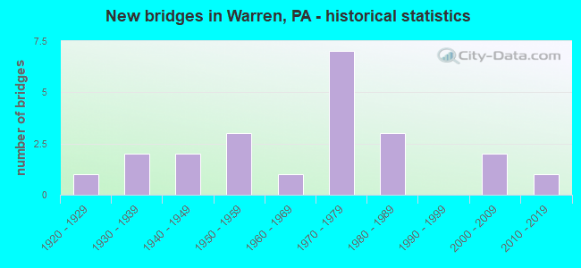
- New bridges - historical statistics
- 11920-1929
- 21930-1939
- 21940-1949
- 31950-1959
- 11960-1969
- 71970-1979
- 31980-1989
- 22000-2009
- 12010-2019

- Reconstructed bridges - Historical Statistics
- 11970-1979
- 21980-1989
- 01990-1999
- 02000-2009
- 12010-2019


- Bridge Condition - Deck
- 5.3%Excellent
- 10.5%Very good
- 10.5%Good
- 47.4%Satisfactory
- 15.8%Fair
- 10.5%Poor

- Bridge Condition - Superstructure
- 21.1%Very good
- 21.1%Good
- 15.8%Satisfactory
- 36.8%Fair
- 5.3%Poor

- Bridge Condition - Substructure
- 5.3%Very good
- 36.8%Good
- 21.1%Satisfactory
- 31.6%Fair
- 5.3%Poor

- Bridge Condition - Channel
- 6.3%Very good
- 31.3%Good
- 31.3%Satisfactory
- 25.0%Fair
- 6.3%Poor
Find on map >> Show street view
Structure Number: 33968, Location: CONEWANGO TOWNSHIP (Lat: 41.837942, Lng: -79.177706), Route carried "on" structure: US 6, Year Built: 1976, Status: Open, Structure Length: 5.67m (18.60ft), Average Daily Traffic: 9,236 (year 2021), Truck Traffic: 10%, Average Future Daily Traffic: 13,352 (year 2032), Design Load: HS 20, Features Intersected: OVER ALLEGHENY & EASTERN
Minimum Vertical Clearance: 30+ m (98+ ft), Kilometerpoint: 42.826, Lanes on structure: 4, Base Highway Network: Yes, Owner: State Highway Agency, Approaching Roadway Width: 18.3m (60.0ft), Skew: 34 degrees, Material/Design: Prestressed concrete, Design/Construction: Box Beam or Girders - Single/Spread, Number Of Spans In Main Unit: 3, Length of Maximum Span: 19.8m (65.0ft), Curb or Sidewalk Widths: Left: 0.2m (0.7ft), Right: 0.2m (0.7ft), Curb-To-Curb Width: 23.8m (78.1ft), Out-to-Out Width: 25.1m (82.3ft)
Condition: Deck: Satisfactory, Superstructure: Fair, Substructure: Fair, Operating Rating: 89.8 metric tons, Method Used To Determine Operating Rating: Load Factor (LF), Inventory Rating: 53.5 metric tons, Method Used To Determine Inventory Rating: Load Factor (LF), Structural Evaluation: Somewhat better than minimum adequacy, Deck Geometry: Superior to present desirable criteria, Underclear: High priority of corrective action, Approach Roadway Alignment: Better than present minimum criteria, Length Of Structure Improvement: 6.60m (21.65ft), Designated Inspection Frequency: Every 24 months, Inspection Date: March 2020, Bridge Improvement Cost: $79,000, Roadway Improvement Cost: $231,000, Total Project Cost: $1,061,000, Deck Structure Type: Concrete Cast-file-Place, Wearing Surface/Protective System: Wearing Surface: Bituminous, Membrane: Preformed Fabric
Find on map >> Show street view
Structure Number: 3397, Location: WARREN CITY (Lat: 41.834619, Lng: -79.168003), Route carried "on" structure: US 6, Year Built: 1976, Year Reconstructed: 1984, Status: Open, Structure Length: 5.06m (16.60ft), Average Daily Traffic: 8,022 (year 2020), Truck Traffic: 11%, Average Future Daily Traffic: 14,413 (year 2032), Design Load: HS 20, Features Intersected: OVER SR62,LUDOW ST E/W
Minimum Vertical Clearance: 30+ m (98+ ft), Kilometerpoint: 44.494, Lanes on structure: 5, Lanes under structure: 3, Base Highway Network: Yes, Owner: State Highway Agency, Approaching Roadway Width: 17.7m (58.1ft), Skew: 31 degrees, Material/Design: Prestressed concrete, Design/Construction: Stringer/Multi-beam, Number Of Spans In Main Unit: 3, Length of Maximum Span: 30.8m (101.0ft), Curb or Sidewalk Widths: Left: 0.2m (0.7ft), Right: 0.2m (0.7ft), Curb-To-Curb Width: 13.4m (44.0ft), Out-to-Out Width: 28.7m (94.2ft)
Condition: Deck: Satisfactory, Superstructure: Satisfactory, Substructure: Satisfactory, Operating Rating: 68.0 metric tons, Method Used To Determine Operating Rating: Load Factor (LF), Inventory Rating: 31.8 metric tons, Method Used To Determine Inventory Rating: Load Factor (LF), Structural Evaluation: Equal to present minimum criteria, Deck Geometry: High priority of replacement, Underclear: Equal to present minimum criteria, Approach Roadway Alignment: Equal to present desirable criteria, Length Of Structure Improvement: 5.10m (16.73ft), Designated Inspection Frequency: Every 24 months, Inspection Date: June 2021, Bridge Improvement Cost: $89,000, Roadway Improvement Cost: $263,000, Total Project Cost: $1,205,000, Deck Structure Type: Concrete Cast-file-Place, Wearing Surface/Protective System: Wearing Surface: Bituminous, Membrane: Preformed Fabric
Find on map >> Show street view
Structure Number: 33971, Location: PLEASANT TOWNSHIP (Lat: 41.836044, Lng: -79.162306), Route carried "on" structure: US 6, Year Built: 1976, Status: Open, Structure Length: 15.85m (52.00ft), Average Daily Traffic: 8,022 (year 2020), Truck Traffic: 11%, Average Future Daily Traffic: 14,413 (year 2032), Design Load: HS 20, Features Intersected: OVER ALLEGHENY RIVER
Minimum Vertical Clearance: 30+ m (98+ ft), Kilometerpoint: 44.494, Lanes on structure: 4, Base Highway Network: Yes, Owner: State Highway Agency, Approaching Roadway Width: 17.7m (58.1ft), Skew: 32 degrees, Material/Design: Prestressed concrete, Design/Construction: Box Beam or Girders - Single/Spread, Number Of Spans In Main Unit: 6, Length of Maximum Span: 26.2m (86.0ft), Curb or Sidewalk Widths: Left: 0.2m (0.7ft), Right: 0.2m (0.7ft), Curb-To-Curb Width: 11.6m (38.1ft), Out-to-Out Width: 25.0m (82.0ft)
Condition: Deck: Satisfactory, Superstructure: Satisfactory, Substructure: Satisfactory, Channel: Good, Operating Rating: 80.7 metric tons, Method Used To Determine Operating Rating: Load Factor (LF), Inventory Rating: 29.0 metric tons, Method Used To Determine Inventory Rating: Load Factor (LF), Structural Evaluation: Equal to present minimum criteria, Deck Geometry: High priority of replacement, Waterway Adequacy: Equal to present minimum criteria, Approach Roadway Alignment: Equal to present desirable criteria, Length Of Structure Improvement: 16.70m (54.79ft), Designated Inspection Frequency: Every 24 months, Underwater Inspection Frequency: Every 60 months, Inspection Date: May 2020, Underwater Inspection Date: July 2021, Bridge Improvement Cost: $177,000, Roadway Improvement Cost: $522,000, Total Project Cost: $2,393,000, Deck Structure Type: Concrete Cast-file-Place, Wearing Surface/Protective System: Wearing Surface: Bituminous, Membrane: Preformed Fabric
Find on map >> Show street view
Structure Number: 33976, Location: MEAD TOWNSHIP (Lat: 41.820011, Lng: -79.109503), Route carried "on" structure: US 6, Year Built: 1947, Status: Open, Structure Length: 0.79m (2.59ft), Average Daily Traffic: 6,949 (year 2020), Truck Traffic: 13%, Average Future Daily Traffic: 8,937 (year 2032), Design Load: HS 20, Features Intersected: OVER MORRISON RUN
Minimum Vertical Clearance: 30+ m (98+ ft), Kilometerpoint: 49.521, Lanes on structure: 2, Base Highway Network: Yes, Owner: State Highway Agency, Approaching Roadway Width: 10.7m (35.1ft), Material/Design: Concrete, Design/Construction: Tee Beam, Number Of Spans In Main Unit: 1, Length of Maximum Span: 7.3m (24.0ft), Curb-To-Curb Width: 12.2m (40.0ft), Out-to-Out Width: 13.1m (43.0ft)
Condition: Deck: Satisfactory, Superstructure: Fair, Substructure: Satisfactory, Channel: Satisfactory, Operating Rating: 62.6 metric tons, Method Used To Determine Operating Rating: Load Factor (LF), Inventory Rating: 37.2 metric tons, Method Used To Determine Inventory Rating: Load Factor (LF), Structural Evaluation: Somewhat better than minimum adequacy, Deck Geometry: Somewhat better than minimum adequacy, Waterway Adequacy: Equal to present minimum criteria, Approach Roadway Alignment: Equal to present desirable criteria, Length Of Structure Improvement: 1.40m (4.59ft), Designated Inspection Frequency: Every 24 months, Inspection Date: May 2021, Wearing Surface/Protective System: Wearing Surface: Bituminous, Membrane: Preformed Fabric
Find on map >> Show street view
Structure Number: 33978, Location: MEAD TOWNSHIP (Lat: 41.814983, Lng: -79.102311), Route carried "on" structure: US 6, Year Built: 1947, Status: Open, Structure Length: 1.37m (4.49ft), Average Daily Traffic: 6,949 (year 2020), Truck Traffic: 13%, Average Future Daily Traffic: 8,937 (year 2032), Design Load: H 20, Features Intersected: OVER DUTCHMAN RUN
Minimum Vertical Clearance: 30+ m (98+ ft), Kilometerpoint: 50.598, Lanes on structure: 2, Base Highway Network: Yes, Owner: State Highway Agency, Approaching Roadway Width: 10.4m (34.1ft), Skew: 3 degrees, Material/Design: Concrete, Design/Construction: Tee Beam, Number Of Spans In Main Unit: 1, Length of Maximum Span: 13.1m (43.0ft), Curb-To-Curb Width: 12.2m (40.0ft), Out-to-Out Width: 13.2m (43.3ft)
Condition: Deck: Fair, Superstructure: Fair, Substructure: Fair, Channel: Fair, Operating Rating: 64.4 metric tons, Method Used To Determine Operating Rating: Load Factor (LF), Inventory Rating: 36.3 metric tons, Method Used To Determine Inventory Rating: Load Factor (LF), Structural Evaluation: Somewhat better than minimum adequacy, Deck Geometry: Somewhat better than minimum adequacy, Waterway Adequacy: Equal to present minimum criteria, Approach Roadway Alignment: Equal to present desirable criteria, Length Of Structure Improvement: 2.10m (6.89ft), Designated Inspection Frequency: Every 24 months, Inspection Date: July 2021, Wearing Surface/Protective System: Wearing Surface: Bituminous, Membrane: Preformed Fabric
Find on map >> Show street view
Structure Number: 34005, Location: MEAD TOWNSHIP (Lat: 41.821769, Lng: -79.107747), Route carried "on" structure: State highway 59, Year Built: 1924, Year Reconstructed: 1987, Status: Open, Structure Length: 0.91m (2.99ft), Average Daily Traffic: 1,638 (year 2022), Truck Traffic: 12%, Average Future Daily Traffic: 2,401 (year 2032), Design Load: HS 15, Features Intersected: OVER MORRISON RUN
Minimum Vertical Clearance: 30+ m (98+ ft), Kilometerpoint: 0.000, Lanes on structure: 2, Owner: State Highway Agency, Approaching Roadway Width: 8.2m (26.9ft), Material/Design: Concrete, Design/Construction: Tee Beam, Number Of Spans In Main Unit: 1, Length of Maximum Span: 8.8m (28.9ft), Curb or Sidewalk Widths: Left: 0.2m (0.7ft), Right: 0.2m (0.7ft), Curb-To-Curb Width: 9.2m (30.2ft), Out-to-Out Width: 10.3m (33.8ft)
Condition: Deck: Poor, Superstructure: Fair, Substructure: Fair, Channel: Satisfactory, Operating Rating: 68.9 metric tons, Method Used To Determine Operating Rating: Load Factor (LF), Inventory Rating: 40.8 metric tons, Method Used To Determine Inventory Rating: Load Factor (LF), Structural Evaluation: Somewhat better than minimum adequacy, Deck Geometry: Somewhat better than minimum adequacy, Waterway Adequacy: Equal to present minimum criteria, Approach Roadway Alignment: Equal to present desirable criteria, Length Of Structure Improvement: 1.60m (5.25ft), Designated Inspection Frequency: Every 24 months, Inspection Date: Febuary 2020, Bridge Improvement Cost: $15,000, Roadway Improvement Cost: $44,000, Total Project Cost: $203,000, Wearing Surface/Protective System: Wearing Surface: Bituminous, Membrane: Preformed Fabric
Find on map >> Show street view
Structure Number: 34006, Location: MEAD TOWNSHIP (Lat: 41.821922, Lng: -79.107253), Route carried "on" structure: State highway 59, Year Built: 1931, Year Reconstructed: 1987, Status: Open, Structure Length: 1.01m (3.31ft), Average Daily Traffic: 1,638 (year 2022), Truck Traffic: 12%, Average Future Daily Traffic: 2,401 (year 2032), Design Load: HS 15, Features Intersected: OVER BROWN RUN
Minimum Vertical Clearance: 30+ m (98+ ft), Kilometerpoint: 0.689, Lanes on structure: 2, Owner: State Highway Agency, Approaching Roadway Width: 8.5m (27.9ft), Material/Design: Concrete, Design/Construction: Tee Beam, Number Of Spans In Main Unit: 1, Length of Maximum Span: 9.4m (30.8ft), Curb or Sidewalk Widths: Left: 0.2m (0.7ft), Right: 0.2m (0.7ft), Curb-To-Curb Width: 9.3m (30.5ft), Out-to-Out Width: 10.1m (33.1ft)
Condition: Deck: Satisfactory, Superstructure: Fair, Substructure: Fair, Channel: Fair, Operating Rating: 54.4 metric tons, Method Used To Determine Operating Rating: Load Factor (LF), Inventory Rating: 32.7 metric tons, Method Used To Determine Inventory Rating: Load Factor (LF), Structural Evaluation: Somewhat better than minimum adequacy, Deck Geometry: Somewhat better than minimum adequacy, Waterway Adequacy: Equal to present minimum criteria, Approach Roadway Alignment: Equal to present desirable criteria, Length Of Structure Improvement: 1.60m (5.25ft), Designated Inspection Frequency: Every 24 months, Inspection Date: Febuary 2020, Bridge Improvement Cost: $5,000, Roadway Improvement Cost: $15,000, Total Project Cost: $70,000, Wearing Surface/Protective System: Wearing Surface: Bituminous, Membrane: Preformed Fabric
Find on map >> Show street view
Structure Number: 34104, Location: GLADE TOWNSHIP (Lat: 41.849414, Lng: -79.057964), Route carried "on" structure: State highway , Year Built: 1952, Status: Open, Structure Length: 1.65m (5.41ft), Average Daily Traffic: 241 (year 2020), Truck Traffic: 7%, Average Future Daily Traffic: 285 (year 2032), Design Load: H 20, Features Intersected: OVER HEMLOCK RUN, Facility Carried by Structure: SR 1006,HEMLOCK RD
Minimum Vertical Clearance: 30+ m (98+ ft), Kilometerpoint: 5.536, Lanes on structure: 2, Owner: State Highway Agency, Approaching Roadway Width: 4.6m (15.1ft), Skew: 4 degrees, Material/Design: Steel, Design/Construction: Stringer/Multi-beam, Number Of Spans In Main Unit: 1, Length of Maximum Span: 15.8m (51.8ft), Curb or Sidewalk Widths: Left: 0.1m (0.3ft), Right: 0.1m (0.3ft), Curb-To-Curb Width: 6.7m (22.0ft), Out-to-Out Width: 7.6m (24.9ft)
Condition: Deck: Fair, Superstructure: Fair, Substructure: Fair, Channel: Good, Operating Rating: 46.3 metric tons, Method Used To Determine Operating Rating: Load Factor (LF), Inventory Rating: 27.2 metric tons, Method Used To Determine Inventory Rating: Load Factor (LF), Structural Evaluation: Somewhat better than minimum adequacy, Deck Geometry: Meets minimum limits, Waterway Adequacy: Better than present minimum criteria, Approach Roadway Alignment: Equal to present desirable criteria, Length Of Structure Improvement: 2.30m (7.55ft), Designated Inspection Frequency: Every 24 months, Inspection Date: April 2020, Bridge Improvement Cost: $3,000, Roadway Improvement Cost: $8,000, Total Project Cost: $38,000, Deck Structure Type: Closed Grating, Wearing Surface/Protective System: Wearing Surface: Bituminous
Find on map >> Show street view
Structure Number: 34121, Location: GLADE TOWNSHIP (Lat: 41.836478, Lng: -79.117586), Route carried "on" structure: State highway , Year Built: 1959, Status: Open, Structure Length: 1.01m (3.31ft), Average Daily Traffic: 989 (year 2021), Truck Traffic: 8%, Average Future Daily Traffic: 1,709 (year 2032), Design Load: HS 20, Features Intersected: OVER GLADE RUN, Facility Carried by Structure: SR 1013,COBHAM PK.
Minimum Vertical Clearance: 30+ m (98+ ft), Kilometerpoint: 0.349, Lanes on structure: 2, Owner: State Highway Agency, Approaching Roadway Width: 5.5m (18.0ft), Skew: 1 degrees, Material/Design: Prestressed concrete, Design/Construction: Box Beam or Girders - Multiple, Number Of Spans In Main Unit: 1, Length of Maximum Span: 9.4m (30.8ft), Curb or Sidewalk Widths: Left: 0.2m (0.7ft), Right: 0.2m (0.7ft), Curb-To-Curb Width: 9.1m (29.9ft), Out-to-Out Width: 10.7m (35.1ft)
Condition: Deck: Fair, Superstructure: Fair, Substructure: Poor, Channel: Poor, Operating Rating: 49.0 metric tons, Method Used To Determine Operating Rating: Load Factor (LF), Inventory Rating: 32.7 metric tons, Method Used To Determine Inventory Rating: Load Factor (LF), Structural Evaluation: Meets minimum limits, Deck Geometry: Equal to present minimum criteria, Waterway Adequacy: Superior to present desirable criteria, Approach Roadway Alignment: Equal to present desirable criteria, Length Of Structure Improvement: 1.60m (5.25ft), Designated Inspection Frequency: Every 24 months, Other Special Inspection Frequency: Every 6 months, Inspection Date: July 2021, Other Special Inspection Date: July 2021, Deck Structure Type: Other, Wearing Surface/Protective System: Wearing Surface: Bituminous
Find on map >> Show street view
Structure Number: 34122, Location: GLADE TOWNSHIP (Lat: 41.846325, Lng: -79.102517), Route carried "on" structure: State highway , Year Built: 1958, Status: Open, Structure Length: 1.04m (3.41ft), Average Daily Traffic: 989 (year 2021), Truck Traffic: 8%, Average Future Daily Traffic: 1,709 (year 2032), Design Load: HS 20, Features Intersected: OVER GLADE RUN, Facility Carried by Structure: SR 1013,COBHAM PK.
Minimum Vertical Clearance: 30+ m (98+ ft), Kilometerpoint: 2.219, Lanes on structure: 2, Owner: State Highway Agency, Approaching Roadway Width: 7.3m (24.0ft), Skew: 4 degrees, Material/Design: Prestressed concrete, Design/Construction: Box Beam or Girders - Multiple, Number Of Spans In Main Unit: 1, Length of Maximum Span: 9.8m (32.2ft), Curb or Sidewalk Widths: Left: 0.2m (0.7ft), Right: 0.2m (0.7ft), Curb-To-Curb Width: 9.1m (29.9ft), Out-to-Out Width: 10.7m (35.1ft)
Condition: Deck: Poor, Superstructure: Poor, Substructure: Fair, Channel: Good, Operating Rating: 56.2 metric tons, Method Used To Determine Operating Rating: Load Factor (LF), Inventory Rating: 31.8 metric tons, Method Used To Determine Inventory Rating: Load Factor (LF), Structural Evaluation: Meets minimum limits, Deck Geometry: Equal to present minimum criteria, Waterway Adequacy: Equal to present desirable criteria, Approach Roadway Alignment: Equal to present desirable criteria, Length Of Structure Improvement: 1.70m (5.58ft), Designated Inspection Frequency: Every 24 months, Inspection Date: July 2021, Deck Structure Type: Other, Wearing Surface/Protective System: Wearing Surface: Bituminous, Membrane: Preformed Fabric
Find on map >> Show street view
Structure Number: 3413, Location: GLADE TOWNSHIP (Lat: 41.857764, Lng: -79.098831), Route carried "on" structure: State highway , Year Built: 1964, Status: Open, Structure Length: 0.79m (2.59ft), Average Daily Traffic: 69 (year 2020), Truck Traffic: 7%, Average Future Daily Traffic: 92 (year 2032), Design Load: H 20, Features Intersected: OVER PAGE HALLOW RUN, Facility Carried by Structure: SR 1025,PGE HOLLOW
Minimum Vertical Clearance: 30+ m (98+ ft), Kilometerpoint: 0.832, Lanes on structure: 2, Owner: State Highway Agency, Approaching Roadway Width: 5.2m (17.1ft), Skew: 4 degrees, Material/Design: Concrete, Design/Construction: Slab, Number Of Spans In Main Unit: 1, Length of Maximum Span: 7.3m (24.0ft), Curb or Sidewalk Widths: Left: 0.5m (1.6ft), Right: 0.5m (1.6ft), Curb-To-Curb Width: 9.1m (29.9ft), Out-to-Out Width: 10.8m (35.4ft)
Condition: Deck: Very good, Superstructure: Very good, Substructure: Good, Channel: Fair, Operating Rating: 49.9 metric tons, Method Used To Determine Operating Rating: Allowable Stress (AS), Inventory Rating: 29.9 metric tons, Method Used To Determine Inventory Rating: Allowable Stress (AS), Structural Evaluation: Better than present minimum criteria, Deck Geometry: Better than present minimum criteria, Waterway Adequacy: Better than present minimum criteria, Approach Roadway Alignment: Equal to present desirable criteria, Length Of Structure Improvement: 1.40m (4.59ft), Designated Inspection Frequency: Every 24 months, Inspection Date: July 2021, Wearing Surface/Protective System: Wearing Surface: Bituminous, Membrane: Preformed Fabric
Find on map >> Show street view
Structure Number: 34131, Location: WARREN CITY (Lat: 41.837494, Lng: -79.153178), Route carried "on" structure: State highway , Year Built: 1976, Status: Open, Structure Length: 3.90m (12.80ft), Average Daily Traffic: 3,642 (year 2021), Truck Traffic: 6%, Average Future Daily Traffic: 2,725 (year 2032), Design Load: HS 20, Features Intersected: OVER SR 6 EB/WB,DORCON, Facility Carried by Structure: SR 1027,MAIN AVE.
Minimum Vertical Clearance: 30+ m (98+ ft), Kilometerpoint: 0.000, Lanes on structure: 5, Lanes under structure: 8, Owner: State Highway Agency, Approaching Roadway Width: 19.5m (64.0ft), Skew: 30 degrees, Material/Design: Steel, Design/Construction: Stringer/Multi-beam, Number Of Spans In Main Unit: 1, Length of Maximum Span: 38.1m (125.0ft), Curb or Sidewalk Widths: Left: 0.2m (0.7ft), Right: 0.2m (0.7ft), Curb-To-Curb Width: 25.7m (84.3ft), Out-to-Out Width: 26.8m (87.9ft)
Condition: Deck: Satisfactory, Superstructure: Satisfactory, Substructure: Satisfactory, Operating Rating: 98.0 metric tons, Method Used To Determine Operating Rating: Load Factor (LF), Inventory Rating: 59.0 metric tons, Method Used To Determine Inventory Rating: Load Factor (LF), Structural Evaluation: Equal to present minimum criteria, Deck Geometry: Superior to present desirable criteria, Underclear: Equal to present minimum criteria, Approach Roadway Alignment: Equal to present desirable criteria, Length Of Structure Improvement: 4.00m (13.12ft), Designated Inspection Frequency: Every 24 months, Inspection Date: June 2021, Bridge Improvement Cost: $12,000, Roadway Improvement Cost: $34,000, Total Project Cost: $157,000, Deck Structure Type: Concrete Cast-file-Place, Wearing Surface/Protective System: Wearing Surface: Bituminous, Deck Protection: Epoxy Coated Reinforcing
Find on map >> Show street view
Structure Number: 34224, Location: CITY OF WARREN (Lat: 41.843444, Lng: -79.139742), Route carried "on" structure: US 6B, Year Built: 1987, Status: Open, Structure Length: 6.07m (19.91ft), Average Daily Traffic: 9,417 (year 2021), Truck Traffic: 7%, Average Future Daily Traffic: 12,540 (year 2032), Design Load: HS 25 or greater, Features Intersected: OVER CONEWANGO CREEK, Facility Carried by Structure: SR 6006,PENN AVE.E
Minimum Vertical Clearance: 30+ m (98+ ft), Kilometerpoint: 0.000, Lanes on structure: 3, Base Highway Network: Yes, Owner: State Highway Agency, Approaching Roadway Width: 12.8m (42.0ft), Material/Design: Prestressed concrete continuous, Design/Construction: Stringer/Multi-beam, Number Of Spans In Main Unit: 2, Length of Maximum Span: 29.3m (96.1ft), Curb or Sidewalk Widths: Left: 1.9m (6.2ft), Right: 1.9m (6.2ft), Curb-To-Curb Width: 12.8m (42.0ft), Out-to-Out Width: 17.1m (56.1ft)
Condition: Deck: Good, Superstructure: Good, Substructure: Good, Channel: Satisfactory, Operating Rating: 39.9 metric tons, Method Used To Determine Operating Rating: Load and Resistance Factor (LRFR), Inventory Rating: 30.8 metric tons, Method Used To Determine Inventory Rating: Load and Resistance Factor (LRFR), Structural Evaluation: Better than present minimum criteria, Deck Geometry: Meets minimum limits, Waterway Adequacy: Equal to present minimum criteria, Approach Roadway Alignment: Equal to present desirable criteria, Length Of Structure Improvement: 7.10m (23.29ft), Designated Inspection Frequency: Every 24 months, Underwater Inspection Frequency: Every 24 months, Inspection Date: June 2020, Underwater Inspection Date: July 2021, Deck Structure Type: Concrete Cast-file-Place, Wearing Surface/Protective System: Wearing Surface: Bituminous, Membrane: Preformed Fabric, Deck Protection: Epoxy Coated Reinforcing
Find on map >> Show street view
Structure Number: 34225, Location: CITY OF WARREN (Lat: 41.828308, Lng: -79.121500), Route carried "on" structure: US 6B, Year Built: 1931, Year Reconstructed: 2015, Status: Open, Structure Length: 0.98m (3.22ft), Average Daily Traffic: 8,056 (year 2021), Truck Traffic: 11%, Average Future Daily Traffic: 10,374 (year 2032), Design Load: HL 93, Features Intersected: OVER GLADE RUN, Facility Carried by Structure: SR 6006,PENN AVE.E
Minimum Vertical Clearance: 30+ m (98+ ft), Kilometerpoint: 2.739, Lanes on structure: 2, Base Highway Network: Yes, Owner: State Highway Agency, Approaching Roadway Width: 11.9m (39.0ft), Material/Design: Prestressed concrete, Design/Construction: Box Beam or Girders - Single/Spread, Number Of Spans In Main Unit: 1, Length of Maximum Span: 9.1m (29.9ft), Curb or Sidewalk Widths: Left: 1.7m (5.6ft), Right: 1.7m (5.6ft), Curb-To-Curb Width: 12.2m (40.0ft), Out-to-Out Width: 16.2m (53.1ft)
Condition: Deck: Excellent, Superstructure: Very good, Substructure: Good, Channel: Good, Operating Rating: 42.1 metric tons, Method Used To Determine Operating Rating: Assigned ratings based on Load and Resistance Factor Design (LRFD) reported by rating factor (RF) using HL93 loadings, Inventory Rating: 32.4 metric tons, Method Used To Determine Inventory Rating: Assigned ratings based on Load and Resistance Factor Design (LRFD) reported by rating factor (RF) using HL93 loadings, Structural Evaluation: Better than present minimum criteria, Deck Geometry: Somewhat better than minimum adequacy, Waterway Adequacy: Equal to present minimum criteria, Approach Roadway Alignment: Equal to present desirable criteria, Length Of Structure Improvement: 1.60m (5.25ft), Designated Inspection Frequency: Every 48 months, Inspection Date: September 2019, Bridge Improvement Cost: $11,000, Roadway Improvement Cost: $33,000, Total Project Cost: $150,000, Wearing Surface/Protective System: Wearing Surface: Bituminous, Membrane: Preformed Fabric
Find on map >> Show street view
Structure Number: 34226, Location: MEAD TOWNSHIP (Lat: 41.824483, Lng: -79.119011), Route carried "on" structure: US 6B, Year Built: 1987, Status: Open, Structure Length: 17.16m (56.30ft), Average Daily Traffic: 8,056 (year 2021), Truck Traffic: 11%, Average Future Daily Traffic: 10,374 (year 2032), Design Load: HS 25 or greater, Features Intersected: OVER ALLEGHENY RIVER, Facility Carried by Structure: SR 6006,GLADE BRG.
Minimum Vertical Clearance: 30+ m (98+ ft), Kilometerpoint: 3.111, Lanes on structure: 2, Base Highway Network: Yes, Owner: State Highway Agency, Approaching Roadway Width: 10.4m (34.1ft), Material/Design: Steel continuous, Design/Construction: Stringer/Multi-beam, Number Of Spans In Main Unit: 4, Length of Maximum Span: 48.5m (159.1ft), Curb or Sidewalk Widths: Left: 1.2m (3.9ft), Right: 0.2m (0.7ft), Curb-To-Curb Width: 10.7m (35.1ft), Out-to-Out Width: 13.3m (43.6ft)
Condition: Deck: Satisfactory, Superstructure: Good, Substructure: Good, Channel: Satisfactory, Operating Rating: 46.3 metric tons, Method Used To Determine Operating Rating: Load Factor (LF), Inventory Rating: 27.2 metric tons, Method Used To Determine Inventory Rating: Load Factor (LF), Structural Evaluation: Equal to present minimum criteria, Deck Geometry: Meets minimum limits, Waterway Adequacy: Superior to present desirable criteria, Approach Roadway Alignment: Better than present minimum criteria, Length Of Structure Improvement: 17.90m (58.73ft), Designated Inspection Frequency: Every 24 months, Underwater Inspection Frequency: Every 60 months, Inspection Date: July 2020, Underwater Inspection Date: July 2021, Deck Structure Type: Concrete Cast-file-Place, Wearing Surface/Protective System: Wearing Surface: Bituminous, Membrane: Preformed Fabric, Deck Protection: Epoxy Coated Reinforcing
Find on map >> Show street view
Structure Number: 34297, Location: CITY OF WARREN (Lat: 41.847386, Lng: -79.140747), Route carried "on" structure: City street 7405, Year Built: 1983, Status: Open, Structure Length: 12.95m (42.49ft), Average Daily Traffic: 4,000 (year 2013), Truck Traffic: 8%, Average Future Daily Traffic: 5,360 (year 2023), Design Load: HS 20, Features Intersected: CONEWANGO CREEK, Facility Carried by Structure: 3RD AVENUE
Minimum Vertical Clearance: 30+ m (98+ ft), Kilometerpoint: 0.000, Lanes on structure: 2, Owner: City or Municipal Highway Agency, Approaching Roadway Width: 8.5m (27.9ft), Material/Design: Prestressed concrete, Design/Construction: Box Beam or Girders - Multiple, Number Of Spans In Main Unit: 5, Length of Maximum Span: 25.9m (85.0ft), Curb or Sidewalk Widths: Left: 0.2m (0.7ft), Right: 2.4m (7.9ft), Curb-To-Curb Width: 8.5m (27.9ft), Out-to-Out Width: 12.3m (40.4ft)
Condition: Deck: Satisfactory, Superstructure: Good, Substructure: Good, Channel: Fair, Operating Rating: 67.1 metric tons, Method Used To Determine Operating Rating: Load Factor (LF), Inventory Rating: 40.8 metric tons, Method Used To Determine Inventory Rating: Load Factor (LF), Structural Evaluation: Better than present minimum criteria, Deck Geometry: Meets minimum limits, Waterway Adequacy: Better than present minimum criteria, Approach Roadway Alignment: Equal to present desirable criteria, Length Of Structure Improvement: 13.90m (45.60ft), Designated Inspection Frequency: Every 24 months, Inspection Date: July 2021, Deck Structure Type: Concrete Cast-file-Place, Wearing Surface/Protective System: Wearing Surface: Monolithic Concrete, Deck Protection: Epoxy Coated Reinforcing
Find on map >> Show street view
Structure Number: 42871, Location: CITY OF WARREN (Lat: 41.844050, Lng: -79.149778), Route carried "on" structure: City street , Year Built: 2005, Status: Open, Structure Length: 15.91m (52.20ft), Average Daily Traffic: 1,455 (year 2013), Truck Traffic: 5%, Average Future Daily Traffic: 1,890 (year 2033), Design Load: HL 93, Features Intersected: ALLEGHENY RIVER, Facility Carried by Structure: SR 3005 HICKORY ST
Minimum Vertical Clearance: 30+ m (98+ ft), Kilometerpoint: 0.000, Lanes on structure: 3, Owner: City or Municipal Highway Agency, Approaching Roadway Width: 20.1m (65.9ft), Skew: 1 degrees, Material/Design: Prestressed concrete continuous, Design/Construction: Box Beam or Girders - Multiple, Number Of Spans In Main Unit: 4, Length of Maximum Span: 39.0m (128.0ft), Curb or Sidewalk Widths: Left: 2.1m (6.9ft), Right: 2.1m (6.9ft), Curb-To-Curb Width: 13.1m (43.0ft), Out-to-Out Width: 19.1m (62.7ft)
Condition: Deck: Satisfactory, Superstructure: Very good, Substructure: Good, Channel: Good, Operating Rating: 87.1 metric tons, Method Used To Determine Operating Rating: Load Factor (LF), Inventory Rating: 57.2 metric tons, Method Used To Determine Inventory Rating: Load Factor (LF), Structural Evaluation: Better than present minimum criteria, Deck Geometry: Meets minimum limits, Waterway Adequacy: Superior to present desirable criteria, Approach Roadway Alignment: Better than present minimum criteria, Length Of Structure Improvement: 16.60m (54.46ft), Designated Inspection Frequency: Every 24 months, Underwater Inspection Frequency: Every 60 months, Inspection Date: July 2021, Underwater Inspection Date: October 2017, Deck Structure Type: Concrete Cast-file-Place, Wearing Surface/Protective System: Wearing Surface: Monolithic Concrete, Deck Protection: Epoxy Coated Reinforcing
Find on map >> Show street view
Structure Number: 44258, Location: CITY OF WARREN (Lat: 41.850428, Lng: -79.141850), Route carried "on" structure: City street , Year Built: 2006, Status: Open, Structure Length: 10.85m (35.60ft), Average Daily Traffic: 2,000 (year 2013), Truck Traffic: 5%, Average Future Daily Traffic: 2,500 (year 2033), Design Load: HL 93, Features Intersected: CONEWANGO CREEK, Facility Carried by Structure: 5TH AVENUE
Minimum Vertical Clearance: 30+ m (98+ ft), Kilometerpoint: 0.000, Lanes on structure: 2, Owner: City or Municipal Highway Agency, Approaching Roadway Width: 8.5m (27.9ft), Material/Design: Prestressed concrete continuous, Design/Construction: Box Beam or Girders - Multiple, Number Of Spans In Main Unit: 3, Length of Maximum Span: 35.4m (116.1ft), Curb or Sidewalk Widths: Left: 0.2m (0.7ft), Right: 1.5m (4.9ft), Curb-To-Curb Width: 8.5m (27.9ft), Out-to-Out Width: 11.4m (37.4ft)
Condition: Deck: Good, Superstructure: Good, Substructure: Good, Channel: Satisfactory, Operating Rating: 67.1 metric tons, Method Used To Determine Operating Rating: Load and Resistance Factor (LRFR), Inventory Rating: 43.5 metric tons, Method Used To Determine Inventory Rating: Load and Resistance Factor (LRFR), Structural Evaluation: Better than present minimum criteria, Deck Geometry: Somewhat better than minimum adequacy, Waterway Adequacy: Superior to present desirable criteria, Approach Roadway Alignment: Equal to present desirable criteria, Designated Inspection Frequency: Every 24 months, Inspection Date: July 2021, Deck Structure Type: Concrete Cast-file-Place, Wearing Surface/Protective System: Wearing Surface: Monolithic Concrete, Deck Protection: Epoxy Coated Reinforcing
Find on map >> Show street view
Structure Number: 57265, Location: MEAD TOWNSHIP (Lat: 41.818481, Lng: -79.092972), Route carried "on" structure: State highway , Year Built: 2019, Status: Open, Structure Length: 1.95m (6.40ft), Average Daily Traffic: 208 (year 2021), Truck Traffic: 6%, Average Future Daily Traffic: 458 (year 2032), Design Load: HL 93, Features Intersected: OVER BROWNS RUN, Facility Carried by Structure: SR 2010,BROWN RN R
Minimum Vertical Clearance: 30+ m (98+ ft), Kilometerpoint: 0.793, Lanes on structure: 1, Owner: State Highway Agency, Approaching Roadway Width: 4.9m (16.1ft), Skew: 4 degrees, Material/Design: Prestressed concrete, Design/Construction: Box Beam or Girders - Single/Spread, Number Of Spans In Main Unit: 1, Length of Maximum Span: 18.3m (60.0ft), Curb-To-Curb Width: 4.9m (16.1ft), Out-to-Out Width: 5.9m (19.4ft)
Condition: Deck: Very good, Superstructure: Very good, Substructure: Very good, Channel: Very good, Operating Rating: 52.2 metric tons, Method Used To Determine Operating Rating: Assigned ratings based on Load and Resistance Factor Design (LRFD) reported by rating factor (RF) using HL93 loadings, Inventory Rating: 36.3 metric tons, Method Used To Determine Inventory Rating: Assigned ratings based on Load and Resistance Factor Design (LRFD) reported by rating factor (RF) using HL93 loadings, Structural Evaluation: Equal to present desirable criteria, Deck Geometry: High priority of replacement, Waterway Adequacy: Equal to present desirable criteria, Approach Roadway Alignment: Equal to present desirable criteria, Designated Inspection Frequency: Every 48 months, Inspection Date: November 2021, Deck Structure Type: Concrete Cast-file-Place, Wearing Surface/Protective System: Wearing Surface: Epoxy Overlay, Membrane: Epoxy, Deck Protection: Epoxy Coated Reinforcing
Find on map >> Show street view
Structure Number: 3397, Location: WARREN CITY (Lat: 41.834619, Lng: -79.168003), Route carried "under" structure: US 62, Year Built: 1976, Structure Length: 0. m, Average Daily Traffic: 4,581 (year 2021), Truck Traffic: 10%, Features Intersected: OVER SR62,LUDOW ST E/W, Facility Carried by Structure: SR 6,WARREN BYPASS
Minimum Vertical Clearance: 4.62m (15.16ft), Kilometerpoint: 31.794, Lanes on structure: 5, Lanes under structure: 3, Material/Design: Prestressed concrete, Design/Construction: Stringer/Multi-beam, Length of Maximum Span: 30.8m (101.0ft)
Find on map >> Show street view
Structure Number: 34131, Location: WARREN CITY (Lat: 41.837494, Lng: -79.153178), Route carried "under" structure: US 6, Year Built: 1976, Structure Length: 0. m, Average Daily Traffic: 2,664 (year 2022), Truck Traffic: 15%, Features Intersected: OVER SR 6 EB/WB,DORCON, Facility Carried by Structure: SR 1027,MAIN AVE.
Minimum Vertical Clearance: 5.18m (16.99ft), Kilometerpoint: 45.190, Lanes on structure: 5, Lanes under structure: 4, Material/Design: Steel, Design/Construction: Stringer/Multi-beam, Length of Maximum Span: 38.1m (125.0ft)
Find on map >> Show street view
Structure Number: 34131, Location: WARREN CITY (Lat: 41.837494, Lng: -79.153178), Route carried "under" structure: US 6, Year Built: 1976, Structure Length: 0. m, Average Daily Traffic: 1,805 (year 2022), Truck Traffic: 18%, Features Intersected: OVER SR 6 EB/WB,DORCON, Facility Carried by Structure: SR 1027,MAIN AVE.
Minimum Vertical Clearance: 4.82m (15.81ft), Kilometerpoint: 45.189, Lanes on structure: 5, Lanes under structure: 4, Material/Design: Steel, Design/Construction: Stringer/Multi-beam, Length of Maximum Span: 38.1m (125.0ft)