Bridge Statistics for Vista, California (CA)
Condition, Traffic, Stress, Structural Evaluation, Project Costs
- National Bridge Inventory (NBI) Statistics
- 21Number of bridges
- 282ft / 86.4mTotal length
- $11,760,000Total costs
- 1,558,472Total average daily traffic
- 68,864Total average daily truck traffic
- National Bridge Inventory (NBI) Registered Bridges for Vista
- No street view available for this location
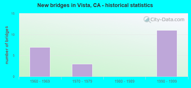
- New bridges - historical statistics
- 71960-1969
- 31970-1979
- 111990-1999

- Reconstructed bridges - Historical Statistics
- 21980-1989
- 11990-1999


- Bridge Condition - Deck
- 18.2%Good
- 72.7%Fair
- 9.1%Poor

- Bridge Condition - Substructure
- 90.9%Good
- 9.1%Fair

- Bridge Condition - Channel
- 11.1%Excellent
- 55.6%Very good
- 22.2%Satisfactory
- 11.1%Fair

- Bridge Condition - Culverts
- 66.7%Good
- 33.3%Fair
Find on map >> Show street view
Structure Number: 57 0391, Location: 11-SD-005-R16.02-SD (Lat: 32.724375, Lng: -117.154686), Route carried "on" structure: Interstate 5, Year Built: 1961, Year Reconstructed: 1985, Status: Open, Structure Length: 13.72m (45.01ft), Average Daily Traffic: 199,000 (year 2020), Truck Traffic: 4%, Average Future Daily Traffic: 278,209 (year 2040), Design Load: HS 20, Features Intersected: RTE 163, CONNECTORS
Minimum Vertical Clearance: 30+ m (98+ ft), Kilometerpoint: 16.020, Lanes on structure: 11, Lanes under structure: 8, Base Highway Network: Yes (, Subroute: 1), Owner: State Highway Agency, Approaching Roadway Width: 49.4m (162.1ft), Skew: 30 degrees, Material/Design: Concrete continuous, Design/Construction: Box Beam or Girders - Multiple, Number Of Spans In Main Unit: 6, Length of Maximum Span: 45.7m (149.9ft), Curb-To-Curb Width: 49.6m (162.7ft), Out-to-Out Width: 51.2m (168.0ft)
Condition: Deck: Poor, Superstructure: Good, Substructure: Good, Operating Rating: 54.1 metric tons, Method Used To Determine Operating Rating: Assigned rating based on Load Factor Design (LFD) reported in metric tons, Inventory Rating: 32.4 metric tons, Method Used To Determine Inventory Rating: Assigned rating based on Load Factor Design (LFD) reported in metric tons, Structural Evaluation: Better than present minimum criteria, Deck Geometry: Superior to present desirable criteria, Underclear: High priority of corrective action, Approach Roadway Alignment: Equal to present desirable criteria, Length Of Structure Improvement: 13.72m (45.01ft), Designated Inspection Frequency: Every 24 months, Inspection Date: August 2021, Bridge Improvement Cost: $7,000,000, Roadway Improvement Cost: $1,400,000, Total Project Cost: $11,760,000 ( Estimate for 2020), Deck Structure Type: Concrete Cast-file-Place
Find on map >> Show street view
Structure Number: 57 0398, Location: 11-SD-078-5.94-VSTA (Lat: 33.194658, Lng: -117.254119), Route carried "on" structure: State highway 78, Year Built: 1994, Status: Open, Structure Length: 4.55m (14.93ft), Average Daily Traffic: 142,000 (year 2012), Truck Traffic: 5%, Average Future Daily Traffic: 194,205 (year 2040), Design Load: HS 20+Mod, Features Intersected: MELROSE DR
Minimum Vertical Clearance: 30+ m (98+ ft), Kilometerpoint: 5.940, Lanes on structure: 6, Lanes under structure: 8, Base Highway Network: Yes (, Subroute: 1), Owner: State Highway Agency, Approaching Roadway Width: 34.7m (113.8ft), Skew: 31 degrees, Material/Design: Prestressed concrete continuous, Design/Construction: Stringer/Multi-beam, Number Of Spans In Main Unit: 2, Length of Maximum Span: 22.7m (74.5ft), Curb-To-Curb Width: 34.7m (113.8ft), Out-to-Out Width: 35.7m (117.1ft)
Condition: Deck: Fair, Superstructure: Good, Substructure: Good, Operating Rating: 54.1 metric tons, Method Used To Determine Operating Rating: Assigned rating based on Load Factor Design (LFD) reported in metric tons, Inventory Rating: 32.4 metric tons, Method Used To Determine Inventory Rating: Assigned rating based on Load Factor Design (LFD) reported in metric tons, Structural Evaluation: Better than present minimum criteria, Deck Geometry: Superior to present desirable criteria, Underclear: High priority of corrective action, Approach Roadway Alignment: Superior to present desirable criteria, Designated Inspection Frequency: Every 24 months, Inspection Date: April 2021, Deck Structure Type: Concrete Cast-file-Place
Find on map >> Show street view
Structure Number: 57 04, Location: 11-SD-078-6.94-VSTA (Lat: 33.189453, Lng: -117.239328), Route carried "on" structure: City street S372, Year Built: 1962, Year Reconstructed: 1996, Status: Open, Structure Length: 8.29m (27.20ft), Average Daily Traffic: 28,100 (year 2012), Truck Traffic: 1%, Average Future Daily Traffic: 41,908 (year 2040), Design Load: HS 20, Features Intersected: STATE ROUTE 78, Facility Carried by Structure: CIVIC CENTER DRIVE
Minimum Vertical Clearance: 5.58m (18.31ft), Kilometerpoint: 0.000, Lanes on structure: 5, Lanes under structure: 7, Owner: State Highway Agency, Approaching Roadway Width: 25.9m (85.0ft), Material/Design: Concrete continuous, Design/Construction: Box Beam or Girders - Multiple, Number Of Spans In Main Unit: 5, Length of Maximum Span: 19.2m (63.0ft), Curb or Sidewalk Widths: Left: 1.5m (4.9ft), Right: 1.5m (4.9ft), Curb-To-Curb Width: 23.8m (78.1ft), Out-to-Out Width: 26.3m (86.3ft)
Condition: Deck: Good, Superstructure: Good, Substructure: Good, Operating Rating: 45.0 metric tons, Method Used To Determine Operating Rating: Load and Resistance Factor Rating (LRFR) rating reported by rating factor(RF) method using HL-93 loadings, Inventory Rating: 34.7 metric tons, Method Used To Determine Inventory Rating: Load and Resistance Factor Rating (LRFR) rating reported by rating factor(RF) method using HL-93 loadings, Structural Evaluation: Better than present minimum criteria, Deck Geometry: Better than present minimum criteria, Underclear: Meets minimum limits, Approach Roadway Alignment: Equal to present desirable criteria, Designated Inspection Frequency: Every 48 months, Inspection Date: April 2021, Deck Structure Type: Concrete Cast-file-Place
Find on map >> Show street view
Structure Number: 57 0402, Location: 11-SD-078-9.08-VSTA (Lat: 33.167036, Lng: -117.214642), Route carried "on" structure: State highway 78, Year Built: 1994, Status: Open, Structure Length: 4.94m (16.21ft), Average Daily Traffic: 154,000 (year 2012), Truck Traffic: 5%, Average Future Daily Traffic: 218,607 (year 2040), Design Load: HS 20+Mod, Features Intersected: SYCAMORE AVE
Minimum Vertical Clearance: 30+ m (98+ ft), Kilometerpoint: 9.080, Lanes on structure: 6, Lanes under structure: 8, Base Highway Network: Yes (, Subroute: 1), Owner: State Highway Agency, Approaching Roadway Width: 11.1m (36.4ft), Skew: 31 degrees, Material/Design: Prestressed concrete, Design/Construction: Stringer/Multi-beam, Number Of Spans In Main Unit: 2, Length of Maximum Span: 25.6m (84.0ft), Curb-To-Curb Width: 34.5m (113.2ft), Out-to-Out Width: 35.8m (117.5ft)
Condition: Deck: Good, Superstructure: Good, Substructure: Good, Operating Rating: 54.1 metric tons, Method Used To Determine Operating Rating: Assigned rating based on Load Factor Design (LFD) reported in metric tons, Inventory Rating: 32.4 metric tons, Method Used To Determine Inventory Rating: Assigned rating based on Load Factor Design (LFD) reported in metric tons, Structural Evaluation: Better than present minimum criteria, Deck Geometry: Superior to present desirable criteria, Underclear: High priority of corrective action, Approach Roadway Alignment: Equal to present desirable criteria, Designated Inspection Frequency: Every 24 months, Inspection Date: April 2021, Deck Structure Type: Concrete Cast-file-Place
Find on map >> Show street view
Structure Number: 57 0515, Location: 11-SD-078-6.15-VSTA (Lat: 33.195019, Lng: -117.250794), Route carried "on" structure: State highway 78, Year Built: 1962, Status: Open, Structure Length: 1.86m (6.10ft), Average Daily Traffic: 150,000 (year 2012), Truck Traffic: 5%, Average Future Daily Traffic: 218,607 (year 2040), Features Intersected: BUENA VISTA CREEK
Minimum Vertical Clearance: 30+ m (98+ ft), Kilometerpoint: 6.150, Lanes on structure: 6, Base Highway Network: Yes (, Subroute: 1), Owner: State Highway Agency, Approaching Roadway Width: 10.4m (34.1ft), Skew: 32 degrees, Material/Design: Concrete, Design/Construction: Culvert, Number Of Spans In Main Unit: 5, Length of Maximum Span: 3.0m (9.8ft), Curb-To-Curb Width: 33.9m (111.2ft), Out-to-Out Width: 33.9m (111.2ft)
Condition: Channel: Very good, Culverts: Fair, Operating Rating: 54.1 metric tons, Method Used To Determine Operating Rating: Field evaluation and documented engineering judgment, Inventory Rating: 32.4 metric tons, Method Used To Determine Inventory Rating: Field evaluation and documented engineering judgment, Structural Evaluation: Somewhat better than minimum adequacy, Deck Geometry: Superior to present desirable criteria, Waterway Adequacy: Equal to present desirable criteria, Approach Roadway Alignment: Equal to present desirable criteria, Length Of Structure Improvement: 1.86m (6.10ft), Designated Inspection Frequency: Every 24 months, Inspection Date: April 2021
Find on map >> Show street view
Structure Number: 57 0515K, Location: 11-SD-078-6.14-VSTA (Lat: 33.195397, Lng: -117.250536), Route carried "on" structure: Ramp State highway 78, Year Built: 1998, Status: Open, Structure Length: 7.71m (25.30ft), Average Daily Traffic: 8,600 (year 2012), Truck Traffic: 2%, Average Future Daily Traffic: 14,038 (year 2040), Design Load: HS 20+Mod, Features Intersected: BUENA VISTA CREEK
Minimum Vertical Clearance: 30+ m (98+ ft), Kilometerpoint: 6.140, Lanes on structure: 2, Base Highway Network: Yes, Owner: State Highway Agency, Approaching Roadway Width: 11.0m (36.1ft), Material/Design: Concrete continuous, Design/Construction: Box Beam or Girders - Multiple, Number Of Spans In Main Unit: 3, Length of Maximum Span: 30.8m (101.0ft), Curb-To-Curb Width: 11.0m (36.1ft), Out-to-Out Width: 12.0m (39.4ft)
Condition: Deck: Fair, Superstructure: Good, Substructure: Good, Channel: Very good, Operating Rating: 54.1 metric tons, Method Used To Determine Operating Rating: Assigned rating based on Load Factor Design (LFD) reported in metric tons, Inventory Rating: 32.4 metric tons, Method Used To Determine Inventory Rating: Assigned rating based on Load Factor Design (LFD) reported in metric tons, Structural Evaluation: Better than present minimum criteria, Deck Geometry: Better than present minimum criteria, Waterway Adequacy: Superior to present desirable criteria, Approach Roadway Alignment: Equal to present desirable criteria, Designated Inspection Frequency: Every 24 months, Inspection Date: April 2021, Deck Structure Type: Concrete Cast-file-Place
Find on map >> Show street view
Structure Number: 57 0515S, Location: 11-SD-078-6.12-VSTA (Lat: 33.194589, Lng: -117.251533), Route carried "on" structure: Ramp State highway 78, Year Built: 1998, Status: Open, Structure Length: 7.07m (23.20ft), Average Daily Traffic: 7,500 (year 2012), Truck Traffic: 1%, Average Future Daily Traffic: 13,096 (year 2040), Design Load: HS 20+Mod, Features Intersected: BUENA VISTA CREEK
Minimum Vertical Clearance: 30+ m (98+ ft), Kilometerpoint: 6.120, Lanes on structure: 2, Base Highway Network: Yes, Owner: State Highway Agency, Approaching Roadway Width: 11.0m (36.1ft), Skew: 1 degrees, Material/Design: Concrete continuous, Design/Construction: Box Beam or Girders - Multiple, Number Of Spans In Main Unit: 3, Length of Maximum Span: 22.7m (74.5ft), Curb or Sidewalk Widths: Left: 1.2m (3.9ft), Right: 2.4m (7.9ft), Curb-To-Curb Width: 11.0m (36.1ft), Out-to-Out Width: 12.0m (39.4ft)
Condition: Deck: Fair, Superstructure: Good, Substructure: Fair, Channel: Excellent, Operating Rating: 54.1 metric tons, Method Used To Determine Operating Rating: Assigned rating based on Load Factor Design (LFD) reported in metric tons, Inventory Rating: 32.4 metric tons, Method Used To Determine Inventory Rating: Assigned rating based on Load Factor Design (LFD) reported in metric tons, Structural Evaluation: Somewhat better than minimum adequacy, Deck Geometry: Better than present minimum criteria, Waterway Adequacy: Superior to present desirable criteria, Approach Roadway Alignment: Equal to present desirable criteria, Designated Inspection Frequency: Every 24 months, Inspection Date: April 2021, Deck Structure Type: Concrete Cast-file-Place
Find on map >> Show street view
Structure Number: 57 0516, Location: 11-SD-078-9.07-VSTA (Lat: 33.167325, Lng: -117.214975), Route carried "on" structure: State highway 78, Year Built: 1962, Status: Open, Structure Length: 1.04m (3.41ft), Average Daily Traffic: 154,000 (year 2011), Truck Traffic: 5%, Average Future Daily Traffic: 218,608 (year 2038), Design Load: HS 20, Features Intersected: BUENA CREEK
Minimum Vertical Clearance: 30+ m (98+ ft), Kilometerpoint: 9.070, Lanes on structure: 10, Base Highway Network: Yes (, Subroute: 1), Owner: State Highway Agency, Approaching Roadway Width: 47.0m (154.2ft), Skew: 21 degrees, Material/Design: Concrete, Design/Construction: Culvert, Number Of Spans In Main Unit: 3, Length of Maximum Span: 3.0m (9.8ft), Curb-To-Curb Width: 47.0m (154.2ft), Out-to-Out Width: 47.0m (154.2ft)
Condition: Channel: Very good, Culverts: Good, Operating Rating: 54.1 metric tons, Method Used To Determine Operating Rating: Field evaluation and documented engineering judgment, Inventory Rating: 32.4 metric tons, Method Used To Determine Inventory Rating: Field evaluation and documented engineering judgment, Structural Evaluation: Better than present minimum criteria, Deck Geometry: Superior to present desirable criteria, Waterway Adequacy: Equal to present desirable criteria, Approach Roadway Alignment: Equal to present desirable criteria, Length Of Structure Improvement: 1.04m (3.41ft), Designated Inspection Frequency: Every 48 months, Inspection Date: April 2019
Find on map >> Show street view
Structure Number: 57 0768, Location: 11-SD-078-4.38-VSTA (Lat: 33.187953, Lng: -117.279572), Route carried "on" structure: City street S367, Year Built: 1971, Year Reconstructed: 1992, Status: Open, Structure Length: 6.22m (20.41ft), Average Daily Traffic: 13,500 (year 2012), Truck Traffic: 1%, Average Future Daily Traffic: 26,193 (year 2040), Design Load: HS 20+Mod, Features Intersected: STATE ROUTE 78, Facility Carried by Structure: EMERALD DR
Minimum Vertical Clearance: 5.72m (18.77ft), Kilometerpoint: 0.000, Lanes on structure: 7, Lanes under structure: 6, Owner: State Highway Agency, Approaching Roadway Width: 32.9m (107.9ft), Skew: 3 degrees, Material/Design: Prestressed concrete continuous, Design/Construction: Box Beam or Girders - Multiple, Number Of Spans In Main Unit: 2, Length of Maximum Span: 31.4m (103.0ft), Curb or Sidewalk Widths: Left: 1.5m (4.9ft), Right: 1.5m (4.9ft), Curb-To-Curb Width: 31.1m (102.0ft), Out-to-Out Width: 34.7m (113.8ft)
Condition: Deck: Fair, Superstructure: Good, Substructure: Good, Operating Rating: 54.1 metric tons, Method Used To Determine Operating Rating: Assigned rating based on Load Factor Design (LFD) reported in metric tons, Inventory Rating: 32.4 metric tons, Method Used To Determine Inventory Rating: Assigned rating based on Load Factor Design (LFD) reported in metric tons, Structural Evaluation: Better than present minimum criteria, Deck Geometry: Better than present minimum criteria, Underclear: High priority of corrective action, Approach Roadway Alignment: Superior to present desirable criteria, Designated Inspection Frequency: Every 24 months, Inspection Date: April 2021, Deck Structure Type: Concrete Cast-file-Place
Find on map >> Show street view
Structure Number: 57C0514, Location: 45FT E/O MIMOSA AVE (Lat: 33.156300, Lng: -117.214861), Route carried "on" structure: City street , Year Built: 1978, Status: Open, Structure Length: 1.71m (5.61ft), Average Daily Traffic: 10,072 (year 2016), Truck Traffic: 1%, Average Future Daily Traffic: 11,312 (year 2038), Design Load: HS 20, Features Intersected: AQUA HEDIONDA CREEK, Facility Carried by Structure: OLEANDER AVE
Minimum Vertical Clearance: 30+ m (98+ ft), Kilometerpoint: 0.000, Lanes on structure: 2, Owner: County Highway Agency, Approaching Roadway Width: 13.1m (43.0ft), Skew: 2 degrees, Material/Design: Concrete, Design/Construction: Culvert, Number Of Spans In Main Unit: 4, Length of Maximum Span: 3.7m (12.1ft), Curb-To-Curb Width: 9.1m (29.9ft), Out-to-Out Width: 9.8m (32.2ft)
Condition: Channel: Satisfactory, Culverts: Good, Operating Rating: 54.1 metric tons, Method Used To Determine Operating Rating: Field evaluation and documented engineering judgment, Inventory Rating: 32.4 metric tons, Method Used To Determine Inventory Rating: Field evaluation and documented engineering judgment, Structural Evaluation: Better than present minimum criteria, Deck Geometry: High priority of corrective action, Waterway Adequacy: Somewhat better than minimum adequacy, Approach Roadway Alignment: Equal to present desirable criteria, Designated Inspection Frequency: Every 48 months, Inspection Date: May 2019
Find on map >> Show street view
Structure Number: 57C0702, Location: AT LADO DE LOMA DRIVE (Lat: 33.196792, Lng: -117.248581), Route carried "on" structure: City street , Year Built: 1995, Status: Open, Structure Length: 3.29m (10.79ft), Average Daily Traffic: 39,000 (year 2016), Truck Traffic: 2%, Average Future Daily Traffic: 43,000 (year 2038), Design Load: HS 20+Mod, Features Intersected: BUENA VISTA CREEK CHAN, Facility Carried by Structure: VISTA VILLAGE DR
Minimum Vertical Clearance: 30+ m (98+ ft), Kilometerpoint: 0.000, Lanes on structure: 7, Owner: City or Municipal Highway Agency, Approaching Roadway Width: 31.1m (102.0ft), Skew: 24 degrees, Material/Design: Prestressed concrete, Design/Construction: Box Beam or Girders - Multiple, Number Of Spans In Main Unit: 1, Length of Maximum Span: 31.7m (104.0ft), Curb or Sidewalk Widths: Left: 2.4m (7.9ft), Right: 2.4m (7.9ft), Curb-To-Curb Width: 31.1m (102.0ft), Out-to-Out Width: 54.6m (179.1ft)
Condition: Deck: Fair, Superstructure: Good, Substructure: Good, Channel: Satisfactory, Operating Rating: 54.1 metric tons, Method Used To Determine Operating Rating: Assigned rating based on Load Factor Design (LFD) reported in metric tons, Inventory Rating: 32.4 metric tons, Method Used To Determine Inventory Rating: Assigned rating based on Load Factor Design (LFD) reported in metric tons, Structural Evaluation: Better than present minimum criteria, Deck Geometry: Better than present minimum criteria, Waterway Adequacy: Equal to present desirable criteria, Approach Roadway Alignment: Equal to present desirable criteria, Designated Inspection Frequency: Every 24 months, Inspection Date: Febuary 2021, Deck Structure Type: Concrete Cast-file-Place
Find on map >> Show street view
Structure Number: 57C0703, Location: 0.4 MI E/O EMERALD DRIVE (Lat: 33.188383, Lng: -117.273625), Route carried "on" structure: City street , Year Built: 1993, Status: Open, Structure Length: 8.99m (29.49ft), Average Daily Traffic: 20,250 (year 2016), Truck Traffic: 1%, Average Future Daily Traffic: 29,488 (year 2038), Features Intersected: BUENA VISTA CREEK CHAN, Facility Carried by Structure: HACIENDA DRIVE
Minimum Vertical Clearance: 30+ m (98+ ft), Kilometerpoint: 0.000, Lanes on structure: 2, Owner: City or Municipal Highway Agency, Approaching Roadway Width: 15.8m (51.8ft), Skew: 35 degrees, Material/Design: Prestressed concrete continuous, Design/Construction: Box Beam or Girders - Multiple, Number Of Spans In Main Unit: 3, Length of Maximum Span: 30.5m (100.1ft), Curb or Sidewalk Widths: Left: 1.5m (4.9ft), Right: 1.5m (4.9ft), Curb-To-Curb Width: 15.8m (51.8ft), Out-to-Out Width: 19.5m (64.0ft)
Condition: Deck: Fair, Superstructure: Good, Substructure: Good, Channel: Fair, Operating Rating: 54.1 metric tons, Method Used To Determine Operating Rating: Field evaluation and documented engineering judgment, Inventory Rating: 32.4 metric tons, Method Used To Determine Inventory Rating: Field evaluation and documented engineering judgment, Structural Evaluation: Better than present minimum criteria, Deck Geometry: Superior to present desirable criteria, Waterway Adequacy: Equal to present desirable criteria, Approach Roadway Alignment: Equal to present desirable criteria, Designated Inspection Frequency: Every 24 months, Inspection Date: Febuary 2021, Deck Structure Type: Concrete Cast-file-Place
Find on map >> Show street view
Structure Number: 57C0704L, Location: 0.5 MI S/O SHADOWRIDGE DR (Lat: 33.153983, Lng: -117.241928), Route carried "on" structure: City street , Year Built: 1990, Status: Open, Structure Length: 8.50m (27.89ft), Average Daily Traffic: 15,600 (year 2016), Truck Traffic: 1%, Average Future Daily Traffic: 16,969 (year 2038), Features Intersected: AGUA HEDIONDA CREEK, Facility Carried by Structure: SOUTH MELROSE DR
Minimum Vertical Clearance: 30+ m (98+ ft), Kilometerpoint: 0.000, Lanes on structure: 3, Base Highway Network: Yes, Owner: City or Municipal Highway Agency, Approaching Roadway Width: 13.4m (44.0ft), Skew: 1 degrees, Material/Design: Prestressed concrete continuous, Design/Construction: Box Beam or Girders - Multiple, Number Of Spans In Main Unit: 3, Length of Maximum Span: 33.8m (110.9ft), Curb or Sidewalk Widths: Left: 1.5m (4.9ft), Right: 0.0m, Curb-To-Curb Width: 13.4m (44.0ft), Out-to-Out Width: 15.8m (51.8ft)
Condition: Deck: Fair, Superstructure: Good, Substructure: Good, Channel: Very good, Operating Rating: 28.2 metric tons, Method Used To Determine Operating Rating: Load and Resistance Factor Rating (LRFR) rating reported by rating factor(RF) method using HL-93 loadings, Inventory Rating: 14.6 metric tons, Method Used To Determine Inventory Rating: Load and Resistance Factor Rating (LRFR) rating reported by rating factor(RF) method using HL-93 loadings, Structural Evaluation: High priority of corrective action, Deck Geometry: Somewhat better than minimum adequacy, Waterway Adequacy: Equal to present desirable criteria, Approach Roadway Alignment: Equal to present desirable criteria, Designated Inspection Frequency: Every 24 months, Inspection Date: Febuary 2021, Deck Structure Type: Concrete Cast-file-Place
Find on map >> Show street view
Structure Number: 57C0704R, Location: 0.5 MI S/O SHADOWRIDGE DR (Lat: 33.153997, Lng: -117.241708), Route carried "on" structure: City street , Year Built: 1990, Status: Open, Structure Length: 8.50m (27.89ft), Average Daily Traffic: 15,600 (year 2016), Truck Traffic: 1%, Average Future Daily Traffic: 16,969 (year 2038), Features Intersected: AGUA HEDIONDA CREEK, Facility Carried by Structure: SOUTH MELROSE DR
Minimum Vertical Clearance: 30+ m (98+ ft), Kilometerpoint: 0.000, Lanes on structure: 3, Base Highway Network: Yes, Owner: City or Municipal Highway Agency, Approaching Roadway Width: 13.4m (44.0ft), Skew: 1 degrees, Material/Design: Prestressed concrete continuous, Design/Construction: Box Beam or Girders - Multiple, Number Of Spans In Main Unit: 3, Length of Maximum Span: 33.8m (110.9ft), Curb or Sidewalk Widths: Left: 0.0m, Right: 1.5m (4.9ft), Curb-To-Curb Width: 13.4m (44.0ft), Out-to-Out Width: 15.8m (51.8ft)
Condition: Deck: Fair, Superstructure: Good, Substructure: Good, Channel: Very good, Operating Rating: 28.2 metric tons, Method Used To Determine Operating Rating: Load and Resistance Factor Rating (LRFR) rating reported by rating factor(RF) method using HL-93 loadings, Inventory Rating: 14.6 metric tons, Method Used To Determine Inventory Rating: Load and Resistance Factor Rating (LRFR) rating reported by rating factor(RF) method using HL-93 loadings, Structural Evaluation: High priority of corrective action, Deck Geometry: Somewhat better than minimum adequacy, Waterway Adequacy: Equal to present desirable criteria, Approach Roadway Alignment: Equal to present desirable criteria, Designated Inspection Frequency: Every 24 months, Inspection Date: Febuary 2021, Deck Structure Type: Concrete Cast-file-Place
Find on map >> Show street view
Structure Number: 57 0398, Location: 11-SD-078-5.94-VSTA (Lat: 33.194658, Lng: -117.254119), Route carried "under" structure: City street S368, Year Built: 1994, Structure Length: 0. m, Average Daily Traffic: 25,050 (year 2012), Truck Traffic: 6%, Features Intersected: MELROSE DR, Facility Carried by Structure: STATE ROUTE 78
Minimum Vertical Clearance: 4.88m (16.01ft), Kilometerpoint: 0.000, Lanes on structure: 6, Lanes under structure: 8, Material/Design: Prestressed concrete continuous, Design/Construction: Stringer/Multi-beam, Length of Maximum Span: 22.7m (74.5ft)
Find on map >> Show street view
Structure Number: 57 04, Location: 11-SD-078-6.94-VSTA (Lat: 33.189453, Lng: -117.239328), Route carried "under" structure: Ramp State highway 78, Year Built: 1962, Structure Length: 0. m, Average Daily Traffic: 9,100 (year 2012), Truck Traffic: 3%, Features Intersected: STATE ROUTE 78, Facility Carried by Structure: CIVIC CENTER DRIVE
Minimum Vertical Clearance: 7.59m (24.90ft), Kilometerpoint: 6.940, Lanes on structure: 5, Lanes under structure: 1, Material/Design: Concrete continuous, Design/Construction: Box Beam or Girders - Multiple, Length of Maximum Span: 19.2m (63.0ft)
Find on map >> Show street view
Structure Number: 57 04, Location: 11-SD-078-6.94-VSTA (Lat: 33.189453, Lng: -117.239328), Route carried "under" structure: State highway 78, Year Built: 1962, Structure Length: 0. m, Average Daily Traffic: 130,000 (year 2012), Truck Traffic: 5%, Features Intersected: STATE ROUTE 78, Facility Carried by Structure: CIVIC CENTER DRIVE
Minimum Vertical Clearance: 4.72m (15.49ft), Kilometerpoint: 6.940, Lanes on structure: 5, Lanes under structure: 6, Material/Design: Concrete continuous, Design/Construction: Box Beam or Girders - Multiple, Length of Maximum Span: 19.2m (63.0ft)
Find on map >> Show street view
Structure Number: 57 0401, Location: 11-SD-078-7.71-VSTA (Lat: 33.181247, Lng: -117.229953), Route carried "under" structure: State highway 78, Year Built: 1962, Structure Length: 0. m, Average Daily Traffic: 128,000 (year 2012), Truck Traffic: 5%, Features Intersected: STATE ROUTE 78, Facility Carried by Structure: MAR VISTA DRIVE
Minimum Vertical Clearance: 4.62m (15.16ft), Kilometerpoint: 7.710, Lanes on structure: 2, Lanes under structure: 7, Material/Design: Concrete continuous, Design/Construction: Box Beam or Girders - Multiple, Length of Maximum Span: 30.2m (99.1ft)
Find on map >> Show street view
Structure Number: 57 0402, Location: 11-SD-078-9.08-VSTA (Lat: 33.167036, Lng: -117.214642), Route carried "under" structure: City street , Year Built: 1994, Structure Length: 0. m, Average Daily Traffic: 32,100 (year 2012), Truck Traffic: 1%, Features Intersected: SYCAMORE AVE, Facility Carried by Structure: STATE ROUTE 78
Minimum Vertical Clearance: 4.52m (14.83ft), Kilometerpoint: 9.080, Lanes on structure: 6, Lanes under structure: 8, Material/Design: Prestressed concrete, Design/Construction: Stringer/Multi-beam, Length of Maximum Span: 25.6m (84.0ft)
Find on map >> Show street view
Structure Number: 57 0768, Location: 11-SD-078-4.38-VSTA (Lat: 33.187953, Lng: -117.279572), Route carried "under" structure: State highway 78, Year Built: 1971, Structure Length: 0. m, Average Daily Traffic: 127,000 (year 2012), Truck Traffic: 5%, Features Intersected: STATE ROUTE 78, Facility Carried by Structure: EMERALD DR
Minimum Vertical Clearance: 5.00m (16.40ft), Kilometerpoint: 4.380, Lanes on structure: 7, Lanes under structure: 6, Material/Design: Prestressed concrete continuous, Design/Construction: Box Beam or Girders - Multiple, Length of Maximum Span: 31.4m (103.0ft)
Find on map >> Show street view
Structure Number: 57 103, Location: 11-SD-078-6.19-VSTA (Lat: 33.194847, Lng: -117.250089), Route carried "under" structure: State highway 78, Year Built: 1998, Structure Length: 0. m, Average Daily Traffic: 150,000 (year 2012), Truck Traffic: 5%, Features Intersected: STATE ROUTE 78, Facility Carried by Structure: VISTA VILLAGE DR
Minimum Vertical Clearance: 5.66m (18.57ft), Kilometerpoint: 6.190, Lanes on structure: 7, Lanes under structure: 6, Material/Design: Concrete continuous, Design/Construction: Box Beam or Girders - Multiple, Length of Maximum Span: 36.0m (118.1ft)