Bridge Statistics for Vinings, Georgia (GA)
Condition, Traffic, Stress, Structural Evaluation, Project Costs
- National Bridge Inventory (NBI) Statistics
- 53Number of bridges
- 991ft / 302mTotal length
- $620,975,000Total costs
- 2,839,312Total average daily traffic
- 58,905Total average daily truck traffic
- National Bridge Inventory (NBI) Registered Bridges for Vinings
- No street view available for this location
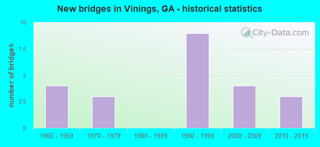
- New bridges - historical statistics
- 41960-1969
- 31970-1979
- 91990-1999
- 42000-2009
- 32010-2019

- Reconstructed bridges - Historical Statistics
- 11970-1979
- 21980-1989
- 11990-1999
- 02000-2009
- 12010-2019


- Bridge Condition - Superstructure
- 36.4%Very good
- 63.6%Good

- Bridge Condition - Substructure
- 9.1%Very good
- 90.9%Good

- Bridge Condition - Channel
- 85.7%Very good
- 14.3%Good
Find on map >> Show street view
Structure Number: 670066, Location: 6.7 MI SE OF MARIETTA (Lat: 33.889706, Lng: -84.460350), Route carried "on" structure: Interstate 75, Year Built: 1963, Year Reconstructed: 2018, Status: Open, Structure Length: 5.18m (16.99ft), Average Daily Traffic: 141,050 (year 2012), Truck Traffic: 5%, Average Future Daily Traffic: 211,575 (year 2032), Design Load: HS 20+Mod, Features Intersected: I-285 RAMP CBL CD
Minimum Vertical Clearance: 30+ m (98+ ft), Kilometerpoint: 416.820, Lanes on structure: 8, Lanes under structure: 4, Base Highway Network: Yes, Owner: State Highway Agency, Approaching Roadway Width: 47.5m (155.8ft), Skew: 30 degrees, Material/Design: Steel continuous, Design/Construction: Stringer/Multi-beam, Number Of Spans In Main Unit: 3, Length of Maximum Span: 23.8m (78.1ft), Curb-To-Curb Width: 48.2m (158.1ft), Out-to-Out Width: 54.6m (179.1ft)
Condition: Deck: Good, Superstructure: Good, Substructure: Good, Operating Rating: 54.4 metric tons, Method Used To Determine Operating Rating: Load Factor (LF), Inventory Rating: 32.6 metric tons, Method Used To Determine Inventory Rating: Load Factor (LF), Structural Evaluation: Better than present minimum criteria, Deck Geometry: Superior to present desirable criteria, Underclear: Somewhat better than minimum adequacy, Approach Roadway Alignment: Equal to present desirable criteria, Designated Inspection Frequency: Every 24 months, Inspection Date: June 2021, Bridge Improvement Cost: $1,751,000, Roadway Improvement Cost: $175,000, Total Project Cost: $2,627,000, Deck Structure Type: Concrete Cast-file-Place
Find on map >> Show street view
Structure Number: 670088, Location: 6.7 MI SE OF MARIETTA (Lat: 33.888528, Lng: -84.462519), Route carried "on" structure: Ramp Interstate 285, Year Built: 1963, Year Reconstructed: 1997, Status: Open, Structure Length: 4.18m (13.71ft), Average Daily Traffic: 16,020 (year 2012), Truck Traffic: 1%, Average Future Daily Traffic: 24,030 (year 2032), Design Load: HS 20+Mod, Features Intersected: I-285 CBL CD
Minimum Vertical Clearance: 30+ m (98+ ft), Kilometerpoint: 32.187, Lanes on structure: 2, Lanes under structure: 3, Base Highway Network: Yes, Owner: State Highway Agency, Approaching Roadway Width: 12.2m (40.0ft), Material/Design: Steel, Design/Construction: Stringer/Multi-beam, Number Of Spans In Main Unit: 3, Length of Maximum Span: 18.3m (60.0ft), Curb-To-Curb Width: 13.5m (44.3ft), Out-to-Out Width: 14.5m (47.6ft)
Condition: Deck: Good, Superstructure: Good, Substructure: Good, Operating Rating: 34.4 metric tons, Method Used To Determine Operating Rating: Load Factor (LF), Inventory Rating: 20.8 metric tons, Method Used To Determine Inventory Rating: Load Factor (LF), Structural Evaluation: Somewhat better than minimum adequacy, Deck Geometry: Superior to present desirable criteria, Underclear: Somewhat better than minimum adequacy, Approach Roadway Alignment: Equal to present desirable criteria, Designated Inspection Frequency: Every 24 months, Inspection Date: March 2021, Deck Structure Type: Concrete Cast-file-Place
Find on map >> Show street view
Structure Number: 670097, Location: 3.7 MI SE OF SMYRNA (Lat: 33.839369, Lng: -84.487142), Route carried "on" structure: Interstate 285, Year Built: 1968, Year Reconstructed: 1983, Status: Open, Structure Length: 4.08m (13.39ft), Average Daily Traffic: 140,510 (year 2012), Truck Traffic: 1%, Average Future Daily Traffic: 210,765 (year 2032), Design Load: HS 20+Mod, Features Intersected: CSX RAILROAD (639140W)
Minimum Vertical Clearance: 30+ m (98+ ft), Kilometerpoint: 25.750, Lanes on structure: 10, Base Highway Network: Yes, Owner: State Highway Agency, Approaching Roadway Width: 41.8m (137.1ft), Skew: 32 degrees, Material/Design: Steel, Design/Construction: Stringer/Multi-beam, Number Of Spans In Main Unit: 1, Length of Maximum Span: 40.8m (133.9ft), Curb or Sidewalk Widths: Left: 0.2m (0.7ft), Right: 0.2m (0.7ft), Curb-To-Curb Width: 39.9m (130.9ft), Out-to-Out Width: 40.9m (134.2ft)
Condition: Deck: Good, Superstructure: Good, Substructure: Good, Operating Rating: 89.8 metric tons, Method Used To Determine Operating Rating: Load Factor (LF), Inventory Rating: 57.1 metric tons, Method Used To Determine Inventory Rating: Load Factor (LF), Structural Evaluation: Better than present minimum criteria, Deck Geometry: Meets minimum limits, Underclear: Meets minimum limits, Approach Roadway Alignment: Equal to present desirable criteria, Designated Inspection Frequency: Every 24 months, Inspection Date: March 2021, Deck Structure Type: Concrete Cast-file-Place
Find on map >> Show street view
Structure Number: 670103, Location: 6.7 MILES SOUTH EAST OF M (Lat: 33.891117, Lng: -84.459042), Route carried "on" structure: Interstate 285, Year Built: 1978, Status: Open, Structure Length: 10.06m (33.01ft), Average Daily Traffic: 79,670 (year 2012), Truck Traffic: 1%, Average Future Daily Traffic: 119,505 (year 2032), Design Load: HS 20+Mod, Features Intersected: RAMP I-285C TO I-75 NBL
Minimum Vertical Clearance: 30+ m (98+ ft), Kilometerpoint: 32.187, Lanes on structure: 5, Lanes under structure: 2, Base Highway Network: Yes, Owner: State Highway Agency, Approaching Roadway Width: 33.2m (108.9ft), Skew: 34 degrees, Material/Design: Steel continuous, Design/Construction: Stringer/Multi-beam, Number Of Spans In Main Unit: 3, Number Of Approach Spans: 2, Length of Maximum Span: 63.1m (207.0ft), Curb-To-Curb Width: 32.8m (107.6ft), Out-to-Out Width: 34.7m (113.8ft)
Condition: Deck: Good, Superstructure: Good, Substructure: Good, Operating Rating: 59.8 metric tons, Method Used To Determine Operating Rating: Load Factor (LF), Inventory Rating: 35.3 metric tons, Method Used To Determine Inventory Rating: Load Factor (LF), Structural Evaluation: Better than present minimum criteria, Deck Geometry: Superior to present desirable criteria, Underclear: Superior to present desirable criteria, Approach Roadway Alignment: Equal to present desirable criteria, Designated Inspection Frequency: Every 24 months, Inspection Date: June 2021, Bridge Improvement Cost: $2,344,000, Roadway Improvement Cost: $234,000, Total Project Cost: $3,516,000, Deck Structure Type: Concrete Cast-file-Place, Wearing Surface/Protective System: Wearing Surface: Epoxy Overlay
Find on map >> Show street view
Structure Number: 670106, Location: 6.7 MI SE OF MARIETTA (Lat: 33.892061, Lng: -84.456739), Route carried "on" structure: Interstate 285, Year Built: 1978, Year Reconstructed: 1986, Status: Open, Structure Length: 9.14m (29.99ft), Average Daily Traffic: 79,670 (year 2012), Truck Traffic: 1%, Average Future Daily Traffic: 119,505 (year 2032), Design Load: HS 20+Mod, Features Intersected: ROTTENWOOD CR-CUMB. BLVD
Minimum Vertical Clearance: 30+ m (98+ ft), Kilometerpoint: 32.187, Lanes on structure: 8, Lanes under structure: 4, Base Highway Network: Yes, Owner: State Highway Agency, Approaching Roadway Width: 41.5m (136.2ft), Skew: 30 degrees, Material/Design: Steel continuous, Design/Construction: Stringer/Multi-beam, Number Of Spans In Main Unit: 3, Length of Maximum Span: 35.4m (116.1ft), Curb-To-Curb Width: 43.1m (141.4ft), Out-to-Out Width: 45.0m (147.6ft)
Condition: Deck: Good, Superstructure: Good, Substructure: Good, Channel: Very good, Operating Rating: 46.2 metric tons, Method Used To Determine Operating Rating: Load Factor (LF), Inventory Rating: 27.2 metric tons, Method Used To Determine Inventory Rating: Load Factor (LF), Structural Evaluation: Equal to present minimum criteria, Deck Geometry: Superior to present desirable criteria, Underclear: Meets minimum limits, Waterway Adequacy: Superior to present desirable criteria, Approach Roadway Alignment: Equal to present desirable criteria, Designated Inspection Frequency: Every 24 months, Inspection Date: May 2021, Bridge Improvement Cost: $3,090,000, Roadway Improvement Cost: $309,000, Total Project Cost: $4,635,000, Deck Structure Type: Concrete Cast-file-Place, Wearing Surface/Protective System: Wearing Surface: Epoxy Overlay
Find on map >> Show street view
Structure Number: 675092, Location: 3.2 MI E OF SMYRNA (Lat: 33.878658, Lng: -84.471850), Route carried "on" structure: County highway 1965, Year Built: 1974, Year Reconstructed: 1988, Status: Open, Structure Length: 3.20m (10.50ft), Average Daily Traffic: 12,690 (year 2012), Truck Traffic: 1%, Average Future Daily Traffic: 19,035 (year 2032), Design Load: HS 20, Features Intersected: CSX RAILROAD (340371X), Facility Carried by Structure: CUMBERLAND PWY
Minimum Vertical Clearance: 30+ m (98+ ft), Kilometerpoint: 1.609, Lanes on structure: 6, Base Highway Network: Yes, Owner: County Highway Agency, Approaching Roadway Width: 22.9m (75.1ft), Material/Design: Steel, Design/Construction: Stringer/Multi-beam, Number Of Spans In Main Unit: 1, Length of Maximum Span: 32.0m (105.0ft), Curb or Sidewalk Widths: Left: 1.2m (3.9ft), Right: 1.2m (3.9ft), Curb-To-Curb Width: 23.3m (76.4ft), Out-to-Out Width: 26.5m (86.9ft)
Condition: Deck: Good, Superstructure: Good, Substructure: Good, Operating Rating: 46.2 metric tons, Method Used To Determine Operating Rating: Allowable Stress (AS), Inventory Rating: 31.7 metric tons, Method Used To Determine Inventory Rating: Allowable Stress (AS), Structural Evaluation: Better than present minimum criteria, Deck Geometry: Meets minimum limits, Underclear: Equal to present desirable criteria, Approach Roadway Alignment: Equal to present desirable criteria, Designated Inspection Frequency: Every 24 months, Inspection Date: August 2021, Bridge Improvement Cost: $858,000, Roadway Improvement Cost: $86,000, Total Project Cost: $1,287,000, Deck Structure Type: Concrete Cast-file-Place, Wearing Surface/Protective System: Wearing Surface: Bituminous
Find on map >> Show street view
Structure Number: 675094, Location: 4 MILES SOUTH EAST OF SMY (Lat: 33.870428, Lng: -84.457728), Route carried "on" structure: County highway 2019, Year Built: 1961, Status: Open, Structure Length: 0.64m (2.10ft), Average Daily Traffic: 1,930 (year 2012), Truck Traffic: 1%, Average Future Daily Traffic: 2,895 (year 2032), Design Load: H 15, Features Intersected: CHATTAHOOCHEE RIV TRIB., Facility Carried by Structure: PACES MILL ROAD
Minimum Vertical Clearance: 30+ m (98+ ft), Kilometerpoint: 0.000, Lanes on structure: 2, Base Highway Network: Yes, Owner: County Highway Agency, Approaching Roadway Width: 7.3m (24.0ft), Material/Design: Steel, Design/Construction: Culvert, Number Of Spans In Main Unit: 1, Length of Maximum Span: 6.4m (21.0ft), Curb or Sidewalk Widths: Left: 1.6m (5.2ft), Right: 0.0m
Condition: Channel: Very good, Culverts: Satisfactory, Operating Rating: 43.5 metric tons, Method Used To Determine Operating Rating: Field evaluation and documented engineering judgment, Inventory Rating: 24.4 metric tons, Method Used To Determine Inventory Rating: Field evaluation and documented engineering judgment, Structural Evaluation: Equal to present minimum criteria, Waterway Adequacy: Superior to present desirable criteria, Approach Roadway Alignment: Equal to present desirable criteria, Designated Inspection Frequency: Every 24 months, Inspection Date: August 2021, Bridge Improvement Cost: $82,000, Roadway Improvement Cost: $8,000, Total Project Cost: $123,000
Find on map >> Show street view
Structure Number: 675184, Location: 3.8 MI. SE OF SMYRNA (Lat: 33.872631, Lng: -84.476147), Route carried "on" structure: County highway 7069, Year Built: 1998, Status: Open, Structure Length: 12.56m (41.21ft), Average Daily Traffic: 1,930 (year 2012), Truck Traffic: 1%, Average Future Daily Traffic: 2,895 (year 2032), Design Load: HS 20+Mod, Features Intersected: I-285, Facility Carried by Structure: MOUNT WILKINSON PA
Minimum Vertical Clearance: 30+ m (98+ ft), Kilometerpoint: 0.000, Lanes on structure: 4, Lanes under structure: 8, Base Highway Network: Yes, Owner: State Highway Agency, Approaching Roadway Width: 17.1m (56.1ft), Skew: 21 degrees, Material/Design: Prestressed concrete, Design/Construction: Stringer/Multi-beam, Number Of Spans In Main Unit: 4, Length of Maximum Span: 36.6m (120.1ft), Curb or Sidewalk Widths: Left: 1.8m (5.9ft), Right: 1.8m (5.9ft), Curb-To-Curb Width: 21.9m (71.9ft), Out-to-Out Width: 26.3m (86.3ft)
Condition: Deck: Good, Superstructure: Very good, Substructure: Good, Operating Rating: 46.2 metric tons, Method Used To Determine Operating Rating: Allowable Stress (AS), Inventory Rating: 32.6 metric tons, Method Used To Determine Inventory Rating: Allowable Stress (AS), Structural Evaluation: Better than present minimum criteria, Deck Geometry: Superior to present desirable criteria, Underclear: Meets minimum limits, Approach Roadway Alignment: Equal to present desirable criteria, Designated Inspection Frequency: Every 24 months, Inspection Date: September 2021, Bridge Improvement Cost: $2,488,000, Roadway Improvement Cost: $249,000, Total Project Cost: $3,732,000, Deck Structure Type: Concrete Cast-file-Place
Find on map >> Show street view
Structure Number: 67519, Location: 7.3 MI SE OF MARIETTA (Lat: 33.880186, Lng: -84.451828), Route carried "on" structure: Ramp Interstate 75, Year Built: 1998, Status: Open, Structure Length: 31.21m (102.40ft), Average Daily Traffic: 10,330 (year 2012), Truck Traffic: 1%, Average Future Daily Traffic: 15,495 (year 2032), Design Load: HS 20+Mod, Features Intersected: FILL AREA TO UPPER ROAD
Minimum Vertical Clearance: 30+ m (98+ ft), Kilometerpoint: 415.211, Lanes on structure: 1, Base Highway Network: Yes, Owner: State Highway Agency, Approaching Roadway Width: 9.4m (30.8ft), Skew: 9 degrees, Material/Design: Prestressed concrete, Design/Construction: Stringer/Multi-beam, Number Of Spans In Main Unit: 10, Length of Maximum Span: 31.4m (103.0ft), Curb-To-Curb Width: 15.2m (49.9ft), Out-to-Out Width: 16.2m (53.1ft)
Condition: Deck: Good, Superstructure: Very good, Substructure: Good, Operating Rating: 45.3 metric tons, Method Used To Determine Operating Rating: Allowable Stress (AS), Inventory Rating: 32.6 metric tons, Method Used To Determine Inventory Rating: Allowable Stress (AS), Structural Evaluation: Better than present minimum criteria, Deck Geometry: Superior to present desirable criteria, Approach Roadway Alignment: Equal to present desirable criteria, Designated Inspection Frequency: Every 24 months, Inspection Date: September 2021, Bridge Improvement Cost: $2,910,000, Roadway Improvement Cost: $291,000, Total Project Cost: $4,365,000, Deck Structure Type: Concrete Cast-file-Place
Find on map >> Show street view
Structure Number: 675193, Location: 7.1 MI SE OF MARRIETTA (Lat: 33.883903, Lng: -84.454822), Route carried "on" structure: Ramp Interstate 75, Year Built: 1998, Status: Open, Structure Length: 2.07m (6.79ft), Average Daily Traffic: 3,790 (year 2012), Truck Traffic: 1%, Average Future Daily Traffic: 5,685 (year 2032), Design Load: HS 20+Mod, Features Intersected: I-75R TO I-285
Minimum Vertical Clearance: 30+ m (98+ ft), Kilometerpoint: 415.211, Lanes on structure: 2, Lanes under structure: 2, Base Highway Network: Yes, Owner: State Highway Agency, Approaching Roadway Width: 13.4m (44.0ft), Material/Design: Prestressed concrete, Design/Construction: Stringer/Multi-beam, Number Of Spans In Main Unit: 1, Length of Maximum Span: 20.7m (67.9ft), Curb-To-Curb Width: 17.7m (58.1ft), Out-to-Out Width: 17.7m (58.1ft)
Condition: Deck: Good, Superstructure: Very good, Substructure: Very good, Operating Rating: 46.2 metric tons, Method Used To Determine Operating Rating: Allowable Stress (AS), Inventory Rating: 32.6 metric tons, Method Used To Determine Inventory Rating: Allowable Stress (AS), Structural Evaluation: Equal to present desirable criteria, Deck Geometry: Superior to present desirable criteria, Underclear: Better than present minimum criteria, Approach Roadway Alignment: Equal to present desirable criteria, Designated Inspection Frequency: Every 24 months, Inspection Date: August 2021, Bridge Improvement Cost: $266,000, Roadway Improvement Cost: $27,000, Total Project Cost: $399,000, Deck Structure Type: Concrete Cast-file-Place
Find on map >> Show street view
Structure Number: 675194, Location: 7.1 MI SE OF MARRIETTA (Lat: 33.882153, Lng: -84.454897), Route carried "on" structure: Ramp Interstate 75, Year Built: 1998, Status: Open, Structure Length: 1.74m (5.71ft), Average Daily Traffic: 4,090 (year 2012), Truck Traffic: 1%, Average Future Daily Traffic: 6,135 (year 2032), Design Load: HS 20+Mod, Features Intersected: I-285R TO I-75 & K. PKWY
Minimum Vertical Clearance: 30+ m (98+ ft), Kilometerpoint: 415.211, Lanes on structure: 4, Lanes under structure: 2, Base Highway Network: Yes, Owner: State Highway Agency, Approaching Roadway Width: 20.7m (67.9ft), Material/Design: Prestressed concrete, Design/Construction: Stringer/Multi-beam, Number Of Spans In Main Unit: 1, Length of Maximum Span: 17.4m (57.1ft), Curb-To-Curb Width: 20.7m (67.9ft), Out-to-Out Width: 20.7m (67.9ft)
Condition: Deck: Good, Superstructure: Good, Substructure: Good, Operating Rating: 46.2 metric tons, Method Used To Determine Operating Rating: Allowable Stress (AS), Inventory Rating: 32.6 metric tons, Method Used To Determine Inventory Rating: Allowable Stress (AS), Structural Evaluation: Better than present minimum criteria, Deck Geometry: Superior to present desirable criteria, Underclear: Equal to present minimum criteria, Approach Roadway Alignment: Equal to present desirable criteria, Designated Inspection Frequency: Every 24 months, Inspection Date: August 2021, Bridge Improvement Cost: $344,000, Roadway Improvement Cost: $34,000, Total Project Cost: $516,000, Deck Structure Type: Concrete Cast-file-Place, Wearing Surface/Protective System: Wearing Surface: Monolithic Concrete
Find on map >> Show street view
Structure Number: 675195, Location: 7.1 MI SE OF MARIETTA (Lat: 33.881122, Lng: -84.453111), Route carried "on" structure: County highway 2022, Year Built: 1997, Status: Open, Structure Length: 9.78m (32.09ft), Average Daily Traffic: 1,930 (year 2012), Truck Traffic: 1%, Average Future Daily Traffic: 2,895 (year 2032), Design Load: HS 20+Mod, Features Intersected: I-75, Facility Carried by Structure: CUMBERLAND BLVD.
Minimum Vertical Clearance: 30+ m (98+ ft), Kilometerpoint: 3.219, Lanes on structure: 8, Lanes under structure: 14, Base Highway Network: Yes, Owner: State Highway Agency, Approaching Roadway Width: 16.5m (54.1ft), Skew: 2 degrees, Material/Design: Steel continuous, Design/Construction: Stringer/Multi-beam, Number Of Spans In Main Unit: 2, Length of Maximum Span: 52.1m (170.9ft), Curb or Sidewalk Widths: Left: 2.4m (7.9ft), Right: 2.4m (7.9ft), Curb-To-Curb Width: 30.5m (100.1ft), Out-to-Out Width: 36.0m (118.1ft)
Condition: Deck: Good, Superstructure: Very good, Substructure: Good, Operating Rating: 47.1 metric tons, Method Used To Determine Operating Rating: Allowable Stress (AS), Inventory Rating: 32.6 metric tons, Method Used To Determine Inventory Rating: Allowable Stress (AS), Structural Evaluation: Better than present minimum criteria, Deck Geometry: Somewhat better than minimum adequacy, Underclear: Equal to present minimum criteria, Approach Roadway Alignment: Equal to present desirable criteria, Designated Inspection Frequency: Every 24 months, Inspection Date: September 2021, Bridge Improvement Cost: $3,307,000, Roadway Improvement Cost: $331,000, Total Project Cost: $4,960,000, Deck Structure Type: Concrete Cast-file-Place
Find on map >> Show street view
Structure Number: 675196, Location: 7 MI SE OF MARIETTA (Lat: 33.886769, Lng: -84.457408), Route carried "on" structure: County highway 9016, Year Built: 1998, Status: Open, Structure Length: 8.75m (28.71ft), Average Daily Traffic: 14,390 (year 2012), Truck Traffic: 1%, Average Future Daily Traffic: 21,585 (year 2032), Design Load: HS 20+Mod, Features Intersected: I-75 NBL AND RAMPS, Facility Carried by Structure: AKERS MILL ROAD
Minimum Vertical Clearance: 30+ m (98+ ft), Kilometerpoint: 1.609, Lanes on structure: 5, Lanes under structure: 9, Base Highway Network: Yes, Owner: State Highway Agency, Approaching Roadway Width: 20.1m (65.9ft), Material/Design: Steel continuous, Design/Construction: Stringer/Multi-beam, Number Of Spans In Main Unit: 2, Length of Maximum Span: 49.4m (162.1ft), Curb or Sidewalk Widths: Left: 1.8m (5.9ft), Right: 1.8m (5.9ft), Curb-To-Curb Width: 20.1m (65.9ft), Out-to-Out Width: 24.5m (80.4ft)
Condition: Deck: Good, Superstructure: Good, Substructure: Good, Operating Rating: 46.2 metric tons, Method Used To Determine Operating Rating: Allowable Stress (AS), Inventory Rating: 32.6 metric tons, Method Used To Determine Inventory Rating: Allowable Stress (AS), Structural Evaluation: Better than present minimum criteria, Deck Geometry: Somewhat better than minimum adequacy, Underclear: Somewhat better than minimum adequacy, Approach Roadway Alignment: Equal to present desirable criteria, Designated Inspection Frequency: Every 24 months, Inspection Date: August 2021, Bridge Improvement Cost: $2,039,000, Roadway Improvement Cost: $204,000, Total Project Cost: $3,058,000, Deck Structure Type: Concrete Cast-file-Place
Find on map >> Show street view
Structure Number: 675197, Location: 6.7 MI SE OF MARIETTA (Lat: 33.889589, Lng: -84.456019), Route carried "on" structure: County highway 9016, Year Built: 1998, Status: Open, Structure Length: 8.47m (27.79ft), Average Daily Traffic: 14,390 (year 2012), Truck Traffic: 1%, Average Future Daily Traffic: 21,585 (year 2032), Design Load: HS 20+Mod, Features Intersected: ROTTENWOOD CREEK, Facility Carried by Structure: CUIMBERLAND BOULEV
Minimum Vertical Clearance: 30+ m (98+ ft), Kilometerpoint: 1.609, Lanes on structure: 5, Base Highway Network: Yes, Owner: County Highway Agency, Approaching Roadway Width: 24.4m (80.1ft), Skew: 20 degrees, Material/Design: Steel, Design/Construction: Frame, Number Of Spans In Main Unit: 3, Length of Maximum Span: 36.0m (118.1ft), Curb or Sidewalk Widths: Left: 1.8m (5.9ft), Right: 1.8m (5.9ft), Curb-To-Curb Width: 25.6m (84.0ft), Out-to-Out Width: 30.7m (100.7ft)
Condition: Deck: Good, Superstructure: Good, Substructure: Good, Channel: Very good, Operating Rating: 46.2 metric tons, Method Used To Determine Operating Rating: Allowable Stress (AS), Inventory Rating: 32.6 metric tons, Method Used To Determine Inventory Rating: Allowable Stress (AS), Structural Evaluation: Better than present minimum criteria, Deck Geometry: Superior to present desirable criteria, Waterway Adequacy: Equal to present desirable criteria, Approach Roadway Alignment: Equal to present desirable criteria, Designated Inspection Frequency: Every 24 months, Inspection Date: September 2021, Bridge Improvement Cost: $1,382,000, Roadway Improvement Cost: $138,000, Total Project Cost: $2,074,000, Deck Structure Type: Concrete Cast-file-Place
Find on map >> Show street view
Structure Number: 675198, Location: 7 MI. SE OF MARIETTA (Lat: 33.886208, Lng: -84.458269), Route carried "on" structure: County highway 9016, Year Built: 1998, Status: Open, Structure Length: 6.13m (20.11ft), Average Daily Traffic: 14,390 (year 2012), Truck Traffic: 1%, Average Future Daily Traffic: 21,585 (year 2032), Design Load: HS 20+Mod, Features Intersected: I-75 SBL AND RAMP, Facility Carried by Structure: AKERS MILL ROAD
Minimum Vertical Clearance: 30+ m (98+ ft), Kilometerpoint: 1.609, Lanes on structure: 4, Lanes under structure: 9, Base Highway Network: Yes, Owner: State Highway Agency, Approaching Roadway Width: 20.1m (65.9ft), Material/Design: Steel continuous, Design/Construction: Stringer/Multi-beam, Number Of Spans In Main Unit: 2, Length of Maximum Span: 37.5m (123.0ft), Curb or Sidewalk Widths: Left: 1.8m (5.9ft), Right: 1.8m (5.9ft), Curb-To-Curb Width: 20.1m (65.9ft), Out-to-Out Width: 24.5m (80.4ft)
Condition: Deck: Good, Superstructure: Good, Substructure: Good, Operating Rating: 46.2 metric tons, Method Used To Determine Operating Rating: Allowable Stress (AS), Inventory Rating: 32.6 metric tons, Method Used To Determine Inventory Rating: Allowable Stress (AS), Structural Evaluation: Better than present minimum criteria, Deck Geometry: Better than present minimum criteria, Underclear: Equal to present minimum criteria, Approach Roadway Alignment: Equal to present desirable criteria, Designated Inspection Frequency: Every 24 months, Inspection Date: August 2021, Bridge Improvement Cost: $1,214,000, Roadway Improvement Cost: $121,000, Total Project Cost: $1,821,000, Deck Structure Type: Concrete Cast-file-Place, Wearing Surface/Protective System: Wearing Surface: Monolithic Concrete
Find on map >> Show street view
Structure Number: 67522, Location: 3.2 MI SE OF SMYRNA (Lat: 33.848844, Lng: -84.485903), Route carried "on" structure: City street 2835, Year Built: 2001, Status: Open, Structure Length: 11.37m (37.30ft), Average Daily Traffic: 12,690 (year 2012), Truck Traffic: 1%, Average Future Daily Traffic: 19,035 (year 2032), Design Load: HS 20+Mod, Features Intersected: I-285, Facility Carried by Structure: E/W CONNECTOR
Minimum Vertical Clearance: 30+ m (98+ ft), Kilometerpoint: 14.484, Lanes on structure: 4, Lanes under structure: 10, Base Highway Network: Yes, Owner: State Highway Agency, Approaching Roadway Width: 15.8m (51.8ft), Skew: 10 degrees, Material/Design: Prestressed concrete, Design/Construction: Stringer/Multi-beam, Number Of Spans In Main Unit: 4, Length of Maximum Span: 29.0m (95.1ft), Curb or Sidewalk Widths: Left: 1.6m (5.2ft), Right: 1.6m (5.2ft), Curb-To-Curb Width: 20.4m (66.9ft), Out-to-Out Width: 24.4m (80.1ft)
Condition: Deck: Good, Superstructure: Good, Substructure: Good, Operating Rating: 46.2 metric tons, Method Used To Determine Operating Rating: Allowable Stress (AS), Inventory Rating: 32.6 metric tons, Method Used To Determine Inventory Rating: Allowable Stress (AS), Structural Evaluation: Better than present minimum criteria, Deck Geometry: Superior to present desirable criteria, Underclear: Meets minimum limits, Approach Roadway Alignment: Equal to present desirable criteria, Designated Inspection Frequency: Every 24 months, Inspection Date: September 2021, Bridge Improvement Cost: $2,252,000, Roadway Improvement Cost: $225,000, Total Project Cost: $3,378,000, Deck Structure Type: Concrete Cast-file-Place
Find on map >> Show street view
Structure Number: 675238, Location: 3 MI EAST OF SMYRNA (Lat: 33.864186, Lng: -84.479592), Route carried "on" structure: County highway 2830, Year Built: 2002, Status: Open, Structure Length: 18.35m (60.20ft), Average Daily Traffic: 21,730 (year 2012), Truck Traffic: 1%, Average Future Daily Traffic: 32,595 (year 2032), Design Load: HS 20+Mod, Features Intersected: I-285, Facility Carried by Structure: PACES FERRY ROAD
Minimum Vertical Clearance: 30+ m (98+ ft), Kilometerpoint: 1.609, Lanes on structure: 10, Lanes under structure: 8, Base Highway Network: Yes, Owner: State Highway Agency, Approaching Roadway Width: 31.7m (104.0ft), Skew: 24 degrees, Material/Design: Prestressed concrete, Design/Construction: Stringer/Multi-beam, Number Of Spans In Main Unit: 4, Length of Maximum Span: 46.6m (152.9ft), Curb or Sidewalk Widths: Left: 1.8m (5.9ft), Right: 1.8m (5.9ft), Curb-To-Curb Width: 41.9m (137.5ft), Out-to-Out Width: 50.6m (166.0ft)
Condition: Deck: Good, Superstructure: Good, Substructure: Good, Operating Rating: 62.5 metric tons, Method Used To Determine Operating Rating: Load Factor (LF), Inventory Rating: 26.3 metric tons, Method Used To Determine Inventory Rating: Load Factor (LF), Structural Evaluation: Equal to present minimum criteria, Deck Geometry: Better than present minimum criteria, Underclear: Meets minimum limits, Approach Roadway Alignment: Equal to present desirable criteria, Designated Inspection Frequency: Every 24 months, Inspection Date: September 2021, Deck Structure Type: Concrete Cast-file-Place
Find on map >> Show street view
Structure Number: 675247, Location: 6.7 MILES SOUTH EAST OF (Lat: 33.891028, Lng: -84.456431), Route carried "on" structure: County highway 2666, Year Built: 2004, Status: Open, Structure Length: 12.62m (41.40ft), Average Daily Traffic: 1,930 (year 2012), Truck Traffic: 1%, Average Future Daily Traffic: 2,895 (year 2032), Design Load: HS 20+Mod, Features Intersected: ROTTENWOOD CREEK, Facility Carried by Structure: CUMBERLAND BOULEVA
Minimum Vertical Clearance: 30+ m (98+ ft), Kilometerpoint: 0.000, Lanes on structure: 4, Base Highway Network: Yes, Owner: County Highway Agency, Approaching Roadway Width: 17.1m (56.1ft), Skew: 23 degrees, Material/Design: Prestressed concrete, Design/Construction: Stringer/Multi-beam, Number Of Spans In Main Unit: 5, Length of Maximum Span: 35.1m (115.2ft), Curb or Sidewalk Widths: Left: 1.8m (5.9ft), Right: 1.8m (5.9ft), Curb-To-Curb Width: 21.9m (71.9ft), Out-to-Out Width: 26.3m (86.3ft)
Condition: Deck: Good, Superstructure: Very good, Substructure: Good, Channel: Good, Operating Rating: 46.2 metric tons, Method Used To Determine Operating Rating: Allowable Stress (AS), Inventory Rating: 32.6 metric tons, Method Used To Determine Inventory Rating: Allowable Stress (AS), Structural Evaluation: Better than present minimum criteria, Deck Geometry: Superior to present desirable criteria, Waterway Adequacy: Equal to present desirable criteria, Approach Roadway Alignment: Equal to present desirable criteria, Designated Inspection Frequency: Every 24 months, Inspection Date: June 2021, Bridge Improvement Cost: $2,500,000, Roadway Improvement Cost: $250,000, Total Project Cost: $3,750,000, Deck Structure Type: Concrete Cast-file-Place
Find on map >> Show street view
Structure Number: 675248, Location: 6.7 MILES SOUTH EAST OF M (Lat: 33.891728, Lng: -84.456528), Route carried "on" structure: Ramp Interstate 285, Year Built: 1999, Status: Open, Structure Length: 8.87m (29.10ft), Average Daily Traffic: 30,040 (year 2012), Truck Traffic: 1%, Average Future Daily Traffic: 45,060 (year 2032), Design Load: HS 20+Mod, Features Intersected: ROTTENWOOD CR & CUMB PKY
Minimum Vertical Clearance: 30+ m (98+ ft), Kilometerpoint: 32.187, Lanes on structure: 3, Lanes under structure: 4, Base Highway Network: Yes, Owner: State Highway Agency, Approaching Roadway Width: 15.5m (50.9ft), Material/Design: Prestressed concrete, Design/Construction: Stringer/Multi-beam, Number Of Spans In Main Unit: 3, Length of Maximum Span: 32.0m (105.0ft), Curb-To-Curb Width: 20.9m (68.6ft), Out-to-Out Width: 21.7m (71.2ft)
Condition: Deck: Good, Superstructure: Very good, Substructure: Good, Channel: Very good, Operating Rating: 57.1 metric tons, Method Used To Determine Operating Rating: Load Factor (LF), Inventory Rating: 34.4 metric tons, Method Used To Determine Inventory Rating: Load Factor (LF), Structural Evaluation: Better than present minimum criteria, Deck Geometry: Superior to present desirable criteria, Underclear: Somewhat better than minimum adequacy, Waterway Adequacy: Equal to present desirable criteria, Approach Roadway Alignment: Equal to present desirable criteria, Designated Inspection Frequency: Every 24 months, Inspection Date: June 2021, Bridge Improvement Cost: $1,447,000, Roadway Improvement Cost: $145,000, Total Project Cost: $2,171,000, Deck Structure Type: Concrete Cast-file-Place, Wearing Surface/Protective System: Deck Protection: Epoxy Coated Reinforcing
Find on map >> Show street view
Structure Number: 675276, Location: 4 MILES SOUTH EAST OF SMY (Lat: 33.837664, Lng: -84.481011), Route carried "on" structure: County highway 1979, Year Built: 2009, Status: Open, Structure Length: 1.68m (5.51ft), Average Daily Traffic: 7,700 (year 2008), Truck Traffic: 1%, Average Future Daily Traffic: 9,100 (year 2030), Design Load: HS 20, Features Intersected: CSX RAILROAD (639138V), Facility Carried by Structure: NORTH CHURCH LANE
Minimum Vertical Clearance: 30+ m (98+ ft), Kilometerpoint: 0.000, Lanes on structure: 3, Base Highway Network: Yes, Owner: County Highway Agency, Approaching Roadway Width: 7.6m (24.9ft), Material/Design: Prestressed concrete, Design/Construction: Stringer/Multi-beam, Number Of Spans In Main Unit: 1, Length of Maximum Span: 16.8m (55.1ft), Curb or Sidewalk Widths: Left: 1.8m (5.9ft), Right: 1.8m (5.9ft), Curb-To-Curb Width: 11.9m (39.0ft), Out-to-Out Width: 16.4m (53.8ft)
Condition: Deck: Good, Superstructure: Very good, Substructure: Very good, Operating Rating: 50.8 metric tons, Method Used To Determine Operating Rating: Load Factor (LF), Inventory Rating: 19.0 metric tons, Method Used To Determine Inventory Rating: Load Factor (LF), Structural Evaluation: Meets minimum limits, Deck Geometry: High priority of corrective action, Underclear: Somewhat better than minimum adequacy, Approach Roadway Alignment: Equal to present desirable criteria, Designated Inspection Frequency: Every 24 months, Inspection Date: September 2021, Bridge Improvement Cost: $274,000, Roadway Improvement Cost: $27,000, Total Project Cost: $410,000, Deck Structure Type: Concrete Cast-file-Place
Find on map >> Show street view
Structure Number: 675332, Location: 6.7 MILES SOUTH EAST OF M (Lat: 33.891231, Lng: -84.457847), Route carried "on" structure: Ramp Interstate 285, Year Built: 2017, Status: Open, Structure Length: 31.12m (102.10ft), Average Daily Traffic: 480 (year 2018), Average Future Daily Traffic: 860 (year 2035), Design Load: HS 20+Mod, Features Intersected: ROTTENWOOD CR/CUMB PKY
Minimum Vertical Clearance: 30+ m (98+ ft), Kilometerpoint: 32.187, Lanes on structure: 2, Lanes under structure: 4, Toll: On toll road, Owner: State Highway Agency, Approaching Roadway Width: 7.9m (25.9ft), Material/Design: Prestressed concrete, Design/Construction: Stringer/Multi-beam, Number Of Spans In Main Unit: 8, Length of Maximum Span: 41.8m (137.1ft), Curb-To-Curb Width: 7.9m (25.9ft), Out-to-Out Width: 8.8m (28.9ft)
Condition: Deck: Good, Superstructure: Good, Substructure: Good, Channel: Very good, Operating Rating: 50.8 metric tons, Method Used To Determine Operating Rating: Load Factor (LF), Inventory Rating: 32.6 metric tons, Method Used To Determine Inventory Rating: Load Factor (LF), Structural Evaluation: Better than present minimum criteria, Deck Geometry: High priority of replacement, Underclear: High priority of corrective action, Waterway Adequacy: Superior to present desirable criteria, Approach Roadway Alignment: Equal to present desirable criteria, Length Of Structure Improvement: 37.34m (122.51ft), Designated Inspection Frequency: Every 24 months, Inspection Date: Febuary 2022, Bridge Improvement Cost: $90,665,000, Roadway Improvement Cost: $9,066,000, Total Project Cost: $135,997,000 ( Estimate for 2018), Deck Structure Type: Concrete Cast-file-Place, Wearing Surface/Protective System: Deck Protection: Epoxy Coated Reinforcing
Find on map >> Show street view
Structure Number: 675333, Location: 6.8 MILES SOUTH EAST OF M (Lat: 33.889717, Lng: -84.459767), Route carried "on" structure: Ramp Interstate 285, Year Built: 2017, Status: Open, Structure Length: 86.17m (282.71ft), Average Daily Traffic: 2,730 (year 2018), Average Future Daily Traffic: 4,940 (year 2035), Design Load: HS 20+Mod, Features Intersected: R-WOOD CR/75/285/CUMB
Minimum Vertical Clearance: 30+ m (98+ ft), Kilometerpoint: 32.187, Lanes on structure: 2, Lanes under structure: 39, Toll: On toll road, Owner: State Highway Agency, Approaching Roadway Width: 7.9m (25.9ft), Material/Design: Prestressed concrete, Design/Construction: Stringer/Multi-beam, Number Of Spans In Main Unit: 18, Length of Maximum Span: 71.6m (234.9ft), Curb-To-Curb Width: 7.9m (25.9ft), Out-to-Out Width: 8.8m (28.9ft)
Condition: Deck: Good, Superstructure: Good, Substructure: Good, Channel: Very good, Operating Rating: 54.4 metric tons, Method Used To Determine Operating Rating: Load Factor (LF), Inventory Rating: 29.9 metric tons, Method Used To Determine Inventory Rating: Load Factor (LF), Structural Evaluation: Better than present minimum criteria, Deck Geometry: High priority of replacement, Underclear: High priority of corrective action, Waterway Adequacy: Superior to present desirable criteria, Approach Roadway Alignment: Equal to present desirable criteria, Length Of Structure Improvement: 103.40m (339.24ft), Designated Inspection Frequency: Every 24 months, Inspection Date: Febuary 2022, Bridge Improvement Cost: $251,037,000, Roadway Improvement Cost: $25,103,000, Total Project Cost: $376,555,000 ( Estimate for 2018), Deck Structure Type: Concrete Cast-file-Place, Wearing Surface/Protective System: Deck Protection: Epoxy Coated Reinforcing
Find on map >> Show street view
Structure Number: 675359, Location: 3.5 MI SE OF SMYRNA (Lat: 33.843014, Lng: -84.487664), Route carried "on" structure: City street 9003, Year Built: 2017, Status: Open, Structure Length: 15.00m (49.21ft), Average Daily Traffic: 54,700 (year 2016), Truck Traffic: 1%, Average Future Daily Traffic: 65,280 (year 2036), Design Load: HS 20+Mod, Features Intersected: I-285, Facility Carried by Structure: ATLANTA ROAD
Minimum Vertical Clearance: 30+ m (98+ ft), Kilometerpoint: 3.219, Lanes on structure: 7, Lanes under structure: 8, Base Highway Network: Yes, Owner: State Highway Agency, Approaching Roadway Width: 11.0m (36.1ft), Skew: 14 degrees, Material/Design: Prestressed concrete, Design/Construction: Stringer/Multi-beam, Number Of Spans In Main Unit: 4, Length of Maximum Span: 40.2m (131.9ft), Curb or Sidewalk Widths: Left: 1.5m (4.9ft), Right: 1.5m (4.9ft), Curb-To-Curb Width: 30.5m (100.1ft), Out-to-Out Width: 35.8m (117.5ft)
Condition: Deck: Good, Superstructure: Very good, Substructure: Good, Operating Rating: 53.5 metric tons, Method Used To Determine Operating Rating: Load Factor (LF), Inventory Rating: 31.7 metric tons, Method Used To Determine Inventory Rating: Load Factor (LF), Structural Evaluation: Better than present minimum criteria, Deck Geometry: Better than present minimum criteria, Underclear: Somewhat better than minimum adequacy, Approach Roadway Alignment: Equal to present desirable criteria, Length Of Structure Improvement: 18.01m (59.09ft), Designated Inspection Frequency: Every 24 months, Inspection Date: September 2021, Bridge Improvement Cost: $43,734,000, Roadway Improvement Cost: $4,373,000, Total Project Cost: $65,601,000 ( Estimate for 2019), Deck Structure Type: Concrete Cast-file-Place
Find on map >> Show street view
Structure Number: 670066, Location: 6.7 MI SE OF MARIETTA (Lat: 33.889706, Lng: -84.460350), Route carried "under" structure: Ramp Interstate 285, Structure Length: 0. m, Average Daily Traffic: 98,906 (year 1998), Truck Traffic: 1%, Features Intersected: I-75, Facility Carried by Structure: I-75
Minimum Vertical Clearance: 5.23m (17.16ft), Kilometerpoint: 32.187, Lanes on structure: 8, Length of Maximum Span: 0.0m
Find on map >> Show street view
Structure Number: 670088, Location: 6.7 MI SE OF MARIETTA (Lat: 33.888528, Lng: -84.462519), Route carried "under" structure: Interstate 285, Structure Length: 0. m, Average Daily Traffic: 157,800 (year 1998), Truck Traffic: 1%, Features Intersected: RAMP I-285W TO I-75S
Minimum Vertical Clearance: 5.25m (17.22ft), Kilometerpoint: 32.187, Lanes on structure: 2, Length of Maximum Span: 0.0m
Find on map >> Show street view
Structure Number: 670103, Location: 6.7 MILES SOUTH EAST OF M (Lat: 33.891117, Lng: -84.459042), Route carried "under" structure: Ramp Interstate 285, Structure Length: 0. m, Average Daily Traffic: 25,100 (year 2009), Truck Traffic: 1%, Features Intersected: I-285
Minimum Vertical Clearance: 10.99m (36.06ft), Kilometerpoint: 32.187, Lanes on structure: 5, Length of Maximum Span: 0.0m
Find on map >> Show street view
Structure Number: 670106, Location: 6.7 MI SE OF MARIETTA (Lat: 33.892061, Lng: -84.456739), Route carried "under" structure: County highway 2666, Structure Length: 0. m, Average Daily Traffic: 1,560 (year 2003), Truck Traffic: 2%, Features Intersected: SR407, Facility Carried by Structure: I-285
Minimum Vertical Clearance: 13.41m (44.00ft), Kilometerpoint: 0.000, Lanes on structure: 8, Length of Maximum Span: 0.0m
Find on map >> Show street view
Structure Number: 675184, Location: 3.8 MI. SE OF SMYRNA (Lat: 33.872631, Lng: -84.476147), Route carried "under" structure: Interstate 285, Structure Length: 0. m, Average Daily Traffic: 143,700 (year 2010), Truck Traffic: 1%, Features Intersected: MT. WILKINSON PKWY., Facility Carried by Structure: MOUNT WILKINSON PA
Minimum Vertical Clearance: 8.33m (27.33ft), Kilometerpoint: 30.578, Lanes on structure: 4, Length of Maximum Span: 0.0m
Find on map >> Show street view
Structure Number: 675193, Location: 7.1 MI SE OF MARRIETTA (Lat: 33.883903, Lng: -84.454822), Route carried "under" structure: Ramp Interstate 75, Structure Length: 0. m, Average Daily Traffic: 14,500 (year 1999), Truck Traffic: 1%, Features Intersected: I-75 RAMP TO 407 CBL
Minimum Vertical Clearance: 6.04m (19.82ft), Kilometerpoint: 415.211, Lanes on structure: 2, Length of Maximum Span: 0.0m
Find on map >> Show street view
Structure Number: 675194, Location: 7.1 MI SE OF MARRIETTA (Lat: 33.882153, Lng: -84.454897), Route carried "under" structure: Ramp Interstate 75, Structure Length: 0. m, Average Daily Traffic: 14,550 (year 1999), Truck Traffic: 1%, Features Intersected: I-285 RAMP TO 401 SBL
Minimum Vertical Clearance: 5.18m (16.99ft), Kilometerpoint: 415.211, Lanes on structure: 4, Length of Maximum Span: 0.0m
Find on map >> Show street view
Structure Number: 675195, Location: 7.1 MI SE OF MARIETTA (Lat: 33.881122, Lng: -84.453111), Route carried "under" structure: Interstate 75, Structure Length: 0. m, Average Daily Traffic: 200,000 (year 1998), Truck Traffic: 1%, Features Intersected: CR 2022 KENNEDY PKWY, Facility Carried by Structure: CUMBERLAND BLVD.
Minimum Vertical Clearance: 6.42m (21.06ft), Kilometerpoint: 415.211, Lanes on structure: 8, Length of Maximum Span: 0.0m
Find on map >> Show street view
Structure Number: 675196, Location: 7 MI SE OF MARIETTA (Lat: 33.886769, Lng: -84.457408), Route carried "under" structure: Interstate 75, Structure Length: 0. m, Average Daily Traffic: 15,000 (year 1996), Truck Traffic: 1%, Features Intersected: M-9016 AKERS MILL ROAD, Facility Carried by Structure: AKERS MILL ROAD
Minimum Vertical Clearance: 6.42m (21.06ft), Kilometerpoint: 416.820, Lanes on structure: 5, Length of Maximum Span: 0.0m
Find on map >> Show street view
Structure Number: 675196, Location: 7 MI SE OF MARIETTA (Lat: 33.886769, Lng: -84.457408), Route carried "under" structure: Interstate 75, Structure Length: 0. m, Average Daily Traffic: 90,000 (year 1996), Truck Traffic: 1%, Features Intersected: M-9016 AKERS MILL ROAD, Facility Carried by Structure: AKERS MILL ROAD
Minimum Vertical Clearance: 6.40m (21.00ft), Kilometerpoint: 416.820, Lanes on structure: 5, Length of Maximum Span: 0.0m
Find on map >> Show street view
Structure Number: 675198, Location: 7 MI. SE OF MARIETTA (Lat: 33.886208, Lng: -84.458269), Route carried "under" structure: Interstate 75, Structure Length: 0. m, Average Daily Traffic: 90,000 (year 1996), Truck Traffic: 1%, Features Intersected: M-9016 AKERS MIILL ROAD, Facility Carried by Structure: AKERS MILL ROAD
Minimum Vertical Clearance: 7.84m (25.72ft), Kilometerpoint: 416.820, Lanes on structure: 4, Length of Maximum Span: 0.0m
Find on map >> Show street view
Structure Number: 675198, Location: 7 MI. SE OF MARIETTA (Lat: 33.886208, Lng: -84.458269), Route carried "under" structure: Ramp Interstate 285, Structure Length: 0. m, Average Daily Traffic: 25,000 (year 1996), Truck Traffic: 1%, Features Intersected: M-9016 AKERS MILL ROAD, Facility Carried by Structure: AKERS MILL ROAD
Minimum Vertical Clearance: 8.12m (26.64ft), Kilometerpoint: 32.187, Lanes on structure: 4, Length of Maximum Span: 0.0m
Find on map >> Show street view
Structure Number: 67522, Location: 3.2 MI SE OF SMYRNA (Lat: 33.848844, Lng: -84.485903), Route carried "under" structure: Interstate 285, Structure Length: 0. m, Average Daily Traffic: 149,700 (year 1997), Truck Traffic: 10%, Features Intersected: M9034 E-W CONNECTOR, Facility Carried by Structure: E/W CONNECTOR
Minimum Vertical Clearance: 8.76m (28.74ft), Kilometerpoint: 27.359, Lanes on structure: 4, Length of Maximum Span: 0.0m
Find on map >> Show street view
Structure Number: 675238, Location: 3 MI EAST OF SMYRNA (Lat: 33.864186, Lng: -84.479592), Route carried "under" structure: Interstate 285, Structure Length: 0. m, Average Daily Traffic: 166,660 (year 2010), Truck Traffic: 6%, Features Intersected: M-9035 PACES FERRY ROAD, Facility Carried by Structure: PACES FERRY ROAD
Minimum Vertical Clearance: 5.43m (17.81ft), Kilometerpoint: 28.968, Lanes on structure: 10, Length of Maximum Span: 0.0m
Find on map >> Show street view
Structure Number: 675248, Location: 6.7 MILES SOUTH EAST OF M (Lat: 33.891728, Lng: -84.456528), Route carried "under" structure: County highway 2666, Structure Length: 0. m, Average Daily Traffic: 3,000 (year 2002), Truck Traffic: 5%, Features Intersected: SR 407 RAMP, Facility Carried by Structure: I-285 RAMP CBL CD
Minimum Vertical Clearance: 5.13m (16.83ft), Kilometerpoint: 0.000, Lanes on structure: 3, Length of Maximum Span: 0.0m
Find on map >> Show street view
Structure Number: 675249, Location: 3.1 MI E OF SMYRNA (Lat: 33.882931, Lng: -84.467681), Route carried "under" structure: US 41, Structure Length: 0. m, Average Daily Traffic: 20,840 (year 2012), Truck Traffic: 1%, Features Intersected: US 41 / SR 3, Facility Carried by Structure: PEDESTRIAN WALKWAY
Minimum Vertical Clearance: 5.94m (19.49ft), Kilometerpoint: 3.219, Length of Maximum Span: 0.0m
Find on map >> Show street view
Structure Number: 675258, Location: 3.3 MILES EAST OF SMYRNA (Lat: 33.879833, Lng: -84.473172), Route carried "under" structure: Interstate 285, Structure Length: 0. m, Average Daily Traffic: 170,050 (year 2012), Truck Traffic: 1%, Features Intersected: I-285, Facility Carried by Structure: PEDESTRIAN OVERPAS
Minimum Vertical Clearance: 6.47m (21.23ft), Kilometerpoint: 30.578, Length of Maximum Span: 0.0m
Find on map >> Show street view
Structure Number: 675332, Location: 6.7 MILES SOUTH EAST OF M (Lat: 33.891231, Lng: -84.457847), Route carried "under" structure: County highway 2666, Structure Length: 0. m, Average Daily Traffic: 3,000 (year 2002), Truck Traffic: 5%, Features Intersected: I-75/I-285/RAMP-B, Facility Carried by Structure: I-75/I-285/RAMP-B
Minimum Vertical Clearance: 19.07m (62.57ft), Kilometerpoint: 0.000, Lanes on structure: 2, Length of Maximum Span: 0.0m
Find on map >> Show street view
Structure Number: 675333, Location: 6.8 MILES SOUTH EAST OF M (Lat: 33.889717, Lng: -84.459767), Route carried "under" structure: Ramp Interstate 285, Structure Length: 0. m, Average Daily Traffic: 98,906 (year 1998), Truck Traffic: 1%, Features Intersected: I-75/I-285/RAMP-C
Minimum Vertical Clearance: 26.64m (87.40ft), Kilometerpoint: 32.187, Lanes on structure: 2, Length of Maximum Span: 0.0m
Find on map >> Show street view
Structure Number: 675333, Location: 6.8 MILES SOUTH EAST OF M (Lat: 33.889717, Lng: -84.459767), Route carried "under" structure: Ramp Interstate 75, Structure Length: 0. m, Average Daily Traffic: 27,350 (year 2012), Truck Traffic: 1%, Features Intersected: I-75/I-285/RAMP-C
Minimum Vertical Clearance: 5.61m (18.41ft), Kilometerpoint: 416.820, Lanes on structure: 2, Length of Maximum Span: 0.0m
Find on map >> Show street view
Structure Number: 675333, Location: 6.8 MILES SOUTH EAST OF M (Lat: 33.889717, Lng: -84.459767), Route carried "under" structure: Ramp Interstate 285, Structure Length: 0. m, Average Daily Traffic: 6,750 (year 2020), Truck Traffic: 1%, Features Intersected: I-75 RAMP TO I-285 EB
Minimum Vertical Clearance: 15.08m (49.48ft), Kilometerpoint: 32.187, Lanes on structure: 2, Length of Maximum Span: 0.0m
Find on map >> Show street view
Structure Number: 675333, Location: 6.8 MILES SOUTH EAST OF M (Lat: 33.889717, Lng: -84.459767), Route carried "under" structure: Interstate 285, Structure Length: 0. m, Average Daily Traffic: 169,200 (year 1994), Truck Traffic: 1%, Features Intersected: I-75/I-285/RAMP-C
Minimum Vertical Clearance: 8.71m (28.58ft), Kilometerpoint: 32.187, Lanes on structure: 2, Length of Maximum Span: 0.0m
Find on map >> Show street view
Structure Number: 675333, Location: 6.8 MILES SOUTH EAST OF M (Lat: 33.889717, Lng: -84.459767), Route carried "under" structure: Ramp Interstate 285, Structure Length: 0. m, Average Daily Traffic: 25,000 (year 2020), Truck Traffic: 1%, Features Intersected: I-75 RAMP TO I-285 WB
Minimum Vertical Clearance: 13.13m (43.08ft), Kilometerpoint: 32.187, Lanes on structure: 2, Length of Maximum Span: 0.0m
Find on map >> Show street view
Structure Number: 675333, Location: 6.8 MILES SOUTH EAST OF M (Lat: 33.889717, Lng: -84.459767), Route carried "under" structure: County highway 2666, Structure Length: 0. m, Average Daily Traffic: 3,000 (year 2002), Truck Traffic: 5%, Features Intersected: I-75/I-285/RAMP-C, Facility Carried by Structure: I-75/I-285/RAMP-C
Minimum Vertical Clearance: 18.11m (59.42ft), Kilometerpoint: 0.000, Lanes on structure: 2, Length of Maximum Span: 0.0m
Find on map >> Show street view
Structure Number: 675333, Location: 6.8 MILES SOUTH EAST OF M (Lat: 33.889717, Lng: -84.459767), Route carried "under" structure: Ramp Interstate 285, Structure Length: 0. m, Truck Traffic: 1%, Features Intersected: I-75/I-285/RAMP-C
Minimum Vertical Clearance: 22.25m (73.00ft), Kilometerpoint: 32.187, Lanes on structure: 2, Length of Maximum Span: 0.0m
Find on map >> Show street view
Structure Number: 675333, Location: 6.8 MILES SOUTH EAST OF M (Lat: 33.889717, Lng: -84.459767), Route carried "under" structure: Interstate 285, Structure Length: 0. m, Average Daily Traffic: 169,200 (year 1994), Truck Traffic: 1%, Features Intersected: I-75/I-285/RAMP-C
Minimum Vertical Clearance: 8.71m (28.58ft), Kilometerpoint: 32.187, Lanes on structure: 2, Length of Maximum Span: 0.0m
Find on map >> Show street view
Structure Number: 675333, Location: 6.8 MILES SOUTH EAST OF M (Lat: 33.889717, Lng: -84.459767), Route carried "under" structure: Ramp Interstate 75, Structure Length: 0. m, Truck Traffic: 1%, Features Intersected: I-75/I-285/RAMP-C
Minimum Vertical Clearance: 7.89m (25.89ft), Kilometerpoint: 416.820, Lanes on structure: 2, Length of Maximum Span: 0.0m
Find on map >> Show street view
Structure Number: 675333, Location: 6.8 MILES SOUTH EAST OF M (Lat: 33.889717, Lng: -84.459767), Route carried "under" structure: Ramp Interstate 75, Structure Length: 0. m, Average Daily Traffic: 29,260 (year 2012), Truck Traffic: 1%, Features Intersected: I-75/I-285/RAMP-C
Minimum Vertical Clearance: 5.46m (17.91ft), Kilometerpoint: 416.820, Lanes on structure: 2, Length of Maximum Span: 0.0m
Find on map >> Show street view
Structure Number: 675333, Location: 6.8 MILES SOUTH EAST OF M (Lat: 33.889717, Lng: -84.459767), Route carried "under" structure: Interstate 75, Structure Length: 0. m, Average Daily Traffic: 197,800 (year 1998), Truck Traffic: 1%, Features Intersected: I-75/I-285/RAMP-C
Minimum Vertical Clearance: 17.11m (56.14ft), Kilometerpoint: 416.820, Lanes on structure: 2, Length of Maximum Span: 0.0m
Find on map >> Show street view
Structure Number: 675359, Location: 3.5 MI SE OF SMYRNA (Lat: 33.843014, Lng: -84.487664), Route carried "under" structure: Interstate 285, Structure Length: 0. m, Average Daily Traffic: 54,700 (year 2016), Truck Traffic: 6%, Features Intersected: M-9003 ATLANTA ROAD SBL, Facility Carried by Structure: ATLANTA ROAD
Minimum Vertical Clearance: 6.12m (20.08ft), Kilometerpoint: 27.359, Lanes on structure: 4, Length of Maximum Span: 0.0m