Bridge Statistics for Upper Providence Township, Pennsylvania (PA)
Condition, Traffic, Stress, Structural Evaluation, Project Costs
- National Bridge Inventory (NBI) Statistics
- 20Number of bridges
- 164ft / 49.6mTotal length
- $2,981,000Total costs
- 370,393Total average daily traffic
- 13,907Total average daily truck traffic
- National Bridge Inventory (NBI) Registered Bridges for Upper Providence Township
- No street view available for this location
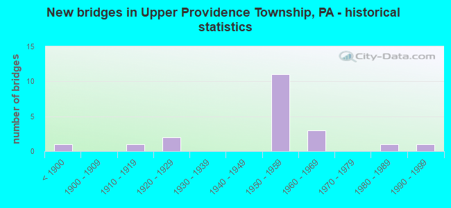
- New bridges - historical statistics
- 1Before 1900
- 11910-1919
- 21920-1929
- 111950-1959
- 31960-1969
- 11980-1989
- 11990-1999

- Reconstructed bridges - Historical Statistics
- 11970-1979
- 11980-1989
- 41990-1999


- Bridge Condition - Deck
- 9.1%Good
- 63.6%Satisfactory
- 27.3%Fair

- Bridge Condition - Superstructure
- 25.0%Good
- 41.7%Satisfactory
- 33.3%Fair

- Bridge Condition - Substructure
- 16.7%Good
- 33.3%Satisfactory
- 33.3%Fair
- 16.7%Poor

- Bridge Condition - Channel
- 16.7%Good
- 33.3%Satisfactory
- 50.0%Fair
Find on map >> Show street view
Structure Number: 14793, Location: 1.5MI.S.PA 252 33K04 (Lat: 39.925544, Lng: -75.408153), Route carried "on" structure: US 1, Year Built: 1959, Year Reconstructed: 1995, Status: Open, Structure Length: 9.24m (30.31ft), Average Daily Traffic: 27,374 (year 2020), Truck Traffic: 1%, Average Future Daily Traffic: 50,702 (year 2032), Design Load: HS 20+Mod, Features Intersected: RIDLEY CK.RD;RIDLEY CK., Facility Carried by Structure: MEDIA BY-PASS
Minimum Vertical Clearance: 30+ m (98+ ft), Kilometerpoint: 17.788, Lanes on structure: 2, Lanes under structure: 2, Base Highway Network: Yes, Owner: State Highway Agency, Approaching Roadway Width: 21.9m (71.9ft), Skew: 30 degrees, Material/Design: Prestressed concrete, Design/Construction: Box Beam or Girders - Multiple, Number Of Spans In Main Unit: 4, Length of Maximum Span: 28.3m (92.8ft), Curb or Sidewalk Widths: Left: 0.2m (0.7ft), Right: 0.2m (0.7ft), Curb-To-Curb Width: 17.7m (58.1ft), Out-to-Out Width: 20.0m (65.6ft)
Condition: Deck: Fair, Superstructure: Fair, Substructure: Fair, Channel: Satisfactory, Inventory Rating: 35.4 metric tons, Method Used To Determine Inventory Rating: Load Factor (LF), Structural Evaluation: Somewhat better than minimum adequacy, Deck Geometry: Superior to present desirable criteria, Underclear: Superior to present desirable criteria, Waterway Adequacy: Superior to present desirable criteria, Approach Roadway Alignment: Equal to present desirable criteria, Length Of Structure Improvement: 9.20m (30.18ft), Designated Inspection Frequency: Every 24 months, Inspection Date: December 2019, Bridge Improvement Cost: $44,000, Roadway Improvement Cost: $128,000, Total Project Cost: $588,000, Wearing Surface/Protective System: Wearing Surface: Latex Concrete
Find on map >> Show street view
Structure Number: 14794, Location: .5MI.N.OF MEDIA 34B03 (Lat: 39.932533, Lng: -75.398083), Route carried "on" structure: State highway , Year Built: 1959, Status: Open, Structure Length: 3.44m (11.29ft), Average Daily Traffic: 3,183 (year 2021), Truck Traffic: 3%, Average Future Daily Traffic: 5,304 (year 2032), Design Load: HS 20+Mod, Features Intersected: MEDIA BY-PASS, Facility Carried by Structure: ORANGE STREET
Minimum Vertical Clearance: 30+ m (98+ ft), Kilometerpoint: 0.000, Lanes on structure: 2, Lanes under structure: 4, Owner: State Highway Agency, Approaching Roadway Width: 7.6m (24.9ft), Material/Design: Prestressed concrete, Design/Construction: Box Beam or Girders - Multiple, Number Of Spans In Main Unit: 3, Length of Maximum Span: 26.2m (86.0ft), Curb or Sidewalk Widths: Left: 1.5m (4.9ft), Right: 0.1m (0.3ft), Curb-To-Curb Width: 11.2m (36.7ft), Out-to-Out Width: 12.8m (42.0ft)
Condition: Deck: Fair, Superstructure: Satisfactory, Substructure: Fair, Operating Rating: 90.7 metric tons, Method Used To Determine Operating Rating: Load Factor (LF), Inventory Rating: 38.1 metric tons, Method Used To Determine Inventory Rating: Load Factor (LF), Structural Evaluation: Somewhat better than minimum adequacy, Deck Geometry: Somewhat better than minimum adequacy, Underclear: Meets minimum limits, Approach Roadway Alignment: Equal to present desirable criteria, Length Of Structure Improvement: 4.30m (14.11ft), Designated Inspection Frequency: Every 24 months, Inspection Date: November 2019, Bridge Improvement Cost: $13,000, Roadway Improvement Cost: $38,000, Total Project Cost: $176,000, Deck Structure Type: Concrete Cast-file-Place, Wearing Surface/Protective System: Wearing Surface: Monolithic Concrete
Find on map >> Show street view
Structure Number: 14798, Location: .5MI.NORTH PA-252 34D02 (Lat: 39.936317, Lng: -75.379997), Route carried "on" structure: US 1, Year Built: 1959, Year Reconstructed: 1995, Status: Open, Structure Length: 1.40m (4.59ft), Average Daily Traffic: 52,136 (year 2022), Truck Traffic: 3%, Average Future Daily Traffic: 68,574 (year 2032), Design Load: HS 20+Mod, Features Intersected: SANDY BANK ROAD(T359), Facility Carried by Structure: MEDIA BY-PASS
Minimum Vertical Clearance: 30+ m (98+ ft), Kilometerpoint: 20.709, Lanes on structure: 2, Lanes under structure: 2, Base Highway Network: Yes, Owner: State Highway Agency, Approaching Roadway Width: 26.8m (87.9ft), Skew: 33 degrees, Material/Design: Prestressed concrete, Design/Construction: Box Beam or Girders - Multiple, Number Of Spans In Main Unit: 1, Length of Maximum Span: 13.4m (44.0ft), Curb-To-Curb Width: 25.0m (82.0ft), Out-to-Out Width: 26.7m (87.6ft)
Condition: Deck: Satisfactory, Superstructure: Satisfactory, Substructure: Fair, Operating Rating: 87.1 metric tons, Method Used To Determine Operating Rating: Load Factor (LF), Inventory Rating: 51.7 metric tons, Method Used To Determine Inventory Rating: Load Factor (LF), Structural Evaluation: Somewhat better than minimum adequacy, Deck Geometry: Superior to present desirable criteria, Underclear: Meets minimum limits, Approach Roadway Alignment: Equal to present desirable criteria, Length Of Structure Improvement: 1.40m (4.59ft), Designated Inspection Frequency: Every 24 months, Inspection Date: September 2021, Bridge Improvement Cost: $14,000, Roadway Improvement Cost: $77,000, Total Project Cost: $188,000, Deck Structure Type: Concrete Cast-file-Place, Wearing Surface/Protective System: Wearing Surface: Latex Concrete
Find on map >> Show street view
Structure Number: 148, Location: 1MI.NORTH PA 252 34E02 (Lat: 39.936483, Lng: -75.374072), Route carried "on" structure: US 1, Year Built: 1959, Year Reconstructed: 1995, Status: Open, Structure Length: 1.77m (5.81ft), Average Daily Traffic: 67,499 (year 2022), Truck Traffic: 4%, Average Future Daily Traffic: 57,718 (year 2032), Design Load: HS 20+Mod, Features Intersected: STATE ROAD, Facility Carried by Structure: MEDIA BY-PASS
Minimum Vertical Clearance: 30+ m (98+ ft), Kilometerpoint: 21.218, Lanes on structure: 2, Lanes under structure: 2, Base Highway Network: Yes, Owner: State Highway Agency, Approaching Roadway Width: 29.9m (98.1ft), Skew: 34 degrees, Material/Design: Prestressed concrete, Design/Construction: Box Beam or Girders - Multiple, Number Of Spans In Main Unit: 1, Length of Maximum Span: 17.1m (56.1ft), Curb-To-Curb Width: 26.2m (86.0ft), Out-to-Out Width: 28.8m (94.5ft)
Condition: Deck: Satisfactory, Superstructure: Satisfactory, Substructure: Satisfactory, Operating Rating: 83.5 metric tons, Method Used To Determine Operating Rating: Load Factor (LF), Inventory Rating: 41.7 metric tons, Method Used To Determine Inventory Rating: Load Factor (LF), Structural Evaluation: Equal to present minimum criteria, Deck Geometry: Superior to present desirable criteria, Underclear: Better than present minimum criteria, Approach Roadway Alignment: Equal to present desirable criteria, Length Of Structure Improvement: 1.80m (5.91ft), Designated Inspection Frequency: Every 24 months, Inspection Date: October 2021, Bridge Improvement Cost: $16,000, Roadway Improvement Cost: $71,000, Total Project Cost: $210,000, Deck Structure Type: Concrete Cast-file-Place, Wearing Surface/Protective System: Wearing Surface: Bituminous
Find on map >> Show street view
Structure Number: 14801, Location: MARPLE;UPPER PROV. 34F02 (Lat: 39.936531, Lng: -75.370544), Route carried "on" structure: US 1, Year Built: 1958, Year Reconstructed: 1990, Status: Open, Structure Length: 13.14m (43.11ft), Average Daily Traffic: 77,784 (year 2022), Truck Traffic: 6%, Average Future Daily Traffic: 48,333 (year 2032), Design Load: HS 25 or greater, Features Intersected: CRUM CREEK,CRUM CREEK RD, Facility Carried by Structure: MEDIA BY-PASS
Minimum Vertical Clearance: 30+ m (98+ ft), Kilometerpoint: 21.218, Lanes on structure: 2, Lanes under structure: 2, Base Highway Network: Yes, Owner: State Highway Agency, Approaching Roadway Width: 30.2m (99.1ft), Skew: 30 degrees, Material/Design: Prestressed concrete, Design/Construction: Box Beam or Girders - Multiple, Number Of Spans In Main Unit: 6, Length of Maximum Span: 23.8m (78.1ft), Curb or Sidewalk Widths: Left: 0.2m (0.7ft), Right: 0.2m (0.7ft), Curb-To-Curb Width: 30.2m (99.1ft), Out-to-Out Width: 31.0m (101.7ft)
Condition: Deck: Satisfactory, Superstructure: Fair, Substructure: Fair, Channel: Satisfactory, Inventory Rating: 45.4 metric tons, Method Used To Determine Inventory Rating: Load Factor (LF), Structural Evaluation: Somewhat better than minimum adequacy, Deck Geometry: Superior to present desirable criteria, Underclear: Superior to present desirable criteria, Waterway Adequacy: Superior to present desirable criteria, Approach Roadway Alignment: Equal to present desirable criteria, Length Of Structure Improvement: 14.20m (46.59ft), Designated Inspection Frequency: Every 24 months, Inspection Date: November 2019, Deck Structure Type: Concrete Cast-file-Place, Wearing Surface/Protective System: Wearing Surface: Monolithic Concrete, Deck Protection: Epoxy Coated Reinforcing
Find on map >> Show street view
Structure Number: 14949, Location: 1MI.NORTH MEDIA 34C02 (Lat: 39.936000, Lng: -75.391786), Route carried "on" structure: State highway 252, Year Built: 1960, Status: Open, Structure Length: 4.63m (15.19ft), Average Daily Traffic: 28,316 (year 2021), Truck Traffic: 5%, Average Future Daily Traffic: 34,258 (year 2032), Design Load: HS 20, Features Intersected: MEDIA BY-PASS, Facility Carried by Structure: PROVIDENCE ROAD
Minimum Vertical Clearance: 30+ m (98+ ft), Kilometerpoint: 6.767, Lanes on structure: 4, Lanes under structure: 4, Base Highway Network: Yes, Owner: State Highway Agency, Approaching Roadway Width: 18.3m (60.0ft), Skew: 22 degrees, Material/Design: Prestressed concrete, Design/Construction: Box Beam or Girders - Multiple, Number Of Spans In Main Unit: 3, Length of Maximum Span: 28.3m (92.8ft), Curb or Sidewalk Widths: Left: 1.5m (4.9ft), Right: 1.5m (4.9ft), Curb-To-Curb Width: 17.2m (56.4ft), Out-to-Out Width: 21.0m (68.9ft)
Condition: Deck: Satisfactory, Superstructure: Satisfactory, Substructure: Satisfactory, Inventory Rating: 37.2 metric tons, Method Used To Determine Inventory Rating: Load Factor (LF), Structural Evaluation: Equal to present minimum criteria, Deck Geometry: Somewhat better than minimum adequacy, Underclear: High priority of corrective action, Approach Roadway Alignment: Equal to present desirable criteria, Length Of Structure Improvement: 5.60m (18.37ft), Designated Inspection Frequency: Every 24 months, Inspection Date: October 2019, Deck Structure Type: Concrete Cast-file-Place, Wearing Surface/Protective System: Wearing Surface: Latex Concrete
Find on map >> Show street view
Structure Number: 1532, Location: .7MI.S.BALT. PK. 34C07 (Lat: 39.906303, Lng: -75.388717), Route carried "on" structure: State highway , Year Built: 1895, Status: Posted for load, Structure Length: 2.32m (7.61ft), Average Daily Traffic: 6,779 (year 2022), Truck Traffic: 3%, Average Future Daily Traffic: 7,843 (year 2032), Design Load: H 15, Features Intersected: SEPTA, Facility Carried by Structure: MANCHESTER AVENUE
Minimum Vertical Clearance: 30+ m (98+ ft), Kilometerpoint: 3.880, Lanes on structure: 2, Owner: State Highway Agency, Approaching Roadway Width: 7.3m (24.0ft), Skew: 4 degrees, Material/Design: Steel, Design/Construction: Girder and Floorbeam System, Number Of Spans In Main Unit: 3, Length of Maximum Span: 12.8m (42.0ft), Curb or Sidewalk Widths: Left: 1.8m (5.9ft), Right: 1.8m (5.9ft), Curb-To-Curb Width: 11.8m (38.7ft), Out-to-Out Width: 15.4m (50.5ft)
Condition: Deck: Fair, Superstructure: Fair, Substructure: Poor, Operating Rating: 41.7 metric tons, Method Used To Determine Operating Rating: Field evaluation and documented engineering judgment, Inventory Rating: 20.9 metric tons, Method Used To Determine Inventory Rating: Field evaluation and documented engineering judgment, Structural Evaluation: Meets minimum limits, Deck Geometry: Somewhat better than minimum adequacy, Underclear: High priority of replacement, Approach Roadway Alignment: Somewhat better than minimum adequacy, Length Of Structure Improvement: 2.90m (9.51ft), Designated Inspection Frequency: Every 24 months, Critical Feature Inspection Frequency: Every 24 months, Other Special Inspection Frequency: Every 6 months, Inspection Date: October 2020, Critical Feature Inspection Date: October 2020, Other Special Inspection Date: April 2021, Bridge Improvement Cost: $121,000, Roadway Improvement Cost: $357,000, Total Project Cost: $1,636,000, Deck Structure Type: Concrete Cast-file-Place, Wearing Surface/Protective System: Wearing Surface: Bituminous
Find on map >> Show street view
Structure Number: 15322, Location: .5MI S.MEDIA 34B08 (Lat: 39.905469, Lng: -75.396414), Route carried "on" structure: State highway , Year Built: 1998, Status: Open, Structure Length: 2.16m (7.09ft), Average Daily Traffic: 2,107 (year 2022), Truck Traffic: 2%, Average Future Daily Traffic: 6,735 (year 2032), Design Load: HS 25 or greater, Features Intersected: RIDLEY CREEK, Facility Carried by Structure: BORTON DALE ROAD
Minimum Vertical Clearance: 30+ m (98+ ft), Kilometerpoint: 0.674, Lanes on structure: 2, Owner: State Highway Agency, Approaching Roadway Width: 7.6m (24.9ft), Skew: 3 degrees, Material/Design: Steel, Design/Construction: Stringer/Multi-beam, Number Of Spans In Main Unit: 1, Length of Maximum Span: 20.7m (67.9ft), Curb or Sidewalk Widths: Left: 0.2m (0.7ft), Right: 0.2m (0.7ft), Curb-To-Curb Width: 8.5m (27.9ft), Out-to-Out Width: 9.8m (32.2ft)
Condition: Deck: Satisfactory, Superstructure: Good, Substructure: Good, Channel: Fair, Operating Rating: 67.1 metric tons, Method Used To Determine Operating Rating: Load Factor (LF), Inventory Rating: 39.9 metric tons, Method Used To Determine Inventory Rating: Load Factor (LF), Structural Evaluation: Better than present minimum criteria, Deck Geometry: Meets minimum limits, Waterway Adequacy: Equal to present minimum criteria, Approach Roadway Alignment: Somewhat better than minimum adequacy, Length Of Structure Improvement: 2.90m (9.51ft), Designated Inspection Frequency: Every 24 months, Inspection Date: December 2019, Deck Structure Type: Concrete Cast-file-Place, Wearing Surface/Protective System: Wearing Surface: Monolithic Concrete, Deck Protection: Epoxy Coated Reinforcing
Find on map >> Show street view
Structure Number: 15323, Location: S.BALTIMORE PIKE 34B06 (Lat: 39.913942, Lng: -75.394158), Route carried "on" structure: State highway , Year Built: 1918, Year Reconstructed: 1983, Status: Open, Structure Length: 1.25m (4.10ft), Average Daily Traffic: 2,107 (year 2022), Truck Traffic: 2%, Average Future Daily Traffic: 6,735 (year 2032), Design Load: HS 20, Features Intersected: SEPTA (P&W), Facility Carried by Structure: ORANGE STREET
Minimum Vertical Clearance: 30+ m (98+ ft), Kilometerpoint: 1.571, Lanes on structure: 2, Owner: State Highway Agency, Approaching Roadway Width: 8.2m (26.9ft), Skew: 1 degrees, Material/Design: Prestressed concrete, Design/Construction: Box Beam or Girders - Single/Spread, Number Of Spans In Main Unit: 1, Length of Maximum Span: 11.3m (37.1ft), Curb or Sidewalk Widths: Left: 1.6m (5.2ft), Right: 1.6m (5.2ft), Curb-To-Curb Width: 7.9m (25.9ft), Out-to-Out Width: 11.7m (38.4ft)
Condition: Deck: Good, Superstructure: Good, Substructure: Satisfactory, Operating Rating: 53.5 metric tons, Method Used To Determine Operating Rating: Load Factor (LF), Inventory Rating: 29.9 metric tons, Method Used To Determine Inventory Rating: Load Factor (LF), Structural Evaluation: Equal to present minimum criteria, Deck Geometry: High priority of corrective action, Underclear: High priority of corrective action, Approach Roadway Alignment: Equal to present desirable criteria, Length Of Structure Improvement: 1.70m (5.58ft), Designated Inspection Frequency: Every 24 months, Inspection Date: November 2019, Deck Structure Type: Concrete Cast-file-Place, Wearing Surface/Protective System: Wearing Surface: Monolithic Concrete, Deck Protection: Epoxy Coated Reinforcing
Find on map >> Show street view
Structure Number: 15343, Location: NORTH OF MEDIA 33K04 (Lat: 39.926725, Lng: -75.408881), Route carried "on" structure: State highway , Year Built: 1986, Status: Open, Structure Length: 5.73m (18.80ft), Average Daily Traffic: 5,621 (year 2022), Truck Traffic: 5%, Average Future Daily Traffic: 8,117 (year 2032), Design Load: HS 25 or greater, Features Intersected: RIDLEY CREEK, Facility Carried by Structure: ROSE TREE ROAD
Minimum Vertical Clearance: 30+ m (98+ ft), Kilometerpoint: 2.094, Lanes on structure: 2, Owner: State Highway Agency, Approaching Roadway Width: 9.8m (32.2ft), Material/Design: Prestressed concrete, Design/Construction: Box Beam or Girders - Multiple, Number Of Spans In Main Unit: 3, Length of Maximum Span: 18.9m (62.0ft), Curb or Sidewalk Widths: Left: 0.2m (0.7ft), Right: 0.2m (0.7ft), Curb-To-Curb Width: 9.4m (30.8ft), Out-to-Out Width: 10.6m (34.8ft)
Condition: Deck: Satisfactory, Superstructure: Good, Substructure: Good, Channel: Fair, Operating Rating: 85.3 metric tons, Method Used To Determine Operating Rating: Load Factor (LF), Inventory Rating: 35.4 metric tons, Method Used To Determine Inventory Rating: Load Factor (LF), Structural Evaluation: Better than present minimum criteria, Deck Geometry: High priority of corrective action, Waterway Adequacy: Equal to present minimum criteria, Approach Roadway Alignment: Equal to present desirable criteria, Length Of Structure Improvement: 6.70m (21.98ft), Designated Inspection Frequency: Every 24 months, Inspection Date: October 2019, Deck Structure Type: Concrete Cast-file-Place, Wearing Surface/Protective System: Wearing Surface: Monolithic Concrete, Deck Protection: Epoxy Coated Reinforcing
Find on map >> Show street view
Structure Number: 15347, Location: SPRINGTON RESERV. 24J10 (Lat: 39.962994, Lng: -75.419583), Route carried "on" structure: State highway , Year Built: 1920, Year Reconstructed: 1987, Status: Open, Structure Length: 2.44m (8.01ft), Average Daily Traffic: 4,377 (year 2022), Truck Traffic: 3%, Average Future Daily Traffic: 5,859 (year 2032), Design Load: HS 25 or greater, Features Intersected: CRUM CREEK;SPRINGTON RES, Facility Carried by Structure: BISHOP HOLLOW ROAD
Minimum Vertical Clearance: 30+ m (98+ ft), Kilometerpoint: 5.882, Lanes on structure: 2, Owner: State Highway Agency, Approaching Roadway Width: 10.4m (34.1ft), Material/Design: Prestressed concrete, Design/Construction: Box Beam or Girders - Multiple, Number Of Spans In Main Unit: 1, Length of Maximum Span: 24.1m (79.1ft), Curb or Sidewalk Widths: Left: 0.2m (0.7ft), Right: 0.2m (0.7ft), Curb-To-Curb Width: 10.0m (32.8ft), Out-to-Out Width: 11.1m (36.4ft)
Condition: Deck: Satisfactory, Superstructure: Satisfactory, Substructure: Satisfactory, Channel: Good, Inventory Rating: 55.3 metric tons, Method Used To Determine Inventory Rating: Load Factor (LF), Structural Evaluation: Equal to present minimum criteria, Deck Geometry: Meets minimum limits, Waterway Adequacy: Better than present minimum criteria, Approach Roadway Alignment: Equal to present minimum criteria, Length Of Structure Improvement: 3.20m (10.50ft), Designated Inspection Frequency: Every 24 months, Underwater Inspection Frequency: Every 60 months, Inspection Date: November 2020, Underwater Inspection Date: June 2017, Deck Structure Type: Concrete Cast-file-Place, Wearing Surface/Protective System: Wearing Surface: Monolithic Concrete, Deck Protection: Epoxy Coated Reinforcing
Find on map >> Show street view
Structure Number: 15387, Location: 1.1 Mi W SR252 ADC 3696H6 (Lat: 39.902531, Lng: -75.392189), Route carried "on" structure: City street , Year Built: 1925, Status: Open, Structure Length: 2.13m (6.99ft), Average Daily Traffic: 5,895 (year 2017), Truck Traffic: 7%, Average Future Daily Traffic: 7,369 (year 2032), Design Load: H 20, Features Intersected: RIDLEY CREEK, Facility Carried by Structure: MANCHESTER ROAD
Minimum Vertical Clearance: 30+ m (98+ ft), Kilometerpoint: 0.000, Lanes on structure: 2, Owner: County Highway Agency, Approaching Roadway Width: 9.8m (32.2ft), Material/Design: Concrete, Design/Construction: Arch - Deck, Number Of Spans In Main Unit: 1, Length of Maximum Span: 21.3m (69.9ft), Curb-To-Curb Width: 7.9m (25.9ft), Out-to-Out Width: 9.8m (32.2ft)
Condition: Superstructure: Fair, Substructure: Poor, Channel: Fair, Operating Rating: 50.8 metric tons, Method Used To Determine Operating Rating: Load Factor (LF), Inventory Rating: 30.8 metric tons, Method Used To Determine Inventory Rating: Load Factor (LF), Structural Evaluation: Meets minimum limits, Deck Geometry: High priority of replacement, Waterway Adequacy: Equal to present desirable criteria, Approach Roadway Alignment: Equal to present desirable criteria, Length Of Structure Improvement: 2.10m (6.89ft), Designated Inspection Frequency: Every 24 months, Inspection Date: October 2019, Bridge Improvement Cost: $14,000, Roadway Improvement Cost: $40,000, Total Project Cost: $183,000
Find on map >> Show street view
Structure Number: 14793, Location: 1.5MI.S.PA 252 33K04 (Lat: 39.925544, Lng: -75.408153), Route carried "under" structure: State highway , Year Built: 1959, Structure Length: 0. m, Average Daily Traffic: 2,536 (year 2021), Truck Traffic: 4%, Features Intersected: RIDLEY CK.RD;RIDLEY CK., Facility Carried by Structure: MEDIA BY-PASS
Minimum Vertical Clearance: 10.46m (34.32ft), Kilometerpoint: 1.160, Lanes on structure: 2, Lanes under structure: 2, Material/Design: Prestressed concrete, Design/Construction: Box Beam or Girders - Multiple, Length of Maximum Span: 28.3m (92.8ft)
Find on map >> Show street view
Structure Number: 14794, Location: .5MI.N.OF MEDIA 34B03 (Lat: 39.932533, Lng: -75.398083), Route carried "under" structure: US 1, Year Built: 1959, Structure Length: 0. m, Average Daily Traffic: 13,540 (year 2020), Truck Traffic: 1%, Features Intersected: MEDIA BY-PASS, Facility Carried by Structure: ORANGE STREET
Minimum Vertical Clearance: 4.82m (15.81ft), Kilometerpoint: 19.032, Lanes on structure: 2, Lanes under structure: 2, Material/Design: Prestressed concrete, Design/Construction: Box Beam or Girders - Multiple, Length of Maximum Span: 26.2m (86.0ft)
Find on map >> Show street view
Structure Number: 14794, Location: .5MI.N.OF MEDIA 34B03 (Lat: 39.932533, Lng: -75.398083), Route carried "under" structure: US 1, Year Built: 1959, Structure Length: 0. m, Average Daily Traffic: 13,834 (year 2020), Truck Traffic: 1%, Features Intersected: MEDIA BY-PASS, Facility Carried by Structure: ORANGE STREET
Minimum Vertical Clearance: 4.70m (15.42ft), Kilometerpoint: 18.908, Lanes on structure: 2, Lanes under structure: 2, Material/Design: Prestressed concrete, Design/Construction: Box Beam or Girders - Multiple, Length of Maximum Span: 26.2m (86.0ft)
Find on map >> Show street view
Structure Number: 14798, Location: .5MI.NORTH PA-252 34D02 (Lat: 39.936317, Lng: -75.379997), Route carried "under" structure: City street 7210, Year Built: 1959, Structure Length: 0. m, Average Daily Traffic: 450 (year 1980), Truck Traffic: 2%, Features Intersected: SANDY BANK ROAD(T359), Facility Carried by Structure: MEDIA BY-PASS
Minimum Vertical Clearance: 4.57m (14.99ft), Kilometerpoint: 0.000, Lanes on structure: 2, Lanes under structure: 2, Material/Design: Prestressed concrete, Design/Construction: Box Beam or Girders - Multiple, Length of Maximum Span: 13.4m (44.0ft)
Find on map >> Show street view
Structure Number: 148, Location: 1MI.NORTH PA 252 34E02 (Lat: 39.936483, Lng: -75.374072), Route carried "under" structure: State highway , Year Built: 1959, Structure Length: 0. m, Average Daily Traffic: 4,391 (year 2020), Truck Traffic: 3%, Features Intersected: STATE ROAD, Facility Carried by Structure: MEDIA BY-PASS
Minimum Vertical Clearance: 4.88m (16.01ft), Kilometerpoint: 0.660, Lanes on structure: 2, Lanes under structure: 2, Material/Design: Prestressed concrete, Design/Construction: Box Beam or Girders - Multiple, Length of Maximum Span: 17.1m (56.1ft)
Find on map >> Show street view
Structure Number: 14801, Location: MARPLE;UPPER PROV. 34F02 (Lat: 39.936531, Lng: -75.370544), Route carried "under" structure: State highway , Year Built: 1958, Structure Length: 0. m, Average Daily Traffic: 328 (year 2020), Truck Traffic: 2%, Features Intersected: CRUM CREEK,CRUM CREEK RD, Facility Carried by Structure: MEDIA BY-PASS
Minimum Vertical Clearance: 8.63m (28.31ft), Kilometerpoint: 0.904, Lanes on structure: 2, Lanes under structure: 2, Material/Design: Prestressed concrete, Design/Construction: Box Beam or Girders - Multiple, Length of Maximum Span: 23.8m (78.1ft)
Find on map >> Show street view
Structure Number: 14949, Location: 1MI.NORTH MEDIA 34C02 (Lat: 39.936000, Lng: -75.391786), Route carried "under" structure: US 1, Year Built: 1960, Structure Length: 0. m, Average Daily Traffic: 26,974 (year 2022), Truck Traffic: 3%, Features Intersected: MEDIA BY-PASS, Facility Carried by Structure: PROVIDENCE ROAD
Minimum Vertical Clearance: 4.80m (15.75ft), Kilometerpoint: 19.703, Lanes on structure: 4, Lanes under structure: 2, Material/Design: Prestressed concrete, Design/Construction: Box Beam or Girders - Multiple, Length of Maximum Span: 28.3m (92.8ft)
Find on map >> Show street view
Structure Number: 14949, Location: 1MI.NORTH MEDIA 34C02 (Lat: 39.936000, Lng: -75.391786), Route carried "under" structure: US 1, Year Built: 1960, Structure Length: 0. m, Average Daily Traffic: 25,162 (year 2022), Truck Traffic: 3%, Features Intersected: MEDIA BY-PASS, Facility Carried by Structure: PROVIDENCE ROAD
Minimum Vertical Clearance: 4.91m (16.11ft), Kilometerpoint: 19.594, Lanes on structure: 4, Lanes under structure: 2, Material/Design: Prestressed concrete, Design/Construction: Box Beam or Girders - Multiple, Length of Maximum Span: 28.3m (92.8ft)