Bridge Statistics for University Park, Illinois (IL)
Condition, Traffic, Stress, Structural Evaluation, Project Costs
- National Bridge Inventory (NBI) Statistics
- 16Number of bridges
- 98ft / 29.6mTotal length
- $89,000Total costs
- 194,325Total average daily traffic
- 35,604Total average daily truck traffic
- National Bridge Inventory (NBI) Registered Bridges for University Park
- No street view available for this location
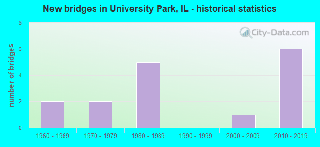
- New bridges - historical statistics
- 21960-1969
- 21970-1979
- 51980-1989
- 12000-2009
- 62010-2019


- Bridge Condition - Deck
- 14.3%Very good
- 28.6%Satisfactory
- 42.9%Fair
- 14.3%Poor

- Bridge Condition - Superstructure
- 14.3%Very good
- 28.6%Good
- 57.1%Fair

- Bridge Condition - Substructure
- 57.1%Good
- 14.3%Satisfactory
- 28.6%Fair

- Bridge Condition - Channel
- 25.0%Very good
- 41.7%Good
- 25.0%Satisfactory
- 8.3%Fair

- Bridge Condition - Culverts
- 42.9%Very good
- 57.1%Good
Find on map >> Show street view
Structure Number: 161108, Location: 2.5 M S US 30 (Lat: 41.469761, Lng: -87.752883), Route carried "on" structure: Other road , Year Built: 1966, Year Reconstructed: 2021, Status: Open, Structure Length: 7.38m (24.21ft), Average Daily Traffic: 2,350 (year 2018), Truck Traffic: 6%, Average Future Daily Traffic: 2,833 (year 2032), Design Load: HS 20, Features Intersected: I- 57, Facility Carried by Structure: STEGER RD
Minimum Vertical Clearance: 30+ m (98+ ft), Kilometerpoint: 3.074, Lanes on structure: 2, Lanes under structure: 4, Owner: State Highway Agency, Approaching Roadway Width: 7.3m (24.0ft), Skew: 1 degrees, Material/Design: Steel continuous, Design/Construction: Stringer/Multi-beam, Number Of Spans In Main Unit: 2, Number Of Approach Spans: 2, Length of Maximum Span: 27.5m (90.2ft), Curb or Sidewalk Widths: Left: 1.5m (4.9ft), Right: 1.5m (4.9ft), Curb-To-Curb Width: 9.1m (29.9ft), Out-to-Out Width: 12.8m (42.0ft)
Condition: Deck: Poor, Superstructure: Fair, Substructure: Fair, Operating Rating: 55.7 metric tons, Method Used To Determine Operating Rating: Load Factor (LF) rating reported by rating factor (RF) method using MS18 loading, Inventory Rating: 33.4 metric tons, Method Used To Determine Inventory Rating: Load Factor (LF) rating reported by rating factor (RF) method using MS18 loading, Structural Evaluation: Somewhat better than minimum adequacy, Deck Geometry: Meets minimum limits, Underclear: Somewhat better than minimum adequacy, Approach Roadway Alignment: Equal to present desirable criteria, Designated Inspection Frequency: Every 24 months, Inspection Date: November 2020, Deck Structure Type: Concrete Cast-file-Place, Wearing Surface/Protective System: Wearing Surface: Other
Find on map >> Show street view
Structure Number: 990526, Location: .9M S OF STEGER RD (Lat: 41.455972, Lng: -87.757817), Route carried "on" structure: Other road , Year Built: 2013, Status: Open, Structure Length: 7.98m (26.18ft), Average Daily Traffic: 9,650 (year 2019), Truck Traffic: 18%, Average Future Daily Traffic: 5,000 (year 2032), Design Load: HS 25 or greater, Features Intersected: I- 57, Facility Carried by Structure: STUENKEL RD
Minimum Vertical Clearance: 30+ m (98+ ft), Kilometerpoint: 12.311, Lanes on structure: 4, Lanes under structure: 4, Base Highway Network: Yes, Owner: State Highway Agency, Approaching Roadway Width: 17.1m (56.1ft), Skew: 30 degrees, Material/Design: Steel continuous, Design/Construction: Stringer/Multi-beam, Number Of Spans In Main Unit: 2, Length of Maximum Span: 42.8m (140.4ft), Curb or Sidewalk Widths: Left: 2.1m (6.9ft), Right: 4.3m (14.1ft), Curb-To-Curb Width: 17.1m (56.1ft), Out-to-Out Width: 32.5m (106.6ft)
Condition: Deck: Satisfactory, Superstructure: Good, Substructure: Good, Operating Rating: 66.4 metric tons, Method Used To Determine Operating Rating: Load and Resistance Factor Rating (LRFR) rating reported by rating factor(RF) method using HL-93 loadings, Inventory Rating: 51.2 metric tons, Method Used To Determine Inventory Rating: Load and Resistance Factor Rating (LRFR) rating reported by rating factor(RF) method using HL-93 loadings, Structural Evaluation: Better than present minimum criteria, Deck Geometry: Somewhat better than minimum adequacy, Underclear: Superior to present desirable criteria, Approach Roadway Alignment: Equal to present desirable criteria, Designated Inspection Frequency: Every 24 months, Inspection Date: Febuary 2021, Deck Structure Type: Concrete Cast-file-Place, Wearing Surface/Protective System: Deck Protection: Epoxy Coated Reinforcing
Find on map >> Show street view
Structure Number: 990608, Location: 0.15M N of Stuenkel (Lat: 41.458181, Lng: -87.756778), Route carried "on" structure: Interstate 57, Year Built: 2015, Status: Open, Structure Length: 0.92m (3.02ft), Average Daily Traffic: 44,300 (year 2021), Truck Traffic: 21%, Average Future Daily Traffic: 93,000 (year 2040), Design Load: HS 25 or greater, Features Intersected: EAST BR HICKORY CRK
Minimum Vertical Clearance: 30+ m (98+ ft), Kilometerpoint: 542.849, Lanes on structure: 4, Base Highway Network: Yes, Owner: State Highway Agency, Approaching Roadway Width: 26.2m (86.0ft), Skew: 3 degrees, Material/Design: Concrete, Design/Construction: Culvert, Number Of Spans In Main Unit: 3, Length of Maximum Span: 2.7m (8.9ft)
Condition: Channel: Satisfactory, Culverts: Good, Operating Rating: 55.1 metric tons, Method Used To Determine Operating Rating: Load and Resistance Factor Rating (LRFR) rating reported by rating factor(RF) method using HL-93 loadings, Inventory Rating: 42.4 metric tons, Method Used To Determine Inventory Rating: Load and Resistance Factor Rating (LRFR) rating reported by rating factor(RF) method using HL-93 loadings, Structural Evaluation: Better than present minimum criteria, Waterway Adequacy: Equal to present desirable criteria, Approach Roadway Alignment: Equal to present desirable criteria, Designated Inspection Frequency: Every 24 months, Inspection Date: Febuary 2021
Find on map >> Show street view
Structure Number: 990609, Location: 3.5 M E of US 30 (Lat: 41.458844, Lng: -87.757714), Route carried "on" structure: Other road , Year Built: 2015, Status: Open, Structure Length: 0.82m (2.69ft), Average Daily Traffic: 4,000 (year 2019), Truck Traffic: 20%, Average Future Daily Traffic: 1,000 (year 2032), Design Load: HS 25 or greater, Features Intersected: EAST BR HICKORY CRK, Facility Carried by Structure: I- 57 SB RMP STUEN
Minimum Vertical Clearance: 30+ m (98+ ft), Kilometerpoint: 0.451, Lanes on structure: 1, Base Highway Network: Yes (Inventory Route: 10057041, Subroute: 80), Owner: State Highway Agency, Approaching Roadway Width: 7.3m (24.0ft), Skew: 1 degrees, Material/Design: Concrete, Design/Construction: Culvert, Number Of Spans In Main Unit: 3, Length of Maximum Span: 2.7m (8.9ft)
Condition: Channel: Satisfactory, Culverts: Good, Operating Rating: 74.8 metric tons, Method Used To Determine Operating Rating: Load and Resistance Factor Rating (LRFR) rating reported by rating factor(RF) method using HL-93 loadings, Inventory Rating: 57.7 metric tons, Method Used To Determine Inventory Rating: Load and Resistance Factor Rating (LRFR) rating reported by rating factor(RF) method using HL-93 loadings, Structural Evaluation: Better than present minimum criteria, Waterway Adequacy: Equal to present desirable criteria, Approach Roadway Alignment: Equal to present desirable criteria, Designated Inspection Frequency: Every 24 months, Inspection Date: Febuary 2021
Find on map >> Show street view
Structure Number: 99061, Location: 0.2M W Central Av. (Lat: 41.456022, Lng: -87.752453), Route carried "on" structure: Other road , Year Built: 2015, Status: Open, Structure Length: 0.93m (3.05ft), Average Daily Traffic: 4,825 (year 2019), Truck Traffic: 18%, Average Future Daily Traffic: 5,000 (year 2040), Design Load: HS 25 or greater, Features Intersected: East Br Hickory Cr, Facility Carried by Structure: FAU-1637 StuenkelR
Minimum Vertical Clearance: 30+ m (98+ ft), Kilometerpoint: 12.762, Lanes on structure: 2, Base Highway Network: Yes, Owner: City or Municipal Highway Agency, Approaching Roadway Width: 7.3m (24.0ft), Skew: 13 degrees, Material/Design: Concrete, Design/Construction: Culvert, Number Of Spans In Main Unit: 2, Length of Maximum Span: 4.6m (15.1ft), Curb-To-Curb Width: 7.3m (24.0ft)
Condition: Channel: Very good, Culverts: Very good, Operating Rating: 71.9 metric tons, Method Used To Determine Operating Rating: Load and Resistance Factor Rating (LRFR) rating reported by rating factor(RF) method using HL-93 loadings, Inventory Rating: 55.4 metric tons, Method Used To Determine Inventory Rating: Load and Resistance Factor Rating (LRFR) rating reported by rating factor(RF) method using HL-93 loadings, Structural Evaluation: Equal to present desirable criteria, Deck Geometry: High priority of replacement, Waterway Adequacy: Equal to present desirable criteria, Approach Roadway Alignment: Equal to present desirable criteria, Designated Inspection Frequency: Every 48 months, Inspection Date: January 2019
Find on map >> Show street view
Structure Number: 99161, Location: 0.2 M W Central Av (Lat: 41.456253, Lng: -87.752633), Route carried "on" structure: Other road , Year Built: 2015, Status: Open, Structure Length: 0.98m (3.22ft), Average Daily Traffic: 3,900 (year 2019), Truck Traffic: 17%, Average Future Daily Traffic: 1,000 (year 2032), Design Load: HS 25 or greater, Features Intersected: EAST BR HICKORY CR, Facility Carried by Structure: STUNKELWB to I-57N
Minimum Vertical Clearance: 30+ m (98+ ft), Kilometerpoint: 0.129, Lanes on structure: 1, Base Highway Network: Yes, Owner: State Highway Agency, Approaching Roadway Width: 6.7m (22.0ft), Skew: 4 degrees, Material/Design: Concrete, Design/Construction: Culvert, Number Of Spans In Main Unit: 2, Length of Maximum Span: 3.6m (11.8ft)
Condition: Channel: Good, Culverts: Very good, Operating Rating: 75.2 metric tons, Method Used To Determine Operating Rating: Load and Resistance Factor Rating (LRFR) rating reported by rating factor(RF) method using HL-93 loadings, Inventory Rating: 57.7 metric tons, Method Used To Determine Inventory Rating: Load and Resistance Factor Rating (LRFR) rating reported by rating factor(RF) method using HL-93 loadings, Structural Evaluation: Equal to present desirable criteria, Waterway Adequacy: Equal to present desirable criteria, Approach Roadway Alignment: Equal to present desirable criteria, Designated Inspection Frequency: Every 24 months, Inspection Date: Febuary 2021
Find on map >> Show street view
Structure Number: 993316, Location: 4.2 MI E OF IL50 (Lat: 41.398431, Lng: -87.683800), Route carried "on" structure: County highway , Year Built: 1977, Year Reconstructed: 2001, Status: Open, Structure Length: 0.94m (3.08ft), Average Daily Traffic: 3,450 (year 2019), Truck Traffic: 10%, Average Future Daily Traffic: 3,889 (year 2032), Design Load: HS 20, Features Intersected: BLACK WALNUT CREEK, Facility Carried by Structure: PAULING ROAD
Minimum Vertical Clearance: 30+ m (98+ ft), Kilometerpoint: 5.971, Lanes on structure: 2, Owner: County Highway Agency, Approaching Roadway Width: 9.8m (32.2ft), Material/Design: Concrete, Design/Construction: Slab, Number Of Spans In Main Unit: 1, Length of Maximum Span: 9.4m (30.8ft), Curb-To-Curb Width: 9.0m (29.5ft), Out-to-Out Width: 9.1m (29.9ft)
Condition: Deck: Very good, Superstructure: Very good, Substructure: Good, Channel: Good, Operating Rating: 44.4 metric tons, Method Used To Determine Operating Rating: Load Factor (LF) rating reported by rating factor (RF) method using MS18 loading, Inventory Rating: 32.4 metric tons, Method Used To Determine Inventory Rating: Load Factor (LF) rating reported by rating factor (RF) method using MS18 loading, Structural Evaluation: Better than present minimum criteria, Deck Geometry: Meets minimum limits, Waterway Adequacy: Equal to present desirable criteria, Approach Roadway Alignment: Equal to present desirable criteria, Length Of Structure Improvement: 0.94m (3.08ft), Designated Inspection Frequency: Every 48 months, Inspection Date: May 2020, Bridge Improvement Cost: $59,000, Roadway Improvement Cost: $6,000, Total Project Cost: $89,000, Deck Structure Type: Concrete Cast-file-Place, Wearing Surface/Protective System: Deck Protection: Epoxy Coated Reinforcing
Find on map >> Show street view
Structure Number: 993379, Location: .7MI N EXCHANGE RD (Lat: 41.456342, Lng: -87.699658), Route carried "on" structure: Other road , Year Built: 2008, Status: Open, Structure Length: 2.43m (7.97ft), Average Daily Traffic: 3,950 (year 2019), Truck Traffic: 5%, Average Future Daily Traffic: 1,810 (year 2032), Design Load: HS 20, Features Intersected: THORN CREEK, Facility Carried by Structure: OLD MONEE RD
Minimum Vertical Clearance: 30+ m (98+ ft), Kilometerpoint: 2.398, Lanes on structure: 2, Owner: County Highway Agency, Approaching Roadway Width: 12.2m (40.0ft), Material/Design: Steel, Design/Construction: Stringer/Multi-beam, Number Of Spans In Main Unit: 1, Length of Maximum Span: 23.2m (76.1ft), Curb-To-Curb Width: 12.2m (40.0ft), Out-to-Out Width: 13.2m (43.3ft)
Condition: Deck: Satisfactory, Superstructure: Good, Substructure: Good, Channel: Very good, Operating Rating: 44.1 metric tons, Method Used To Determine Operating Rating: Assigned rating based on Load Factor Design (LFD) reported by rating factor (RF) using MS18 loading, Inventory Rating: 32.4 metric tons, Method Used To Determine Inventory Rating: Assigned rating based on Load Factor Design (LFD) reported by rating factor (RF) using MS18 loading, Structural Evaluation: Better than present minimum criteria, Deck Geometry: Equal to present minimum criteria, Waterway Adequacy: Superior to present desirable criteria, Approach Roadway Alignment: Equal to present desirable criteria, Designated Inspection Frequency: Every 48 months, Inspection Date: July 2018, Deck Structure Type: Concrete Cast-file-Place, Wearing Surface/Protective System: Deck Protection: Epoxy Coated Reinforcing
Find on map >> Show street view
Structure Number: 993401, Location: 645 FT N OF EXCHANGE (Lat: 41.447253, Lng: -87.670911), Route carried "on" structure: Other road , Year Built: 1982, Status: Open, Structure Length: 0.88m (2.89ft), Average Daily Traffic: 8,600 (year 2019), Truck Traffic: 5%, Average Future Daily Traffic: 6,839 (year 2032), Design Load: HS 20, Features Intersected: DEER CREEK, Facility Carried by Structure: WESTERN AVE.
Minimum Vertical Clearance: 30+ m (98+ ft), Kilometerpoint: 2.575, Lanes on structure: 5, Base Highway Network: Yes, Owner: County Highway Agency, Approaching Roadway Width: 20.7m (67.9ft), Skew: 30 degrees, Material/Design: Concrete, Design/Construction: Culvert, Number Of Spans In Main Unit: 3, Length of Maximum Span: 2.7m (8.9ft)
Condition: Channel: Fair, Culverts: Good, Operating Rating: 44.1 metric tons, Method Used To Determine Operating Rating: Assigned rating based on Load Factor Design (LFD) reported by rating factor (RF) using MS18 loading, Inventory Rating: 32.4 metric tons, Method Used To Determine Inventory Rating: Assigned rating based on Load Factor Design (LFD) reported by rating factor (RF) using MS18 loading, Structural Evaluation: Better than present minimum criteria, Waterway Adequacy: Equal to present minimum criteria, Approach Roadway Alignment: Equal to present desirable criteria, Designated Inspection Frequency: Every 48 months, Inspection Date: March 2020, Deck Structure Type: Other
Find on map >> Show street view
Structure Number: 993407, Location: JUST NO OF EXCHANGE (Lat: 41.445800, Lng: -87.670894), Route carried "on" structure: Other road , Year Built: 1982, Status: Open, Structure Length: 0.91m (2.99ft), Average Daily Traffic: 8,600 (year 2019), Truck Traffic: 5%, Average Future Daily Traffic: 6,839 (year 2032), Design Load: HS 20, Features Intersected: DEER CREEK, Facility Carried by Structure: WESTERN AVE
Minimum Vertical Clearance: 30+ m (98+ ft), Kilometerpoint: 2.736, Lanes on structure: 4, Base Highway Network: Yes, Owner: County Highway Agency, Approaching Roadway Width: 20.1m (65.9ft), Skew: 33 degrees, Material/Design: Concrete, Design/Construction: Culvert, Number Of Spans In Main Unit: 2, Length of Maximum Span: 3.4m (11.2ft)
Condition: Channel: Good, Culverts: Good, Operating Rating: 44.1 metric tons, Method Used To Determine Operating Rating: Assigned rating based on Load Factor Design (LFD) reported by rating factor (RF) using MS18 loading, Inventory Rating: 32.4 metric tons, Method Used To Determine Inventory Rating: Assigned rating based on Load Factor Design (LFD) reported by rating factor (RF) using MS18 loading, Structural Evaluation: Better than present minimum criteria, Waterway Adequacy: Equal to present minimum criteria, Approach Roadway Alignment: Equal to present desirable criteria, Designated Inspection Frequency: Every 48 months, Inspection Date: March 2020, Deck Structure Type: Other
Find on map >> Show street view
Structure Number: 99465, Location: 0.2 MI N PAULING RD (Lat: 41.400636, Lng: -87.679986), Route carried "on" structure: County highway , Year Built: 1978, Status: Open, Structure Length: 1.46m (4.79ft), Average Daily Traffic: 575 (year 2019), Truck Traffic: 14%, Average Future Daily Traffic: 536 (year 2032), Design Load: HS 20, Features Intersected: BLACK WALNUT CREEK, Facility Carried by Structure: HIGHLAND RD
Minimum Vertical Clearance: 30+ m (98+ ft), Kilometerpoint: 2.269, Lanes on structure: 2, Owner: Town or Township Highway Agency, Approaching Roadway Width: 9.1m (29.9ft), Skew: 1 degrees, Material/Design: Prestressed concrete, Design/Construction: Box Beam or Girders - Multiple, Number Of Spans In Main Unit: 1, Length of Maximum Span: 14.3m (46.9ft), Curb-To-Curb Width: 9.8m (32.2ft), Out-to-Out Width: 10.4m (34.1ft)
Condition: Deck: Fair, Superstructure: Fair, Substructure: Satisfactory, Channel: Good, Operating Rating: 44.4 metric tons, Method Used To Determine Operating Rating: Assigned rating based on Load Factor Design (LFD) reported by rating factor (RF) using MS18 loading, Inventory Rating: 32.4 metric tons, Method Used To Determine Inventory Rating: Assigned rating based on Load Factor Design (LFD) reported by rating factor (RF) using MS18 loading, Structural Evaluation: Somewhat better than minimum adequacy, Deck Geometry: Equal to present minimum criteria, Waterway Adequacy: Equal to present desirable criteria, Approach Roadway Alignment: Equal to present desirable criteria, Designated Inspection Frequency: Every 24 months, Inspection Date: April 2021, Deck Structure Type: Concrete Precast Panels, Wearing Surface/Protective System: Wearing Surface: Bituminous
Find on map >> Show street view
Structure Number: 994651, Location: 0.4 MI N. STUNKEL RD (Lat: 41.461478, Lng: -87.767428), Route carried "on" structure: County highway , Year Built: 1980, Status: Open, Structure Length: 1.37m (4.49ft), Average Daily Traffic: 1,100 (year 2019), Truck Traffic: 28%, Average Future Daily Traffic: 872 (year 2032), Design Load: HS 20, Features Intersected: STREAM, Facility Carried by Structure: RIDGELAND AVE
Minimum Vertical Clearance: 30+ m (98+ ft), Kilometerpoint: 0.917, Lanes on structure: 2, Owner: City or Municipal Highway Agency, Approaching Roadway Width: 9.1m (29.9ft), Skew: 1 degrees, Material/Design: Prestressed concrete, Design/Construction: Box Beam or Girders - Multiple, Number Of Spans In Main Unit: 1, Length of Maximum Span: 13.4m (44.0ft), Curb-To-Curb Width: 9.1m (29.9ft), Out-to-Out Width: 9.1m (29.9ft)
Condition: Deck: Fair, Superstructure: Fair, Substructure: Fair, Channel: Good, Operating Rating: 55.1 metric tons, Method Used To Determine Operating Rating: Load Factor (LF) rating reported by rating factor (RF) method using MS18 loading, Inventory Rating: 32.7 metric tons, Method Used To Determine Inventory Rating: Load Factor (LF) rating reported by rating factor (RF) method using MS18 loading, Structural Evaluation: Somewhat better than minimum adequacy, Deck Geometry: Somewhat better than minimum adequacy, Waterway Adequacy: Equal to present desirable criteria, Approach Roadway Alignment: Equal to present desirable criteria, Designated Inspection Frequency: Every 24 months, Inspection Date: January 2022, Deck Structure Type: Concrete Precast Panels, Wearing Surface/Protective System: Wearing Surface: Bituminous
Find on map >> Show street view
Structure Number: 994652, Location: 0.40 MI S PAULING RD (Lat: 41.393428, Lng: -87.689556), Route carried "on" structure: County highway , Year Built: 1982, Status: Open, Structure Length: 1.89m (6.20ft), Average Daily Traffic: 225 (year 2019), Truck Traffic: 5%, Average Future Daily Traffic: 335 (year 2032), Design Load: HS 20, Features Intersected: BLACK WALNUT CR, Facility Carried by Structure: KEDZIE AVE
Minimum Vertical Clearance: 30+ m (98+ ft), Kilometerpoint: 0.563, Lanes on structure: 2, Owner: Town or Township Highway Agency, Approaching Roadway Width: 9.1m (29.9ft), Skew: 2 degrees, Material/Design: Prestressed concrete, Design/Construction: Box Beam or Girders - Multiple, Number Of Spans In Main Unit: 1, Length of Maximum Span: 18.5m (60.7ft), Curb-To-Curb Width: 9.1m (29.9ft), Out-to-Out Width: 9.8m (32.2ft)
Condition: Deck: Fair, Superstructure: Fair, Substructure: Good, Channel: Very good, Operating Rating: 44.4 metric tons, Method Used To Determine Operating Rating: Assigned rating based on Load Factor Design (LFD) reported by rating factor (RF) using MS18 loading, Inventory Rating: 32.4 metric tons, Method Used To Determine Inventory Rating: Assigned rating based on Load Factor Design (LFD) reported by rating factor (RF) using MS18 loading, Structural Evaluation: Somewhat better than minimum adequacy, Deck Geometry: Equal to present minimum criteria, Waterway Adequacy: Equal to present desirable criteria, Approach Roadway Alignment: Equal to present desirable criteria, Designated Inspection Frequency: Every 24 months, Inspection Date: April 2021, Deck Structure Type: Concrete Precast Panels, Wearing Surface/Protective System: Wearing Surface: Bituminous
Find on map >> Show street view
Structure Number: 994655, Location: 1.2 MI S. COOK CO. (Lat: 41.452639, Lng: -87.767294), Route carried "on" structure: County highway , Year Built: 1985, Status: Open, Structure Length: 0.67m (2.20ft), Average Daily Traffic: 1,100 (year 2019), Truck Traffic: 28%, Average Future Daily Traffic: 872 (year 2032), Design Load: HS 20, Features Intersected: FORKED CREEK, Facility Carried by Structure: RIDGELAND AVENUE
Minimum Vertical Clearance: 30+ m (98+ ft), Kilometerpoint: 1.915, Lanes on structure: 2, Owner: Town or Township Highway Agency, Approaching Roadway Width: 7.9m (25.9ft), Material/Design: Concrete, Design/Construction: Culvert, Number Of Spans In Main Unit: 2, Length of Maximum Span: 3.0m (9.8ft)
Condition: Channel: Satisfactory, Culverts: Very good, Operating Rating: 44.1 metric tons, Method Used To Determine Operating Rating: Assigned rating based on Load Factor Design (LFD) reported by rating factor (RF) using MS18 loading, Inventory Rating: 32.4 metric tons, Method Used To Determine Inventory Rating: Assigned rating based on Load Factor Design (LFD) reported by rating factor (RF) using MS18 loading, Structural Evaluation: Equal to present desirable criteria, Waterway Adequacy: Equal to present minimum criteria, Approach Roadway Alignment: Equal to present desirable criteria, Designated Inspection Frequency: Every 48 months, Inspection Date: April 2019
Find on map >> Show street view
Structure Number: 161108, Location: 2.5 M S US 30 (Lat: 41.469897, Lng: -87.752217), Route carried "under" structure: Interstate 57, Year Built: 1966, Structure Length: 0. m, Average Daily Traffic: 53,400 (year 2021), Truck Traffic: 20%, Features Intersected: I- 57, Facility Carried by Structure: STEGER RD
Minimum Vertical Clearance: 5.16m (16.93ft), Kilometerpoint: 544.185, Lanes on structure: 2, Lanes under structure: 4, Material/Design: Steel continuous, Design/Construction: Stringer/Multi-beam, Length of Maximum Span: 27.5m (90.2ft)
Find on map >> Show street view
Structure Number: 990526, Location: .9M S OF STEGER RD (Lat: 41.455975, Lng: -87.757308), Route carried "under" structure: Interstate 57, Year Built: 2013, Structure Length: 0. m, Average Daily Traffic: 44,300 (year 2021), Truck Traffic: 21%, Features Intersected: I- 57, Facility Carried by Structure: STUENKEL RD
Minimum Vertical Clearance: 5.89m (19.32ft), Kilometerpoint: 542.608, Lanes on structure: 4, Lanes under structure: 4, Material/Design: Steel continuous, Design/Construction: Stringer/Multi-beam, Length of Maximum Span: 42.8m (140.4ft)