Bridge Statistics for Tuskegee-Milstead, Alabama (AL)
Condition, Traffic, Stress, Structural Evaluation, Project Costs
- National Bridge Inventory (NBI) Statistics
- 27Number of bridges
- 289ft / 87.7mTotal length
- $23,958,000Total costs
- 10,820Total average daily traffic
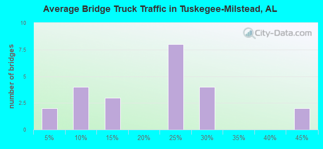
- 1,906Total average daily truck traffic
- 12,840Total future (year 2021) average daily traffic
- National Bridge Inventory (NBI) Registered Bridges for Tuskegee-Milstead
- No street view available for this location
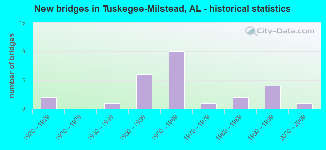
- New bridges - historical statistics
- 21920-1929
- 11940-1949
- 61950-1959
- 101960-1969
- 11970-1979
- 21980-1989
- 41990-1999
- 12000-2009
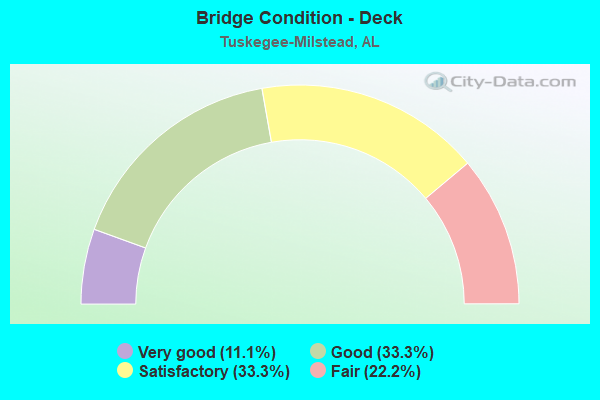
- Bridge Condition - Deck
- 11.1%Very good
- 33.3%Good
- 33.3%Satisfactory
- 22.2%Fair
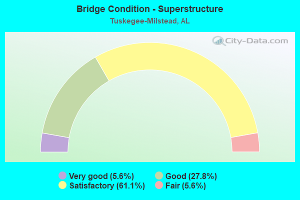
- Bridge Condition - Superstructure
- 5.6%Very good
- 27.8%Good
- 61.1%Satisfactory
- 5.6%Fair
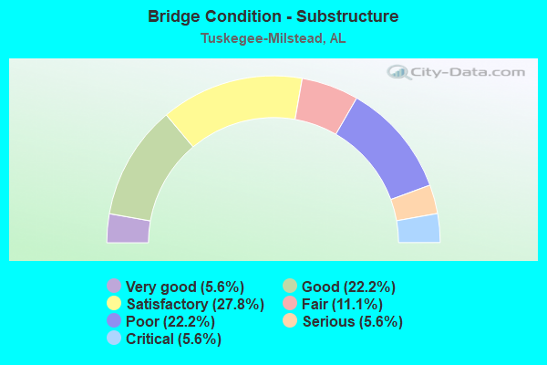
- Bridge Condition - Substructure
- 5.6%Very good
- 22.2%Good
- 27.8%Satisfactory
- 11.1%Fair
- 22.2%Poor
- 5.6%Serious
- 5.6%Critical
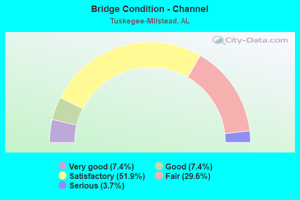
- Bridge Condition - Channel
- 7.4%Very good
- 7.4%Good
- 51.9%Satisfactory
- 29.6%Fair
- 3.7%Serious
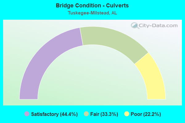
- Bridge Condition - Culverts
- 44.4%Satisfactory
- 33.3%Fair
- 22.2%Poor
Find on map >> Show street view
Structure Number: 534, Location: SE1/4 S18 T16 R23 (Lat: 32.363617, Lng: -85.784650), Route carried "on" structure: County highway 73, Year Built: 1928, Status: Closed, Structure Length: 1.83m (6.00ft), Average Daily Traffic: 100 (year 1990), Average Future Daily Traffic: 100 (year 2021), Design Load: H 10, Features Intersected: CALEBEE CREEK
Minimum Vertical Clearance: 30+ m (98+ ft), Kilometerpoint: 0.010, Lanes on structure: 2, Owner: County Highway Agency, Approaching Roadway Width: 6.1m (20.0ft), Material/Design: Wood or Timber, Design/Construction: Stringer/Multi-beam, Number Of Spans In Main Unit: 4, Length of Maximum Span: 4.9m (16.1ft), Curb-To-Curb Width: 4.6m (15.1ft), Out-to-Out Width: 4.9m (16.1ft)
Condition: Deck: Fair, Superstructure: Fair, Substructure: Poor, Channel: Fair, Waterway Adequacy: Somewhat better than minimum adequacy, Approach Roadway Alignment: Somewhat better than minimum adequacy, Bridge Posting: Required (Relationship of Operating Rating to Maximum Legal Load: > 39.9% below), Length Of Structure Improvement: 2.54m (8.33ft), Designated Inspection Frequency: Every 24 months, Other Special Inspection Frequency: Every 6 months, Inspection Date: Febuary 2003, Other Special Inspection Date: September 2004, Bridge Improvement Cost: $279,000, Roadway Improvement Cost: $28,000, Total Project Cost: $307,000 ( Estimate for 2022), Deck Structure Type: Wood or Timber, Wearing Surface/Protective System: Wearing Surface: Wood or Timber
Find on map >> Show street view
Structure Number: 63, Location: 4.0 MI W OF FAYETTE (Lat: 33.726250, Lng: -87.887400), Route carried "on" structure: State highway 18, Year Built: 1929, Year Reconstructed: 2000, Status: Open, Structure Length: 0.67m (2.20ft), Average Daily Traffic: 2,220 (year 2020), Truck Traffic: 10%, Average Future Daily Traffic: 2,709 (year 2040), Design Load: H 15, Features Intersected: Branch of Luxapillia
Minimum Vertical Clearance: 30+ m (98+ ft), Kilometerpoint: 38.190, Lanes on structure: 2, Owner: State Highway Agency, Approaching Roadway Width: 9.8m (32.2ft), Skew: 3 degrees, Material/Design: Concrete, Design/Construction: Culvert, Number Of Spans In Main Unit: 2, Length of Maximum Span: 3.5m (11.5ft), Curb-To-Curb Width: 7.3m (24.0ft), Out-to-Out Width: 7.3m (24.0ft)
Condition: Channel: Satisfactory, Culverts: Satisfactory, Operating Rating: 87.7 metric tons, Method Used To Determine Operating Rating: Load Factor (LF), Inventory Rating: 52.6 metric tons, Method Used To Determine Inventory Rating: Load Factor (LF), Structural Evaluation: Equal to present minimum criteria, Deck Geometry: High priority of replacement, Waterway Adequacy: Equal to present minimum criteria, Approach Roadway Alignment: Better than present minimum criteria, Length Of Structure Improvement: 1.30m (4.27ft), Designated Inspection Frequency: Every 24 months, Inspection Date: June 2020, Bridge Improvement Cost: $323,000, Roadway Improvement Cost: $32,000, Total Project Cost: $355,000 ( Estimate for 2022)
Find on map >> Show street view
Structure Number: 809, Location: 1.5 MILES NORTH CR22 (Lat: 32.428286, Lng: -85.607381), Route carried "on" structure: County highway 63, Year Built: 1992, Status: Open, Structure Length: 1.31m (4.30ft), Average Daily Traffic: 200 (year 2015), Truck Traffic: 5%, Average Future Daily Traffic: 250 (year 2035), Design Load: HS 20, Features Intersected: UNNAMED BRANCH
Minimum Vertical Clearance: 30+ m (98+ ft), Kilometerpoint: 0.010, Lanes on structure: 2, Owner: County Highway Agency, Approaching Roadway Width: 7.3m (24.0ft), Material/Design: Concrete, Design/Construction: Culvert, Number Of Spans In Main Unit: 4, Length of Maximum Span: 3.0m (9.8ft)
Condition: Channel: Satisfactory, Culverts: Satisfactory, Operating Rating: 88.9 metric tons, Method Used To Determine Operating Rating: Load Factor (LF), Inventory Rating: 53.3 metric tons, Method Used To Determine Inventory Rating: Load Factor (LF), Structural Evaluation: Equal to present minimum criteria, Waterway Adequacy: Better than present minimum criteria, Approach Roadway Alignment: Somewhat better than minimum adequacy, Length Of Structure Improvement: 1.98m (6.50ft), Designated Inspection Frequency: Every 24 months, Inspection Date: December 2020, Bridge Improvement Cost: $470,000, Roadway Improvement Cost: $47,000, Total Project Cost: $517,000 ( Estimate for 2022)
Find on map >> Show street view
Structure Number: 2404, Location: 3.1 MI E.OF SR8/US80E (Lat: 32.357147, Lng: -85.752333), Route carried "on" structure: County highway 67, Year Built: 1940, Status: Closed, Structure Length: 2.09m (6.86ft), Average Daily Traffic: 31 (year 1990), Average Future Daily Traffic: 31 (year 2035), Design Load: H 10, Features Intersected: CALEBEE CREEK
Minimum Vertical Clearance: 30+ m (98+ ft), Kilometerpoint: 0.010, Lanes on structure: 2, Owner: County Highway Agency, Approaching Roadway Width: 4.0m (13.1ft), Material/Design: Wood or Timber, Design/Construction: Stringer/Multi-beam, Number Of Spans In Main Unit: 4, Length of Maximum Span: 5.8m (19.0ft), Curb-To-Curb Width: 4.4m (14.4ft), Out-to-Out Width: 4.4m (14.4ft)
Condition: Deck: Fair, Superstructure: Satisfactory, Substructure: Critical, Channel: Fair, Waterway Adequacy: Somewhat better than minimum adequacy, Approach Roadway Alignment: Meets minimum limits, Bridge Posting: Required (Relationship of Operating Rating to Maximum Legal Load: > 39.9% below), Length Of Structure Improvement: 2.87m (9.42ft), Designated Inspection Frequency: Every 24 months, Other Special Inspection Frequency: Every 3 months, Inspection Date: March 2016, Other Special Inspection Date: March 2016, Bridge Improvement Cost: $275,000, Roadway Improvement Cost: $28,000, Total Project Cost: $303,000 ( Estimate for 2022), Deck Structure Type: Wood or Timber, Wearing Surface/Protective System: Wearing Surface: Wood or Timber
Find on map >> Show street view
Structure Number: 3824, Location: .77 MILES N. CO RD 26 (Lat: 32.400794, Lng: -85.554614), Route carried "on" structure: County highway 71, Year Built: 1991, Status: Open, Structure Length: 2.07m (6.79ft), Average Daily Traffic: 75 (year 2015), Truck Traffic: 5%, Average Future Daily Traffic: 80 (year 2035), Design Load: HS 20, Features Intersected: CHEWACLA CREEK
Minimum Vertical Clearance: 30+ m (98+ ft), Kilometerpoint: 0.010, Lanes on structure: 2, Owner: County Highway Agency, Approaching Roadway Width: 4.3m (14.1ft), Material/Design: Prestressed concrete, Design/Construction: Channel Beam, Number Of Spans In Main Unit: 2, Length of Maximum Span: 10.4m (34.1ft), Curb-To-Curb Width: 6.1m (20.0ft), Out-to-Out Width: 7.5m (24.6ft)
Condition: Deck: Good, Superstructure: Good, Substructure: Good, Channel: Good, Operating Rating: 75.2 metric tons, Method Used To Determine Operating Rating: Load Factor (LF), Inventory Rating: 45.2 metric tons, Method Used To Determine Inventory Rating: Load Factor (LF), Structural Evaluation: Better than present minimum criteria, Deck Geometry: Somewhat better than minimum adequacy, Waterway Adequacy: Better than present minimum criteria, Approach Roadway Alignment: Somewhat better than minimum adequacy, Length Of Structure Improvement: 2.84m (9.32ft), Designated Inspection Frequency: Every 24 months, Inspection Date: March 2021, Bridge Improvement Cost: $468,000, Roadway Improvement Cost: $47,000, Total Project Cost: $515,000 ( Estimate for 2022), Deck Structure Type: Concrete Precast Panels
Find on map >> Show street view
Structure Number: 4076, Location: 1.5 MI. NORTH OF SR 8 (Lat: 32.463481, Lng: -85.657872), Route carried "on" structure: County highway 53, Year Built: 1951, Status: Posted for load, Structure Length: 4.02m (13.19ft), Average Daily Traffic: 400 (year 2016), Truck Traffic: 25%, Average Future Daily Traffic: 450 (year 2036), Design Load: H 15, Features Intersected: CHEWACLA CREEK
Minimum Vertical Clearance: 30+ m (98+ ft), Kilometerpoint: 0.010, Lanes on structure: 2, Owner: County Highway Agency, Approaching Roadway Width: 6.7m (22.0ft), Material/Design: Steel continuous, Design/Construction: Stringer/Multi-beam, Number Of Spans In Main Unit: 3, Length of Maximum Span: 16.2m (53.1ft), Curb-To-Curb Width: 6.6m (21.7ft), Out-to-Out Width: 7.2m (23.6ft)
Condition: Deck: Fair, Superstructure: Good, Substructure: Satisfactory, Channel: Satisfactory, Operating Rating: 35.6 metric tons, Method Used To Determine Operating Rating: Load Factor (LF), Inventory Rating: 21.3 metric tons, Method Used To Determine Inventory Rating: Load Factor (LF), Structural Evaluation: Equal to present minimum criteria, Waterway Adequacy: Equal to present desirable criteria, Approach Roadway Alignment: Equal to present minimum criteria, Bridge Posting: Required (Relationship of Operating Rating to Maximum Legal Load: 0.1 - 9.9% below), Length Of Structure Improvement: 4.97m (16.31ft), Designated Inspection Frequency: Every 24 months, Other Special Inspection Frequency: Every 12 months, Inspection Date: March 2020, Other Special Inspection Date: March 2021, Bridge Improvement Cost: $784,000, Roadway Improvement Cost: $78,000, Total Project Cost: $862,000 ( Estimate for 2022), Deck Structure Type: Concrete Cast-file-Place
Find on map >> Show street view
Structure Number: 5181, Location: 0.3 MI WEST SR49 (Lat: 32.469167, Lng: -85.812531), Route carried "on" structure: County highway 17, Year Built: 1992, Status: Open, Structure Length: 3.11m (10.20ft), Average Daily Traffic: 220 (year 2015), Truck Traffic: 20%, Average Future Daily Traffic: 300 (year 2035), Design Load: HS 20, Features Intersected: UNNAMED BRANCH
Minimum Vertical Clearance: 30+ m (98+ ft), Kilometerpoint: 0.010, Lanes on structure: 2, Owner: County Highway Agency, Approaching Roadway Width: 8.5m (27.9ft), Material/Design: Prestressed concrete, Design/Construction: Stringer/Multi-beam, Number Of Spans In Main Unit: 3, Length of Maximum Span: 10.4m (34.1ft), Curb-To-Curb Width: 6.5m (21.3ft), Out-to-Out Width: 8.2m (26.9ft)
Condition: Deck: Good, Superstructure: Good, Substructure: Good, Channel: Satisfactory, Operating Rating: 67.0 metric tons, Method Used To Determine Operating Rating: Load Factor (LF), Inventory Rating: 40.1 metric tons, Method Used To Determine Inventory Rating: Load Factor (LF), Structural Evaluation: Better than present minimum criteria, Deck Geometry: Meets minimum limits, Waterway Adequacy: Equal to present desirable criteria, Approach Roadway Alignment: Equal to present minimum criteria, Length Of Structure Improvement: 3.96m (12.99ft), Designated Inspection Frequency: Every 24 months, Inspection Date: December 2020, Bridge Improvement Cost: $706,000, Roadway Improvement Cost: $71,000, Total Project Cost: $777,000 ( Estimate for 2022), Deck Structure Type: Concrete Precast Panels
Find on map >> Show street view
Structure Number: 5957, Location: 6.4 MI. W. OF CO RD 8 (Lat: 32.490269, Lng: -85.815050), Route carried "on" structure: County highway 56, Year Built: 1957, Status: Posted for load, Structure Length: 0.91m (2.99ft), Average Daily Traffic: 587 (year 2016), Truck Traffic: 40%, Average Future Daily Traffic: 700 (year 2036), Design Load: H 15, Features Intersected: GLEEDEN BRANCH
Minimum Vertical Clearance: 30+ m (98+ ft), Kilometerpoint: 0.010, Lanes on structure: 2, Owner: County Highway Agency, Approaching Roadway Width: 6.4m (21.0ft), Skew: 4 degrees, Material/Design: Concrete, Design/Construction: Culvert, Number Of Spans In Main Unit: 2, Length of Maximum Span: 3.0m (9.8ft), Out-to-Out Width: 10.3m (33.8ft)
Condition: Channel: Fair, Culverts: Poor, Operating Rating: 19.7 metric tons, Method Used To Determine Operating Rating: Load Factor (LF), Inventory Rating: 11.8 metric tons, Method Used To Determine Inventory Rating: Load Factor (LF), Structural Evaluation: High priority of replacement, Waterway Adequacy: Better than present minimum criteria, Approach Roadway Alignment: Better than present minimum criteria, Bridge Posting: Required (Relationship of Operating Rating to Maximum Legal Load: > 39.9% below), Length Of Structure Improvement: 1.59m (5.22ft), Designated Inspection Frequency: Every 24 months, Other Special Inspection Frequency: Every 12 months, Inspection Date: March 2021, Other Special Inspection Date: March 2021, Bridge Improvement Cost: $458,000, Roadway Improvement Cost: $46,000, Total Project Cost: $504,000 ( Estimate for 2018)
Find on map >> Show street view
Structure Number: 5975, Location: 2.2 Miles West CO RD 45 (Lat: 32.348017, Lng: -85.732594), Route carried "on" structure: County highway 67, Year Built: 1957, Status: Closed, Structure Length: 1.80m (5.91ft), Average Daily Traffic: 35 (year 2015), Average Future Daily Traffic: 35 (year 2035), Design Load: H 10, Features Intersected: CALEBEE CREEK
Minimum Vertical Clearance: 30+ m (98+ ft), Kilometerpoint: 0.010, Lanes on structure: 2, Owner: County Highway Agency, Approaching Roadway Width: 6.1m (20.0ft), Material/Design: Wood or Timber, Design/Construction: Stringer/Multi-beam, Number Of Spans In Main Unit: 4, Length of Maximum Span: 4.6m (15.1ft), Curb-To-Curb Width: 4.3m (14.1ft), Out-to-Out Width: 5.0m (16.4ft)
Condition: Deck: Good, Superstructure: Satisfactory, Substructure: Good, Channel: Satisfactory, Waterway Adequacy: Better than present minimum criteria, Approach Roadway Alignment: Meets minimum limits, Bridge Posting: Required (Relationship of Operating Rating to Maximum Legal Load: > 39.9% below), Length Of Structure Improvement: 2.51m (8.23ft), Designated Inspection Frequency: Every 24 months, Other Special Inspection Frequency: Every 3 months, Inspection Date: January 2015, Other Special Inspection Date: December 2015, Bridge Improvement Cost: $275,000, Roadway Improvement Cost: $28,000, Total Project Cost: $303,000 ( Estimate for 2022), Deck Structure Type: Wood or Timber, Wearing Surface/Protective System: Wearing Surface: Wood or Timber
Find on map >> Show street view
Structure Number: 6299, Location: W1/2 S36 T16 R23 (Lat: 32.330181, Lng: -85.693347), Route carried "on" structure: County highway 45, Year Built: 1958, Status: Closed, Structure Length: 11.58m (37.99ft), Average Daily Traffic: 160 (year 1990), Truck Traffic: 20%, Average Future Daily Traffic: 180 (year 2021), Design Load: H 15, Features Intersected: CALEBEE CREEK
Minimum Vertical Clearance: 30+ m (98+ ft), Kilometerpoint: 0.010, Lanes on structure: 2, Owner: County Highway Agency, Approaching Roadway Width: 8.5m (27.9ft), Material/Design: Concrete, Design/Construction: Slab, Number Of Spans In Main Unit: 20, Length of Maximum Span: 5.8m (19.0ft), Curb-To-Curb Width: 6.7m (22.0ft), Out-to-Out Width: 7.2m (23.6ft)
Condition: Deck: Fair, Superstructure: Satisfactory, Substructure: Serious, Channel: Fair, Waterway Adequacy: Better than present minimum criteria, Approach Roadway Alignment: Somewhat better than minimum adequacy, Bridge Posting: Required (Relationship of Operating Rating to Maximum Legal Load: > 39.9% below), Length Of Structure Improvement: 12.45m (40.85ft), Designated Inspection Frequency: Every 24 months, Other Special Inspection Frequency: Every 3 months, Inspection Date: Febuary 2003, Other Special Inspection Date: September 2004, Bridge Improvement Cost: $1,963,000, Roadway Improvement Cost: $196,000, Total Project Cost: $2,159,000 ( Estimate for 2022), Deck Structure Type: Concrete Precast Panels
Find on map >> Show street view
Structure Number: 63, Location: NE1/4 S36 T16 R23 (Lat: 32.332039, Lng: -85.693331), Route carried "on" structure: County highway 45, Year Built: 1958, Status: Closed, Structure Length: 1.74m (5.71ft), Average Daily Traffic: 160 (year 1990), Truck Traffic: 20%, Average Future Daily Traffic: 180 (year 2021), Design Load: H 15, Features Intersected: CALEBEE CREEK RELIEF
Minimum Vertical Clearance: 30+ m (98+ ft), Kilometerpoint: 0.010, Lanes on structure: 2, Owner: County Highway Agency, Approaching Roadway Width: 8.5m (27.9ft), Material/Design: Concrete, Design/Construction: Channel Beam, Number Of Spans In Main Unit: 3, Length of Maximum Span: 5.8m (19.0ft), Curb-To-Curb Width: 6.7m (22.0ft), Out-to-Out Width: 7.2m (23.6ft)
Condition: Deck: Satisfactory, Superstructure: Satisfactory, Substructure: Poor, Channel: Satisfactory, Waterway Adequacy: Equal to present minimum criteria, Approach Roadway Alignment: Somewhat better than minimum adequacy, Bridge Posting: Required (Relationship of Operating Rating to Maximum Legal Load: > 39.9% below), Length Of Structure Improvement: 2.44m (8.01ft), Designated Inspection Frequency: Every 24 months, Other Special Inspection Frequency: Every 3 months, Inspection Date: Febuary 2003, Other Special Inspection Date: June 2004, Bridge Improvement Cost: $385,000, Roadway Improvement Cost: $39,000, Total Project Cost: $424,000 ( Estimate for 2022), Deck Structure Type: Concrete Precast Panels
Find on map >> Show street view
Structure Number: 6638, Location: 0.5 Miles E. HWY49S/CR27 (Lat: 32.489589, Lng: -85.789331), Route carried "on" structure: County highway 56, Year Built: 1959, Status: Posted for load, Structure Length: 4.65m (15.26ft), Average Daily Traffic: 587 (year 2016), Truck Traffic: 40%, Average Future Daily Traffic: 600 (year 2036), Design Load: H 15, Features Intersected: WAUXAMAKA CREEK
Minimum Vertical Clearance: 30+ m (98+ ft), Kilometerpoint: 0.010, Lanes on structure: 2, Owner: County Highway Agency, Approaching Roadway Width: 5.9m (19.4ft), Material/Design: Concrete, Design/Construction: Tee Beam, Number Of Spans In Main Unit: 4, Length of Maximum Span: 12.2m (40.0ft), Curb-To-Curb Width: 6.7m (22.0ft), Out-to-Out Width: 7.1m (23.3ft)
Condition: Deck: Good, Superstructure: Satisfactory, Substructure: Satisfactory, Channel: Satisfactory, Operating Rating: 36.7 metric tons, Method Used To Determine Operating Rating: Load Factor (LF), Inventory Rating: 20.8 metric tons, Method Used To Determine Inventory Rating: Load Factor (LF), Structural Evaluation: Somewhat better than minimum adequacy, Deck Geometry: Meets minimum limits, Waterway Adequacy: Equal to present desirable criteria, Approach Roadway Alignment: Somewhat better than minimum adequacy, Bridge Posting: Required (Relationship of Operating Rating to Maximum Legal Load: 10.0 - 19.9% below), Length Of Structure Improvement: 5.65m (18.54ft), Designated Inspection Frequency: Every 24 months, Other Special Inspection Frequency: Every 12 months, Inspection Date: Febuary 2021, Other Special Inspection Date: Febuary 2022, Bridge Improvement Cost: $891,000, Roadway Improvement Cost: $89,000, Total Project Cost: $980,000 ( Estimate for 2022), Deck Structure Type: Concrete Cast-file-Place
Find on map >> Show street view
Structure Number: 7384, Location: 4.9 MI SOUTHWEST SR8 (Lat: 32.414600, Lng: -85.628922), Route carried "on" structure: County highway 26, Year Built: 1961, Status: Open, Structure Length: 0.64m (2.10ft), Average Daily Traffic: 535 (year 2015), Truck Traffic: 25%, Average Future Daily Traffic: 700 (year 2035), Design Load: H 15, Features Intersected: UNNAMED BRANCH
Minimum Vertical Clearance: 30+ m (98+ ft), Kilometerpoint: 0.010, Lanes on structure: 2, Owner: County Highway Agency, Approaching Roadway Width: 6.4m (21.0ft), Material/Design: Concrete, Design/Construction: Culvert, Number Of Spans In Main Unit: 2, Length of Maximum Span: 3.0m (9.8ft)
Condition: Channel: Satisfactory, Culverts: Fair, Operating Rating: 39.9 metric tons, Method Used To Determine Operating Rating: Load Factor (LF), Inventory Rating: 23.9 metric tons, Method Used To Determine Inventory Rating: Load Factor (LF), Structural Evaluation: Somewhat better than minimum adequacy, Waterway Adequacy: Equal to present minimum criteria, Approach Roadway Alignment: Equal to present minimum criteria, Length Of Structure Improvement: 1.26m (4.13ft), Designated Inspection Frequency: Every 24 months, Inspection Date: Febuary 2021, Bridge Improvement Cost: $247,000, Roadway Improvement Cost: $25,000, Total Project Cost: $272,000 ( Estimate for 2022), Wearing Surface/Protective System: Wearing Surface: Bituminous
Find on map >> Show street view
Structure Number: 7385, Location: 4.9 MI EAST MLK HWY (Lat: 32.412389, Lng: -85.616456), Route carried "on" structure: County highway 26, Year Built: 1961, Status: Posted for load, Structure Length: 9.20m (30.18ft), Average Daily Traffic: 535 (year 2016), Truck Traffic: 25%, Average Future Daily Traffic: 600 (year 2036), Design Load: H 15, Features Intersected: OPINTLOCCO CREEK
Minimum Vertical Clearance: 30+ m (98+ ft), Kilometerpoint: 0.010, Lanes on structure: 2, Owner: County Highway Agency, Approaching Roadway Width: 6.7m (22.0ft), Material/Design: Concrete, Design/Construction: Tee Beam, Number Of Spans In Main Unit: 15, Length of Maximum Span: 12.2m (40.0ft), Curb-To-Curb Width: 6.7m (22.0ft), Out-to-Out Width: 7.1m (23.3ft)
Condition: Deck: Good, Superstructure: Satisfactory, Substructure: Poor, Channel: Satisfactory, Operating Rating: 11.8 metric tons, Method Used To Determine Operating Rating: Load Factor (LF), Inventory Rating: 10.0 metric tons, Method Used To Determine Inventory Rating: Load Factor (LF), Structural Evaluation: High priority of replacement, Deck Geometry: Meets minimum limits, Waterway Adequacy: Equal to present desirable criteria, Approach Roadway Alignment: Better than present minimum criteria, Bridge Posting: Required (Relationship of Operating Rating to Maximum Legal Load: > 39.9% below), Length Of Structure Improvement: 10.16m (33.33ft), Designated Inspection Frequency: Every 24 months, Other Special Inspection Frequency: Every 12 months, Inspection Date: Febuary 2021, Other Special Inspection Date: Febuary 2022, Bridge Improvement Cost: $1,603,000, Roadway Improvement Cost: $160,000, Total Project Cost: $1,763,000 ( Estimate for 2022), Deck Structure Type: Concrete Precast Panels
Find on map >> Show street view
Structure Number: 7386, Location: 4.8 MI EAST OF MLK HWY (Lat: 32.412086, Lng: -85.615142), Route carried "on" structure: County highway 26, Year Built: 1961, Status: Posted for load, Structure Length: 1.74m (5.71ft), Average Daily Traffic: 535 (year 2016), Truck Traffic: 10%, Average Future Daily Traffic: 590 (year 2036), Design Load: H 15, Features Intersected: OPINTLOCCO CREEK
Minimum Vertical Clearance: 30+ m (98+ ft), Kilometerpoint: 0.010, Lanes on structure: 2, Owner: County Highway Agency, Approaching Roadway Width: 6.7m (22.0ft), Material/Design: Concrete, Design/Construction: Channel Beam, Number Of Spans In Main Unit: 3, Length of Maximum Span: 5.8m (19.0ft), Curb-To-Curb Width: 6.7m (22.0ft), Out-to-Out Width: 7.1m (23.3ft)
Condition: Deck: Satisfactory, Superstructure: Satisfactory, Substructure: Fair, Channel: Very good, Operating Rating: 36.3 metric tons, Method Used To Determine Operating Rating: Load Factor (LF), Inventory Rating: 21.8 metric tons, Method Used To Determine Inventory Rating: Load Factor (LF), Structural Evaluation: Somewhat better than minimum adequacy, Deck Geometry: Meets minimum limits, Waterway Adequacy: Equal to present desirable criteria, Approach Roadway Alignment: Better than present minimum criteria, Bridge Posting: Required (Relationship of Operating Rating to Maximum Legal Load: 10.0 - 19.9% below), Length Of Structure Improvement: 2.44m (8.01ft), Designated Inspection Frequency: Every 24 months, Other Special Inspection Frequency: Every 12 months, Inspection Date: Febuary 2021, Other Special Inspection Date: Febuary 2022, Bridge Improvement Cost: $384,000, Roadway Improvement Cost: $38,000, Total Project Cost: $422,000 ( Estimate for 2022), Deck Structure Type: Concrete Precast Panels
Find on map >> Show street view
Structure Number: 7387, Location: 4.7 MI EAST W-MLK HWY (Lat: 32.411222, Lng: -85.611583), Route carried "on" structure: County highway 26, Year Built: 1961, Status: Posted for load, Structure Length: 5.21m (17.09ft), Average Daily Traffic: 536 (year 2016), Truck Traffic: 10%, Average Future Daily Traffic: 590 (year 2036), Design Load: H 15, Features Intersected: OPINTLOCCO CREEK RELIEF
Minimum Vertical Clearance: 30+ m (98+ ft), Kilometerpoint: 0.010, Lanes on structure: 2, Owner: County Highway Agency, Approaching Roadway Width: 6.7m (22.0ft), Material/Design: Concrete, Design/Construction: Channel Beam, Number Of Spans In Main Unit: 9, Length of Maximum Span: 5.8m (19.0ft), Curb-To-Curb Width: 6.7m (22.0ft), Out-to-Out Width: 7.1m (23.3ft)
Condition: Deck: Satisfactory, Superstructure: Satisfactory, Substructure: Poor, Channel: Satisfactory, Operating Rating: 9.1 metric tons, Method Used To Determine Operating Rating: Load Factor (LF), Inventory Rating: 6.4 metric tons, Method Used To Determine Inventory Rating: Load Factor (LF), Structural Evaluation: High priority of replacement, Deck Geometry: Meets minimum limits, Waterway Adequacy: Better than present minimum criteria, Approach Roadway Alignment: Equal to present minimum criteria, Bridge Posting: Required (Relationship of Operating Rating to Maximum Legal Load: > 39.9% below), Length Of Structure Improvement: 6.23m (20.44ft), Designated Inspection Frequency: Every 24 months, Other Special Inspection Frequency: Every 12 months, Inspection Date: Febuary 2021, Other Special Inspection Date: Febuary 2022, Bridge Improvement Cost: $983,000, Roadway Improvement Cost: $98,000, Total Project Cost: $1,081,000 ( Estimate for 2022), Deck Structure Type: Concrete Precast Panels
Find on map >> Show street view
Structure Number: 7685, Location: 6.6 MI. WEST-WMLK HWY (Lat: 32.412750, Lng: -85.586617), Route carried "on" structure: County highway 22, Year Built: 1962, Status: Posted for load, Structure Length: 3.11m (10.20ft), Average Daily Traffic: 325 (year 2016), Truck Traffic: 20%, Average Future Daily Traffic: 350 (year 2036), Design Load: H 15, Features Intersected: CAMPGROUND BRANCH
Minimum Vertical Clearance: 30+ m (98+ ft), Kilometerpoint: 0.010, Lanes on structure: 2, Owner: County Highway Agency, Approaching Roadway Width: 6.7m (22.0ft), Skew: 3 degrees, Material/Design: Concrete continuous, Design/Construction: Tee Beam, Number Of Spans In Main Unit: 3, Length of Maximum Span: 10.4m (34.1ft), Curb-To-Curb Width: 6.7m (22.0ft), Out-to-Out Width: 7.1m (23.3ft)
Condition: Deck: Good, Superstructure: Good, Substructure: Satisfactory, Channel: Fair, Operating Rating: 41.7 metric tons, Method Used To Determine Operating Rating: Load Factor (LF), Inventory Rating: 24.5 metric tons, Method Used To Determine Inventory Rating: Load Factor (LF), Structural Evaluation: Equal to present minimum criteria, Deck Geometry: Meets minimum limits, Waterway Adequacy: Better than present minimum criteria, Approach Roadway Alignment: Equal to present minimum criteria, Bridge Posting: Required (Relationship of Operating Rating to Maximum Legal Load: 0.1 - 9.9% below), Length Of Structure Improvement: 3.96m (12.99ft), Designated Inspection Frequency: Every 24 months, Other Special Inspection Frequency: Every 12 months, Inspection Date: Febuary 2021, Other Special Inspection Date: Febuary 2022, Bridge Improvement Cost: $625,000, Roadway Improvement Cost: $63,000, Total Project Cost: $688,000 ( Estimate for 2019), Deck Structure Type: Concrete Cast-file-Place
Find on map >> Show street view
Structure Number: 8263, Location: 2.3 MI EAST OF SR229 (Lat: 32.447053, Lng: -85.869517), Route carried "on" structure: County highway 9, Year Built: 1964, Status: Posted for load, Structure Length: 4.75m (15.58ft), Average Daily Traffic: 268 (year 2016), Truck Traffic: 5%, Average Future Daily Traffic: 320 (year 2036), Design Load: H 15, Features Intersected: WALKER BRANCH
Minimum Vertical Clearance: 30+ m (98+ ft), Kilometerpoint: 0.010, Lanes on structure: 2, Owner: County Highway Agency, Approaching Roadway Width: 8.5m (27.9ft), Material/Design: Concrete, Design/Construction: Culvert, Number Of Spans In Main Unit: 2, Length of Maximum Span: 3.7m (12.1ft), Curb-To-Curb Width: 16.7m (54.8ft), Out-to-Out Width: 16.7m (54.8ft)
Condition: Channel: Fair, Culverts: Poor, Operating Rating: 9.1 metric tons, Method Used To Determine Operating Rating: Load Factor (LF), Inventory Rating: 6.4 metric tons, Method Used To Determine Inventory Rating: Load Factor (LF), Structural Evaluation: High priority of replacement, Waterway Adequacy: Better than present minimum criteria, Approach Roadway Alignment: Somewhat better than minimum adequacy, Bridge Posting: Required (Relationship of Operating Rating to Maximum Legal Load: > 39.9% below), Length Of Structure Improvement: 5.75m (18.86ft), Designated Inspection Frequency: Every 24 months, Other Special Inspection Frequency: Every 12 months, Inspection Date: January 2022, Other Special Inspection Date: January 2022, Bridge Improvement Cost: $1,861,000, Roadway Improvement Cost: $186,000, Total Project Cost: $2,047,000 ( Estimate for 2022), Wearing Surface/Protective System: Wearing Surface: Gravel
Find on map >> Show street view
Structure Number: 8307, Location: 0.9 MI. N, US80N/SR8 (Lat: 32.394781, Lng: -85.829467), Route carried "on" structure: County highway 29, Year Built: 1964, Status: Posted for load, Structure Length: 2.90m (9.51ft), Average Daily Traffic: 160 (year 2016), Truck Traffic: 1%, Average Future Daily Traffic: 175 (year 2036), Design Load: H 15, Features Intersected: HOG BRANCH
Minimum Vertical Clearance: 30+ m (98+ ft), Kilometerpoint: 0.010, Lanes on structure: 2, Owner: County Highway Agency, Approaching Roadway Width: 6.1m (20.0ft), Material/Design: Concrete, Design/Construction: Channel Beam, Number Of Spans In Main Unit: 5, Length of Maximum Span: 5.8m (19.0ft), Curb-To-Curb Width: 7.3m (24.0ft), Out-to-Out Width: 7.6m (24.9ft)
Condition: Deck: Satisfactory, Superstructure: Satisfactory, Substructure: Fair, Channel: Serious, Operating Rating: 13.6 metric tons, Method Used To Determine Operating Rating: Load Factor (LF), Inventory Rating: 9.1 metric tons, Method Used To Determine Inventory Rating: Load Factor (LF), Structural Evaluation: High priority of corrective action, Deck Geometry: Somewhat better than minimum adequacy, Waterway Adequacy: Better than present minimum criteria, Approach Roadway Alignment: Equal to present minimum criteria, Bridge Posting: Required (Relationship of Operating Rating to Maximum Legal Load: > 39.9% below), Length Of Structure Improvement: 3.81m (12.50ft), Designated Inspection Frequency: Every 24 months, Other Special Inspection Frequency: Every 3 months, Inspection Date: Febuary 2021, Other Special Inspection Date: Febuary 2022, Bridge Improvement Cost: $627,000, Roadway Improvement Cost: $63,000, Total Project Cost: $690,000 ( Estimate for 2022), Deck Structure Type: Concrete Precast Panels
Find on map >> Show street view
Structure Number: 9384, Location: 0.4 MI. NO. US80W/SR8 (Lat: 32.408189, Lng: -85.734081), Route carried "on" structure: County highway 51, Year Built: 1967, Status: Open, Structure Length: 1.58m (5.18ft), Average Daily Traffic: 600 (year 2015), Truck Traffic: 20%, Average Future Daily Traffic: 800 (year 2035), Design Load: H 15, Features Intersected: UNNAMED BRANCH
Minimum Vertical Clearance: 30+ m (98+ ft), Kilometerpoint: 0.010, Lanes on structure: 2, Owner: County Highway Agency, Approaching Roadway Width: 14.0m (45.9ft), Material/Design: Concrete, Design/Construction: Culvert, Number Of Spans In Main Unit: 4, Length of Maximum Span: 3.7m (12.1ft), Curb-To-Curb Width: 8.5m (27.9ft), Out-to-Out Width: 8.5m (27.9ft)
Condition: Channel: Satisfactory, Culverts: Fair, Operating Rating: 88.9 metric tons, Method Used To Determine Operating Rating: Load Factor (LF), Inventory Rating: 88.9 metric tons, Method Used To Determine Inventory Rating: Load Factor (LF), Structural Evaluation: Somewhat better than minimum adequacy, Deck Geometry: Somewhat better than minimum adequacy, Waterway Adequacy: Better than present minimum criteria, Approach Roadway Alignment: Equal to present desirable criteria, Length Of Structure Improvement: 2.26m (7.41ft), Designated Inspection Frequency: Every 24 months, Inspection Date: Febuary 2021, Bridge Improvement Cost: $1,410,000, Roadway Improvement Cost: $141,000, Total Project Cost: $1,551,000 ( Estimate for 2022), Wearing Surface/Protective System: Wearing Surface: Bituminous
Find on map >> Show street view
Structure Number: 9385, Location: 1.0 MILE NO. HWY80W/SR8 (Lat: 32.413186, Lng: -85.742947), Route carried "on" structure: County highway 51, Year Built: 1967, Status: Open, Structure Length: 1.16m (3.81ft), Average Daily Traffic: 600 (year 2015), Truck Traffic: 20%, Average Future Daily Traffic: 800 (year 2035), Design Load: H 15, Features Intersected: UNNAMED BRANCH
Minimum Vertical Clearance: 30+ m (98+ ft), Kilometerpoint: 0.010, Lanes on structure: 2, Owner: County Highway Agency, Approaching Roadway Width: 7.3m (24.0ft), Material/Design: Concrete, Design/Construction: Culvert, Number Of Spans In Main Unit: 3, Length of Maximum Span: 3.7m (12.1ft), Out-to-Out Width: 14.0m (45.9ft)
Condition: Channel: Fair, Culverts: Satisfactory, Operating Rating: 88.9 metric tons, Method Used To Determine Operating Rating: Load Factor (LF), Inventory Rating: 88.9 metric tons, Method Used To Determine Inventory Rating: Load Factor (LF), Structural Evaluation: Equal to present minimum criteria, Waterway Adequacy: Equal to present minimum criteria, Approach Roadway Alignment: Equal to present desirable criteria, Length Of Structure Improvement: 1.84m (6.04ft), Designated Inspection Frequency: Every 24 months, Inspection Date: Febuary 2021, Bridge Improvement Cost: $1,177,000, Roadway Improvement Cost: $118,000, Total Project Cost: $1,295,000 ( Estimate for 2022), Wearing Surface/Protective System: Wearing Surface: Bituminous
Find on map >> Show street view
Structure Number: 9386, Location: 3 Miles South I-85 (Lat: 32.419847, Lng: -85.754606), Route carried "on" structure: County highway 51, Year Built: 1967, Status: Open, Structure Length: 0.73m (2.40ft), Average Daily Traffic: 600 (year 2015), Truck Traffic: 20%, Average Future Daily Traffic: 700 (year 2035), Design Load: H 15, Features Intersected: UNNAMED BRANCH
Minimum Vertical Clearance: 30+ m (98+ ft), Kilometerpoint: 0.010, Lanes on structure: 2, Owner: County Highway Agency, Approaching Roadway Width: 7.3m (24.0ft), Material/Design: Concrete, Design/Construction: Culvert, Number Of Spans In Main Unit: 2, Length of Maximum Span: 3.7m (12.1ft), Out-to-Out Width: 28.0m (91.9ft)
Condition: Channel: Satisfactory, Culverts: Fair, Operating Rating: 88.9 metric tons, Method Used To Determine Operating Rating: Load Factor (LF), Inventory Rating: 88.9 metric tons, Method Used To Determine Inventory Rating: Load Factor (LF), Structural Evaluation: Somewhat better than minimum adequacy, Waterway Adequacy: Better than present minimum criteria, Approach Roadway Alignment: Equal to present desirable criteria, Length Of Structure Improvement: 1.38m (4.53ft), Designated Inspection Frequency: Every 24 months, Inspection Date: Febuary 2021, Bridge Improvement Cost: $731,000, Roadway Improvement Cost: $73,000, Total Project Cost: $804,000 ( Estimate for 2022), Wearing Surface/Protective System: Wearing Surface: Bituminous
Find on map >> Show street view
Structure Number: 10977, Location: 0.14 MI SO WIRE RD (Lat: 32.451408, Lng: -85.654453), Route carried "on" structure: County highway 53, Year Built: 1973, Status: Open, Structure Length: 5.18m (16.99ft), Average Daily Traffic: 400 (year 2016), Truck Traffic: 25%, Average Future Daily Traffic: 450 (year 2036), Design Load: H 15, Features Intersected: UPHAPEE CREEK
Minimum Vertical Clearance: 30+ m (98+ ft), Kilometerpoint: 0.010, Lanes on structure: 2, Owner: County Highway Agency, Approaching Roadway Width: 6.7m (22.0ft), Material/Design: Concrete, Design/Construction: Channel Beam, Number Of Spans In Main Unit: 5, Length of Maximum Span: 10.4m (34.1ft), Curb-To-Curb Width: 7.4m (24.3ft), Out-to-Out Width: 8.0m (26.2ft)
Condition: Deck: Satisfactory, Superstructure: Satisfactory, Substructure: Satisfactory, Channel: Satisfactory, Operating Rating: 53.7 metric tons, Method Used To Determine Operating Rating: Load Factor (LF), Inventory Rating: 32.2 metric tons, Method Used To Determine Inventory Rating: Load Factor (LF), Structural Evaluation: Equal to present minimum criteria, Deck Geometry: Somewhat better than minimum adequacy, Waterway Adequacy: Superior to present desirable criteria, Approach Roadway Alignment: Better than present minimum criteria, Length Of Structure Improvement: 6.21m (20.37ft), Designated Inspection Frequency: Every 24 months, Inspection Date: March 2020, Bridge Improvement Cost: $1,106,000, Roadway Improvement Cost: $111,000, Total Project Cost: $1,217,000 ( Estimate for 2022), Deck Structure Type: Concrete Precast Panels
Find on map >> Show street view
Structure Number: 12407, Location: 0.43 MI NO HWY80W/SR8 (Lat: 32.389833, Lng: -85.766075), Route carried "on" structure: County highway 81, Year Built: 1980, Status: Open, Structure Length: 2.93m (9.61ft), Average Daily Traffic: 110 (year 2015), Truck Traffic: 2%, Average Future Daily Traffic: 125 (year 2035), Design Load: H 15, Features Intersected: LITTLE CALEBEE CREEK
Minimum Vertical Clearance: 30+ m (98+ ft), Kilometerpoint: 0.010, Lanes on structure: 2, Owner: County Highway Agency, Approaching Roadway Width: 6.7m (22.0ft), Material/Design: Concrete, Design/Construction: Channel Beam, Number Of Spans In Main Unit: 3, Length of Maximum Span: 7.3m (24.0ft), Curb-To-Curb Width: 7.3m (24.0ft), Out-to-Out Width: 7.4m (24.3ft)
Condition: Deck: Satisfactory, Superstructure: Satisfactory, Substructure: Satisfactory, Channel: Satisfactory, Operating Rating: 53.5 metric tons, Method Used To Determine Operating Rating: Load Factor (LF), Inventory Rating: 31.8 metric tons, Method Used To Determine Inventory Rating: Load Factor (LF), Structural Evaluation: Equal to present minimum criteria, Waterway Adequacy: Equal to present minimum criteria, Approach Roadway Alignment: Equal to present minimum criteria, Length Of Structure Improvement: 3.83m (12.57ft), Designated Inspection Frequency: Every 24 months, Inspection Date: March 2021, Bridge Improvement Cost: $631,000, Roadway Improvement Cost: $63,000, Total Project Cost: $694,000 ( Estimate for 2022), Deck Structure Type: Concrete Precast Panels
Find on map >> Show street view
Structure Number: 13943, Location: 2.5 MILES SO. SR 56 (Lat: 32.475900, Lng: -85.780892), Route carried "on" structure: County highway 36, Year Built: 1986, Status: Open, Structure Length: 1.19m (3.90ft), Average Daily Traffic: 385 (year 2015), Truck Traffic: 20%, Average Future Daily Traffic: 500 (year 2035), Design Load: HS 20, Features Intersected: COOPER CREEK
Minimum Vertical Clearance: 30+ m (98+ ft), Kilometerpoint: 0.010, Lanes on structure: 2, Owner: County Highway Agency, Approaching Roadway Width: 6.6m (21.7ft), Material/Design: Concrete, Design/Construction: Culvert, Number Of Spans In Main Unit: 3, Length of Maximum Span: 3.7m (12.1ft)
Condition: Channel: Good, Culverts: Satisfactory, Operating Rating: 88.8 metric tons, Method Used To Determine Operating Rating: Load Factor (LF), Inventory Rating: 53.3 metric tons, Method Used To Determine Inventory Rating: Load Factor (LF), Structural Evaluation: Equal to present minimum criteria, Waterway Adequacy: Better than present minimum criteria, Approach Roadway Alignment: Better than present minimum criteria, Length Of Structure Improvement: 1.86m (6.10ft), Designated Inspection Frequency: Every 24 months, Inspection Date: March 2021, Bridge Improvement Cost: $505,000, Roadway Improvement Cost: $51,000, Total Project Cost: $556,000 ( Estimate for 2022)
Find on map >> Show street view
Structure Number: 19295, Location: S1/2 S36 T17 R24 (Lat: 32.415828, Lng: -85.599394), Route carried "on" structure: County highway 63, Year Built: 1991, Status: Closed, Structure Length: 3.11m (10.20ft), Average Daily Traffic: 115 (year 2005), Truck Traffic: 5%, Average Future Daily Traffic: 150 (year 2030), Design Load: HS 20, Features Intersected: CHEWACLA CREEK
Minimum Vertical Clearance: 30+ m (98+ ft), Kilometerpoint: 0.010, Lanes on structure: 2, Owner: County Highway Agency, Approaching Roadway Width: 6.1m (20.0ft), Material/Design: Concrete, Design/Construction: Channel Beam, Number Of Spans In Main Unit: 3, Length of Maximum Span: 10.4m (34.1ft), Curb-To-Curb Width: 6.5m (21.3ft), Out-to-Out Width: 7.3m (24.0ft)
Condition: Deck: Very good, Superstructure: Good, Substructure: Good, Channel: Fair, Deck Geometry: Meets minimum limits, Waterway Adequacy: Better than present minimum criteria, Approach Roadway Alignment: Meets minimum limits, Bridge Posting: Required (Relationship of Operating Rating to Maximum Legal Load: > 39.9% below), Length Of Structure Improvement: 3.96m (12.99ft), Designated Inspection Frequency: Every 24 months, Inspection Date: June 2020, Bridge Improvement Cost: $652,000, Roadway Improvement Cost: $65,000, Total Project Cost: $717,000 ( Estimate for 2022), Deck Structure Type: Concrete Precast Panels
Find on map >> Show street view
Structure Number: 19574, Location: 0.14 MI NO OF CO RD 67 (Lat: 32.357597, Lng: -85.700219), Route carried "on" structure: County highway 45, Year Built: 2006, Status: Open, Structure Length: 8.53m (27.99ft), Average Daily Traffic: 341 (year 2016), Average Future Daily Traffic: 375 (year 2036), Design Load: HS 20, Features Intersected: PERSIMMON CREEK
Minimum Vertical Clearance: 30+ m (98+ ft), Kilometerpoint: 0.000, Lanes on structure: 2, Owner: County Highway Agency, Approaching Roadway Width: 6.7m (22.0ft), Skew: 3 degrees, Material/Design: Concrete, Design/Construction: Channel Beam, Number Of Spans In Main Unit: 7, Length of Maximum Span: 12.2m (40.0ft), Curb-To-Curb Width: 8.5m (27.9ft), Out-to-Out Width: 9.3m (30.5ft)
Condition: Deck: Very good, Superstructure: Very good, Substructure: Very good, Channel: Very good, Operating Rating: 72.3 metric tons, Method Used To Determine Operating Rating: Load Factor (LF), Inventory Rating: 43.4 metric tons, Method Used To Determine Inventory Rating: Load Factor (LF), Structural Evaluation: Equal to present desirable criteria, Deck Geometry: Equal to present minimum criteria, Waterway Adequacy: Better than present minimum criteria, Approach Roadway Alignment: Better than present minimum criteria, Length Of Structure Improvement: 9.52m (31.23ft), Designated Inspection Frequency: Every 24 months, Inspection Date: January 2022, Bridge Improvement Cost: $1,959,000, Roadway Improvement Cost: $196,000, Total Project Cost: $2,155,000 ( Estimate for 2022), Deck Structure Type: Concrete Precast Panels