Bridge Statistics for Torrington, Wyoming (WY)
Condition, Traffic, Stress, Structural Evaluation, Project Costs
- National Bridge Inventory (NBI) Statistics
- 15Number of bridges
- 207ft / 62.7mTotal length
- $332,000Total costs
- 21,346Total average daily traffic
- 1,698Total average daily truck traffic
- National Bridge Inventory (NBI) Registered Bridges for Torrington
- No street view available for this location
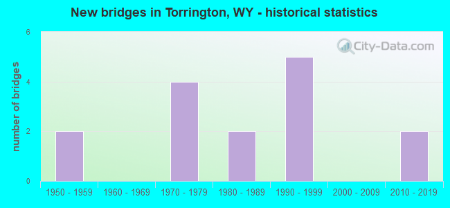
- New bridges - historical statistics
- 21950-1959
- 41970-1979
- 21980-1989
- 51990-1999
- 22010-2019
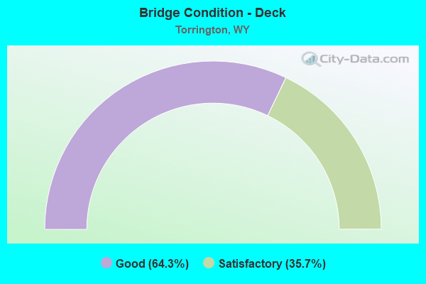
- Bridge Condition - Deck
- 64.3%Good
- 35.7%Satisfactory
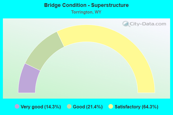
- Bridge Condition - Superstructure
- 14.3%Very good
- 21.4%Good
- 64.3%Satisfactory
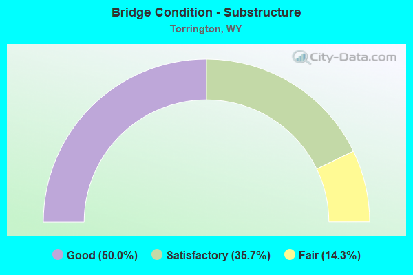
- Bridge Condition - Substructure
- 50.0%Good
- 35.7%Satisfactory
- 14.3%Fair
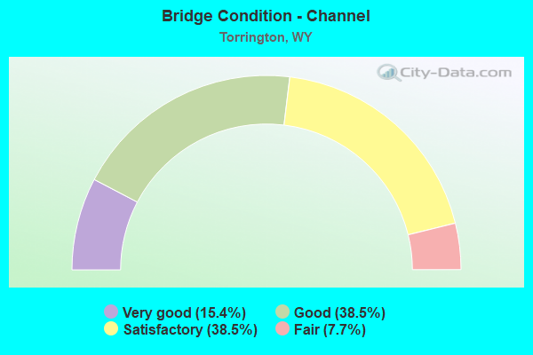
- Bridge Condition - Channel
- 15.4%Very good
- 38.5%Good
- 38.5%Satisfactory
- 7.7%Fair
Find on map >> Show street view
Structure Number: BWK, Location: Cheyenne - Torrington (Lat: 42.035025, Lng: -104.183850), Route carried "on" structure: US 85, Year Built: 1953, Status: Open, Structure Length: 2.04m (6.69ft), Average Daily Traffic: 6,897 (year 2021), Truck Traffic: 6%, Average Future Daily Traffic: 9,656 (year 2041), Design Load: H 20, Features Intersected: Cherry Creek
Minimum Vertical Clearance: 30+ m (98+ ft), Kilometerpoint: 146.898, Lanes on structure: 2, Base Highway Network: Yes (Inventory Route: ML8, Subroute: 2), Owner: State Highway Agency, Approaching Roadway Width: 11.0m (36.1ft), Material/Design: Concrete continuous, Design/Construction: Slab, Number Of Spans In Main Unit: 3, Length of Maximum Span: 7.6m (24.9ft), Curb-To-Curb Width: 12.2m (40.0ft), Out-to-Out Width: 13.1m (43.0ft)
Condition: Deck: Good, Superstructure: Good, Substructure: Good, Channel: Satisfactory, Operating Rating: 37.2 metric tons, Method Used To Determine Operating Rating: Load Factor (LF), Inventory Rating: 22.2 metric tons, Method Used To Determine Inventory Rating: Load Factor (LF), Structural Evaluation: Somewhat better than minimum adequacy, Deck Geometry: Somewhat better than minimum adequacy, Waterway Adequacy: Equal to present desirable criteria, Approach Roadway Alignment: Equal to present desirable criteria, Designated Inspection Frequency: Every 24 months, Inspection Date: April 2021, Deck Structure Type: Concrete Cast-file-Place, Wearing Surface/Protective System: Wearing Surface: Latex Concrete
Find on map >> Show street view
Structure Number: CPM, Location: Torrington - North (Lat: 42.113083, Lng: -104.206247), Route carried "on" structure: State highway 159, Year Built: 1953, Status: Posted for load, Structure Length: 2.64m (8.66ft), Average Daily Traffic: 380 (year 2021), Truck Traffic: 4%, Average Future Daily Traffic: 532 (year 2041), Design Load: H 20, Features Intersected: Interstate Canal
Minimum Vertical Clearance: 30+ m (98+ ft), Kilometerpoint: 6.968, Lanes on structure: 2, Owner: State Highway Agency, Approaching Roadway Width: 6.7m (22.0ft), Material/Design: Concrete continuous, Design/Construction: Slab, Number Of Spans In Main Unit: 3, Length of Maximum Span: 9.9m (32.5ft), Curb-To-Curb Width: 7.3m (24.0ft), Out-to-Out Width: 8.8m (28.9ft)
Condition: Deck: Satisfactory, Superstructure: Satisfactory, Substructure: Satisfactory, Channel: Very good, Operating Rating: 36.6 metric tons, Method Used To Determine Operating Rating: Load Factor (LF), Inventory Rating: 21.9 metric tons, Method Used To Determine Inventory Rating: Load Factor (LF), Structural Evaluation: Equal to present minimum criteria, Deck Geometry: Somewhat better than minimum adequacy, Waterway Adequacy: Equal to present desirable criteria, Approach Roadway Alignment: Equal to present desirable criteria, Bridge Posting: Required (Relationship of Operating Rating to Maximum Legal Load: 0.1 - 9.9% below), Designated Inspection Frequency: Every 12 months, Inspection Date: April 2021, Deck Structure Type: Concrete Cast-file-Place
Find on map >> Show street view
Structure Number: EZF, Location: T24N R061W S30 (Lat: 42.031214, Lng: -104.236342), Route carried "on" structure: County highway 66B, Year Built: 1975, Status: Open, Structure Length: 3.60m (11.81ft), Average Daily Traffic: 181 (year 2021), Truck Traffic: 8%, Average Future Daily Traffic: 253 (year 2041), Design Load: HS 20, Features Intersected: Cherry Creek Drainage
Minimum Vertical Clearance: 30+ m (98+ ft), Kilometerpoint: 2.552, Lanes on structure: 2, Owner: County Highway Agency, Approaching Roadway Width: 6.7m (22.0ft), Skew: 4 degrees, Material/Design: Concrete, Design/Construction: Tee Beam, Number Of Spans In Main Unit: 3, Length of Maximum Span: 11.6m (38.1ft), Curb-To-Curb Width: 7.3m (24.0ft), Out-to-Out Width: 8.2m (26.9ft)
Condition: Deck: Good, Superstructure: Satisfactory, Substructure: Satisfactory, Channel: Good, Operating Rating: 32.7 metric tons, Method Used To Determine Operating Rating: Field evaluation and documented engineering judgment, Inventory Rating: 32.7 metric tons, Method Used To Determine Inventory Rating: Field evaluation and documented engineering judgment, Structural Evaluation: Equal to present minimum criteria, Deck Geometry: Somewhat better than minimum adequacy, Waterway Adequacy: Equal to present desirable criteria, Approach Roadway Alignment: Equal to present desirable criteria, Length Of Structure Improvement: 5.49m (18.01ft), Designated Inspection Frequency: Every 24 months, Inspection Date: January 2022, Bridge Improvement Cost: $2,000, Roadway Improvement Cost: $30,000, Total Project Cost: $33,000 ( Estimate for 2014), Deck Structure Type: Concrete Precast Panels
Find on map >> Show street view
Structure Number: EZG, Location: 3.5 Mi. Sw Of Torrington (Lat: 42.031197, Lng: -104.224394), Route carried "on" structure: County highway 66B, Year Built: 1975, Status: Open, Structure Length: 3.11m (10.20ft), Average Daily Traffic: 181 (year 2021), Truck Traffic: 8%, Average Future Daily Traffic: 253 (year 2041), Design Load: HS 20, Features Intersected: Cherry Creek Drainage
Minimum Vertical Clearance: 30+ m (98+ ft), Kilometerpoint: 1.563, Lanes on structure: 2, Owner: County Highway Agency, Approaching Roadway Width: 6.1m (20.0ft), Skew: 3 degrees, Material/Design: Prestressed concrete, Design/Construction: Stringer/Multi-beam, Number Of Spans In Main Unit: 3, Length of Maximum Span: 11.9m (39.0ft), Curb-To-Curb Width: 7.3m (24.0ft), Out-to-Out Width: 8.2m (26.9ft)
Condition: Deck: Satisfactory, Superstructure: Satisfactory, Substructure: Good, Channel: Good, Operating Rating: 32.7 metric tons, Method Used To Determine Operating Rating: Field evaluation and documented engineering judgment, Inventory Rating: 32.7 metric tons, Method Used To Determine Inventory Rating: Field evaluation and documented engineering judgment, Structural Evaluation: Equal to present minimum criteria, Deck Geometry: Somewhat better than minimum adequacy, Waterway Adequacy: Equal to present desirable criteria, Approach Roadway Alignment: Equal to present desirable criteria, Length Of Structure Improvement: 5.79m (19.00ft), Designated Inspection Frequency: Every 24 months, Inspection Date: January 2021, Bridge Improvement Cost: $8,000, Roadway Improvement Cost: $30,000, Total Project Cost: $41,000, Deck Structure Type: Concrete Precast Panels
Find on map >> Show street view
Structure Number: EZH, Location: 3 Mi. Sw Of Torrington (Lat: 42.031181, Lng: -104.210503), Route carried "on" structure: County highway 66B, Year Built: 1975, Status: Open, Structure Length: 2.99m (9.81ft), Average Daily Traffic: 181 (year 2021), Truck Traffic: 8%, Average Future Daily Traffic: 253 (year 2041), Design Load: HS 20, Features Intersected: Cherry Creek Drainage
Minimum Vertical Clearance: 30+ m (98+ ft), Kilometerpoint: 0.412, Lanes on structure: 2, Owner: County Highway Agency, Approaching Roadway Width: 6.1m (20.0ft), Skew: 3 degrees, Material/Design: Prestressed concrete, Design/Construction: Stringer/Multi-beam, Number Of Spans In Main Unit: 3, Length of Maximum Span: 11.6m (38.1ft), Curb-To-Curb Width: 7.3m (24.0ft), Out-to-Out Width: 8.2m (26.9ft)
Condition: Deck: Good, Superstructure: Satisfactory, Substructure: Satisfactory, Channel: Satisfactory, Operating Rating: 32.7 metric tons, Method Used To Determine Operating Rating: Field evaluation and documented engineering judgment, Inventory Rating: 32.7 metric tons, Method Used To Determine Inventory Rating: Field evaluation and documented engineering judgment, Structural Evaluation: Equal to present minimum criteria, Deck Geometry: Somewhat better than minimum adequacy, Waterway Adequacy: Equal to present desirable criteria, Approach Roadway Alignment: Equal to present desirable criteria, Length Of Structure Improvement: 4.57m (14.99ft), Designated Inspection Frequency: Every 24 months, Inspection Date: January 2021, Bridge Improvement Cost: $10,000, Roadway Improvement Cost: $30,000, Total Project Cost: $45,000, Deck Structure Type: Concrete Precast Panels
Find on map >> Show street view
Structure Number: FAI, Location: 3 Miles N. Of Torrington (Lat: 42.103128, Lng: -104.167306), Route carried "on" structure: County highway 51E, Year Built: 1973, Status: Open, Structure Length: 2.13m (6.99ft), Average Daily Traffic: 41 (year 2021), Truck Traffic: 6%, Average Future Daily Traffic: 57 (year 2041), Design Load: HS 20, Features Intersected: Interstate Canal
Minimum Vertical Clearance: 30+ m (98+ ft), Kilometerpoint: 0.042, Lanes on structure: 2, Owner: County Highway Agency, Approaching Roadway Width: 5.5m (18.0ft), Material/Design: Prestressed concrete, Design/Construction: Tee Beam, Number Of Spans In Main Unit: 2, Length of Maximum Span: 10.7m (35.1ft), Curb or Sidewalk Widths: Left: 0.2m (0.7ft), Right: 0.2m (0.7ft), Curb-To-Curb Width: 5.1m (16.7ft), Out-to-Out Width: 5.5m (18.0ft)
Condition: Deck: Satisfactory, Superstructure: Satisfactory, Substructure: Good, Channel: Very good, Operating Rating: 54.5 metric tons, Method Used To Determine Operating Rating: Field evaluation and documented engineering judgment, Inventory Rating: 32.7 metric tons, Method Used To Determine Inventory Rating: Field evaluation and documented engineering judgment, Structural Evaluation: Equal to present minimum criteria, Deck Geometry: High priority of corrective action, Waterway Adequacy: Equal to present desirable criteria, Approach Roadway Alignment: Somewhat better than minimum adequacy, Length Of Structure Improvement: 6.71m (22.01ft), Designated Inspection Frequency: Every 24 months, Inspection Date: January 2022, Bridge Improvement Cost: $22,000, Roadway Improvement Cost: $30,000, Total Project Cost: $55,000, Deck Structure Type: Concrete Precast Panels
Find on map >> Show street view
Structure Number: FBX, Location: Yoder-Torrington (Lat: 42.016814, Lng: -104.261475), Route carried "on" structure: State highway 154, Year Built: 1986, Status: Open, Structure Length: 5.24m (17.19ft), Average Daily Traffic: 538 (year 2021), Truck Traffic: 4%, Average Future Daily Traffic: 753 (year 2041), Design Load: HS 20, Features Intersected: Cherry Creek
Minimum Vertical Clearance: 30+ m (98+ ft), Kilometerpoint: 6.983, Lanes on structure: 2, Owner: State Highway Agency, Approaching Roadway Width: 11.0m (36.1ft), Skew: 5 degrees, Material/Design: Steel continuous, Design/Construction: Stringer/Multi-beam, Number Of Spans In Main Unit: 3, Length of Maximum Span: 20.1m (65.9ft), Curb-To-Curb Width: 11.0m (36.1ft), Out-to-Out Width: 11.6m (38.1ft)
Condition: Deck: Satisfactory, Superstructure: Good, Substructure: Good, Channel: Good, Operating Rating: 58.1 metric tons, Method Used To Determine Operating Rating: Load Factor (LF), Inventory Rating: 34.5 metric tons, Method Used To Determine Inventory Rating: Load Factor (LF), Structural Evaluation: Better than present minimum criteria, Deck Geometry: Better than present minimum criteria, Waterway Adequacy: Equal to present desirable criteria, Approach Roadway Alignment: Equal to present desirable criteria, Designated Inspection Frequency: Every 24 months, Inspection Date: March 2020, Deck Structure Type: Concrete Cast-file-Place, Wearing Surface/Protective System: Wearing Surface: Latex Concrete
Find on map >> Show street view
Structure Number: FJY, Location: 4.5 Mi Nw Of Torrington (Lat: 42.080967, Lng: -104.266211), Route carried "on" structure: County highway 41B, Year Built: 1987, Status: Open, Structure Length: 10.33m (33.89ft), Average Daily Traffic: 597 (year 2021), Truck Traffic: 8%, Average Future Daily Traffic: 836 (year 2041), Design Load: HS 20, Features Intersected: North Platte River
Minimum Vertical Clearance: 30+ m (98+ ft), Kilometerpoint: 1.817, Lanes on structure: 2, Owner: County Highway Agency, Approaching Roadway Width: 6.7m (22.0ft), Material/Design: Steel continuous, Design/Construction: Stringer/Multi-beam, Number Of Spans In Main Unit: 7, Length of Maximum Span: 14.6m (47.9ft), Curb-To-Curb Width: 9.8m (32.2ft), Out-to-Out Width: 10.6m (34.8ft)
Condition: Deck: Satisfactory, Superstructure: Satisfactory, Substructure: Satisfactory, Channel: Satisfactory, Operating Rating: 65.3 metric tons, Method Used To Determine Operating Rating: Load Factor (LF), Inventory Rating: 39.2 metric tons, Method Used To Determine Inventory Rating: Load Factor (LF), Structural Evaluation: Equal to present minimum criteria, Deck Geometry: Equal to present minimum criteria, Waterway Adequacy: Equal to present desirable criteria, Approach Roadway Alignment: Equal to present desirable criteria, Length Of Structure Improvement: 0.03m (0.10ft), Designated Inspection Frequency: Every 24 months, Inspection Date: January 2021, Bridge Improvement Cost: $2,000, Roadway Improvement Cost: $2,000, Total Project Cost: $5,000, Deck Structure Type: Concrete Cast-file-Place, Wearing Surface/Protective System: Wearing Surface: Bituminous, Deck Protection: Epoxy Coated Reinforcing
Find on map >> Show street view
Structure Number: IXS, Location: West Of Torrington (Lat: 42.015689, Lng: -104.266422), Route carried "on" structure: County highway 41A, Year Built: 1993, Status: Open, Structure Length: 2.59m (8.50ft), Average Daily Traffic: 31 (year 2021), Truck Traffic: 8%, Average Future Daily Traffic: 43 (year 2041), Design Load: HS 20, Features Intersected: Cherry Creek Drainage
Minimum Vertical Clearance: 30+ m (98+ ft), Kilometerpoint: 4.725, Lanes on structure: 2, Owner: County Highway Agency, Approaching Roadway Width: 6.1m (20.0ft), Material/Design: Concrete, Design/Construction: Tee Beam, Number Of Spans In Main Unit: 3, Length of Maximum Span: 8.5m (27.9ft), Curb-To-Curb Width: 7.6m (24.9ft), Out-to-Out Width: 8.3m (27.2ft)
Condition: Deck: Good, Superstructure: Satisfactory, Substructure: Satisfactory, Channel: Satisfactory, Operating Rating: 77.1 metric tons, Method Used To Determine Operating Rating: Load Factor (LF), Inventory Rating: 46.3 metric tons, Method Used To Determine Inventory Rating: Load Factor (LF), Structural Evaluation: Equal to present minimum criteria, Deck Geometry: Equal to present minimum criteria, Waterway Adequacy: Equal to present desirable criteria, Approach Roadway Alignment: Equal to present desirable criteria, Length Of Structure Improvement: 2.59m (8.50ft), Designated Inspection Frequency: Every 24 months, Inspection Date: January 2022, Bridge Improvement Cost: $17,000, Roadway Improvement Cost: $1,000, Total Project Cost: $20,000 ( Estimate for 2014), Deck Structure Type: Concrete Precast Panels
Find on map >> Show street view
Structure Number: IXT, Location: 2.5 Mi S.W Of Torrington (Lat: 42.033061, Lng: -104.208303), Route carried "on" structure: County highway 47B, Year Built: 1993, Status: Open, Structure Length: 2.04m (6.69ft), Average Daily Traffic: 116 (year 2021), Truck Traffic: 8%, Average Future Daily Traffic: 162 (year 2041), Design Load: HS 20, Features Intersected: Cherry Creek Drainage
Minimum Vertical Clearance: 30+ m (98+ ft), Kilometerpoint: 1.407, Lanes on structure: 2, Owner: County Highway Agency, Approaching Roadway Width: 6.1m (20.0ft), Material/Design: Concrete, Design/Construction: Tee Beam, Number Of Spans In Main Unit: 2, Length of Maximum Span: 10.1m (33.1ft), Curb-To-Curb Width: 7.6m (24.9ft), Out-to-Out Width: 8.3m (27.2ft)
Condition: Deck: Good, Superstructure: Satisfactory, Substructure: Good, Channel: Good, Operating Rating: 72.6 metric tons, Method Used To Determine Operating Rating: Load Factor (LF), Inventory Rating: 42.6 metric tons, Method Used To Determine Inventory Rating: Load Factor (LF), Structural Evaluation: Equal to present minimum criteria, Deck Geometry: Somewhat better than minimum adequacy, Waterway Adequacy: Equal to present desirable criteria, Approach Roadway Alignment: Equal to present desirable criteria, Length Of Structure Improvement: 6.61m (21.69ft), Designated Inspection Frequency: Every 24 months, Inspection Date: January 2022, Bridge Improvement Cost: $17,000, Roadway Improvement Cost: $30,000, Total Project Cost: $49,000, Deck Structure Type: Concrete Precast Panels
Find on map >> Show street view
Structure Number: IXU, Location: Apx 1 Mi E Of Torrington (Lat: 42.039386, Lng: -104.169206), Route carried "on" structure: County highway 51C, Year Built: 1993, Status: Open, Structure Length: 1.98m (6.50ft), Average Daily Traffic: 41 (year 2021), Truck Traffic: 6%, Average Future Daily Traffic: 57 (year 2041), Design Load: HS 20, Features Intersected: Cherry Creek Drainage
Minimum Vertical Clearance: 30+ m (98+ ft), Kilometerpoint: 1.942, Lanes on structure: 2, Owner: County Highway Agency, Approaching Roadway Width: 6.1m (20.0ft), Skew: 2 degrees, Material/Design: Concrete, Design/Construction: Tee Beam, Number Of Spans In Main Unit: 2, Length of Maximum Span: 9.8m (32.2ft), Curb-To-Curb Width: 7.6m (24.9ft), Out-to-Out Width: 8.3m (27.2ft)
Condition: Deck: Good, Superstructure: Good, Substructure: Fair, Channel: Fair, Operating Rating: 78.0 metric tons, Method Used To Determine Operating Rating: Load Factor (LF), Inventory Rating: 46.3 metric tons, Method Used To Determine Inventory Rating: Load Factor (LF), Structural Evaluation: Somewhat better than minimum adequacy, Deck Geometry: Equal to present minimum criteria, Waterway Adequacy: Equal to present desirable criteria, Approach Roadway Alignment: Equal to present desirable criteria, Length Of Structure Improvement: 1.98m (6.50ft), Designated Inspection Frequency: Every 24 months, Inspection Date: January 2022, Bridge Improvement Cost: $15,000, Roadway Improvement Cost: $1,000, Total Project Cost: $18,000 ( Estimate for 2014), Deck Structure Type: Concrete Precast Panels
Find on map >> Show street view
Structure Number: IXV, Location: 4 Miles W. Of Torrington (Lat: 42.045875, Lng: -104.264717), Route carried "on" structure: County highway 68C, Year Built: 1993, Status: Open, Structure Length: 2.96m (9.71ft), Average Daily Traffic: 41 (year 2021), Truck Traffic: 6%, Average Future Daily Traffic: 57 (year 2041), Design Load: HS 20, Features Intersected: Fort Laramie Canal
Minimum Vertical Clearance: 30+ m (98+ ft), Kilometerpoint: 0.183, Lanes on structure: 2, Owner: County Highway Agency, Approaching Roadway Width: 5.2m (17.1ft), Skew: 2 degrees, Material/Design: Concrete, Design/Construction: Tee Beam, Number Of Spans In Main Unit: 3, Length of Maximum Span: 9.8m (32.2ft), Curb-To-Curb Width: 7.5m (24.6ft), Out-to-Out Width: 8.2m (26.9ft)
Condition: Deck: Good, Superstructure: Satisfactory, Substructure: Fair, Channel: Satisfactory, Operating Rating: 78.0 metric tons, Method Used To Determine Operating Rating: Load Factor (LF), Inventory Rating: 46.3 metric tons, Method Used To Determine Inventory Rating: Load Factor (LF), Structural Evaluation: Somewhat better than minimum adequacy, Deck Geometry: Equal to present minimum criteria, Waterway Adequacy: Equal to present desirable criteria, Approach Roadway Alignment: Equal to present minimum criteria, Length Of Structure Improvement: 7.53m (24.70ft), Designated Inspection Frequency: Every 24 months, Inspection Date: January 2022, Bridge Improvement Cost: $24,000, Roadway Improvement Cost: $30,000, Total Project Cost: $66,000, Deck Structure Type: Concrete Precast Panels
Find on map >> Show street view
Structure Number: JBI, Location: Torrington South Road (Lat: 42.052839, Lng: -104.184319), Route carried "on" structure: US 85, Year Built: 1994, Status: Open, Structure Length: 11.89m (39.01ft), Average Daily Traffic: 6,897 (year 2021), Truck Traffic: 6%, Average Future Daily Traffic: 9,656 (year 2041), Design Load: HS 20, Features Intersected: North Platte River
Minimum Vertical Clearance: 30+ m (98+ ft), Kilometerpoint: 148.879, Lanes on structure: 4, Base Highway Network: Yes (Inventory Route: ML8, Subroute: 2), Owner: State Highway Agency, Approaching Roadway Width: 17.7m (58.1ft), Skew: 1 degrees, Material/Design: Steel continuous, Design/Construction: Stringer/Multi-beam, Number Of Spans In Main Unit: 5, Length of Maximum Span: 30.5m (100.1ft), Curb or Sidewalk Widths: Left: 1.5m (4.9ft), Right: 1.5m (4.9ft), Curb-To-Curb Width: 18.3m (60.0ft), Out-to-Out Width: 22.6m (74.1ft)
Condition: Deck: Good, Superstructure: Very good, Substructure: Good, Channel: Good, Operating Rating: 73.5 metric tons, Method Used To Determine Operating Rating: Load Factor (LF), Inventory Rating: 43.5 metric tons, Method Used To Determine Inventory Rating: Load Factor (LF), Structural Evaluation: Better than present minimum criteria, Deck Geometry: Somewhat better than minimum adequacy, Waterway Adequacy: Equal to present desirable criteria, Approach Roadway Alignment: Equal to present desirable criteria, Designated Inspection Frequency: Every 24 months, Underwater Inspection Frequency: Every 60 months, Inspection Date: April 2021, Underwater Inspection Date: October 2019, Deck Structure Type: Concrete Cast-file-Place
Find on map >> Show street view
Structure Number: MHB, Location: Torrington Streets (Lat: 42.058581, Lng: -104.176933), Route carried "on" structure: US 85, Year Built: 2013, Status: Open, Structure Length: 9.14m (29.99ft), Average Daily Traffic: 1,062 (year 2021), Truck Traffic: 10%, Average Future Daily Traffic: 1,487 (year 2041), Design Load: HL 93, Features Intersected: BNSF Railway / US 26
Minimum Vertical Clearance: 30+ m (98+ ft), Kilometerpoint: 0.835, Lanes on structure: 4, Lanes under structure: 3, Base Highway Network: Yes (Inventory Route: ML2022, Subroute: 2), Owner: State Highway Agency, Approaching Roadway Width: 19.5m (64.0ft), Material/Design: Steel continuous, Design/Construction: Stringer/Multi-beam, Number Of Spans In Main Unit: 4, Length of Maximum Span: 30.5m (100.1ft), Curb or Sidewalk Widths: Left: 1.5m (4.9ft), Right: 1.5m (4.9ft), Curb-To-Curb Width: 19.5m (64.0ft), Out-to-Out Width: 24.1m (79.1ft)
Condition: Deck: Good, Superstructure: Very good, Substructure: Good, Operating Rating: 51.8 metric tons, Method Used To Determine Operating Rating: Load and Resistance Factor Rating (LRFR) rating reported by rating factor(RF) method using HL-93 loadings, Inventory Rating: 39.9 metric tons, Method Used To Determine Inventory Rating: Load and Resistance Factor Rating (LRFR) rating reported by rating factor(RF) method using HL-93 loadings, Structural Evaluation: Better than present minimum criteria, Deck Geometry: Better than present minimum criteria, Underclear: Better than present minimum criteria, Approach Roadway Alignment: Equal to present minimum criteria, Designated Inspection Frequency: Every 24 months, Inspection Date: April 2021, Deck Structure Type: Concrete Cast-file-Place, Wearing Surface/Protective System: Deck Protection: Epoxy Coated Reinforcing
Find on map >> Show street view
Structure Number: MHB, Location: Torrington Streets (Lat: 42.058581, Lng: -104.176933), Route carried "under" structure: US 85, Year Built: 2013, Structure Length: 0. m, Average Daily Traffic: 4,162 (year 2021), Truck Traffic: 15%, Features Intersected: BNSF Railway / US 26
Minimum Vertical Clearance: 7.85m (25.75ft), Kilometerpoint: 78.494, Lanes on structure: 4, Lanes under structure: 3, Material/Design: Steel continuous, Design/Construction: Stringer/Multi-beam, Length of Maximum Span: 30.5m (100.1ft)