Bridge Statistics for Timberlake, Virginia (VA)
Condition, Traffic, Stress, Structural Evaluation, Project Costs
- National Bridge Inventory (NBI) Statistics
- 21Number of bridges
- 161ft / 48.9mTotal length
- $2,199,000Total costs
- 149,898Total average daily traffic
- 10,753Total average daily truck traffic
- National Bridge Inventory (NBI) Registered Bridges for Timberlake
- No street view available for this location
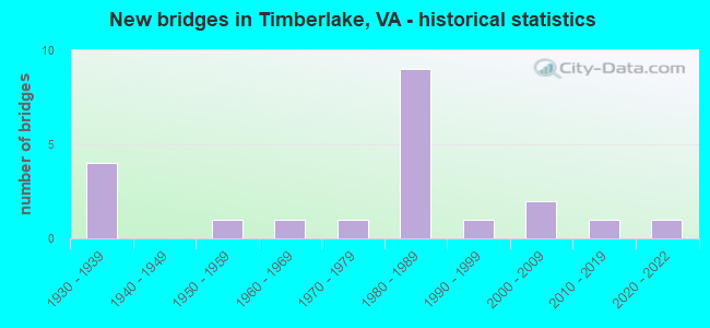
- New bridges - historical statistics
- 41930-1939
- 11950-1959
- 11960-1969
- 11970-1979
- 91980-1989
- 11990-1999
- 22000-2009
- 12010-2019
- 12020-2022


- Bridge Condition - Deck
- 21.4%Very good
- 42.9%Good
- 28.6%Satisfactory
- 7.1%Fair

- Bridge Condition - Superstructure
- 7.1%Excellent
- 14.3%Very good
- 42.9%Good
- 21.4%Satisfactory
- 14.3%Fair

- Bridge Condition - Substructure
- 7.1%Very good
- 64.3%Good
- 21.4%Satisfactory
- 7.1%Fair

- Bridge Condition - Channel
- 16.7%Very good
- 25.0%Good
- 41.7%Satisfactory
- 16.7%Fair

- Bridge Condition - Culverts
- 33.3%Satisfactory
- 33.3%Fair
- 33.3%Poor
Find on map >> Show street view
Structure Number: 2937, Location: 0.02 Rt 649; 0.02 Cpbl Co (Lat: 37.304000, Lng: -79.291194), Route carried "on" structure: County highway 858, Year Built: 1932, Status: Open, Structure Length: 0.77m (2.53ft), Average Daily Traffic: 467 (year 2020), Truck Traffic: 1%, Average Future Daily Traffic: 654 (year 2040), Features Intersected: Buffalo Creek
Minimum Vertical Clearance: 30+ m (98+ ft), Kilometerpoint: 0.032, Lanes on structure: 2, Owner: State Highway Agency, Approaching Roadway Width: 5.2m (17.1ft), Material/Design: Steel, Design/Construction: Stringer/Multi-beam, Number Of Spans In Main Unit: 1, Length of Maximum Span: 7.7m (25.3ft), Curb or Sidewalk Widths: Left: 0.3m (1.0ft), Right: 0.3m (1.0ft), Curb-To-Curb Width: 7.2m (23.6ft), Out-to-Out Width: 7.8m (25.6ft)
Condition: Deck: Very good, Superstructure: Very good, Substructure: Satisfactory, Channel: Very good, Operating Rating: 60.8 metric tons, Method Used To Determine Operating Rating: Load and Resistance Factor (LRFR), Inventory Rating: 46.3 metric tons, Method Used To Determine Inventory Rating: Load and Resistance Factor (LRFR), Structural Evaluation: Equal to present minimum criteria, Deck Geometry: Meets minimum limits, Waterway Adequacy: Better than present minimum criteria, Approach Roadway Alignment: Equal to present desirable criteria, Designated Inspection Frequency: Every 24 months, Inspection Date: August 2021, Deck Structure Type: Wood or Timber, Wearing Surface/Protective System: Wearing Surface: Bituminous
Find on map >> Show street view
Structure Number: 4133, Location: .02-Rt F975 / .10-Rt 460 (Lat: 37.313950, Lng: -79.260967), Route carried "on" structure: ServiceCounty highway F974, Year Built: 1987, Status: Open, Structure Length: 0.71m (2.33ft), Average Daily Traffic: 928 (year 2016), Average Future Daily Traffic: 1,039 (year 2040), Features Intersected: Buffalo Creek, Facility Carried by Structure: Martin Drive
Minimum Vertical Clearance: 30+ m (98+ ft), Kilometerpoint: 0.048, Lanes on structure: 2, Owner: State Highway Agency, Approaching Roadway Width: 6.1m (20.0ft), Skew: 2 degrees, Material/Design: Steel, Design/Construction: Culvert, Number Of Spans In Main Unit: 2, Length of Maximum Span: 2.7m (8.9ft)
Condition: Channel: Satisfactory, Culverts: Fair, Operating Rating: 52.6 metric tons, Method Used To Determine Operating Rating: Field evaluation and documented engineering judgment, Inventory Rating: 31.8 metric tons, Method Used To Determine Inventory Rating: Field evaluation and documented engineering judgment, Structural Evaluation: Somewhat better than minimum adequacy, Waterway Adequacy: Equal to present desirable criteria, Approach Roadway Alignment: Meets minimum limits, Length Of Structure Improvement: 0.64m (2.10ft), Designated Inspection Frequency: Every 24 months, Inspection Date: May 2021, Bridge Improvement Cost: $204,000, Roadway Improvement Cost: $20,000, Total Project Cost: $306,000 ( Estimate for 2015)
Find on map >> Show street view
Structure Number: 4134, Location: 1.45-Rt.692 / 0.95-Rt.696 (Lat: 37.232958, Lng: -79.261906), Route carried "on" structure: State highway 24, Year Built: 1932, Status: Open, Structure Length: 2.99m (9.81ft), Average Daily Traffic: 1,282 (year 2020), Truck Traffic: 2%, Average Future Daily Traffic: 1,410 (year 2040), Features Intersected: Flat Creek, Facility Carried by Structure: Colonial Highway
Minimum Vertical Clearance: 30+ m (98+ ft), Kilometerpoint: 68.756, Lanes on structure: 2, Base Highway Network: Yes, Owner: State Highway Agency, Approaching Roadway Width: 6.4m (21.0ft), Material/Design: Concrete, Design/Construction: Tee Beam, Number Of Spans In Main Unit: 3, Length of Maximum Span: 10.1m (33.1ft), Curb or Sidewalk Widths: Left: 0.4m (1.3ft), Right: 0.4m (1.3ft), Curb-To-Curb Width: 7.0m (23.0ft), Out-to-Out Width: 8.0m (26.2ft)
Condition: Deck: Satisfactory, Superstructure: Satisfactory, Substructure: Satisfactory, Channel: Fair, Operating Rating: 48.1 metric tons, Method Used To Determine Operating Rating: Load Factor (LF), Inventory Rating: 29.0 metric tons, Method Used To Determine Inventory Rating: Load Factor (LF), Structural Evaluation: Equal to present minimum criteria, Deck Geometry: High priority of corrective action, Waterway Adequacy: Somewhat better than minimum adequacy, Approach Roadway Alignment: Better than present minimum criteria, Length Of Structure Improvement: 3.29m (10.79ft), Designated Inspection Frequency: Every 24 months, Inspection Date: August 2021, Bridge Improvement Cost: $545,000, Roadway Improvement Cost: $55,000, Total Project Cost: $818,000 ( Estimate for 2015), Deck Structure Type: Concrete Cast-file-Place, Wearing Surface/Protective System: Wearing Surface: Bituminous
Find on map >> Show street view
Structure Number: 4172, Location: 0.06-Bed Co/1.34-460 Bus (Lat: 37.305069, Lng: -79.289892), Route carried "on" structure: US 460, Year Built: 1955, Status: Open, Structure Length: 2.00m (6.56ft), Average Daily Traffic: 11,313 (year 2020), Truck Traffic: 11%, Average Future Daily Traffic: 15,840 (year 2040), Features Intersected: Buffalo Creek
Minimum Vertical Clearance: 30+ m (98+ ft), Kilometerpoint: 314.801, Lanes on structure: 2, Base Highway Network: Yes, Owner: State Highway Agency, Approaching Roadway Width: 8.5m (27.9ft), Skew: 4 degrees, Material/Design: Steel, Design/Construction: Stringer/Multi-beam, Number Of Spans In Main Unit: 1, Length of Maximum Span: 19.4m (63.6ft), Curb or Sidewalk Widths: Left: 0.5m (1.6ft), Right: 0.5m (1.6ft), Curb-To-Curb Width: 8.5m (27.9ft), Out-to-Out Width: 9.4m (30.8ft)
Condition: Deck: Satisfactory, Superstructure: Satisfactory, Substructure: Satisfactory, Channel: Good, Operating Rating: 45.4 metric tons, Method Used To Determine Operating Rating: Load and Resistance Factor (LRFR), Inventory Rating: 34.5 metric tons, Method Used To Determine Inventory Rating: Load and Resistance Factor (LRFR), Structural Evaluation: Equal to present minimum criteria, Deck Geometry: High priority of corrective action, Waterway Adequacy: Equal to present minimum criteria, Approach Roadway Alignment: Equal to present desirable criteria, Length Of Structure Improvement: 2.77m (9.09ft), Designated Inspection Frequency: Every 24 months, Inspection Date: January 2022, Bridge Improvement Cost: $461,000, Roadway Improvement Cost: $47,000, Total Project Cost: $692,000 ( Estimate for 2016), Deck Structure Type: Concrete Cast-file-Place, Wearing Surface/Protective System: Wearing Surface: Latex Concrete
Find on map >> Show street view
Structure Number: 4186, Location: 0.31-Rt.681/1.18-Rt.682 (Lat: 37.310425, Lng: -79.262769), Route carried "on" structure: Business County highway 460, Year Built: 1987, Status: Open, Structure Length: 4.91m (16.11ft), Average Daily Traffic: 11,756 (year 2020), Truck Traffic: 9%, Average Future Daily Traffic: 16,458 (year 2040), Features Intersected: Rt 460 Business
Minimum Vertical Clearance: 30+ m (98+ ft), Kilometerpoint: 319.306, Lanes on structure: 2, Lanes under structure: 2, Base Highway Network: Yes, Owner: State Highway Agency, Approaching Roadway Width: 11.6m (38.1ft), Material/Design: Prestressed concrete, Design/Construction: Stringer/Multi-beam, Number Of Spans In Main Unit: 3, Length of Maximum Span: 22.6m (74.1ft), Curb-To-Curb Width: 11.7m (38.4ft), Out-to-Out Width: 12.7m (41.7ft)
Condition: Deck: Satisfactory, Superstructure: Satisfactory, Substructure: Good, Operating Rating: 89.8 metric tons, Method Used To Determine Operating Rating: Load and Resistance Factor (LRFR), Inventory Rating: 64.4 metric tons, Method Used To Determine Inventory Rating: Load and Resistance Factor (LRFR), Structural Evaluation: Equal to present minimum criteria, Deck Geometry: Equal to present minimum criteria, Underclear: Equal to present minimum criteria, Approach Roadway Alignment: Equal to present desirable criteria, Designated Inspection Frequency: Every 24 months, Inspection Date: July 2021, Deck Structure Type: Concrete Cast-file-Place, Wearing Surface/Protective System: Deck Protection: Epoxy Coated Reinforcing
Find on map >> Show street view
Structure Number: 4188, Location: 0.31-Rt.681 /1.18-Rt.682 (Lat: 37.310150, Lng: -79.262931), Route carried "on" structure: Business US 460, Year Built: 1987, Status: Open, Structure Length: 4.39m (14.40ft), Average Daily Traffic: 11,756 (year 2020), Truck Traffic: 9%, Average Future Daily Traffic: 16,458 (year 2040), Design Load: HS 20+Mod, Features Intersected: Rt 460 Business
Minimum Vertical Clearance: 30+ m (98+ ft), Kilometerpoint: 319.311, Lanes on structure: 3, Lanes under structure: 2, Base Highway Network: Yes, Owner: State Highway Agency, Approaching Roadway Width: 15.2m (49.9ft), Material/Design: Prestressed concrete, Design/Construction: Stringer/Multi-beam, Number Of Spans In Main Unit: 3, Length of Maximum Span: 22.6m (74.1ft), Curb-To-Curb Width: 15.4m (50.5ft), Out-to-Out Width: 16.4m (53.8ft)
Condition: Deck: Satisfactory, Superstructure: Good, Substructure: Good, Operating Rating: 89.8 metric tons, Method Used To Determine Operating Rating: Load and Resistance Factor (LRFR), Inventory Rating: 61.7 metric tons, Method Used To Determine Inventory Rating: Load and Resistance Factor (LRFR), Structural Evaluation: Better than present minimum criteria, Deck Geometry: Equal to present minimum criteria, Underclear: Equal to present minimum criteria, Approach Roadway Alignment: Equal to present desirable criteria, Designated Inspection Frequency: Every 24 months, Inspection Date: July 2021, Deck Structure Type: Concrete Cast-file-Place, Wearing Surface/Protective System: Deck Protection: Epoxy Coated Reinforcing
Find on map >> Show street view
Structure Number: 419, Location: 0.06-Bed. Cl/1.34-460Bus (Lat: 37.304894, Lng: -79.290089), Route carried "on" structure: US 460, Year Built: 1969, Status: Open, Structure Length: 1.97m (6.46ft), Average Daily Traffic: 11,313 (year 2020), Truck Traffic: 11%, Average Future Daily Traffic: 15,840 (year 2040), Features Intersected: Buffalo Creek, Facility Carried by Structure: E. Lynch Salem Tur
Minimum Vertical Clearance: 30+ m (98+ ft), Kilometerpoint: 314.801, Lanes on structure: 2, Base Highway Network: Yes, Owner: State Highway Agency, Approaching Roadway Width: 7.9m (25.9ft), Skew: 4 degrees, Material/Design: Steel, Design/Construction: Stringer/Multi-beam, Number Of Spans In Main Unit: 1, Length of Maximum Span: 18.3m (60.0ft), Curb or Sidewalk Widths: Left: 0.6m (2.0ft), Right: 0.6m (2.0ft), Curb-To-Curb Width: 12.0m (39.4ft), Out-to-Out Width: 13.2m (43.3ft)
Condition: Deck: Good, Superstructure: Fair, Substructure: Fair, Channel: Fair, Operating Rating: 63.5 metric tons, Method Used To Determine Operating Rating: Load and Resistance Factor (LRFR), Inventory Rating: 49.0 metric tons, Method Used To Determine Inventory Rating: Load and Resistance Factor (LRFR), Structural Evaluation: Somewhat better than minimum adequacy, Deck Geometry: Better than present minimum criteria, Waterway Adequacy: Better than present minimum criteria, Approach Roadway Alignment: Equal to present desirable criteria, Designated Inspection Frequency: Every 24 months, Inspection Date: September 2020, Deck Structure Type: Concrete Cast-file-Place, Wearing Surface/Protective System: Wearing Surface: Bituminous
Find on map >> Show street view
Structure Number: 4224, Location: 0.12-Rt 1577/0.10-Rt 681 (Lat: 37.314983, Lng: -79.226286), Route carried "on" structure: County highway 622, Year Built: 1986, Status: Open, Structure Length: 6.55m (21.49ft), Average Daily Traffic: 5,676 (year 2020), Truck Traffic: 2%, Average Future Daily Traffic: 7,946 (year 2040), Design Load: HS 20+Mod, Features Intersected: Rt. 460 Bypass, Facility Carried by Structure: Waterlick Road
Minimum Vertical Clearance: 30+ m (98+ ft), Kilometerpoint: 4.650, Lanes on structure: 2, Lanes under structure: 4, Owner: State Highway Agency, Approaching Roadway Width: 8.5m (27.9ft), Skew: 1 degrees, Material/Design: Steel continuous, Design/Construction: Stringer/Multi-beam, Number Of Spans In Main Unit: 2, Length of Maximum Span: 32.5m (106.6ft), Curb-To-Curb Width: 8.7m (28.5ft), Out-to-Out Width: 9.7m (31.8ft)
Condition: Deck: Good, Superstructure: Good, Substructure: Good, Operating Rating: 74.4 metric tons, Method Used To Determine Operating Rating: Load and Resistance Factor (LRFR), Inventory Rating: 57.2 metric tons, Method Used To Determine Inventory Rating: Load and Resistance Factor (LRFR), Structural Evaluation: Better than present minimum criteria, Deck Geometry: Meets minimum limits, Underclear: Equal to present minimum criteria, Approach Roadway Alignment: Equal to present desirable criteria, Designated Inspection Frequency: Every 24 months, Inspection Date: July 2021, Deck Structure Type: Concrete Cast-file-Place, Wearing Surface/Protective System: Wearing Surface: Epoxy Overlay, Deck Protection: Epoxy Coated Reinforcing
Find on map >> Show street view
Structure Number: 4228, Location: .19-Rt 460 / .18-Rt 1400 (Lat: 37.307758, Lng: -79.281175), Route carried "on" structure: County highway 623, Year Built: 1974, Status: Open, Structure Length: 0.82m (2.69ft), Average Daily Traffic: 354 (year 2020), Average Future Daily Traffic: 375 (year 2040), Design Load: HS 20, Features Intersected: Buffalo Creek, Facility Carried by Structure: Turkeyfoot Road
Minimum Vertical Clearance: 30+ m (98+ ft), Kilometerpoint: 5.406, Lanes on structure: 1, Owner: State Highway Agency, Approaching Roadway Width: 6.7m (22.0ft), Material/Design: Steel, Design/Construction: Culvert, Number Of Spans In Main Unit: 2, Length of Maximum Span: 4.0m (13.1ft)
Condition: Channel: Satisfactory, Culverts: Poor, Operating Rating: 44.5 metric tons, Method Used To Determine Operating Rating: Field evaluation and documented engineering judgment, Inventory Rating: 32.7 metric tons, Method Used To Determine Inventory Rating: Field evaluation and documented engineering judgment, Structural Evaluation: Meets minimum limits, Waterway Adequacy: Equal to present minimum criteria, Approach Roadway Alignment: Equal to present desirable criteria, Designated Inspection Frequency: Every 24 months, Inspection Date: Febuary 2021
Find on map >> Show street view
Structure Number: 4229, Location: .70-Rt 460/.02-End St Mnt (Lat: 37.312697, Lng: -79.272814), Route carried "on" structure: County highway 624, Year Built: 1932, Status: Posted for load, Structure Length: 0.85m (2.79ft), Average Daily Traffic: 269 (year 2016), Average Future Daily Traffic: 320 (year 2040), Features Intersected: Timberlake Spillway, Facility Carried by Structure: SouthTimberlake Rd
Minimum Vertical Clearance: 30+ m (98+ ft), Kilometerpoint: 1.126, Lanes on structure: 2, Owner: State Highway Agency, Approaching Roadway Width: 3.8m (12.5ft), Material/Design: Concrete, Design/Construction: Arch - Deck, Number Of Spans In Main Unit: 1, Length of Maximum Span: 7.9m (25.9ft), Curb-To-Curb Width: 5.7m (18.7ft), Out-to-Out Width: 5.9m (19.4ft)
Condition: Deck: Fair, Superstructure: Fair, Substructure: Good, Channel: Good, Operating Rating: 18.1 metric tons, Method Used To Determine Operating Rating: Field evaluation and documented engineering judgment, Inventory Rating: 10.9 metric tons, Method Used To Determine Inventory Rating: Field evaluation and documented engineering judgment, Structural Evaluation: Meets minimum limits, Deck Geometry: High priority of corrective action, Waterway Adequacy: Equal to present minimum criteria, Approach Roadway Alignment: Equal to present desirable criteria, Bridge Posting: Required (Relationship of Operating Rating to Maximum Legal Load: > 39.9% below), Length Of Structure Improvement: 1.46m (4.79ft), Designated Inspection Frequency: Every 12 months, Inspection Date: August 2021, Bridge Improvement Cost: $255,000, Roadway Improvement Cost: $26,000, Total Project Cost: $383,000 ( Estimate for 2015)
Find on map >> Show street view
Structure Number: 4295, Location: 0.03-Rt 683 /0.51-Rt 725 (Lat: 37.241664, Lng: -79.280375), Route carried "on" structure: County highway 682, Year Built: 1988, Status: Open, Structure Length: 4.63m (15.19ft), Average Daily Traffic: 2,930 (year 2020), Truck Traffic: 2%, Average Future Daily Traffic: 3,532 (year 2040), Features Intersected: NS Railway, Facility Carried by Structure: Leesville Road
Minimum Vertical Clearance: 30+ m (98+ ft), Kilometerpoint: 19.565, Lanes on structure: 2, Owner: State Highway Agency, Approaching Roadway Width: 7.7m (25.3ft), Skew: 1 degrees, Material/Design: Steel, Design/Construction: Stringer/Multi-beam, Number Of Spans In Main Unit: 3, Length of Maximum Span: 21.3m (69.9ft), Curb-To-Curb Width: 8.7m (28.5ft), Out-to-Out Width: 9.7m (31.8ft)
Condition: Deck: Good, Superstructure: Good, Substructure: Good, Operating Rating: 68.0 metric tons, Method Used To Determine Operating Rating: Load and Resistance Factor (LRFR), Inventory Rating: 52.6 metric tons, Method Used To Determine Inventory Rating: Load and Resistance Factor (LRFR), Structural Evaluation: Better than present minimum criteria, Deck Geometry: Meets minimum limits, Underclear: Better than present minimum criteria, Approach Roadway Alignment: Equal to present minimum criteria, Designated Inspection Frequency: Every 24 months, Inspection Date: March 2020, Deck Structure Type: Concrete Cast-file-Place, Wearing Surface/Protective System: Wearing Surface: Epoxy Overlay, Deck Protection: Epoxy Coated Reinforcing
Find on map >> Show street view
Structure Number: 4307, Location: 0.70-Rt.617/1.04-Rt.950 (Lat: 37.271619, Lng: -79.205333), Route carried "on" structure: County highway 690, Year Built: 1932, Year Reconstructed: 2009, Status: Open, Structure Length: 1.04m (3.41ft), Average Daily Traffic: 483 (year 2019), Average Future Daily Traffic: 516 (year 2040), Design Load: HS 20+Mod, Features Intersected: Tributary Flat Creek, Facility Carried by Structure: Clarks Road
Minimum Vertical Clearance: 30+ m (98+ ft), Kilometerpoint: 2.424, Lanes on structure: 2, Base Highway Network: Yes, Owner: State Highway Agency, Approaching Roadway Width: 5.5m (18.0ft), Material/Design: Steel, Design/Construction: Stringer/Multi-beam, Number Of Spans In Main Unit: 1, Length of Maximum Span: 9.3m (30.5ft), Curb-To-Curb Width: 7.3m (24.0ft), Out-to-Out Width: 7.3m (24.0ft)
Condition: Deck: Very good, Superstructure: Good, Substructure: Good, Channel: Satisfactory, Operating Rating: 51.7 metric tons, Method Used To Determine Operating Rating: Load and Resistance Factor (LRFR), Inventory Rating: 39.0 metric tons, Method Used To Determine Inventory Rating: Load and Resistance Factor (LRFR), Structural Evaluation: Better than present minimum criteria, Deck Geometry: Meets minimum limits, Waterway Adequacy: Somewhat better than minimum adequacy, Approach Roadway Alignment: Equal to present minimum criteria, Designated Inspection Frequency: Every 24 months, Inspection Date: December 2021, Deck Structure Type: Wood or Timber, Wearing Surface/Protective System: Wearing Surface: Bituminous, Membrane: Preformed Fabric
Find on map >> Show street view
Structure Number: 25312, Location: 0.99-Rt.681 / 0.26-Rt.683 (Lat: 37.300844, Lng: -79.212036), Route carried "on" structure: County highway 622, Year Built: 2001, Status: Open, Structure Length: 3.97m (13.02ft), Average Daily Traffic: 5,676 (year 2020), Truck Traffic: 1%, Average Future Daily Traffic: 7,946 (year 2040), Features Intersected: NS Railway, Facility Carried by Structure: Waterlick Rd.
Minimum Vertical Clearance: 30+ m (98+ ft), Kilometerpoint: 0.000, Lanes on structure: 2, Owner: State Highway Agency, Approaching Roadway Width: 7.9m (25.9ft), Skew: 2 degrees, Material/Design: Steel, Design/Construction: Stringer/Multi-beam, Number Of Spans In Main Unit: 1, Length of Maximum Span: 39.7m (130.2ft), Curb-To-Curb Width: 9.8m (32.2ft), Out-to-Out Width: 10.8m (35.4ft)
Condition: Deck: Good, Superstructure: Good, Substructure: Good, Operating Rating: 49.9 metric tons, Method Used To Determine Operating Rating: Load and Resistance Factor (LRFR), Inventory Rating: 38.1 metric tons, Method Used To Determine Inventory Rating: Load and Resistance Factor (LRFR), Structural Evaluation: Better than present minimum criteria, Deck Geometry: Meets minimum limits, Underclear: Superior to present desirable criteria, Approach Roadway Alignment: Equal to present desirable criteria, Designated Inspection Frequency: Every 24 months, Inspection Date: July 2021, Deck Structure Type: Concrete Cast-file-Place
Find on map >> Show street view
Structure Number: 26274, Location: 0.65-Rt.871 / 0.15-Rt.625 (Lat: 37.290003, Lng: -79.274714), Route carried "on" structure: County highway 623, Year Built: 1999, Status: Open, Structure Length: 3.69m (12.11ft), Average Daily Traffic: 1,128 (year 2020), Truck Traffic: 1%, Average Future Daily Traffic: 1,241 (year 2040), Design Load: HS 20+Mod, Features Intersected: Buffalo Creek, Facility Carried by Structure: Town Fork Road
Minimum Vertical Clearance: 30+ m (98+ ft), Kilometerpoint: 2.977, Lanes on structure: 2, Owner: State Highway Agency, Approaching Roadway Width: 7.9m (25.9ft), Skew: 2 degrees, Material/Design: Prestressed concrete, Design/Construction: Box Beam or Girders - Multiple, Number Of Spans In Main Unit: 2, Length of Maximum Span: 18.3m (60.0ft), Curb-To-Curb Width: 11.6m (38.1ft), Out-to-Out Width: 12.2m (40.0ft)
Condition: Deck: Good, Superstructure: Good, Substructure: Good, Channel: Satisfactory, Inventory Rating: 44.5 metric tons, Method Used To Determine Inventory Rating: Load and Resistance Factor (LRFR), Structural Evaluation: Better than present minimum criteria, Deck Geometry: Equal to present minimum criteria, Waterway Adequacy: Meets minimum limits, Approach Roadway Alignment: Equal to present minimum criteria, Designated Inspection Frequency: Every 24 months, Inspection Date: December 2021, Deck Structure Type: Other, Wearing Surface/Protective System: Wearing Surface: Bituminous
Find on map >> Show street view
Structure Number: 28033, Location: 2.93 Rt 625/1.37 Rt 682 (Lat: 37.261944, Lng: -79.294717), Route carried "on" structure: County highway 684, Year Built: 2004, Status: Open, Structure Length: 3.72m (12.20ft), Average Daily Traffic: 342 (year 2016), Average Future Daily Traffic: 506 (year 2040), Design Load: HS 20+Mod, Features Intersected: Buffalo Creek, Facility Carried by Structure: Buffalo Mill Road
Minimum Vertical Clearance: 30+ m (98+ ft), Kilometerpoint: 3.105, Lanes on structure: 2, Owner: State Highway Agency, Approaching Roadway Width: 7.3m (24.0ft), Material/Design: Steel, Design/Construction: Stringer/Multi-beam, Number Of Spans In Main Unit: 1, Length of Maximum Span: 34.7m (113.8ft), Curb-To-Curb Width: 7.8m (25.6ft), Out-to-Out Width: 8.8m (28.9ft)
Condition: Deck: Good, Superstructure: Very good, Substructure: Good, Channel: Good, Operating Rating: 64.4 metric tons, Method Used To Determine Operating Rating: Load and Resistance Factor (LRFR), Inventory Rating: 49.9 metric tons, Method Used To Determine Inventory Rating: Load and Resistance Factor (LRFR), Structural Evaluation: Better than present minimum criteria, Deck Geometry: Somewhat better than minimum adequacy, Waterway Adequacy: Equal to present desirable criteria, Approach Roadway Alignment: Equal to present desirable criteria, Designated Inspection Frequency: Every 24 months, Inspection Date: July 2021, Deck Structure Type: Concrete Cast-file-Place, Wearing Surface/Protective System: Deck Protection: Epoxy Coated Reinforcing
Find on map >> Show street view
Structure Number: 2892, Location: 0.20 to 683 - 2.2 to 29 (Lat: 37.295000, Lng: -79.207222), Route carried "on" structure: County highway 622, Year Built: 2021, Status: Open, Structure Length: 4.57m (14.99ft), Average Daily Traffic: 4,100 (year 2019), Truck Traffic: 2%, Average Future Daily Traffic: 5,000 (year 2040), Design Load: HL 93, Features Intersected: Flat Creek, Facility Carried by Structure: Lynbrook Road
Minimum Vertical Clearance: 30+ m (98+ ft), Kilometerpoint: 0.000, Lanes on structure: 2, Owner: State Highway Agency, Approaching Roadway Width: 9.1m (29.9ft), Material/Design: Steel continuous, Design/Construction: Stringer/Multi-beam, Number Of Spans In Main Unit: 2, Length of Maximum Span: 21.1m (69.2ft), Curb or Sidewalk Widths: Left: 0.5m (1.6ft), Right: 0.5m (1.6ft), Curb-To-Curb Width: 12.2m (40.0ft), Out-to-Out Width: 13.2m (43.3ft)
Condition: Deck: Very good, Superstructure: Excellent, Substructure: Very good, Channel: Very good, Operating Rating: 94.3 metric tons, Method Used To Determine Operating Rating: Load and Resistance Factor (LRFR), Inventory Rating: 72.6 metric tons, Method Used To Determine Inventory Rating: Load and Resistance Factor (LRFR), Structural Evaluation: Equal to present desirable criteria, Deck Geometry: Equal to present minimum criteria, Waterway Adequacy: Better than present minimum criteria, Approach Roadway Alignment: Equal to present desirable criteria, Designated Inspection Frequency: Every 24 months, Inspection Date: July 2021, Deck Structure Type: Concrete Cast-file-Place
Find on map >> Show street view
Structure Number: 29952, Location: 0.7-Rt 1013/0.41-Dead End (Lat: 37.229931, Lng: -79.218272), Route carried "on" structure: State highway 1012, Year Built: 2010, Status: Open, Structure Length: 1.31m (4.30ft), Average Daily Traffic: 125 (year 2010), Average Future Daily Traffic: 250 (year 2032), Design Load: HS 20, Features Intersected: Troublesome Creek, Facility Carried by Structure: Two Bid Road
Minimum Vertical Clearance: 30+ m (98+ ft), Kilometerpoint: 0.000, Lanes on structure: 2, Owner: State Highway Agency, Approaching Roadway Width: 6.7m (22.0ft), Skew: 3 degrees, Material/Design: Concrete, Design/Construction: Culvert, Number Of Spans In Main Unit: 1, Length of Maximum Span: 4.2m (13.8ft)
Condition: Channel: Satisfactory, Culverts: Satisfactory, Operating Rating: 54.4 metric tons, Method Used To Determine Operating Rating: Load Factor (LF), Inventory Rating: 32.7 metric tons, Method Used To Determine Inventory Rating: Load Factor (LF), Structural Evaluation: Equal to present minimum criteria, Waterway Adequacy: Equal to present minimum criteria, Approach Roadway Alignment: Equal to present desirable criteria, Designated Inspection Frequency: Every 24 months, Inspection Date: March 2020
Find on map >> Show street view
Structure Number: 4186, Location: 0.31-Rt.681/1.18-Rt.682 (Lat: 37.310425, Lng: -79.262769), Route carried "under" structure: Business State highway 460, Year Built: 1987, Structure Length: 0. m, Average Daily Traffic: 15,000 (year 2020), Truck Traffic: 1%, Features Intersected: Rt 460 Business
Minimum Vertical Clearance: 7.44m (24.41ft), Kilometerpoint: 0.000, Lanes on structure: 2, Lanes under structure: 2, Material/Design: Prestressed concrete, Design/Construction: Stringer/Multi-beam, Length of Maximum Span: 22.6m (74.1ft)
Find on map >> Show street view
Structure Number: 4188, Location: 0.31-Rt.681 /1.18-Rt.682 (Lat: 37.310150, Lng: -79.262931), Route carried "under" structure: Business State highway 460, Year Built: 1987, Structure Length: 0. m, Average Daily Traffic: 15,000 (year 2020), Truck Traffic: 1%, Features Intersected: Rt 460 Business
Minimum Vertical Clearance: 5.70m (18.70ft), Kilometerpoint: 0.000, Lanes on structure: 3, Lanes under structure: 2, Material/Design: Prestressed concrete, Design/Construction: Stringer/Multi-beam, Length of Maximum Span: 22.6m (74.1ft)
Find on map >> Show street view
Structure Number: 4224, Location: 0.12-Rt 1577/0.10-Rt 681 (Lat: 37.314983, Lng: -79.226286), Route carried "under" structure: Bypass US 460, Year Built: 1986, Structure Length: 0. m, Average Daily Traffic: 25,000 (year 2018), Truck Traffic: 11%, Features Intersected: Rt. 460 Bypass, Facility Carried by Structure: Waterlick Road
Minimum Vertical Clearance: 6.04m (19.82ft), Kilometerpoint: 320.706, Lanes on structure: 2, Lanes under structure: 4, Material/Design: Steel continuous, Design/Construction: Stringer/Multi-beam, Length of Maximum Span: 32.5m (106.6ft)
Find on map >> Show street view
Structure Number: 4297, Location: 0.06-Rt.861/0.07-Rt.1521 (Lat: 37.311978, Lng: -79.237986), Route carried "under" structure: Bypass US 460, Year Built: 1986, Structure Length: 0. m, Average Daily Traffic: 25,000 (year 2020), Truck Traffic: 11%, Features Intersected: Rt 460 Bypass EBL & WBL, Facility Carried by Structure: Leesville Road
Minimum Vertical Clearance: 6.22m (20.41ft), Kilometerpoint: 319.531, Lanes on structure: 2, Lanes under structure: 4, Material/Design: Steel continuous, Design/Construction: Stringer/Multi-beam, Length of Maximum Span: 28.8m (94.5ft)