Bridge Statistics for Thomson, Georgia (GA)
Condition, Traffic, Stress, Structural Evaluation, Project Costs
- National Bridge Inventory (NBI) Statistics
- 35Number of bridges
- 397ft / 121mTotal length
- $24,987,000Total costs
- 291,520Total average daily traffic
- 13,282Total average daily truck traffic
- National Bridge Inventory (NBI) Registered Bridges for Thomson
- No street view available for this location
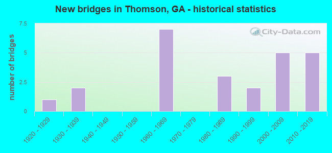
- New bridges - historical statistics
- 11920-1929
- 21930-1939
- 71960-1969
- 31980-1989
- 21990-1999
- 52000-2009
- 52010-2019

- Reconstructed bridges - Historical Statistics
- 11950-1959
- 01960-1969
- 11970-1979


- Bridge Condition - Deck
- 5.9%Very good
- 82.4%Good
- 11.8%Satisfactory

- Bridge Condition - Superstructure
- 58.8%Very good
- 35.3%Good
- 5.9%Satisfactory

- Bridge Condition - Substructure
- 23.5%Very good
- 47.1%Good
- 29.4%Satisfactory

- Bridge Condition - Channel
- 37.5%Very good
- 25.0%Good
- 37.5%Satisfactory

- Bridge Condition - Culverts
- 62.5%Good
- 37.5%Satisfactory
Find on map >> Show street view
Structure Number: 1890004, Location: 3.6 MI SE OF THOMSON (Lat: 33.438269, Lng: -82.450628), Route carried "on" structure: US 78, Year Built: 1931, Year Reconstructed: 1957, Status: Open, Structure Length: 2.19m (7.19ft), Average Daily Traffic: 4,420 (year 2011), Truck Traffic: 1%, Average Future Daily Traffic: 6,630 (year 2031), Design Load: H 15, Features Intersected: SWEETWATER CREEK
Minimum Vertical Clearance: 30+ m (98+ ft), Kilometerpoint: 28.968, Lanes on structure: 2, Base Highway Network: Yes, Owner: State Highway Agency, Approaching Roadway Width: 9.1m (29.9ft), Material/Design: Concrete, Design/Construction: Tee Beam, Number Of Spans In Main Unit: 3, Length of Maximum Span: 7.3m (24.0ft), Curb or Sidewalk Widths: Left: 0.6m (2.0ft), Right: 0.6m (2.0ft), Curb-To-Curb Width: 8.5m (27.9ft), Out-to-Out Width: 10.4m (34.1ft)
Condition: Deck: Satisfactory, Superstructure: Satisfactory, Substructure: Satisfactory, Channel: Good, Operating Rating: 36.2 metric tons, Method Used To Determine Operating Rating: Load Factor (LF), Inventory Rating: 21.7 metric tons, Method Used To Determine Inventory Rating: Load Factor (LF), Structural Evaluation: Somewhat better than minimum adequacy, Deck Geometry: Meets minimum limits, Waterway Adequacy: Equal to present desirable criteria, Approach Roadway Alignment: Equal to present desirable criteria, Length Of Structure Improvement: 8.63m (28.31ft), Designated Inspection Frequency: Every 24 months, Inspection Date: January 2021, Bridge Improvement Cost: $281,000, Roadway Improvement Cost: $28,000, Total Project Cost: $422,000, Deck Structure Type: Concrete Cast-file-Place, Wearing Surface/Protective System: Wearing Surface: Bituminous
Find on map >> Show street view
Structure Number: 1890005, Location: 4.3 MI SE OF THOMSON (Lat: 33.431156, Lng: -82.440986), Route carried "on" structure: US 78, Year Built: 1928, Year Reconstructed: 1982, Status: Open, Structure Length: 0.91m (2.99ft), Average Daily Traffic: 4,420 (year 2011), Truck Traffic: 1%, Average Future Daily Traffic: 6,630 (year 2031), Design Load: H 15, Features Intersected: SWEETWATER CREEK TRIB
Minimum Vertical Clearance: 30+ m (98+ ft), Kilometerpoint: 30.578, Lanes on structure: 3, Base Highway Network: Yes, Owner: State Highway Agency, Approaching Roadway Width: 12.5m (41.0ft), Skew: 4 degrees, Material/Design: Concrete, Design/Construction: Culvert, Number Of Spans In Main Unit: 2, Length of Maximum Span: 4.3m (14.1ft)
Condition: Channel: Satisfactory, Culverts: Good, Operating Rating: 59.8 metric tons, Method Used To Determine Operating Rating: Load Factor (LF), Inventory Rating: 36.2 metric tons, Method Used To Determine Inventory Rating: Load Factor (LF), Structural Evaluation: Better than present minimum criteria, Waterway Adequacy: Equal to present desirable criteria, Approach Roadway Alignment: Equal to present desirable criteria, Designated Inspection Frequency: Every 24 months, Inspection Date: January 2021, Bridge Improvement Cost: $149,000, Roadway Improvement Cost: $15,000, Total Project Cost: $224,000
Find on map >> Show street view
Structure Number: 1890008, Location: 3.7 MI NE OF THOMSON (Lat: 33.514158, Lng: -82.477008), Route carried "on" structure: County highway 24, Year Built: 1966, Status: Open, Structure Length: 6.40m (21.00ft), Average Daily Traffic: 370 (year 2011), Truck Traffic: 1%, Average Future Daily Traffic: 555 (year 2031), Design Load: H 15, Features Intersected: I-20, Facility Carried by Structure: SCUFFEL ROAD
Minimum Vertical Clearance: 30+ m (98+ ft), Kilometerpoint: 1.609, Lanes on structure: 2, Lanes under structure: 4, Base Highway Network: Yes, Owner: State Highway Agency, Approaching Roadway Width: 6.1m (20.0ft), Material/Design: Steel, Design/Construction: Stringer/Multi-beam, Number Of Spans In Main Unit: 4, Length of Maximum Span: 21.3m (69.9ft), Curb or Sidewalk Widths: Left: 0.6m (2.0ft), Right: 0.6m (2.0ft), Curb-To-Curb Width: 7.3m (24.0ft), Out-to-Out Width: 9.2m (30.2ft)
Condition: Deck: Good, Superstructure: Good, Substructure: Satisfactory, Operating Rating: 41.7 metric tons, Method Used To Determine Operating Rating: Load Factor (LF), Inventory Rating: 24.4 metric tons, Method Used To Determine Inventory Rating: Load Factor (LF), Structural Evaluation: Equal to present minimum criteria, Deck Geometry: Somewhat better than minimum adequacy, Underclear: High priority of corrective action, Approach Roadway Alignment: Equal to present desirable criteria, Designated Inspection Frequency: Every 24 months, Inspection Date: January 2021, Bridge Improvement Cost: $821,000, Roadway Improvement Cost: $82,000, Total Project Cost: $1,231,000, Deck Structure Type: Concrete Cast-file-Place
Find on map >> Show street view
Structure Number: 1890012, Location: 4 MI NE OF THOMSON (Lat: 33.506478, Lng: -82.453644), Route carried "on" structure: State highway 150, Year Built: 1983, Status: Open, Structure Length: 1.68m (5.51ft), Average Daily Traffic: 5,350 (year 2011), Truck Traffic: 6%, Average Future Daily Traffic: 8,025 (year 2031), Design Load: HS 20+Mod, Features Intersected: GERMANY CREEK
Minimum Vertical Clearance: 30+ m (98+ ft), Kilometerpoint: 6.437, Lanes on structure: 2, Base Highway Network: Yes, Owner: State Highway Agency, Approaching Roadway Width: 8.2m (26.9ft), Material/Design: Concrete, Design/Construction: Culvert, Number Of Spans In Main Unit: 5, Length of Maximum Span: 3.0m (9.8ft)
Condition: Channel: Satisfactory, Culverts: Satisfactory, Operating Rating: 55.3 metric tons, Method Used To Determine Operating Rating: Load Factor (LF), Inventory Rating: 32.6 metric tons, Method Used To Determine Inventory Rating: Load Factor (LF), Structural Evaluation: Equal to present minimum criteria, Waterway Adequacy: Equal to present desirable criteria, Approach Roadway Alignment: Equal to present desirable criteria, Designated Inspection Frequency: Every 24 months, Underwater Inspection Frequency: Every 60 months, Inspection Date: January 2021, Underwater Inspection Date: October 2021, Bridge Improvement Cost: $215,000, Roadway Improvement Cost: $21,000, Total Project Cost: $322,000
Find on map >> Show street view
Structure Number: 1890013, Location: 4.6 MI NE OF THOMSON (Lat: 33.511239, Lng: -82.446689), Route carried "on" structure: State highway 150, Year Built: 1966, Status: Open, Structure Length: 11.09m (36.38ft), Average Daily Traffic: 2,270 (year 2011), Truck Traffic: 1%, Average Future Daily Traffic: 3,405 (year 2031), Design Load: HS 20+Mod, Features Intersected: I-20
Minimum Vertical Clearance: 30+ m (98+ ft), Kilometerpoint: 8.047, Lanes on structure: 2, Lanes under structure: 4, Base Highway Network: Yes, Owner: State Highway Agency, Approaching Roadway Width: 7.3m (24.0ft), Material/Design: Steel continuous, Design/Construction: Stringer/Multi-beam, Number Of Spans In Main Unit: 4, Length of Maximum Span: 29.6m (97.1ft), Curb or Sidewalk Widths: Left: 0.6m (2.0ft), Right: 0.6m (2.0ft), Curb-To-Curb Width: 8.5m (27.9ft), Out-to-Out Width: 10.5m (34.4ft)
Condition: Deck: Good, Superstructure: Good, Substructure: Good, Operating Rating: 63.5 metric tons, Method Used To Determine Operating Rating: Load Factor (LF), Inventory Rating: 38.1 metric tons, Method Used To Determine Inventory Rating: Load Factor (LF), Structural Evaluation: Better than present minimum criteria, Deck Geometry: Meets minimum limits, Underclear: High priority of corrective action, Approach Roadway Alignment: Equal to present desirable criteria, Designated Inspection Frequency: Every 24 months, Inspection Date: January 2021, Bridge Improvement Cost: $1,422,000, Roadway Improvement Cost: $142,000, Total Project Cost: $2,133,000, Deck Structure Type: Concrete Cast-file-Place, Wearing Surface/Protective System: Wearing Surface: Latex Concrete
Find on map >> Show street view
Structure Number: 1890016, Location: 2.7 MI NW OF THOMSON (Lat: 33.494758, Lng: -82.535558), Route carried "on" structure: State highway 223, Year Built: 1936, Status: Open, Structure Length: 1.31m (4.30ft), Average Daily Traffic: 450 (year 2011), Truck Traffic: 1%, Average Future Daily Traffic: 675 (year 2031), Design Load: H 15, Features Intersected: MATTOX CREEK
Minimum Vertical Clearance: 30+ m (98+ ft), Kilometerpoint: 6.437, Lanes on structure: 2, Base Highway Network: Yes, Owner: State Highway Agency, Approaching Roadway Width: 7.3m (24.0ft), Material/Design: Concrete, Design/Construction: Culvert, Number Of Spans In Main Unit: 4, Length of Maximum Span: 3.0m (9.8ft)
Condition: Channel: Satisfactory, Culverts: Good, Operating Rating: 41.7 metric tons, Method Used To Determine Operating Rating: Field evaluation and documented engineering judgment, Inventory Rating: 24.4 metric tons, Method Used To Determine Inventory Rating: Field evaluation and documented engineering judgment, Structural Evaluation: Equal to present minimum criteria, Waterway Adequacy: Equal to present desirable criteria, Approach Roadway Alignment: Equal to present desirable criteria, Designated Inspection Frequency: Every 24 months, Inspection Date: January 2021, Bridge Improvement Cost: $168,000, Roadway Improvement Cost: $17,000, Total Project Cost: $252,000
Find on map >> Show street view
Structure Number: 1890018, Location: 3.4 MI NW OF THOMSON (Lat: 33.507619, Lng: -82.534417), Route carried "on" structure: Interstate 20, Year Built: 1968, Status: Open, Structure Length: 0.98m (3.22ft), Average Daily Traffic: 24,490 (year 2011), Truck Traffic: 1%, Average Future Daily Traffic: 36,735 (year 2031), Design Load: HS 20+Mod, Features Intersected: MATTOX CREEK
Minimum Vertical Clearance: 30+ m (98+ ft), Kilometerpoint: 273.589, Lanes on structure: 2, Base Highway Network: Yes, Owner: State Highway Agency, Approaching Roadway Width: 23.2m (76.1ft), Skew: 10 degrees, Material/Design: Concrete, Design/Construction: Culvert, Number Of Spans In Main Unit: 3, Length of Maximum Span: 3.0m (9.8ft)
Condition: Channel: Good, Culverts: Satisfactory, Structural Evaluation: Equal to present minimum criteria, Waterway Adequacy: Equal to present desirable criteria, Approach Roadway Alignment: Equal to present desirable criteria, Designated Inspection Frequency: Every 24 months, Inspection Date: January 2021, Bridge Improvement Cost: $125,000, Roadway Improvement Cost: $13,000, Total Project Cost: $188,000
Find on map >> Show street view
Structure Number: 1890019, Location: 4.1 MI NE OF THOMSON (Lat: 33.512339, Lng: -82.458558), Route carried "on" structure: Interstate 20, Year Built: 1966, Status: Open, Structure Length: 2.93m (9.61ft), Average Daily Traffic: 28,780 (year 2011), Truck Traffic: 1%, Average Future Daily Traffic: 43,170 (year 2031), Design Load: HS 20+Mod, Features Intersected: GERMANY CREEK
Minimum Vertical Clearance: 30+ m (98+ ft), Kilometerpoint: 280.026, Lanes on structure: 2, Base Highway Network: Yes, Owner: State Highway Agency, Approaching Roadway Width: 12.2m (40.0ft), Skew: 10 degrees, Material/Design: Concrete, Design/Construction: Tee Beam, Number Of Spans In Main Unit: 3, Length of Maximum Span: 9.8m (32.2ft), Curb-To-Curb Width: 11.6m (38.1ft), Out-to-Out Width: 12.3m (40.4ft)
Condition: Deck: Good, Superstructure: Good, Substructure: Good, Channel: Good, Operating Rating: 51.7 metric tons, Method Used To Determine Operating Rating: Load Factor (LF), Inventory Rating: 30.8 metric tons, Method Used To Determine Inventory Rating: Load Factor (LF), Structural Evaluation: Better than present minimum criteria, Deck Geometry: Equal to present minimum criteria, Waterway Adequacy: Equal to present desirable criteria, Approach Roadway Alignment: Equal to present desirable criteria, Designated Inspection Frequency: Every 24 months, Inspection Date: January 2021, Bridge Improvement Cost: $375,000, Roadway Improvement Cost: $38,000, Total Project Cost: $563,000, Deck Structure Type: Concrete Cast-file-Place
Find on map >> Show street view
Structure Number: 189002, Location: 4.1 MI NE OF THOMSON (Lat: 33.512594, Lng: -82.458550), Route carried "on" structure: Interstate 20, Year Built: 1966, Status: Open, Structure Length: 2.93m (9.61ft), Average Daily Traffic: 28,780 (year 2011), Truck Traffic: 1%, Average Future Daily Traffic: 43,170 (year 2031), Design Load: HS 20+Mod, Features Intersected: GERMANY CREEK
Minimum Vertical Clearance: 30+ m (98+ ft), Kilometerpoint: 281.635, Lanes on structure: 2, Base Highway Network: Yes, Owner: State Highway Agency, Approaching Roadway Width: 12.2m (40.0ft), Skew: 10 degrees, Material/Design: Concrete, Design/Construction: Tee Beam, Number Of Spans In Main Unit: 3, Length of Maximum Span: 9.8m (32.2ft), Curb-To-Curb Width: 11.6m (38.1ft), Out-to-Out Width: 12.3m (40.4ft)
Condition: Deck: Good, Superstructure: Good, Substructure: Good, Channel: Good, Operating Rating: 51.7 metric tons, Method Used To Determine Operating Rating: Load Factor (LF), Inventory Rating: 30.8 metric tons, Method Used To Determine Inventory Rating: Load Factor (LF), Structural Evaluation: Better than present minimum criteria, Deck Geometry: Equal to present minimum criteria, Waterway Adequacy: Equal to present desirable criteria, Approach Roadway Alignment: Equal to present desirable criteria, Designated Inspection Frequency: Every 24 months, Inspection Date: January 2021, Bridge Improvement Cost: $375,000, Roadway Improvement Cost: $38,000, Total Project Cost: $563,000, Deck Structure Type: Concrete Cast-file-Place
Find on map >> Show street view
Structure Number: 1890026, Location: 3.2 MI N OF THOMSON (Lat: 33.509158, Lng: -82.521728), Route carried "on" structure: County highway 2150, Year Built: 1968, Status: Open, Structure Length: 9.05m (29.69ft), Average Daily Traffic: 310 (year 2011), Truck Traffic: 1%, Average Future Daily Traffic: 465 (year 2031), Design Load: HS 15, Features Intersected: I-20, Facility Carried by Structure: WRIGHTSBORO ROAD
Minimum Vertical Clearance: 30+ m (98+ ft), Kilometerpoint: 0.000, Lanes on structure: 2, Lanes under structure: 4, Base Highway Network: Yes, Owner: State Highway Agency, Approaching Roadway Width: 5.5m (18.0ft), Skew: 2 degrees, Material/Design: Steel continuous, Design/Construction: Stringer/Multi-beam, Number Of Spans In Main Unit: 4, Length of Maximum Span: 24.4m (80.1ft), Curb or Sidewalk Widths: Left: 0.6m (2.0ft), Right: 0.6m (2.0ft), Curb-To-Curb Width: 7.9m (25.9ft), Out-to-Out Width: 10.0m (32.8ft)
Condition: Deck: Satisfactory, Superstructure: Good, Substructure: Satisfactory, Operating Rating: 58.0 metric tons, Method Used To Determine Operating Rating: Load Factor (LF), Inventory Rating: 34.4 metric tons, Method Used To Determine Inventory Rating: Load Factor (LF), Structural Evaluation: Equal to present minimum criteria, Deck Geometry: Somewhat better than minimum adequacy, Underclear: Equal to present minimum criteria, Approach Roadway Alignment: Equal to present minimum criteria, Designated Inspection Frequency: Every 24 months, Inspection Date: January 2021, Bridge Improvement Cost: $1,160,000, Roadway Improvement Cost: $116,000, Total Project Cost: $1,741,000, Deck Structure Type: Concrete Cast-file-Place
Find on map >> Show street view
Structure Number: 1890029, Location: 4.5 MI SE OF THOMSON (Lat: 33.414928, Lng: -82.453228), Route carried "on" structure: County highway 2543, Year Built: 1964, Status: Open, Structure Length: 1.10m (3.61ft), Average Daily Traffic: 1,110 (year 2011), Truck Traffic: 1%, Average Future Daily Traffic: 1,665 (year 2031), Design Load: H 15, Features Intersected: SWEETWATER CREEK, Facility Carried by Structure: WIRE ROAD
Minimum Vertical Clearance: 30+ m (98+ ft), Kilometerpoint: 9.656, Lanes on structure: 2, Base Highway Network: Yes, Owner: County Highway Agency, Approaching Roadway Width: 6.7m (22.0ft), Skew: 2 degrees, Material/Design: Concrete, Design/Construction: Culvert, Number Of Spans In Main Unit: 3, Length of Maximum Span: 3.4m (11.2ft)
Condition: Channel: Satisfactory, Culverts: Good, Operating Rating: 41.7 metric tons, Method Used To Determine Operating Rating: Field evaluation and documented engineering judgment, Inventory Rating: 24.4 metric tons, Method Used To Determine Inventory Rating: Field evaluation and documented engineering judgment, Structural Evaluation: Equal to present minimum criteria, Waterway Adequacy: Equal to present desirable criteria, Approach Roadway Alignment: Equal to present desirable criteria, Designated Inspection Frequency: Every 24 months, Inspection Date: January 2021, Bridge Improvement Cost: $141,000, Roadway Improvement Cost: $14,000, Total Project Cost: $211,000
Find on map >> Show street view
Structure Number: 1895006, Location: 3.6 MI SW OF THOMSON (Lat: 33.413939, Lng: -82.506747), Route carried "on" structure: County highway 124, Year Built: 1980, Status: Open, Structure Length: 1.31m (4.30ft), Average Daily Traffic: 300 (year 2011), Truck Traffic: 1%, Average Future Daily Traffic: 450 (year 2031), Design Load: HS 20+Mod, Features Intersected: WHITES CREEK, Facility Carried by Structure: OLD MILLEDGEVILLE
Minimum Vertical Clearance: 30+ m (98+ ft), Kilometerpoint: 8.047, Lanes on structure: 2, Base Highway Network: Yes, Owner: County Highway Agency, Approaching Roadway Width: 6.4m (21.0ft), Material/Design: Concrete, Design/Construction: Culvert, Number Of Spans In Main Unit: 4, Length of Maximum Span: 3.0m (9.8ft)
Condition: Channel: Satisfactory, Culverts: Good, Operating Rating: 55.3 metric tons, Method Used To Determine Operating Rating: Field evaluation and documented engineering judgment, Inventory Rating: 32.6 metric tons, Method Used To Determine Inventory Rating: Field evaluation and documented engineering judgment, Structural Evaluation: Better than present minimum criteria, Waterway Adequacy: Equal to present desirable criteria, Approach Roadway Alignment: Equal to present desirable criteria, Designated Inspection Frequency: Every 24 months, Inspection Date: January 2021, Bridge Improvement Cost: $168,000, Roadway Improvement Cost: $17,000, Total Project Cost: $252,000
Find on map >> Show street view
Structure Number: 1895009, Location: 4.7 MI NE OF THOMSON (Lat: 33.531847, Lng: -82.485689), Route carried "on" structure: County highway 8, Year Built: 1984, Status: Open, Structure Length: 0.70m (2.30ft), Average Daily Traffic: 300 (year 2011), Truck Traffic: 1%, Average Future Daily Traffic: 450 (year 2031), Design Load: HS 20+Mod, Features Intersected: LITTLE GERMANY CREEK, Facility Carried by Structure: STAGECOACH RD
Minimum Vertical Clearance: 30+ m (98+ ft), Kilometerpoint: 6.437, Lanes on structure: 2, Base Highway Network: Yes, Owner: County Highway Agency, Approaching Roadway Width: 6.1m (20.0ft), Material/Design: Concrete, Design/Construction: Culvert, Number Of Spans In Main Unit: 3, Length of Maximum Span: 2.1m (6.9ft)
Condition: Channel: Satisfactory, Culverts: Satisfactory, Operating Rating: 55.3 metric tons, Method Used To Determine Operating Rating: Field evaluation and documented engineering judgment, Inventory Rating: 32.6 metric tons, Method Used To Determine Inventory Rating: Field evaluation and documented engineering judgment, Structural Evaluation: Equal to present minimum criteria, Waterway Adequacy: Equal to present desirable criteria, Approach Roadway Alignment: Equal to present desirable criteria, Designated Inspection Frequency: Every 24 months, Inspection Date: January 2021, Bridge Improvement Cost: $90,000, Roadway Improvement Cost: $9,000, Total Project Cost: $135,000
Find on map >> Show street view
Structure Number: 1895014, Location: 4.5 MI N OF THOMSON (Lat: 33.527128, Lng: -82.531736), Route carried "on" structure: County highway 2150, Year Built: 1996, Status: Open, Structure Length: 1.86m (6.10ft), Average Daily Traffic: 310 (year 2011), Truck Traffic: 1%, Average Future Daily Traffic: 465 (year 2031), Design Load: HS 20+Mod, Features Intersected: MATTOX CREEK, Facility Carried by Structure: WRIGHTSBORO ROAD
Minimum Vertical Clearance: 30+ m (98+ ft), Kilometerpoint: 3.219, Lanes on structure: 2, Base Highway Network: Yes, Owner: County Highway Agency, Approaching Roadway Width: 6.7m (22.0ft), Skew: 4 degrees, Material/Design: Concrete, Design/Construction: Culvert, Number Of Spans In Main Unit: 4, Length of Maximum Span: 4.3m (14.1ft)
Condition: Channel: Very good, Culverts: Good, Operating Rating: 55.3 metric tons, Method Used To Determine Operating Rating: Field evaluation and documented engineering judgment, Inventory Rating: 32.6 metric tons, Method Used To Determine Inventory Rating: Field evaluation and documented engineering judgment, Structural Evaluation: Better than present minimum criteria, Waterway Adequacy: Equal to present desirable criteria, Approach Roadway Alignment: Equal to present minimum criteria, Designated Inspection Frequency: Every 24 months, Inspection Date: January 2021, Bridge Improvement Cost: $238,000, Roadway Improvement Cost: $24,000, Total Project Cost: $358,000
Find on map >> Show street view
Structure Number: 1895016, Location: 3 MI N OF THOMSON (Lat: 33.511339, Lng: -82.502250), Route carried "on" structure: US 78, Year Built: 1999, Status: Open, Structure Length: 8.44m (27.69ft), Average Daily Traffic: 4,120 (year 2011), Truck Traffic: 1%, Average Future Daily Traffic: 6,180 (year 2031), Design Load: HS 20+Mod, Features Intersected: I-20
Minimum Vertical Clearance: 30+ m (98+ ft), Kilometerpoint: 17.703, Lanes on structure: 6, Lanes under structure: 4, Base Highway Network: Yes, Owner: State Highway Agency, Approaching Roadway Width: 19.5m (64.0ft), Material/Design: Prestressed concrete, Design/Construction: Stringer/Multi-beam, Number Of Spans In Main Unit: 4, Length of Maximum Span: 27.4m (89.9ft), Curb-To-Curb Width: 28.0m (91.9ft), Out-to-Out Width: 28.9m (94.8ft)
Condition: Deck: Good, Superstructure: Good, Substructure: Good, Operating Rating: 62.5 metric tons, Method Used To Determine Operating Rating: Load Factor (LF), Inventory Rating: 28.1 metric tons, Method Used To Determine Inventory Rating: Load Factor (LF), Structural Evaluation: Better than present minimum criteria, Deck Geometry: Superior to present desirable criteria, Underclear: Better than present minimum criteria, Approach Roadway Alignment: Equal to present desirable criteria, Designated Inspection Frequency: Every 24 months, Inspection Date: January 2021, Bridge Improvement Cost: $2,263,000, Roadway Improvement Cost: $226,000, Total Project Cost: $3,394,000, Deck Structure Type: Concrete Cast-file-Place
Find on map >> Show street view
Structure Number: 1895017, Location: 3 MI W OF THOMSON (Lat: 33.474761, Lng: -82.551492), Route carried "on" structure: County highway 445, Year Built: 2000, Status: Open, Structure Length: 9.45m (31.00ft), Average Daily Traffic: 250 (year 2011), Truck Traffic: 1%, Average Future Daily Traffic: 375 (year 2031), Design Load: HS 20+Mod, Features Intersected: CR 166 & MATTOX CREEK, Facility Carried by Structure: W THOMSON BYPASS
Minimum Vertical Clearance: 30+ m (98+ ft), Kilometerpoint: 3.219, Lanes on structure: 2, Lanes under structure: 2, Base Highway Network: Yes, Owner: County Highway Agency, Approaching Roadway Width: 7.3m (24.0ft), Skew: 1 degrees, Material/Design: Prestressed concrete, Design/Construction: Stringer/Multi-beam, Number Of Spans In Main Unit: 4, Length of Maximum Span: 26.2m (86.0ft), Curb-To-Curb Width: 12.2m (40.0ft), Out-to-Out Width: 13.2m (43.3ft)
Condition: Deck: Good, Superstructure: Very good, Substructure: Good, Channel: Very good, Operating Rating: 54.4 metric tons, Method Used To Determine Operating Rating: Load Factor (LF), Inventory Rating: 32.6 metric tons, Method Used To Determine Inventory Rating: Load Factor (LF), Structural Evaluation: Better than present minimum criteria, Deck Geometry: Superior to present desirable criteria, Underclear: Meets minimum limits, Waterway Adequacy: Equal to present desirable criteria, Approach Roadway Alignment: Equal to present minimum criteria, Designated Inspection Frequency: Every 24 months, Inspection Date: January 2021, Bridge Improvement Cost: $1,211,000, Roadway Improvement Cost: $121,000, Total Project Cost: $1,817,000, Deck Structure Type: Concrete Cast-file-Place
Find on map >> Show street view
Structure Number: 1895019, Location: 3.8 MI NE OF THOMSON (Lat: 33.511872, Lng: -82.498247), Route carried "on" structure: US 78, Year Built: 2010, Status: Open, Structure Length: 10.55m (34.61ft), Average Daily Traffic: 4,150 (year 2011), Truck Traffic: 1%, Average Future Daily Traffic: 6,225 (year 2031), Design Load: HS 20+Mod, Features Intersected: I-20
Minimum Vertical Clearance: 5.18m (16.99ft), Kilometerpoint: 17.703, Lanes on structure: 2, Lanes under structure: 6, Base Highway Network: Yes, Owner: State Highway Agency, Approaching Roadway Width: 10.4m (34.1ft), Skew: 10 degrees, Material/Design: Prestressed concrete, Design/Construction: Stringer/Multi-beam, Number Of Spans In Main Unit: 4, Length of Maximum Span: 39.0m (128.0ft), Curb-To-Curb Width: 11.6m (38.1ft), Out-to-Out Width: 12.6m (41.3ft)
Condition: Deck: Good, Superstructure: Very good, Substructure: Good, Operating Rating: 70.7 metric tons, Method Used To Determine Operating Rating: Load Factor (LF), Inventory Rating: 32.6 metric tons, Method Used To Determine Inventory Rating: Load Factor (LF), Structural Evaluation: Better than present minimum criteria, Deck Geometry: Better than present minimum criteria, Underclear: High priority of corrective action, Approach Roadway Alignment: Equal to present desirable criteria, Designated Inspection Frequency: Every 24 months, Inspection Date: January 2021, Bridge Improvement Cost: $1,352,000, Roadway Improvement Cost: $135,000, Total Project Cost: $2,028,000, Deck Structure Type: Concrete Cast-file-Place
Find on map >> Show street view
Structure Number: 189502, Location: 3.8 MI NE OF THOMSON (Lat: 33.512000, Lng: -82.498519), Route carried "on" structure: US 78, Year Built: 2010, Status: Open, Structure Length: 10.55m (34.61ft), Average Daily Traffic: 4,150 (year 2011), Truck Traffic: 1%, Average Future Daily Traffic: 6,225 (year 2031), Design Load: HS 20+Mod, Features Intersected: I-20
Minimum Vertical Clearance: 5.18m (16.99ft), Kilometerpoint: 17.703, Lanes on structure: 2, Lanes under structure: 5, Base Highway Network: Yes, Owner: State Highway Agency, Approaching Roadway Width: 9.8m (32.2ft), Skew: 10 degrees, Material/Design: Prestressed concrete, Design/Construction: Stringer/Multi-beam, Number Of Spans In Main Unit: 4, Length of Maximum Span: 39.0m (128.0ft), Curb-To-Curb Width: 11.6m (38.1ft), Out-to-Out Width: 12.6m (41.3ft)
Condition: Deck: Good, Superstructure: Very good, Substructure: Good, Operating Rating: 70.7 metric tons, Method Used To Determine Operating Rating: Load Factor (LF), Inventory Rating: 32.6 metric tons, Method Used To Determine Inventory Rating: Load Factor (LF), Structural Evaluation: Better than present minimum criteria, Deck Geometry: Better than present minimum criteria, Underclear: High priority of corrective action, Approach Roadway Alignment: Equal to present desirable criteria, Designated Inspection Frequency: Every 24 months, Inspection Date: January 2021, Bridge Improvement Cost: $1,352,000, Roadway Improvement Cost: $135,000, Total Project Cost: $2,028,000, Deck Structure Type: Concrete Cast-file-Place
Find on map >> Show street view
Structure Number: 1895021, Location: 0.8 MI NE OF THOMSON (Lat: 33.464408, Lng: -82.472814), Route carried "on" structure: US 78, Year Built: 2009, Status: Open, Structure Length: 8.66m (28.41ft), Average Daily Traffic: 4,150 (year 2011), Truck Traffic: 1%, Average Future Daily Traffic: 6,225 (year 2031), Design Load: HS 20+Mod, Features Intersected: TEMPLE RD - CSX RR
Minimum Vertical Clearance: 5.18m (16.99ft), Kilometerpoint: 24.140, Lanes on structure: 2, Lanes under structure: 2, Base Highway Network: Yes, Owner: State Highway Agency, Approaching Roadway Width: 10.4m (34.1ft), Skew: 14 degrees, Material/Design: Prestressed concrete, Design/Construction: Stringer/Multi-beam, Number Of Spans In Main Unit: 3, Length of Maximum Span: 43.0m (141.1ft), Curb-To-Curb Width: 15.2m (49.9ft), Out-to-Out Width: 16.2m (53.1ft)
Condition: Deck: Good, Superstructure: Very good, Substructure: Satisfactory, Operating Rating: 78.0 metric tons, Method Used To Determine Operating Rating: Load Factor (LF), Inventory Rating: 46.2 metric tons, Method Used To Determine Inventory Rating: Load Factor (LF), Structural Evaluation: Equal to present minimum criteria, Deck Geometry: Superior to present desirable criteria, Underclear: Superior to present desirable criteria, Approach Roadway Alignment: Equal to present desirable criteria, Designated Inspection Frequency: Every 24 months, Inspection Date: January 2021, Bridge Improvement Cost: $1,110,000, Roadway Improvement Cost: $111,000, Total Project Cost: $1,664,000, Deck Structure Type: Concrete Cast-file-Place
Find on map >> Show street view
Structure Number: 1895022, Location: 0.8 MI NE OF THOMSON (Lat: 33.464411, Lng: -82.473097), Route carried "on" structure: US 78, Year Built: 2009, Status: Open, Structure Length: 8.66m (28.41ft), Average Daily Traffic: 4,150 (year 2011), Truck Traffic: 1%, Average Future Daily Traffic: 6,225 (year 2031), Design Load: HS 20+Mod, Features Intersected: TEMPLE RD - CSX RR
Minimum Vertical Clearance: 5.18m (16.99ft), Kilometerpoint: 24.140, Lanes on structure: 2, Lanes under structure: 2, Base Highway Network: Yes, Owner: State Highway Agency, Approaching Roadway Width: 10.4m (34.1ft), Skew: 14 degrees, Material/Design: Prestressed concrete, Design/Construction: Stringer/Multi-beam, Number Of Spans In Main Unit: 3, Length of Maximum Span: 43.0m (141.1ft), Curb-To-Curb Width: 15.2m (49.9ft), Out-to-Out Width: 16.2m (53.1ft)
Condition: Deck: Very good, Superstructure: Very good, Substructure: Satisfactory, Operating Rating: 69.8 metric tons, Method Used To Determine Operating Rating: Load Factor (LF), Inventory Rating: 34.4 metric tons, Method Used To Determine Inventory Rating: Load Factor (LF), Structural Evaluation: Equal to present minimum criteria, Deck Geometry: Superior to present desirable criteria, Underclear: Superior to present desirable criteria, Approach Roadway Alignment: Equal to present desirable criteria, Designated Inspection Frequency: Every 24 months, Inspection Date: January 2021, Bridge Improvement Cost: $1,110,000, Roadway Improvement Cost: $111,000, Total Project Cost: $1,664,000, Deck Structure Type: Concrete Cast-file-Place
Find on map >> Show street view
Structure Number: 1895023, Location: 0.6 MI NE OF THOMSON (Lat: 33.483939, Lng: -82.484092), Route carried "on" structure: State highway 10, Year Built: 2010, Status: Open, Structure Length: 3.23m (10.60ft), Average Daily Traffic: 4,150 (year 2011), Truck Traffic: 1%, Average Future Daily Traffic: 6,225 (year 2031), Design Load: HS 20+Mod, Features Intersected: SILLS BRANCH
Minimum Vertical Clearance: 30+ m (98+ ft), Kilometerpoint: 20.921, Lanes on structure: 2, Base Highway Network: Yes, Owner: State Highway Agency, Approaching Roadway Width: 10.4m (34.1ft), Skew: 10 degrees, Material/Design: Prestressed concrete, Design/Construction: Stringer/Multi-beam, Number Of Spans In Main Unit: 1, Length of Maximum Span: 32.3m (106.0ft), Curb-To-Curb Width: 11.6m (38.1ft), Out-to-Out Width: 12.6m (41.3ft)
Condition: Deck: Good, Superstructure: Very good, Substructure: Very good, Channel: Very good, Operating Rating: 76.2 metric tons, Method Used To Determine Operating Rating: Load Factor (LF), Inventory Rating: 45.3 metric tons, Method Used To Determine Inventory Rating: Load Factor (LF), Structural Evaluation: Equal to present desirable criteria, Deck Geometry: Better than present minimum criteria, Waterway Adequacy: Equal to present desirable criteria, Approach Roadway Alignment: Equal to present desirable criteria, Designated Inspection Frequency: Every 24 months, Inspection Date: January 2021, Bridge Improvement Cost: $414,000, Roadway Improvement Cost: $41,000, Total Project Cost: $621,000, Deck Structure Type: Concrete Cast-file-Place
Find on map >> Show street view
Structure Number: 1895024, Location: 0.6 MI NE OF THOMSON (Lat: 33.483733, Lng: -82.484078), Route carried "on" structure: State highway 10, Year Built: 2010, Status: Open, Structure Length: 3.23m (10.60ft), Average Daily Traffic: 4,150 (year 2011), Truck Traffic: 1%, Average Future Daily Traffic: 6,225 (year 2031), Design Load: HS 20+Mod, Features Intersected: SILLS BRANCH
Minimum Vertical Clearance: 30+ m (98+ ft), Kilometerpoint: 20.921, Lanes on structure: 2, Base Highway Network: Yes, Owner: State Highway Agency, Approaching Roadway Width: 10.4m (34.1ft), Skew: 10 degrees, Material/Design: Prestressed concrete, Design/Construction: Stringer/Multi-beam, Number Of Spans In Main Unit: 1, Length of Maximum Span: 32.3m (106.0ft), Curb-To-Curb Width: 11.6m (38.1ft), Out-to-Out Width: 12.6m (41.3ft)
Condition: Deck: Good, Superstructure: Very good, Substructure: Very good, Channel: Very good, Operating Rating: 76.2 metric tons, Method Used To Determine Operating Rating: Load Factor (LF), Inventory Rating: 39.9 metric tons, Method Used To Determine Inventory Rating: Load Factor (LF), Structural Evaluation: Equal to present desirable criteria, Deck Geometry: Better than present minimum criteria, Waterway Adequacy: Equal to present desirable criteria, Approach Roadway Alignment: Equal to present desirable criteria, Designated Inspection Frequency: Every 24 months, Inspection Date: January 2021, Bridge Improvement Cost: $414,000, Roadway Improvement Cost: $41,000, Total Project Cost: $621,000, Deck Structure Type: Concrete Cast-file-Place
Find on map >> Show street view
Structure Number: 1895025, Location: 1.2 MI NE OF THOMSON (Lat: 33.469217, Lng: -82.468928), Route carried "on" structure: US 78, Year Built: 2009, Status: Open, Structure Length: 2.59m (8.50ft), Average Daily Traffic: 4,150 (year 2011), Truck Traffic: 1%, Average Future Daily Traffic: 6,225 (year 2031), Design Load: HS 20+Mod, Features Intersected: DANLEY BRANCH
Minimum Vertical Clearance: 30+ m (98+ ft), Kilometerpoint: 24.140, Lanes on structure: 2, Base Highway Network: Yes, Owner: State Highway Agency, Approaching Roadway Width: 10.4m (34.1ft), Skew: 10 degrees, Material/Design: Prestressed concrete, Design/Construction: Stringer/Multi-beam, Number Of Spans In Main Unit: 1, Length of Maximum Span: 25.9m (85.0ft), Curb-To-Curb Width: 11.6m (38.1ft), Out-to-Out Width: 12.6m (41.3ft)
Condition: Deck: Good, Superstructure: Very good, Substructure: Very good, Channel: Very good, Operating Rating: 71.6 metric tons, Method Used To Determine Operating Rating: Load Factor (LF), Inventory Rating: 38.1 metric tons, Method Used To Determine Inventory Rating: Load Factor (LF), Structural Evaluation: Equal to present desirable criteria, Deck Geometry: Better than present minimum criteria, Waterway Adequacy: Equal to present desirable criteria, Approach Roadway Alignment: Equal to present desirable criteria, Designated Inspection Frequency: Every 24 months, Inspection Date: January 2021, Bridge Improvement Cost: $332,000, Roadway Improvement Cost: $33,000, Total Project Cost: $498,000, Deck Structure Type: Concrete Cast-file-Place
Find on map >> Show street view
Structure Number: 1895026, Location: 0.2 MI NE OF THOMSON (Lat: 33.469250, Lng: -82.469167), Route carried "on" structure: US 78, Year Built: 2009, Status: Open, Structure Length: 2.59m (8.50ft), Average Daily Traffic: 4,150 (year 2011), Truck Traffic: 1%, Average Future Daily Traffic: 6,225 (year 2031), Design Load: HS 20+Mod, Features Intersected: DANLEY BRANCH
Minimum Vertical Clearance: 30+ m (98+ ft), Kilometerpoint: 24.140, Lanes on structure: 2, Base Highway Network: Yes, Owner: State Highway Agency, Approaching Roadway Width: 7.9m (25.9ft), Skew: 10 degrees, Material/Design: Prestressed concrete, Design/Construction: Stringer/Multi-beam, Number Of Spans In Main Unit: 1, Length of Maximum Span: 25.9m (85.0ft), Curb-To-Curb Width: 11.6m (38.1ft), Out-to-Out Width: 12.6m (41.3ft)
Condition: Deck: Good, Superstructure: Very good, Substructure: Very good, Channel: Very good, Operating Rating: 71.6 metric tons, Method Used To Determine Operating Rating: Load Factor (LF), Inventory Rating: 41.7 metric tons, Method Used To Determine Inventory Rating: Load Factor (LF), Structural Evaluation: Equal to present desirable criteria, Deck Geometry: Better than present minimum criteria, Waterway Adequacy: Superior to present desirable criteria, Approach Roadway Alignment: Equal to present desirable criteria, Designated Inspection Frequency: Every 24 months, Inspection Date: January 2021, Bridge Improvement Cost: $332,000, Roadway Improvement Cost: $33,000, Total Project Cost: $498,000, Deck Structure Type: Concrete Cast-file-Place
Find on map >> Show street view
Structure Number: 1895027, Location: 4.1 MI NW OF THOMSON (Lat: 33.505458, Lng: -82.555228), Route carried "on" structure: County highway 21, Year Built: 2012, Status: Open, Structure Length: 8.11m (26.61ft), Average Daily Traffic: 5,350 (year 2012), Truck Traffic: 5%, Average Future Daily Traffic: 8,850 (year 2032), Design Load: HS 20+Mod, Features Intersected: I-20, Facility Carried by Structure: THREE POINTS RD
Minimum Vertical Clearance: 30+ m (98+ ft), Kilometerpoint: 1.609, Lanes on structure: 2, Lanes under structure: 4, Base Highway Network: Yes, Owner: State Highway Agency, Approaching Roadway Width: 18.3m (60.0ft), Skew: 2 degrees, Material/Design: Prestressed concrete, Design/Construction: Stringer/Multi-beam, Number Of Spans In Main Unit: 4, Length of Maximum Span: 26.8m (87.9ft), Curb-To-Curb Width: 17.7m (58.1ft), Out-to-Out Width: 18.7m (61.4ft)
Condition: Deck: Good, Superstructure: Very good, Substructure: Good, Operating Rating: 67.1 metric tons, Method Used To Determine Operating Rating: Load Factor (LF), Inventory Rating: 42.6 metric tons, Method Used To Determine Inventory Rating: Load Factor (LF), Structural Evaluation: Better than present minimum criteria, Deck Geometry: Superior to present desirable criteria, Underclear: High priority of corrective action, Approach Roadway Alignment: Equal to present desirable criteria, Designated Inspection Frequency: Every 24 months, Inspection Date: January 2021, Bridge Improvement Cost: $1,039,000, Roadway Improvement Cost: $104,000, Total Project Cost: $1,559,000, Deck Structure Type: Concrete Cast-file-Place
Find on map >> Show street view
Structure Number: 1890008, Location: 3.7 MI NE OF THOMSON (Lat: 33.514158, Lng: -82.477008), Route carried "under" structure: Interstate 20, Structure Length: 0. m, Average Daily Traffic: 29,200 (year 2010), Truck Traffic: 2%, Features Intersected: CR 24 SCUFFEL ROAD, Facility Carried by Structure: SCUFFEL ROAD
Minimum Vertical Clearance: 5.94m (19.49ft), Kilometerpoint: 278.417, Lanes on structure: 2, Length of Maximum Span: 0.0m
Find on map >> Show street view
Structure Number: 1890013, Location: 4.6 MI NE OF THOMSON (Lat: 33.511239, Lng: -82.446689), Route carried "under" structure: Interstate 20, Structure Length: 0. m, Average Daily Traffic: 33,400 (year 2010), Truck Traffic: 8%, Features Intersected: SR 150, Facility Carried by Structure: SR 150
Minimum Vertical Clearance: 5.68m (18.64ft), Kilometerpoint: 281.635, Lanes on structure: 2, Length of Maximum Span: 0.0m
Find on map >> Show street view
Structure Number: 1890026, Location: 3.2 MI N OF THOMSON (Lat: 33.509158, Lng: -82.521728), Route carried "under" structure: Interstate 20, Structure Length: 0. m, Average Daily Traffic: 27,300 (year 2010), Truck Traffic: 8%, Features Intersected: S-2150 WRIGHTSBORO ROAD, Facility Carried by Structure: WRIGHTSBORO ROAD
Minimum Vertical Clearance: 5.20m (17.06ft), Kilometerpoint: 275.198, Lanes on structure: 2, Length of Maximum Span: 0.0m
Find on map >> Show street view
Structure Number: 1895016, Location: 3 MI N OF THOMSON (Lat: 33.511339, Lng: -82.502250), Route carried "under" structure: Interstate 20, Structure Length: 0. m, Average Daily Traffic: 29,200 (year 2010), Truck Traffic: 12%, Features Intersected: SR 10 (US 78), Facility Carried by Structure: US 78, SR 10
Minimum Vertical Clearance: 5.61m (18.41ft), Kilometerpoint: 276.807, Lanes on structure: 6, Length of Maximum Span: 0.0m
Find on map >> Show street view
Structure Number: 1895017, Location: 3 MI W OF THOMSON (Lat: 33.474761, Lng: -82.551492), Route carried "under" structure: County highway 166, Structure Length: 0. m, Average Daily Traffic: 90 (year 2010), Truck Traffic: 2%, Features Intersected: CR 445, Facility Carried by Structure: W THOMSON BYPASS
Minimum Vertical Clearance: 5.79m (19.00ft), Kilometerpoint: 0.000, Lanes on structure: 2, Length of Maximum Span: 0.0m
Find on map >> Show street view
Structure Number: 1895019, Location: 3.8 MI NE OF THOMSON (Lat: 33.511872, Lng: -82.498247), Route carried "under" structure: Interstate 20, Structure Length: 0. m, Average Daily Traffic: 11,100 (year 2010), Truck Traffic: 8%, Features Intersected: SR 10, Facility Carried by Structure: US 78, SR 10, SR 1
Minimum Vertical Clearance: 5.96m (19.55ft), Kilometerpoint: 276.807, Lanes on structure: 2, Length of Maximum Span: 0.0m
Find on map >> Show street view
Structure Number: 189502, Location: 3.8 MI NE OF THOMSON (Lat: 33.512000, Lng: -82.498519), Route carried "under" structure: Interstate 20, Structure Length: 0. m, Average Daily Traffic: 11,100 (year 2010), Truck Traffic: 8%, Features Intersected: SR 10, Facility Carried by Structure: US 78, SR 10, SR 1
Minimum Vertical Clearance: 5.86m (19.23ft), Kilometerpoint: 276.807, Lanes on structure: 2, Length of Maximum Span: 0.0m
Find on map >> Show street view
Structure Number: 1895021, Location: 0.8 MI NE OF THOMSON (Lat: 33.464408, Lng: -82.472814), Route carried "under" structure: County highway 409, Structure Length: 0. m, Average Daily Traffic: 100 (year 2010), Truck Traffic: 1%, Features Intersected: US 78, SR 10, S, Facility Carried by Structure: US 78, SR 10, SR 1
Minimum Vertical Clearance: 7.28m (23.88ft), Kilometerpoint: 0.000, Lanes on structure: 2, Length of Maximum Span: 0.0m
Find on map >> Show street view
Structure Number: 1895022, Location: 0.8 MI NE OF THOMSON (Lat: 33.464411, Lng: -82.473097), Route carried "under" structure: County highway 409, Structure Length: 0. m, Average Daily Traffic: 100 (year 2010), Truck Traffic: 1%, Features Intersected: US 78, SR 10, S, Facility Carried by Structure: US 78, SR 10, SR 1
Minimum Vertical Clearance: 7.67m (25.16ft), Kilometerpoint: 0.000, Lanes on structure: 2, Length of Maximum Span: 0.0m
Find on map >> Show street view
Structure Number: 1895027, Location: 4.1 MI NW OF THOMSON (Lat: 33.505458, Lng: -82.555228), Route carried "under" structure: Interstate 20, Structure Length: 0. m, Average Daily Traffic: 5,350 (year 2012), Truck Traffic: 12%, Features Intersected: CR 21 THREE POINTS RD, Facility Carried by Structure: THREE POINTS RD
Minimum Vertical Clearance: 5.66m (18.57ft), Kilometerpoint: 271.979, Lanes on structure: 2, Length of Maximum Span: 0.0m