Bridge Statistics for Templeton, California (CA)
Condition, Traffic, Stress, Structural Evaluation, Project Costs
- National Bridge Inventory (NBI) Statistics
- 16Number of bridges
- 207ft / 62.7mTotal length
- $1,901,000Total costs
- 311,480Total average daily traffic
- 12,865Total average daily truck traffic
- National Bridge Inventory (NBI) Registered Bridges for Templeton
- No street view available for this location
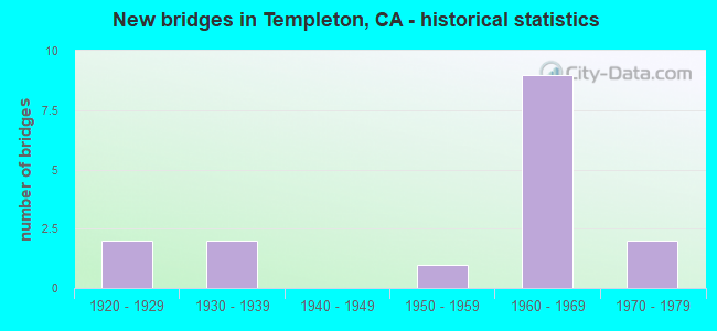
- New bridges - historical statistics
- 21920-1929
- 21930-1939
- 11950-1959
- 91960-1969
- 21970-1979

- Reconstructed bridges - Historical Statistics
- 21960-1969
- 01970-1979
- 11980-1989
- 01990-1999
- 02000-2009
- 32010-2019


- Bridge Condition - Deck
- 55.6%Good
- 33.3%Satisfactory
- 11.1%Fair

- Bridge Condition - Superstructure
- 88.9%Good
- 11.1%Poor

- Bridge Condition - Substructure
- 88.9%Good
- 11.1%Poor

- Bridge Condition - Channel
- 25.0%Very good
- 50.0%Good
- 12.5%Satisfactory
- 12.5%Fair
Find on map >> Show street view
Structure Number: 49 0002R, Location: 05-SLO-101-49.64 (Lat: 35.530136, Lng: -120.707739), Route carried "on" structure: US 101, Year Built: 1939, Year Reconstructed: 1994, Status: Open, Structure Length: 5.18m (16.99ft), Average Daily Traffic: 31,000 (year 2009), Truck Traffic: 3%, Average Future Daily Traffic: 38,685 (year 2043), Design Load: H 15, Features Intersected: PASO ROBLES CREEK
Minimum Vertical Clearance: 30+ m (98+ ft), Kilometerpoint: 49.640, Lanes on structure: 2, Base Highway Network: Yes (Inventory Route: 1, Subroute: 1), Owner: State Highway Agency, Approaching Roadway Width: 11.9m (39.0ft), Skew: 2 degrees, Material/Design: Concrete continuous, Design/Construction: Tee Beam, Number Of Spans In Main Unit: 4, Length of Maximum Span: 14.6m (47.9ft), Curb-To-Curb Width: 12.0m (39.4ft), Out-to-Out Width: 13.0m (42.7ft)
Condition: Deck: Good, Superstructure: Good, Substructure: Good, Channel: Satisfactory, Operating Rating: 39.2 metric tons, Method Used To Determine Operating Rating: Load Factor (LF), Inventory Rating: 23.7 metric tons, Method Used To Determine Inventory Rating: Load Factor (LF), Structural Evaluation: Somewhat better than minimum adequacy, Deck Geometry: Better than present minimum criteria, Waterway Adequacy: Superior to present desirable criteria, Approach Roadway Alignment: Equal to present desirable criteria, Designated Inspection Frequency: Every 24 months, Inspection Date: May 2021, Deck Structure Type: Concrete Cast-file-Place, Wearing Surface/Protective System: Wearing Surface: Bituminous
Find on map >> Show street view
Structure Number: 49 0105, Location: 05-SLO-046-R15.85 (Lat: 35.548344, Lng: -120.787575), Route carried "on" structure: State highway 46, Year Built: 1969, Status: Open, Structure Length: 4.88m (16.01ft), Average Daily Traffic: 4,600 (year 2009), Average Future Daily Traffic: 5,628 (year 2037), Design Load: HS 20, Features Intersected: JACK CREEK (PSO RBLS CR)
Minimum Vertical Clearance: 30+ m (98+ ft), Kilometerpoint: 15.850, Lanes on structure: 2, Base Highway Network: Yes (, Subroute: 1), Owner: State Highway Agency, Approaching Roadway Width: 12.2m (40.0ft), Skew: 4 degrees, Material/Design: Concrete continuous, Design/Construction: Tee Beam, Number Of Spans In Main Unit: 3, Length of Maximum Span: 18.9m (62.0ft), Curb-To-Curb Width: 12.2m (40.0ft), Out-to-Out Width: 12.8m (42.0ft)
Condition: Deck: Good, Superstructure: Good, Substructure: Good, Channel: Very good, Operating Rating: 31.4 metric tons, Method Used To Determine Operating Rating: Load and Resistance Factor Rating (LRFR) rating reported by rating factor(RF) method using HL-93 loadings, Inventory Rating: 20.1 metric tons, Method Used To Determine Inventory Rating: Load and Resistance Factor Rating (LRFR) rating reported by rating factor(RF) method using HL-93 loadings, Structural Evaluation: Somewhat better than minimum adequacy, Deck Geometry: Equal to present minimum criteria, Waterway Adequacy: Superior to present desirable criteria, Approach Roadway Alignment: Equal to present desirable criteria, Designated Inspection Frequency: Every 24 months, Inspection Date: September 2020, Deck Structure Type: Concrete Cast-file-Place, Wearing Surface/Protective System: Wearing Surface: Bituminous
Find on map >> Show street view
Structure Number: 49 0137, Location: 05-SLO-101-53.17 (Lat: 35.575756, Lng: -120.697353), Route carried "on" structure: US 101, Year Built: 1952, Year Reconstructed: 1974, Status: Open, Structure Length: 0.67m (2.20ft), Average Daily Traffic: 54,000 (year 2009), Truck Traffic: 9%, Average Future Daily Traffic: 71,674 (year 2039), Features Intersected: WHITEHORSE DRAW
Minimum Vertical Clearance: 30+ m (98+ ft), Kilometerpoint: 53.170, Lanes on structure: 4, Base Highway Network: Yes (Inventory Route: 1, Subroute: 1), Owner: State Highway Agency, Approaching Roadway Width: 34.1m (111.9ft), Material/Design: Concrete continuous, Design/Construction: Culvert, Number Of Spans In Main Unit: 2, Length of Maximum Span: 3.0m (9.8ft)
Condition: Channel: Very good, Culverts: Good, Operating Rating: 54.1 metric tons, Method Used To Determine Operating Rating: Field evaluation and documented engineering judgment, Inventory Rating: 32.4 metric tons, Method Used To Determine Inventory Rating: Field evaluation and documented engineering judgment, Structural Evaluation: Better than present minimum criteria, Waterway Adequacy: Superior to present desirable criteria, Approach Roadway Alignment: Equal to present desirable criteria, Designated Inspection Frequency: Every 24 months, Inspection Date: September 2021
Find on map >> Show street view
Structure Number: 49 0194L, Location: 05-SLO-101-51.45 (Lat: 35.554253, Lng: -120.712258), Route carried "on" structure: US 101, Year Built: 1967, Status: Open, Structure Length: 3.69m (12.11ft), Average Daily Traffic: 31,000 (year 2009), Truck Traffic: 3%, Average Future Daily Traffic: 37,418 (year 2039), Design Load: HS 20+Mod, Features Intersected: LAS TABLAS AVE
Minimum Vertical Clearance: 30+ m (98+ ft), Kilometerpoint: 51.450, Lanes on structure: 2, Lanes under structure: 3, Base Highway Network: Yes (Inventory Route: 1, Subroute: 1), Owner: State Highway Agency, Approaching Roadway Width: 10.1m (33.1ft), Skew: 3 degrees, Material/Design: Concrete continuous, Design/Construction: Tee Beam, Number Of Spans In Main Unit: 3, Length of Maximum Span: 16.6m (54.5ft), Curb-To-Curb Width: 11.5m (37.7ft), Out-to-Out Width: 12.1m (39.7ft)
Condition: Deck: Good, Superstructure: Good, Substructure: Good, Operating Rating: 43.4 metric tons, Method Used To Determine Operating Rating: Load and Resistance Factor Rating (LRFR) rating reported by rating factor(RF) method using HL-93 loadings, Inventory Rating: 33.4 metric tons, Method Used To Determine Inventory Rating: Load and Resistance Factor Rating (LRFR) rating reported by rating factor(RF) method using HL-93 loadings, Structural Evaluation: Better than present minimum criteria, Deck Geometry: Equal to present minimum criteria, Underclear: High priority of corrective action, Approach Roadway Alignment: Equal to present desirable criteria, Designated Inspection Frequency: Every 24 months, Inspection Date: September 2021, Deck Structure Type: Concrete Cast-file-Place, Wearing Surface/Protective System: Wearing Surface: Integral Concrete
Find on map >> Show street view
Structure Number: 49 0194R, Location: 05-SLO-101-51.45 (Lat: 35.554253, Lng: -120.711942), Route carried "on" structure: US 101, Year Built: 1967, Status: Open, Structure Length: 3.69m (12.11ft), Average Daily Traffic: 31,000 (year 2009), Truck Traffic: 3%, Average Future Daily Traffic: 37,418 (year 2039), Design Load: HS 20+Mod, Features Intersected: LAS TABLAS AVE
Minimum Vertical Clearance: 30+ m (98+ ft), Kilometerpoint: 51.450, Lanes on structure: 2, Lanes under structure: 3, Base Highway Network: Yes (Inventory Route: 1, Subroute: 1), Owner: State Highway Agency, Approaching Roadway Width: 10.1m (33.1ft), Skew: 3 degrees, Material/Design: Concrete continuous, Design/Construction: Tee Beam, Number Of Spans In Main Unit: 3, Length of Maximum Span: 16.6m (54.5ft), Curb-To-Curb Width: 11.5m (37.7ft), Out-to-Out Width: 12.1m (39.7ft)
Condition: Deck: Good, Superstructure: Good, Substructure: Good, Operating Rating: 43.4 metric tons, Method Used To Determine Operating Rating: Load and Resistance Factor Rating (LRFR) rating reported by rating factor(RF) method using HL-93 loadings, Inventory Rating: 33.4 metric tons, Method Used To Determine Inventory Rating: Load and Resistance Factor Rating (LRFR) rating reported by rating factor(RF) method using HL-93 loadings, Structural Evaluation: Better than present minimum criteria, Deck Geometry: Equal to present minimum criteria, Underclear: High priority of corrective action, Approach Roadway Alignment: Equal to present desirable criteria, Designated Inspection Frequency: Every 24 months, Inspection Date: September 2021, Deck Structure Type: Concrete Cast-file-Place, Wearing Surface/Protective System: Wearing Surface: Integral Concrete
Find on map >> Show street view
Structure Number: 49 0195, Location: 05-SLO-101-50.64 (Lat: 35.543600, Lng: -120.714875), Route carried "on" structure: County highway W113, Year Built: 1967, Year Reconstructed: 2010, Status: Open, Structure Length: 5.91m (19.39ft), Average Daily Traffic: 6,600 (year 2005), Truck Traffic: 5%, Average Future Daily Traffic: 11,046 (year 2041), Design Load: HS 20, Features Intersected: US HIGHWAY 101, Facility Carried by Structure: VINEYARD DR
Minimum Vertical Clearance: 30+ m (98+ ft), Kilometerpoint: 0.000, Lanes on structure: 3, Lanes under structure: 5, Base Highway Network: Yes, Owner: State Highway Agency, Approaching Roadway Width: 14.1m (46.3ft), Material/Design: Concrete continuous, Design/Construction: Box Beam or Girders - Multiple, Number Of Spans In Main Unit: 2, Length of Maximum Span: 33.9m (111.2ft), Curb or Sidewalk Widths: Left: 2.1m (6.9ft), Right: 0.0m, Curb-To-Curb Width: 14.1m (46.3ft), Out-to-Out Width: 16.9m (55.4ft)
Condition: Deck: Good, Superstructure: Good, Substructure: Good, Operating Rating: 41.8 metric tons, Method Used To Determine Operating Rating: Load and Resistance Factor Rating (LRFR) rating reported by rating factor(RF) method using HL-93 loadings, Inventory Rating: 32.1 metric tons, Method Used To Determine Inventory Rating: Load and Resistance Factor Rating (LRFR) rating reported by rating factor(RF) method using HL-93 loadings, Structural Evaluation: Better than present minimum criteria, Deck Geometry: Somewhat better than minimum adequacy, Underclear: Meets minimum limits, Approach Roadway Alignment: Equal to present desirable criteria, Designated Inspection Frequency: Every 24 months, Inspection Date: September 2021, Deck Structure Type: Concrete Cast-file-Place, Wearing Surface/Protective System: Wearing Surface: Integral Concrete
Find on map >> Show street view
Structure Number: 49 02, Location: 05-SLO-101-52.44 (Lat: 35.565994, Lng: -120.702267), Route carried "on" structure: County highway W113, Year Built: 1966, Status: Open, Structure Length: 5.90m (19.36ft), Average Daily Traffic: 6,800 (year 2008), Truck Traffic: 5%, Average Future Daily Traffic: 9,116 (year 2041), Design Load: HS 20+Mod, Features Intersected: US HIGHWAY 101, Facility Carried by Structure: MAIN STREET
Minimum Vertical Clearance: 30+ m (98+ ft), Kilometerpoint: 0.000, Lanes on structure: 2, Lanes under structure: 4, Base Highway Network: Yes, Owner: State Highway Agency, Approaching Roadway Width: 10.1m (33.1ft), Skew: 2 degrees, Material/Design: Prestressed concrete, Design/Construction: Stringer/Multi-beam, Number Of Spans In Main Unit: 2, Number Of Approach Spans: 2, Length of Maximum Span: 19.1m (62.7ft), Curb or Sidewalk Widths: Left: 0.0m, Right: 1.5m (4.9ft), Curb-To-Curb Width: 9.2m (30.2ft), Out-to-Out Width: 11.4m (37.4ft)
Condition: Deck: Fair, Superstructure: Good, Substructure: Good, Operating Rating: 36.9 metric tons, Method Used To Determine Operating Rating: Load and Resistance Factor Rating (LRFR) rating reported by rating factor(RF) method using HL-93 loadings, Inventory Rating: 26.2 metric tons, Method Used To Determine Inventory Rating: Load and Resistance Factor Rating (LRFR) rating reported by rating factor(RF) method using HL-93 loadings, Structural Evaluation: Equal to present minimum criteria, Deck Geometry: High priority of corrective action, Underclear: Equal to present minimum criteria, Approach Roadway Alignment: Equal to present desirable criteria, Designated Inspection Frequency: Every 24 months, Inspection Date: September 2021, Deck Structure Type: Concrete Cast-file-Place, Wearing Surface/Protective System: Wearing Surface: Integral Concrete
Find on map >> Show street view
Structure Number: 49C0177, Location: 0.3 MI E OF U.S. 101 (Lat: 35.543142, Lng: -120.706353), Route carried "on" structure: County highway , Year Built: 1977, Status: Open, Structure Length: 20.51m (67.29ft), Average Daily Traffic: 4,119 (year 2010), Truck Traffic: 3%, Average Future Daily Traffic: 4,211 (year 2040), Design Load: HS 20, Features Intersected: SALINAS RIVER, Facility Carried by Structure: VINEYARD DR
Minimum Vertical Clearance: 30+ m (98+ ft), Kilometerpoint: 0.000, Lanes on structure: 2, Base Highway Network: Yes, Owner: County Highway Agency, Approaching Roadway Width: 9.8m (32.2ft), Skew: 1 degrees, Material/Design: Concrete continuous, Design/Construction: Box Beam or Girders - Multiple, Number Of Spans In Main Unit: 5, Number Of Approach Spans: 2, Length of Maximum Span: 38.1m (125.0ft), Curb-To-Curb Width: 9.8m (32.2ft), Out-to-Out Width: 10.0m (32.8ft)
Condition: Deck: Satisfactory, Superstructure: Good, Substructure: Good, Channel: Good, Operating Rating: 99.8 metric tons, Method Used To Determine Operating Rating: Load Factor (LF), Inventory Rating: 65.4 metric tons, Method Used To Determine Inventory Rating: Load Factor (LF), Structural Evaluation: Better than present minimum criteria, Deck Geometry: Meets minimum limits, Underclear: Better than present minimum criteria, Waterway Adequacy: Superior to present desirable criteria, Approach Roadway Alignment: Better than present minimum criteria, Designated Inspection Frequency: Every 24 months, Inspection Date: July 2020, Deck Structure Type: Concrete Cast-file-Place
Find on map >> Show street view
Structure Number: 49C0342, Location: 0.2 MI N STATE RTE 46 (Lat: 35.548272, Lng: -120.793064), Route carried "on" structure: County highway , Year Built: 1938, Year Reconstructed: 1969, Status: Posted for load-capacity, Structure Length: 6.22m (20.41ft), Average Daily Traffic: 151 (year 2007), Truck Traffic: 5%, Average Future Daily Traffic: 151 (year 2040), Design Load: H 15, Features Intersected: PASO ROBLES CREEK, Facility Carried by Structure: JACK CREEK RD
Minimum Vertical Clearance: 30+ m (98+ ft), Kilometerpoint: 0.000, Lanes on structure: 1, Owner: County Highway Agency, Approaching Roadway Width: 7.4m (24.3ft), Material/Design: Wood or Timber, Design/Construction: Stringer/Multi-beam, Number Of Spans In Main Unit: 11, Length of Maximum Span: 5.8m (19.0ft), Curb or Sidewalk Widths: Left: 0.2m (0.7ft), Right: 0.2m (0.7ft), Curb-To-Curb Width: 4.0m (13.1ft), Out-to-Out Width: 7.9m (25.9ft)
Condition: Deck: Satisfactory, Superstructure: Poor, Substructure: Poor, Channel: Good, Operating Rating: 20.4 metric tons, Method Used To Determine Operating Rating: Allowable Stress (AS), Inventory Rating: 13.3 metric tons, Method Used To Determine Inventory Rating: Allowable Stress (AS), Structural Evaluation: Meets minimum limits, Deck Geometry: High priority of replacement, Waterway Adequacy: Better than present minimum criteria, Approach Roadway Alignment: Equal to present desirable criteria, Length Of Structure Improvement: 6.22m (20.41ft), Designated Inspection Frequency: Every 24 months, Inspection Date: July 2020, Bridge Improvement Cost: $1,131,000, Roadway Improvement Cost: $226,000, Total Project Cost: $1,901,000 ( Estimate for 2019), Deck Structure Type: Concrete Cast-file-Place
Find on map >> Show street view
Structure Number: 49C0348, Location: 0.9 MI SWVINEYARD DR (Lat: 35.536883, Lng: -120.727553), Route carried "on" structure: County highway , Year Built: 1971, Status: Open, Structure Length: 4.54m (14.90ft), Average Daily Traffic: 538 (year 2010), Truck Traffic: 1%, Average Future Daily Traffic: 596 (year 2040), Design Load: H 15, Features Intersected: PASO ROBLES CREEK, Facility Carried by Structure: SNTA RITA OLD CK R
Minimum Vertical Clearance: 30+ m (98+ ft), Kilometerpoint: 0.000, Lanes on structure: 2, Owner: County Highway Agency, Approaching Roadway Width: 8.5m (27.9ft), Skew: 9 degrees, Material/Design: Concrete continuous, Design/Construction: Tee Beam, Number Of Spans In Main Unit: 3, Length of Maximum Span: 16.5m (54.1ft), Curb-To-Curb Width: 8.5m (27.9ft), Out-to-Out Width: 8.7m (28.5ft)
Condition: Deck: Satisfactory, Superstructure: Good, Substructure: Good, Channel: Fair, Operating Rating: 62.5 metric tons, Method Used To Determine Operating Rating: Load and Resistance Factor Rating (LRFR) rating reported by rating factor(RF) method using HL-93 loadings, Inventory Rating: 48.3 metric tons, Method Used To Determine Inventory Rating: Load and Resistance Factor Rating (LRFR) rating reported by rating factor(RF) method using HL-93 loadings, Structural Evaluation: Better than present minimum criteria, Deck Geometry: Somewhat better than minimum adequacy, Waterway Adequacy: Superior to present desirable criteria, Approach Roadway Alignment: Somewhat better than minimum adequacy, Designated Inspection Frequency: Every 24 months, Inspection Date: July 2020, Deck Structure Type: Concrete Cast-file-Place
Find on map >> Show street view
Structure Number: 49C0402, Location: 0.35 MI SOUTH RAMADA DR (Lat: 35.561233, Lng: -120.700594), Route carried "on" structure: County highway , Year Built: 1929, Year Reconstructed: 2016, Status: Open, Structure Length: 0.81m (2.66ft), Average Daily Traffic: 6,836 (year 2009), Truck Traffic: 3%, Average Future Daily Traffic: 9,243 (year 2040), Features Intersected: TEMPLETON CREEK, Facility Carried by Structure: MAIN ST
Minimum Vertical Clearance: 30+ m (98+ ft), Kilometerpoint: 0.000, Lanes on structure: 2, Owner: County Highway Agency, Approaching Roadway Width: 13.9m (45.6ft), Material/Design: Concrete continuous, Design/Construction: Culvert, Number Of Spans In Main Unit: 3, Length of Maximum Span: 2.7m (8.9ft)
Condition: Channel: Good, Culverts: Good, Operating Rating: 27.2 metric tons, Method Used To Determine Operating Rating: Field evaluation and documented engineering judgment, Inventory Rating: 16.2 metric tons, Method Used To Determine Inventory Rating: Field evaluation and documented engineering judgment, Structural Evaluation: Meets minimum limits, Waterway Adequacy: Superior to present desirable criteria, Approach Roadway Alignment: Equal to present desirable criteria, Designated Inspection Frequency: Every 24 months, Inspection Date: July 2020
Find on map >> Show street view
Structure Number: 49C0403, Location: 0.3 MI SOUTH RAMADA DR (Lat: 35.562014, Lng: -120.700475), Route carried "on" structure: County highway , Year Built: 1929, Year Reconstructed: 2016, Status: Open, Structure Length: 0.68m (2.23ft), Average Daily Traffic: 6,836 (year 2009), Truck Traffic: 3%, Average Future Daily Traffic: 9,243 (year 2039), Features Intersected: NORTH FORK TEMPLETON CRK, Facility Carried by Structure: MAIN ST
Minimum Vertical Clearance: 30+ m (98+ ft), Kilometerpoint: 0.000, Lanes on structure: 2, Owner: County Highway Agency, Approaching Roadway Width: 7.9m (25.9ft), Material/Design: Concrete continuous, Design/Construction: Culvert, Number Of Spans In Main Unit: 2, Length of Maximum Span: 3.4m (11.2ft)
Condition: Channel: Good, Culverts: Good, Operating Rating: 27.2 metric tons, Method Used To Determine Operating Rating: Field evaluation and documented engineering judgment, Inventory Rating: 16.2 metric tons, Method Used To Determine Inventory Rating: Field evaluation and documented engineering judgment, Structural Evaluation: Meets minimum limits, Waterway Adequacy: Superior to present desirable criteria, Approach Roadway Alignment: Equal to present desirable criteria, Designated Inspection Frequency: Every 24 months, Inspection Date: July 2020
Find on map >> Show street view
Structure Number: 49 0194L, Location: 05-SLO-101-51.45 (Lat: 35.554253, Lng: -120.712258), Route carried "under" structure: Business City street , Year Built: 1967, Structure Length: 0. m, Average Daily Traffic: 2,000 (year 2005), Truck Traffic: 7%, Features Intersected: LAS TABLAS AVE, Facility Carried by Structure: US HIGHWAY 101 SB
Minimum Vertical Clearance: 4.97m (16.31ft), Kilometerpoint: 0.000, Lanes on structure: 2, Lanes under structure: 3, Material/Design: Concrete continuous, Design/Construction: Tee Beam, Length of Maximum Span: 16.6m (54.5ft)
Find on map >> Show street view
Structure Number: 49 0194R, Location: 05-SLO-101-51.45 (Lat: 35.554253, Lng: -120.711942), Route carried "under" structure: Business City street , Year Built: 1967, Structure Length: 0. m, Average Daily Traffic: 2,000 (year 2005), Truck Traffic: 7%, Features Intersected: LAS TABLAS AVE, Facility Carried by Structure: US HIGHWAY 101 NB
Minimum Vertical Clearance: 4.97m (16.31ft), Kilometerpoint: 0.000, Lanes on structure: 2, Lanes under structure: 3, Material/Design: Concrete continuous, Design/Construction: Tee Beam, Length of Maximum Span: 16.6m (54.5ft)
Find on map >> Show street view
Structure Number: 49 0195, Location: 05-SLO-101-50.64 (Lat: 35.543600, Lng: -120.714875), Route carried "under" structure: US 101, Year Built: 1967, Structure Length: 0. m, Average Daily Traffic: 62,000 (year 2009), Truck Traffic: 3%, Features Intersected: US HIGHWAY 101, Facility Carried by Structure: VINEYARD DR
Minimum Vertical Clearance: 4.74m (15.55ft), Kilometerpoint: 50.640, Lanes on structure: 3, Lanes under structure: 5, Material/Design: Concrete continuous, Design/Construction: Box Beam or Girders - Multiple, Length of Maximum Span: 33.9m (111.2ft)
Find on map >> Show street view
Structure Number: 49 02, Location: 05-SLO-101-52.44 (Lat: 35.565994, Lng: -120.702267), Route carried "under" structure: US 101, Year Built: 1966, Structure Length: 0. m, Average Daily Traffic: 62,000 (year 2009), Truck Traffic: 3%, Features Intersected: US HIGHWAY 101, Facility Carried by Structure: MAIN STREET
Minimum Vertical Clearance: 4.92m (16.14ft), Kilometerpoint: 52.440, Lanes on structure: 2, Lanes under structure: 4, Material/Design: Prestressed concrete, Design/Construction: Stringer/Multi-beam, Length of Maximum Span: 19.1m (62.7ft)