Bridge Statistics for Teays Valley, West Virginia (WV)
Condition, Traffic, Stress, Structural Evaluation, Project Costs
- National Bridge Inventory (NBI) Statistics
- 16Number of bridges
- 89ft / 26.5mTotal length
- $8,440,000Total costs
- 247,099Total average daily traffic
- 44,767Total average daily truck traffic
- National Bridge Inventory (NBI) Registered Bridges for Teays Valley
- No street view available for this location
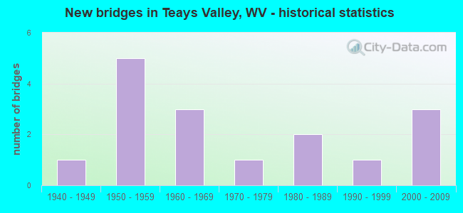
- New bridges - historical statistics
- 11940-1949
- 51950-1959
- 31960-1969
- 11970-1979
- 21980-1989
- 11990-1999
- 32000-2009

- Reconstructed bridges - Historical Statistics
- 31980-1989
- 11990-1999


- Bridge Condition - Deck
- 11.1%Very good
- 33.3%Good
- 22.2%Satisfactory
- 11.1%Fair
- 22.2%Poor

- Bridge Condition - Superstructure
- 11.1%Very good
- 55.6%Good
- 11.1%Satisfactory
- 22.2%Fair

- Bridge Condition - Substructure
- 11.1%Very good
- 33.3%Good
- 44.4%Fair
- 11.1%Poor

- Bridge Condition - Channel
- 20.0%Very good
- 30.0%Good
- 40.0%Satisfactory
- 10.0%Fair

- Bridge Condition - Culverts
- 33.3%Good
- 33.3%Satisfactory
- 33.3%Fair
Find on map >> Show street view
Structure Number: 40A027, Location: 0.65 MI E OF CR 46 SLS (Lat: 38.450561, Lng: -81.931711), Route carried "on" structure: County highway 33, Year Built: 1988, Status: Open, Structure Length: 0.95m (3.12ft), Average Daily Traffic: 6,100 (year 2018), Truck Traffic: 4%, Average Future Daily Traffic: 8,235 (year 2038), Design Load: HS 20, Features Intersected: POPLAR FK OF MILL CR
Minimum Vertical Clearance: 30+ m (98+ ft), Kilometerpoint: 1.336, Lanes on structure: 2, Owner: State Highway Agency, Approaching Roadway Width: 10.4m (34.1ft), Material/Design: Prestressed concrete, Design/Construction: Box Beam or Girders - Multiple, Number Of Spans In Main Unit: 1, Length of Maximum Span: 7.9m (25.9ft), Curb-To-Curb Width: 10.0m (32.8ft), Out-to-Out Width: 11.1m (36.4ft)
Condition: Deck: Good, Superstructure: Good, Substructure: Good, Channel: Good, Operating Rating: 88.9 metric tons, Method Used To Determine Operating Rating: Load Factor (LF), Inventory Rating: 82.5 metric tons, Method Used To Determine Inventory Rating: Load Factor (LF), Structural Evaluation: Better than present minimum criteria, Deck Geometry: Meets minimum limits, Waterway Adequacy: Superior to present desirable criteria, Approach Roadway Alignment: Equal to present desirable criteria, Designated Inspection Frequency: Every 24 months, Inspection Date: January 2020, Deck Structure Type: Other, Wearing Surface/Protective System: Wearing Surface: Bituminous, Deck Protection: Epoxy Coated Reinforcing
Find on map >> Show street view
Structure Number: 40A07, Location: 2.83 MI EAST OF WV 34 (Lat: 38.455819, Lng: -81.883400), Route carried "on" structure: Interstate 64, Year Built: 1959, Year Reconstructed: 1988, Status: Open, Structure Length: 8.85m (29.04ft), Average Daily Traffic: 32,200 (year 2018), Truck Traffic: 17%, Average Future Daily Traffic: 43,470 (year 2038), Design Load: HS 20, Features Intersected: CR 29 & ROCKY STEP RUN
Minimum Vertical Clearance: 30+ m (98+ ft), Kilometerpoint: 66.804, Lanes on structure: 2, Lanes under structure: 2, Base Highway Network: Yes, Owner: State Highway Agency, Approaching Roadway Width: 11.3m (37.1ft), Material/Design: Steel continuous, Design/Construction: Stringer/Multi-beam, Number Of Spans In Main Unit: 2, Number Of Approach Spans: 3, Length of Maximum Span: 21.0m (68.9ft), Curb-To-Curb Width: 12.0m (39.4ft), Out-to-Out Width: 13.1m (43.0ft)
Condition: Deck: Satisfactory, Superstructure: Satisfactory, Substructure: Fair, Channel: Very good, Operating Rating: 80.7 metric tons, Method Used To Determine Operating Rating: Load Factor (LF), Inventory Rating: 48.1 metric tons, Method Used To Determine Inventory Rating: Load Factor (LF), Structural Evaluation: Somewhat better than minimum adequacy, Deck Geometry: Equal to present minimum criteria, Underclear: Somewhat better than minimum adequacy, Waterway Adequacy: Superior to present desirable criteria, Approach Roadway Alignment: Equal to present desirable criteria, Length Of Structure Improvement: 8.84m (29.00ft), Designated Inspection Frequency: Every 24 months, Inspection Date: Febuary 2020, Bridge Improvement Cost: $4,500,000, Roadway Improvement Cost: $500,000, Total Project Cost: $5,000,000 ( Estimate for 2020), Deck Structure Type: Concrete Cast-file-Place, Wearing Surface/Protective System: Wearing Surface: Monolithic Concrete, Deck Protection: Epoxy Coated Reinforcing
Find on map >> Show street view
Structure Number: 40A071, Location: 3.18 MI EAST OF WV 34 F (Lat: 38.455239, Lng: -81.877231), Route carried "on" structure: Interstate 64, Year Built: 1959, Year Reconstructed: 1988, Status: Open, Structure Length: 4.03m (13.22ft), Average Daily Traffic: 64,400 (year 2018), Truck Traffic: 17%, Average Future Daily Traffic: 86,940 (year 2040), Design Load: HS 20, Features Intersected: CR 33/5
Minimum Vertical Clearance: 30+ m (98+ ft), Kilometerpoint: 67.367, Lanes on structure: 2, Lanes under structure: 2, Base Highway Network: Yes, Owner: State Highway Agency, Approaching Roadway Width: 11.3m (37.1ft), Skew: 1 degrees, Material/Design: Steel continuous, Design/Construction: Stringer/Multi-beam, Number Of Spans In Main Unit: 1, Number Of Approach Spans: 2, Length of Maximum Span: 15.2m (49.9ft), Curb-To-Curb Width: 11.7m (38.4ft), Out-to-Out Width: 12.8m (42.0ft)
Condition: Deck: Fair, Superstructure: Good, Substructure: Poor, Operating Rating: 88.9 metric tons, Method Used To Determine Operating Rating: Load Factor (LF), Inventory Rating: 64.4 metric tons, Method Used To Determine Inventory Rating: Load Factor (LF), Structural Evaluation: Meets minimum limits, Deck Geometry: Equal to present minimum criteria, Underclear: Superior to present desirable criteria, Approach Roadway Alignment: Equal to present desirable criteria, Length Of Structure Improvement: 4.03m (13.22ft), Designated Inspection Frequency: Every 24 months, Inspection Date: January 2022, Bridge Improvement Cost: $800,000, Roadway Improvement Cost: $200,000, Total Project Cost: $1,000,000 ( Estimate for 2019), Deck Structure Type: Concrete Cast-file-Place, Wearing Surface/Protective System: Wearing Surface: Monolithic Concrete, Deck Protection: Epoxy Coated Reinforcing
Find on map >> Show street view
Structure Number: 40A096, Location: 0.03 MI N OF CR 46/1 (Lat: 38.427061, Lng: -81.882950), Route carried "on" structure: County highway 4400, Year Built: 1986, Status: Open, Structure Length: 0.71m (2.33ft), Average Daily Traffic: 450 (year 2018), Truck Traffic: 3%, Average Future Daily Traffic: 608 (year 2038), Design Load: HS 20, Features Intersected: SCARY CREEK, Facility Carried by Structure: CR 44
Minimum Vertical Clearance: 30+ m (98+ ft), Kilometerpoint: 2.607, Lanes on structure: 1, Owner: State Highway Agency, Approaching Roadway Width: 3.7m (12.1ft), Skew: 3 degrees, Material/Design: Prestressed concrete, Design/Construction: Slab, Number Of Spans In Main Unit: 1, Length of Maximum Span: 6.1m (20.0ft), Curb-To-Curb Width: 4.7m (15.4ft), Out-to-Out Width: 4.9m (16.1ft)
Condition: Deck: Good, Superstructure: Good, Substructure: Fair, Channel: Satisfactory, Operating Rating: 67.1 metric tons, Method Used To Determine Operating Rating: Load Factor (LF), Inventory Rating: 39.9 metric tons, Method Used To Determine Inventory Rating: Load Factor (LF), Structural Evaluation: Somewhat better than minimum adequacy, Deck Geometry: High priority of replacement, Waterway Adequacy: Equal to present minimum criteria, Approach Roadway Alignment: Equal to present minimum criteria, Length Of Structure Improvement: 0.71m (2.33ft), Designated Inspection Frequency: Every 24 months, Inspection Date: January 2021, Bridge Improvement Cost: $75,000, Roadway Improvement Cost: $25,000, Total Project Cost: $100,000 ( Estimate for 2021), Deck Structure Type: Other, Wearing Surface/Protective System: Wearing Surface: Bituminous
Find on map >> Show street view
Structure Number: 40A098, Location: 0.07 MI N OF CR 33 (Lat: 38.453161, Lng: -81.860781), Route carried "on" structure: County highway 44, Year Built: 1960, Status: Open, Structure Length: 6.32m (20.73ft), Average Daily Traffic: 750 (year 2020), Truck Traffic: 4%, Average Future Daily Traffic: 1,005 (year 2040), Design Load: HS 20, Features Intersected: I-64 EB & WB
Minimum Vertical Clearance: 30+ m (98+ ft), Kilometerpoint: 8.964, Lanes on structure: 2, Lanes under structure: 4, Owner: State Highway Agency, Approaching Roadway Width: 7.3m (24.0ft), Skew: 2 degrees, Material/Design: Steel continuous, Design/Construction: Stringer/Multi-beam, Number Of Spans In Main Unit: 2, Number Of Approach Spans: 2, Length of Maximum Span: 16.9m (55.4ft), Curb or Sidewalk Widths: Left: 0.7m (2.3ft), Right: 0.7m (2.3ft), Curb-To-Curb Width: 8.5m (27.9ft), Out-to-Out Width: 10.8m (35.4ft)
Condition: Deck: Poor, Superstructure: Fair, Substructure: Fair, Operating Rating: 68.9 metric tons, Method Used To Determine Operating Rating: Load Factor (LF), Inventory Rating: 40.8 metric tons, Method Used To Determine Inventory Rating: Load Factor (LF), Structural Evaluation: Somewhat better than minimum adequacy, Deck Geometry: Somewhat better than minimum adequacy, Underclear: Somewhat better than minimum adequacy, Approach Roadway Alignment: Equal to present desirable criteria, Length Of Structure Improvement: 7.01m (23.00ft), Designated Inspection Frequency: Every 24 months, Inspection Date: September 2021, Bridge Improvement Cost: $1,750,000, Roadway Improvement Cost: $125,000, Total Project Cost: $1,965,000 ( Estimate for 2019), Deck Structure Type: Concrete Cast-file-Place, Wearing Surface/Protective System: Wearing Surface: Integral Concrete
Find on map >> Show street view
Structure Number: 40A099, Location: 0.53 MI N OF CR 42 (Lat: 38.467811, Lng: -81.864800), Route carried "on" structure: County highway 4400, Year Built: 1971, Status: Open, Structure Length: 0.85m (2.79ft), Average Daily Traffic: 500 (year 2018), Truck Traffic: 3%, Average Future Daily Traffic: 675 (year 2038), Design Load: H 20, Features Intersected: BILLS CREEK, Facility Carried by Structure: CR 44
Minimum Vertical Clearance: 30+ m (98+ ft), Kilometerpoint: 12.038, Lanes on structure: 2, Owner: State Highway Agency, Approaching Roadway Width: 5.2m (17.1ft), Skew: 3 degrees, Material/Design: Steel, Design/Construction: Stringer/Multi-beam, Number Of Spans In Main Unit: 1, Length of Maximum Span: 7.4m (24.3ft), Curb or Sidewalk Widths: Left: 0.2m (0.7ft), Right: 0.2m (0.7ft), Curb-To-Curb Width: 5.8m (19.0ft), Out-to-Out Width: 6.1m (20.0ft)
Condition: Deck: Poor, Superstructure: Fair, Substructure: Fair, Channel: Fair, Operating Rating: 88.9 metric tons, Method Used To Determine Operating Rating: Load Factor (LF), Inventory Rating: 54.4 metric tons, Method Used To Determine Inventory Rating: Load Factor (LF), Structural Evaluation: Somewhat better than minimum adequacy, Deck Geometry: High priority of replacement, Waterway Adequacy: Equal to present minimum criteria, Approach Roadway Alignment: Equal to present minimum criteria, Length Of Structure Improvement: 0.85m (2.79ft), Designated Inspection Frequency: Every 24 months, Inspection Date: January 2021, Bridge Improvement Cost: $200,000, Roadway Improvement Cost: $50,000, Total Project Cost: $250,000 ( Estimate for 2021), Deck Structure Type: Wood or Timber, Wearing Surface/Protective System: Wearing Surface: Bituminous
Find on map >> Show street view
Structure Number: 40A113, Location: 0.03 MI N OF CR 32 (Lat: 38.458919, Lng: -81.934000), Route carried "on" structure: State highway 34, Year Built: 1960, Year Reconstructed: 1988, Status: Open, Structure Length: 0.64m (2.10ft), Average Daily Traffic: 17,400 (year 2019), Truck Traffic: 6%, Average Future Daily Traffic: 23,490 (year 2039), Features Intersected: POPLAR FORK
Minimum Vertical Clearance: 30+ m (98+ ft), Kilometerpoint: 24.591, Lanes on structure: 5, Owner: State Highway Agency, Approaching Roadway Width: 22.3m (73.2ft), Material/Design: Concrete continuous, Design/Construction: Culvert, Number Of Spans In Main Unit: 2, Length of Maximum Span: 3.0m (9.8ft)
Condition: Channel: Good, Culverts: Fair, Operating Rating: 63.5 metric tons, Method Used To Determine Operating Rating: Field evaluation and documented engineering judgment, Inventory Rating: 29.0 metric tons, Method Used To Determine Inventory Rating: Field evaluation and documented engineering judgment, Structural Evaluation: Somewhat better than minimum adequacy, Waterway Adequacy: Superior to present desirable criteria, Approach Roadway Alignment: Equal to present desirable criteria, Designated Inspection Frequency: Every 24 months, Inspection Date: June 2021
Find on map >> Show street view
Structure Number: 40A116, Location: 0.6 MI E OF CR 60/13 (Lat: 38.401900, Lng: -81.930231), Route carried "on" structure: US 60, Year Built: 1940, Status: Open, Structure Length: 0.80m (2.62ft), Average Daily Traffic: 4,953 (year 2019), Truck Traffic: 25%, Average Future Daily Traffic: 6,687 (year 2039), Features Intersected: HURRICANE CREEK
Minimum Vertical Clearance: 30+ m (98+ ft), Kilometerpoint: 11.539, Lanes on structure: 2, Owner: State Highway Agency, Approaching Roadway Width: 8.5m (27.9ft), Skew: 3 degrees, Material/Design: Concrete continuous, Design/Construction: Culvert, Number Of Spans In Main Unit: 2, Length of Maximum Span: 3.9m (12.8ft)
Condition: Channel: Satisfactory, Culverts: Satisfactory, Operating Rating: 63.5 metric tons, Method Used To Determine Operating Rating: Field evaluation and documented engineering judgment, Inventory Rating: 29.0 metric tons, Method Used To Determine Inventory Rating: Field evaluation and documented engineering judgment, Structural Evaluation: Equal to present minimum criteria, Waterway Adequacy: Equal to present minimum criteria, Approach Roadway Alignment: Equal to present desirable criteria, Length Of Structure Improvement: 0.80m (2.62ft), Designated Inspection Frequency: Every 24 months, Inspection Date: January 2022, Bridge Improvement Cost: $125,000, Total Project Cost: $125,000 ( Estimate for 2019)
Find on map >> Show street view
Structure Number: 40A129, Location: 0.25 MI NORTH OF CR 33/3 (Lat: 38.425519, Lng: -81.884100), Route carried "on" structure: County highway 4400, Year Built: 2001, Status: Open, Structure Length: 0.83m (2.72ft), Average Daily Traffic: 438 (year 2017), Truck Traffic: 3%, Average Future Daily Traffic: 591 (year 2037), Features Intersected: SCARY CREEK, Facility Carried by Structure: COUNTY ROUTE 44
Minimum Vertical Clearance: 30+ m (98+ ft), Kilometerpoint: 4.748, Lanes on structure: 2, Owner: State Highway Agency, Approaching Roadway Width: 4.6m (15.1ft), Material/Design: Steel, Design/Construction: Stringer/Multi-beam, Number Of Spans In Main Unit: 1, Length of Maximum Span: 7.4m (24.3ft), Curb or Sidewalk Widths: Left: 0.2m (0.7ft), Right: 0.2m (0.7ft), Curb-To-Curb Width: 6.5m (21.3ft), Out-to-Out Width: 6.5m (21.3ft)
Condition: Deck: Good, Superstructure: Good, Substructure: Good, Channel: Satisfactory, Operating Rating: 88.9 metric tons, Method Used To Determine Operating Rating: Load Factor (LF), Inventory Rating: 70.7 metric tons, Method Used To Determine Inventory Rating: Load Factor (LF), Structural Evaluation: Better than present minimum criteria, Deck Geometry: High priority of corrective action, Waterway Adequacy: Somewhat better than minimum adequacy, Approach Roadway Alignment: Equal to present minimum criteria, Designated Inspection Frequency: Every 48 months, Inspection Date: May 2019, Deck Structure Type: Wood or Timber, Wearing Surface/Protective System: Wearing Surface: Bituminous
Find on map >> Show street view
Structure Number: 40A141, Location: 2.85 MI NORTH OF WV 34 (Lat: 38.484131, Lng: -81.951169), Route carried "on" structure: County highway 32, Year Built: 1950, Year Reconstructed: 2003, Status: Open, Structure Length: 0.90m (2.95ft), Average Daily Traffic: 750 (year 2020), Truck Traffic: 3%, Average Future Daily Traffic: 1,013 (year 2040), Features Intersected: POPLAR FORK
Minimum Vertical Clearance: 30+ m (98+ ft), Kilometerpoint: 11.861, Lanes on structure: 2, Owner: State Highway Agency, Approaching Roadway Width: 4.0m (13.1ft), Material/Design: Steel, Design/Construction: Stringer/Multi-beam, Number Of Spans In Main Unit: 1, Length of Maximum Span: 8.5m (27.9ft), Curb-To-Curb Width: 5.4m (17.7ft), Out-to-Out Width: 5.6m (18.4ft)
Condition: Deck: Satisfactory, Superstructure: Good, Substructure: Good, Channel: Satisfactory, Operating Rating: 75.3 metric tons, Method Used To Determine Operating Rating: Load Factor (LF), Inventory Rating: 45.4 metric tons, Method Used To Determine Inventory Rating: Load Factor (LF), Structural Evaluation: Better than present minimum criteria, Deck Geometry: High priority of replacement, Waterway Adequacy: Better than present minimum criteria, Approach Roadway Alignment: Better than present minimum criteria, Designated Inspection Frequency: Every 24 months, Inspection Date: May 2021, Deck Structure Type: Concrete Cast-file-Place, Wearing Surface/Protective System: Wearing Surface: Monolithic Concrete, Membrane: Epoxy, Deck Protection: Epoxy Coated Reinforcing
Find on map >> Show street view
Structure Number: 40A146, Location: 0.72 MILE E OF CR 32 (Lat: 38.473731, Lng: -81.944731), Route carried "on" structure: County highway 3413, Year Built: 2008, Status: Open, Structure Length: 0.85m (2.79ft), Average Daily Traffic: 10 (year 2018), Truck Traffic: 3%, Average Future Daily Traffic: 18 (year 2038), Features Intersected: POPLAR FORK, Facility Carried by Structure: CR 34/13
Minimum Vertical Clearance: 30+ m (98+ ft), Kilometerpoint: 1.159, Lanes on structure: 1, Owner: State Highway Agency, Approaching Roadway Width: 3.0m (9.8ft), Material/Design: Steel, Design/Construction: Stringer/Multi-beam, Number Of Spans In Main Unit: 1, Length of Maximum Span: 8.3m (27.2ft), Curb-To-Curb Width: 3.1m (10.2ft), Out-to-Out Width: 3.1m (10.2ft)
Condition: Deck: Very good, Superstructure: Very good, Substructure: Very good, Channel: Very good, Operating Rating: 88.9 metric tons, Method Used To Determine Operating Rating: Load Factor (LF), Inventory Rating: 73.5 metric tons, Method Used To Determine Inventory Rating: Load Factor (LF), Structural Evaluation: Equal to present desirable criteria, Deck Geometry: High priority of replacement, Waterway Adequacy: Equal to present minimum criteria, Approach Roadway Alignment: Equal to present desirable criteria, Designated Inspection Frequency: Every 24 months, Inspection Date: July 2020, Deck Structure Type: Concrete Cast-file-Place, Wearing Surface/Protective System: Wearing Surface: Monolithic Concrete, Deck Protection: Epoxy Coated Reinforcing
Find on map >> Show street view
Structure Number: 40A151, Location: 0.18 MILE SOUTH OF CR 34 (Lat: 38.478831, Lng: -81.930411), Route carried "on" structure: State highway 34, Year Built: 2008, Status: Open, Structure Length: 0.78m (2.56ft), Average Daily Traffic: 10,900 (year 2019), Truck Traffic: 6%, Average Future Daily Traffic: 14,715 (year 2039), Design Load: HL 93, Features Intersected: LONG BR. OF POPLAR FORK
Minimum Vertical Clearance: 30+ m (98+ ft), Kilometerpoint: 26.876, Lanes on structure: 2, Owner: State Highway Agency, Approaching Roadway Width: 8.2m (26.9ft), Skew: 3 degrees, Material/Design: Concrete continuous, Design/Construction: Culvert, Number Of Spans In Main Unit: 2, Length of Maximum Span: 3.7m (12.1ft)
Condition: Channel: Good, Culverts: Good, Operating Rating: 63.5 metric tons, Method Used To Determine Operating Rating: Field evaluation and documented engineering judgment, Inventory Rating: 29.0 metric tons, Method Used To Determine Inventory Rating: Field evaluation and documented engineering judgment, Structural Evaluation: Better than present minimum criteria, Waterway Adequacy: Equal to present desirable criteria, Approach Roadway Alignment: Equal to present desirable criteria, Designated Inspection Frequency: Every 24 months, Inspection Date: June 2021
Find on map >> Show street view
Structure Number: 40A07, Location: 2.83 MI EAST OF WV 34 (Lat: 38.455819, Lng: -81.883400), Route carried "under" structure: County highway 2900, Year Built: 1959, Structure Length: 0. m, Average Daily Traffic: 2,324 (year 0016), Truck Traffic: 5%, Features Intersected: CR 29 & ROCKY STEP RUN, Facility Carried by Structure: I-64 EB
Minimum Vertical Clearance: 14.15m (46.42ft), Kilometerpoint: 0.161, Lanes on structure: 2, Lanes under structure: 2, Length of Maximum Span: 21.0m (68.9ft)
Find on map >> Show street view
Structure Number: 40A072, Location: 2.83 MI EAST OF WV 34 F (Lat: 38.456011, Lng: -81.883400), Route carried "under" structure: County highway 290, Year Built: 1959, Structure Length: 0. m, Average Daily Traffic: 2,324 (year 0016), Truck Traffic: 4%, Features Intersected: CR 29 & ROCKY STEP RUN, Facility Carried by Structure: I 64 WB
Minimum Vertical Clearance: 14.15m (46.42ft), Kilometerpoint: 0.161, Lanes on structure: 2, Lanes under structure: 2, Length of Maximum Span: 21.0m (68.9ft)
Find on map >> Show street view
Structure Number: 40A09, Location: 0.43 MI N OF CR 34/14 (Lat: 38.455989, Lng: -81.935539), Route carried "under" structure: Interstate 6400, Year Built: 1991, Structure Length: 0. m, Average Daily Traffic: 47,600 (year 2018), Truck Traffic: 24%, Features Intersected: I-64 EB & WB, Facility Carried by Structure: WV 34
Minimum Vertical Clearance: 4.72m (15.49ft), Kilometerpoint: 62.249, Lanes on structure: 6, Lanes under structure: 4, Length of Maximum Span: 29.3m (96.1ft)
Find on map >> Show street view
Structure Number: 40A098, Location: 0.07 MI N OF CR 33 (Lat: 38.453161, Lng: -81.860781), Route carried "under" structure: Interstate 6400, Year Built: 1960, Structure Length: 0. m, Average Daily Traffic: 56,000 (year 0012), Truck Traffic: 24%, Features Intersected: I-64 EB & WB, Facility Carried by Structure: CR 44
Minimum Vertical Clearance: 4.90m (16.08ft), Kilometerpoint: 68.767, Lanes on structure: 2, Lanes under structure: 4, Length of Maximum Span: 16.9m (55.4ft)