Bridge Statistics for Sweetwater, Florida (FL)
Condition, Traffic, Stress, Structural Evaluation, Project Costs
- National Bridge Inventory (NBI) Statistics
- 18Number of bridges
- 180ft / 54.6mTotal length
- 985,488Total average daily traffic
- 54,318Total average daily truck traffic
- National Bridge Inventory (NBI) Registered Bridges for Sweetwater
- No street view available for this location
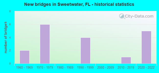
- New bridges - historical statistics
- 21960-1969
- 61970-1979
- 41990-1999
- 12010-2019
- 52020-2022

- Reconstructed bridges - Historical Statistics
- 21980-1989
- 01990-1999
- 12000-2009
- 02010-2019
- 12020-2022


- Bridge Condition - Deck
- 15.4%Excellent
- 30.8%Very good
- 46.2%Good
- 7.7%Poor

- Bridge Condition - Superstructure
- 15.4%Excellent
- 30.8%Very good
- 46.2%Good
- 7.7%Poor

- Bridge Condition - Substructure
- 30.8%Excellent
- 30.8%Very good
- 38.5%Good

- Bridge Condition - Channel
- 50.0%Very good
- 33.3%Good
- 16.7%Satisfactory
Find on map >> Show street view
Structure Number: 870214, Location: 13.4 MILES NORTH OF US 1 (Lat: 25.768183, Lng: -80.385756), Route carried "on" structure: State highway 821, Year Built: 1973, Year Reconstructed: 1992, Status: Open, Structure Length: 5.12m (16.80ft), Average Daily Traffic: 202,900 (year 2021), Truck Traffic: 8%, Average Future Daily Traffic: 239,400 (year 2042), Design Load: HS 20+Mod, Features Intersected: W FLAGLER ST
Minimum Vertical Clearance: 30+ m (98+ ft), Kilometerpoint: 42.266, Lanes on structure: 7, Lanes under structure: 4, Base Highway Network: Yes, Toll: On toll road, Owner: State Toll Authority, Approaching Roadway Width: 34.4m (112.9ft), Material/Design: Prestressed concrete, Design/Construction: Stringer/Multi-beam, Number Of Spans In Main Unit: 3, Length of Maximum Span: 24.4m (80.1ft), Curb-To-Curb Width: 34.4m (112.9ft), Out-to-Out Width: 34.9m (114.5ft)
Condition: Deck: Good, Superstructure: Good, Substructure: Good, Operating Rating: 49.4 metric tons, Method Used To Determine Operating Rating: Load and Resistance Factor (LRFR), Inventory Rating: 38.1 metric tons, Method Used To Determine Inventory Rating: Load and Resistance Factor (LRFR), Structural Evaluation: Better than present minimum criteria, Deck Geometry: Superior to present desirable criteria, Underclear: Somewhat better than minimum adequacy, Approach Roadway Alignment: Equal to present desirable criteria, Designated Inspection Frequency: Every 9 months, Inspection Date: July 2021, Deck Structure Type: Concrete Cast-file-Place
Find on map >> Show street view
Structure Number: 870264, Location: E OF SR-821/Turnpike (Lat: 25.760919, Lng: -80.384678), Route carried "on" structure: US 41, Year Built: 1964, Year Reconstructed: 1993, Status: Open, Structure Length: 1.84m (6.04ft), Average Daily Traffic: 24,250 (year 2020), Truck Traffic: 4%, Average Future Daily Traffic: 42,074 (year 2042), Design Load: HS 20, Features Intersected: SNAPPER CREEK CANAL C-2, Facility Carried by Structure: SR-90 EB (870753)
Minimum Vertical Clearance: 30+ m (98+ ft), Kilometerpoint: 9.691, Lanes on structure: 4, Owner: State Highway Agency, Approaching Roadway Width: 16.4m (53.8ft), Material/Design: Prestressed concrete, Design/Construction: Slab, Number Of Spans In Main Unit: 2, Length of Maximum Span: 9.2m (30.2ft), Curb or Sidewalk Widths: Left: 0.0m, Right: 1.9m (6.2ft), Curb-To-Curb Width: 16.4m (53.8ft), Out-to-Out Width: 19.8m (65.0ft)
Condition: Deck: Good, Superstructure: Good, Substructure: Good, Channel: Good, Operating Rating: 57.0 metric tons, Method Used To Determine Operating Rating: Load Factor (LF), Inventory Rating: 34.1 metric tons, Method Used To Determine Inventory Rating: Load Factor (LF), Structural Evaluation: Better than present minimum criteria, Deck Geometry: Meets minimum limits, Waterway Adequacy: Better than present minimum criteria, Approach Roadway Alignment: Equal to present desirable criteria, Designated Inspection Frequency: Every 24 months, Underwater Inspection Frequency: Every 24 months, Inspection Date: March 2020, Underwater Inspection Date: March 2020, Deck Structure Type: Concrete Precast Panels, Wearing Surface/Protective System: Wearing Surface: Bituminous
Find on map >> Show street view
Structure Number: 870416, Location: 13.4 MILES NORTH OF US 1 (Lat: 25.768189, Lng: -80.385439), Route carried "on" structure: State highway 821, Year Built: 1973, Year Reconstructed: 2020, Status: Open, Structure Length: 5.12m (16.80ft), Average Daily Traffic: 202,300 (year 2021), Truck Traffic: 8%, Average Future Daily Traffic: 237,400 (year 2042), Design Load: HS 20+Mod, Features Intersected: W FLAGLER ST
Minimum Vertical Clearance: 30+ m (98+ ft), Kilometerpoint: 42.266, Lanes on structure: 7, Lanes under structure: 4, Base Highway Network: Yes, Toll: On toll road, Owner: State Toll Authority, Approaching Roadway Width: 33.8m (110.9ft), Material/Design: Prestressed concrete, Design/Construction: Stringer/Multi-beam, Number Of Spans In Main Unit: 3, Length of Maximum Span: 24.4m (80.1ft), Curb-To-Curb Width: 33.8m (110.9ft), Out-to-Out Width: 35.0m (114.8ft)
Condition: Deck: Good, Superstructure: Good, Substructure: Very good, Operating Rating: 45.6 metric tons, Method Used To Determine Operating Rating: Load and Resistance Factor (LRFR), Inventory Rating: 35.2 metric tons, Method Used To Determine Inventory Rating: Load and Resistance Factor (LRFR), Structural Evaluation: Better than present minimum criteria, Deck Geometry: Superior to present desirable criteria, Underclear: Somewhat better than minimum adequacy, Approach Roadway Alignment: Equal to present desirable criteria, Designated Inspection Frequency: Every 9 months, Inspection Date: July 2021, Deck Structure Type: Concrete Cast-file-Place
Find on map >> Show street view
Structure Number: 870753, Location: EAST of SR-821/Turnpike (Lat: 25.761092, Lng: -80.384681), Route carried "on" structure: US 41, Year Built: 1994, Status: Open, Structure Length: 1.84m (6.04ft), Average Daily Traffic: 24,250 (year 2020), Truck Traffic: 4%, Average Future Daily Traffic: 42,074 (year 2042), Design Load: HS 20, Features Intersected: SNAPPER CREEK CANAL C-2, Facility Carried by Structure: SR-90 WB (870264)
Minimum Vertical Clearance: 30+ m (98+ ft), Kilometerpoint: 9.691, Lanes on structure: 3, Owner: State Highway Agency, Approaching Roadway Width: 13.3m (43.6ft), Material/Design: Concrete, Design/Construction: Slab, Number Of Spans In Main Unit: 2, Length of Maximum Span: 9.2m (30.2ft), Curb-To-Curb Width: 13.3m (43.6ft), Out-to-Out Width: 14.2m (46.6ft)
Condition: Deck: Very good, Superstructure: Very good, Substructure: Very good, Channel: Very good, Operating Rating: 62.1 metric tons, Method Used To Determine Operating Rating: Load Factor (LF), Inventory Rating: 37.2 metric tons, Method Used To Determine Inventory Rating: Load Factor (LF), Structural Evaluation: Equal to present desirable criteria, Deck Geometry: Somewhat better than minimum adequacy, Waterway Adequacy: Equal to present desirable criteria, Approach Roadway Alignment: Equal to present desirable criteria, Designated Inspection Frequency: Every 24 months, Underwater Inspection Frequency: Every 24 months, Inspection Date: March 2020, Underwater Inspection Date: March 2020, Deck Structure Type: Concrete Cast-file-Place, Wearing Surface/Protective System: Wearing Surface: Monolithic Concrete
Find on map >> Show street view
Structure Number: 870754, Location: 13.4 MILES NORTH OF US-1 (Lat: 25.768175, Lng: -80.386292), Route carried "on" structure: Ramp State highway 821, Year Built: 1992, Year Reconstructed: 2005, Status: Open, Structure Length: 5.12m (16.80ft), Average Daily Traffic: 9,100 (year 2020), Truck Traffic: 8%, Average Future Daily Traffic: 15,788 (year 2042), Design Load: HS 20+Mod, Features Intersected: W FLAGLER ST
Minimum Vertical Clearance: 30+ m (98+ ft), Kilometerpoint: 0.377, Lanes on structure: 2, Lanes under structure: 5, Base Highway Network: Yes, Toll: On toll road, Owner: State Toll Authority, Approaching Roadway Width: 13.7m (44.9ft), Material/Design: Prestressed concrete, Design/Construction: Stringer/Multi-beam, Number Of Spans In Main Unit: 3, Length of Maximum Span: 25.0m (82.0ft), Curb-To-Curb Width: 12.8m (42.0ft), Out-to-Out Width: 13.7m (44.9ft)
Condition: Deck: Good, Superstructure: Good, Substructure: Excellent, Operating Rating: 38.6 metric tons, Method Used To Determine Operating Rating: Load and Resistance Factor (LRFR), Inventory Rating: 29.8 metric tons, Method Used To Determine Inventory Rating: Load and Resistance Factor (LRFR), Structural Evaluation: Better than present minimum criteria, Deck Geometry: Superior to present desirable criteria, Underclear: Somewhat better than minimum adequacy, Approach Roadway Alignment: Equal to present desirable criteria, Designated Inspection Frequency: Every 24 months, Inspection Date: April 2020, Deck Structure Type: Concrete Cast-file-Place
Find on map >> Show street view
Structure Number: 870924, Location: 0.9 MILES NORTH OF US 41 (Lat: 25.774136, Lng: -80.385514), Route carried "on" structure: Ramp State highway 836, Year Built: 2021, Status: Not yet open, Structure Length: 12.86m (42.19ft), Average Daily Traffic: 36,500 (year 2021), Truck Traffic: 5%, Average Future Daily Traffic: 48,800 (year 2042), Design Load: HL 93, Features Intersected: SR821 NB HEFT
Minimum Vertical Clearance: 5.18m (16.99ft), Kilometerpoint: 42.648, Lanes on structure: 1, Lanes under structure: 6, Base Highway Network: Yes, Toll: On toll road, Owner: State Toll Authority, Approaching Roadway Width: 11.3m (37.1ft), Skew: 1 degrees, Material/Design: Steel continuous, Design/Construction: Stringer/Multi-beam, Number Of Spans In Main Unit: 2, Length of Maximum Span: 64.3m (211.0ft), Curb-To-Curb Width: 11.3m (37.1ft), Out-to-Out Width: 12.2m (40.0ft)
Condition: Deck: Very good, Superstructure: Very good, Substructure: Very good, Operating Rating: 51.3 metric tons, Method Used To Determine Operating Rating: Load and Resistance Factor (LRFR), Inventory Rating: 39.6 metric tons, Method Used To Determine Inventory Rating: Load and Resistance Factor (LRFR), Structural Evaluation: Equal to present desirable criteria, Deck Geometry: Superior to present desirable criteria, Underclear: Equal to present minimum criteria, Approach Roadway Alignment: Better than present minimum criteria, Designated Inspection Frequency: Every 9 months, Critical Feature Inspection Frequency: Every 9 months, Inspection Date: July 2021, Critical Feature Inspection Date: July 2021, Deck Structure Type: Concrete Cast-file-Place
Find on map >> Show street view
Structure Number: 870927, Location: SR 821 SB HEFT (Lat: 25.761386, Lng: -80.387389), Route carried "on" structure: Ramp State highway 821, Year Built: 2021, Status: Open, Structure Length: 2.83m (9.28ft), Average Daily Traffic: 10,300 (year 2021), Truck Traffic: 8%, Average Future Daily Traffic: 13,900 (year 2042), Design Load: HL 93, Features Intersected: TAMIAMI CANAL
Minimum Vertical Clearance: 30+ m (98+ ft), Kilometerpoint: 1.156, Lanes on structure: 3, Toll: On toll road, Owner: State Toll Authority, Approaching Roadway Width: 16.8m (55.1ft), Skew: 2 degrees, Material/Design: Concrete, Design/Construction: Slab, Number Of Spans In Main Unit: 3, Length of Maximum Span: 9.7m (31.8ft), Curb-To-Curb Width: 16.8m (55.1ft), Out-to-Out Width: 16.8m (55.1ft)
Condition: Deck: Very good, Superstructure: Very good, Substructure: Good, Channel: Good, Operating Rating: 49.4 metric tons, Method Used To Determine Operating Rating: Load and Resistance Factor (LRFR), Inventory Rating: 38.2 metric tons, Method Used To Determine Inventory Rating: Load and Resistance Factor (LRFR), Structural Evaluation: Better than present minimum criteria, Deck Geometry: Superior to present desirable criteria, Waterway Adequacy: Better than present minimum criteria, Approach Roadway Alignment: Equal to present desirable criteria, Designated Inspection Frequency: Every 9 months, Underwater Inspection Frequency: Every 9 months, Inspection Date: July 2021, Underwater Inspection Date: July 2021, Deck Structure Type: Concrete Cast-file-Place
Find on map >> Show street view
Structure Number: 870929, Location: SR 836 / HEFT Intchg (Lat: 25.775681, Lng: -80.385597), Route carried "on" structure: Ramp State highway 836, Year Built: 2021, Status: Open, Structure Length: 12.25m (40.19ft), Average Daily Traffic: 36,500 (year 2021), Truck Traffic: 5%, Average Future Daily Traffic: 48,800 (year 2042), Design Load: HL 93, Features Intersected: SR821 NB HEFT
Minimum Vertical Clearance: 30+ m (98+ ft), Kilometerpoint: 0.805, Lanes on structure: 1, Lanes under structure: 6, Base Highway Network: Yes, Toll: On toll road, Owner: State Toll Authority, Approaching Roadway Width: 10.7m (35.1ft), Material/Design: Steel continuous, Design/Construction: Box Beam or Girders - Multiple, Number Of Spans In Main Unit: 2, Length of Maximum Span: 63.1m (207.0ft), Curb-To-Curb Width: 10.7m (35.1ft), Out-to-Out Width: 11.8m (38.7ft)
Condition: Deck: Excellent, Superstructure: Excellent, Substructure: Excellent, Operating Rating: 51.9 metric tons, Method Used To Determine Operating Rating: Load and Resistance Factor (LRFR), Inventory Rating: 39.8 metric tons, Method Used To Determine Inventory Rating: Load and Resistance Factor (LRFR), Structural Evaluation: Superior to present desirable criteria, Deck Geometry: Superior to present desirable criteria, Underclear: Equal to present minimum criteria, Approach Roadway Alignment: Better than present minimum criteria, Designated Inspection Frequency: Every 9 months, Critical Feature Inspection Frequency: Every 9 months, Inspection Date: July 2021, Critical Feature Inspection Date: July 2021, Deck Structure Type: Concrete Cast-file-Place
Find on map >> Show street view
Structure Number: 87109, Location: 50 ft N of SR 90 / US41 (Lat: 25.761617, Lng: -80.368528), Route carried "on" structure: State highway 985, Year Built: 2017, Status: Open, Structure Length: 2.51m (8.23ft), Average Daily Traffic: 28,000 (year 2020), Truck Traffic: 4%, Average Future Daily Traffic: 48,580 (year 2042), Design Load: Greater than HL93, Features Intersected: Tamiami Canal C-4
Minimum Vertical Clearance: 30+ m (98+ ft), Kilometerpoint: 9.943, Lanes on structure: 9, Owner: State Highway Agency, Approaching Roadway Width: 43.4m (142.4ft), Skew: 10 degrees, Material/Design: Concrete, Design/Construction: Slab, Number Of Spans In Main Unit: 3, Length of Maximum Span: 11.1m (36.4ft), Curb or Sidewalk Widths: Left: 2.4m (7.9ft), Right: 1.5m (4.9ft), Curb-To-Curb Width: 43.4m (142.4ft), Out-to-Out Width: 49.0m (160.8ft)
Condition: Deck: Excellent, Superstructure: Excellent, Substructure: Excellent, Channel: Very good, Operating Rating: 49.0 metric tons, Method Used To Determine Operating Rating: Load and Resistance Factor (LRFR), Inventory Rating: 37.6 metric tons, Method Used To Determine Inventory Rating: Load and Resistance Factor (LRFR), Structural Evaluation: Superior to present desirable criteria, Deck Geometry: Superior to present desirable criteria, Waterway Adequacy: Equal to present desirable criteria, Approach Roadway Alignment: Equal to present desirable criteria, Designated Inspection Frequency: Every 24 months, Underwater Inspection Frequency: Every 24 months, Inspection Date: August 2021, Underwater Inspection Date: August 2021, Deck Structure Type: Concrete Cast-file-Place, Wearing Surface/Protective System: Wearing Surface: Monolithic Concrete
Find on map >> Show street view
Structure Number: 874235, Location: 300 ft. E/O SW 99th Ct. (Lat: 25.754414, Lng: -80.356261), Route carried "on" structure: County highway , Year Built: 1960, Status: Open, Structure Length: 0.82m (2.69ft), Average Daily Traffic: 3,274 (year 2014), Truck Traffic: 5%, Average Future Daily Traffic: 4,447 (year 2036), Design Load: HS 20, Features Intersected: Westbrook Canal, Facility Carried by Structure: SW 16th Street
Minimum Vertical Clearance: 30.45m (99.90ft), Kilometerpoint: 1.197, Lanes on structure: 2, Owner: County Highway Agency, Approaching Roadway Width: 7.0m (23.0ft), Material/Design: Concrete, Design/Construction: Slab, Number Of Spans In Main Unit: 1, Length of Maximum Span: 8.2m (26.9ft), Curb or Sidewalk Widths: Left: 1.5m (4.9ft), Right: 1.5m (4.9ft), Curb-To-Curb Width: 8.5m (27.9ft), Out-to-Out Width: 11.6m (38.1ft)
Condition: Deck: Very good, Superstructure: Very good, Substructure: Excellent, Channel: Very good, Operating Rating: 72.7 metric tons, Method Used To Determine Operating Rating: Load Factor (LF), Inventory Rating: 43.5 metric tons, Method Used To Determine Inventory Rating: Load Factor (LF), Structural Evaluation: Equal to present desirable criteria, Deck Geometry: Meets minimum limits, Waterway Adequacy: Better than present minimum criteria, Approach Roadway Alignment: Equal to present desirable criteria, Designated Inspection Frequency: Every 24 months, Inspection Date: September 2021, Deck Structure Type: Concrete Cast-file-Place, Wearing Surface/Protective System: Wearing Surface: Monolithic Concrete
Find on map >> Show street view
Structure Number: 874613, Location: 300Ft. E of NW 97th Ave. (Lat: 25.775619, Lng: -80.351533), Route carried "on" structure: County highway , Year Built: 1970, Status: Open, Structure Length: 1.04m (3.41ft), Average Daily Traffic: 5,466 (year 2020), Truck Traffic: 3%, Average Future Daily Traffic: 6,242 (year 2042), Design Load: HS 20, Features Intersected: Golf Cart Path, Facility Carried by Structure: Fountainebleau EB
Minimum Vertical Clearance: 30+ m (98+ ft), Kilometerpoint: 3.423, Lanes on structure: 2, Owner: County Highway Agency, Approaching Roadway Width: 7.0m (23.0ft), Material/Design: Prestressed concrete, Design/Construction: Slab, Number Of Spans In Main Unit: 1, Length of Maximum Span: 10.4m (34.1ft), Curb or Sidewalk Widths: Left: 0.6m (2.0ft), Right: 1.7m (5.6ft), Curb-To-Curb Width: 8.2m (26.9ft), Out-to-Out Width: 11.1m (36.4ft)
Condition: Deck: Poor, Superstructure: Poor, Substructure: Very good, Operating Rating: 44.4 metric tons, Method Used To Determine Operating Rating: Load Factor (LF), Inventory Rating: 26.6 metric tons, Method Used To Determine Inventory Rating: Load Factor (LF), Structural Evaluation: Meets minimum limits, Deck Geometry: High priority of corrective action, Approach Roadway Alignment: Equal to present desirable criteria, Designated Inspection Frequency: Every 24 months, Other Special Inspection Frequency: Every 12 months, Inspection Date: May 2020, Other Special Inspection Date: May 2021, Deck Structure Type: Concrete Precast Panels, Wearing Surface/Protective System: Wearing Surface: Bituminous
Find on map >> Show street view
Structure Number: 874614, Location: 300Ft. E of NW 97th Ave. (Lat: 25.775806, Lng: -80.351500), Route carried "on" structure: County highway , Year Built: 1970, Status: Open, Structure Length: 1.04m (3.41ft), Average Daily Traffic: 5,566 (year 2014), Truck Traffic: 3%, Average Future Daily Traffic: 6,242 (year 2039), Design Load: HS 20, Features Intersected: Golf Cart Path, Facility Carried by Structure: Fountainebleau WB
Minimum Vertical Clearance: 30+ m (98+ ft), Kilometerpoint: 3.423, Lanes on structure: 2, Owner: County Highway Agency, Approaching Roadway Width: 7.0m (23.0ft), Material/Design: Prestressed concrete, Design/Construction: Slab, Number Of Spans In Main Unit: 1, Length of Maximum Span: 10.4m (34.1ft), Curb or Sidewalk Widths: Left: 1.8m (5.9ft), Right: 0.6m (2.0ft), Curb-To-Curb Width: 8.2m (26.9ft), Out-to-Out Width: 11.2m (36.7ft)
Condition: Deck: Good, Superstructure: Good, Substructure: Good, Operating Rating: 44.4 metric tons, Method Used To Determine Operating Rating: Load Factor (LF), Inventory Rating: 26.6 metric tons, Method Used To Determine Inventory Rating: Load Factor (LF), Structural Evaluation: Equal to present minimum criteria, Deck Geometry: High priority of corrective action, Approach Roadway Alignment: Equal to present desirable criteria, Designated Inspection Frequency: Every 24 months, Inspection Date: May 2020, Deck Structure Type: Concrete Precast Panels, Wearing Surface/Protective System: Wearing Surface: Bituminous
Find on map >> Show street view
Structure Number: 878101, Location: 50Ft. N of US41/SW 8th St (Lat: 25.761500, Lng: -80.372417), Route carried "on" structure: City street , Year Built: 1995, Status: Open, Structure Length: 2.26m (7.41ft), Average Daily Traffic: 5,182 (year 2020), Truck Traffic: 3%, Average Future Daily Traffic: 6,120 (year 2042), Design Load: HS 20, Features Intersected: Tamiami Canal, Facility Carried by Structure: SW 109th Avenue
Minimum Vertical Clearance: 30+ m (98+ ft), Kilometerpoint: 0.026, Lanes on structure: 4, Owner: City or Municipal Highway Agency, Approaching Roadway Width: 12.5m (41.0ft), Material/Design: Concrete continuous, Design/Construction: Slab, Number Of Spans In Main Unit: 3, Length of Maximum Span: 10.4m (34.1ft), Curb or Sidewalk Widths: Left: 2.2m (7.2ft), Right: 0.0m, Curb-To-Curb Width: 15.5m (50.9ft), Out-to-Out Width: 18.8m (61.7ft)
Condition: Deck: Good, Superstructure: Good, Substructure: Good, Channel: Satisfactory, Operating Rating: 65.0 metric tons, Method Used To Determine Operating Rating: Load Factor (LF), Inventory Rating: 39.3 metric tons, Method Used To Determine Inventory Rating: Load Factor (LF), Structural Evaluation: Better than present minimum criteria, Deck Geometry: Meets minimum limits, Waterway Adequacy: Equal to present desirable criteria, Approach Roadway Alignment: Better than present minimum criteria, Designated Inspection Frequency: Every 24 months, Underwater Inspection Frequency: Every 24 months, Inspection Date: June 2020, Underwater Inspection Date: June 2020, Deck Structure Type: Concrete Cast-file-Place
Find on map >> Show street view
Structure Number: 870214, Location: 13.4 MILES NORTH OF US 1 (Lat: 25.768183, Lng: -80.385756), Route carried "under" structure: City street 968, Year Built: 1973, Structure Length: 0. m, Average Daily Traffic: 24,500 (year 2021), Truck Traffic: 8%, Features Intersected: W FLAGLER ST, Facility Carried by Structure: SR821 SB HEFT 26.1
Minimum Vertical Clearance: 4.97m (16.31ft), Kilometerpoint: 42.118, Lanes on structure: 7, Lanes under structure: 4, Material/Design: Prestressed concrete, Design/Construction: Stringer/Multi-beam, Length of Maximum Span: 24.4m (80.1ft)
Find on map >> Show street view
Structure Number: 870416, Location: 13.4 MILES NORTH OF US 1 (Lat: 25.768189, Lng: -80.385439), Route carried "under" structure: City street 968, Year Built: 1973, Structure Length: 0. m, Average Daily Traffic: 24,500 (year 2021), Truck Traffic: 8%, Features Intersected: W FLAGLER ST, Facility Carried by Structure: SR821 NB HEFT 26.1
Minimum Vertical Clearance: 5.18m (16.99ft), Kilometerpoint: 42.118, Lanes on structure: 7, Lanes under structure: 4, Material/Design: Prestressed concrete, Design/Construction: Stringer/Multi-beam, Length of Maximum Span: 24.4m (80.1ft)
Find on map >> Show street view
Structure Number: 870754, Location: 13.4 MILES NORTH OF US-1 (Lat: 25.768175, Lng: -80.386292), Route carried "under" structure: County highway , Year Built: 1992, Structure Length: 0. m, Average Daily Traffic: 9,100 (year 2020), Truck Traffic: 8%, Features Intersected: W FLAGLER ST, Facility Carried by Structure: SR821 SB HEFT 26.1
Minimum Vertical Clearance: 5.18m (16.99ft), Kilometerpoint: 0.264, Lanes on structure: 2, Lanes under structure: 4, Material/Design: Prestressed concrete, Design/Construction: Stringer/Multi-beam, Length of Maximum Span: 25.0m (82.0ft)
Find on map >> Show street view
Structure Number: 870924, Location: 0.9 MILES NORTH OF US 41 (Lat: 25.774136, Lng: -80.385514), Route carried "under" structure: State highway 821, Year Built: 2021, Structure Length: 0. m, Average Daily Traffic: 166,900 (year 2021), Features Intersected: SR821 NB HEFT, Facility Carried by Structure: SR 836 EB 26.4
Minimum Vertical Clearance: 5.18m (16.99ft), Kilometerpoint: 43.372, Lanes on structure: 1, Lanes under structure: 6, Toll: On toll road, Material/Design: Steel continuous, Design/Construction: Stringer/Multi-beam, Length of Maximum Span: 64.3m (211.0ft)
Find on map >> Show street view
Structure Number: 870929, Location: SR 836 / HEFT Intchg (Lat: 25.775681, Lng: -80.385597), Route carried "under" structure: State highway 821, Year Built: 2021, Structure Length: 0. m, Average Daily Traffic: 166,900 (year 2021), Truck Traffic: 5%, Features Intersected: SR821 NB HEFT, Facility Carried by Structure: SR 836 WB 26.5
Minimum Vertical Clearance: 5.85m (19.19ft), Kilometerpoint: 42.648, Lanes on structure: 1, Lanes under structure: 6, Toll: On toll road, Material/Design: Steel continuous, Design/Construction: Box Beam or Girders - Multiple, Length of Maximum Span: 63.1m (207.0ft)