Bridge Statistics for Suwanee, Georgia (GA)
Condition, Traffic, Stress, Structural Evaluation, Project Costs
- National Bridge Inventory (NBI) Statistics
- 40Number of bridges
- 591ft / 180mTotal length
- $132,950,000Total costs
- 1,307,730Total average daily traffic
- 210,031Total average daily truck traffic
- National Bridge Inventory (NBI) Registered Bridges for Suwanee
- No street view available for this location
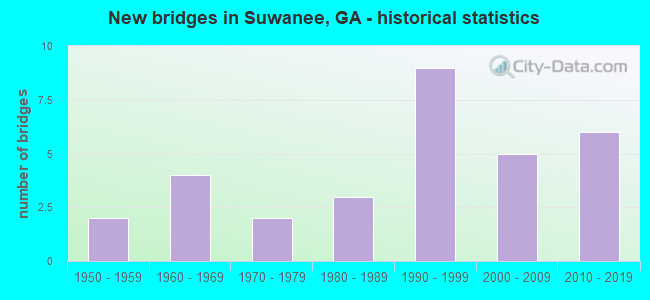
- New bridges - historical statistics
- 21950-1959
- 41960-1969
- 21970-1979
- 31980-1989
- 91990-1999
- 52000-2009
- 62010-2019

- Reconstructed bridges - Historical Statistics
- 11980-1989
- 01990-1999
- 12000-2009


- Bridge Condition - Deck
- 12.5%Very good
- 70.8%Good
- 16.7%Satisfactory

- Bridge Condition - Superstructure
- 45.8%Very good
- 50.0%Good
- 4.2%Satisfactory

- Bridge Condition - Substructure
- 20.8%Very good
- 54.2%Good
- 16.7%Satisfactory
- 8.3%Fair

- Bridge Condition - Channel
- 47.6%Very good
- 23.8%Good
- 14.3%Satisfactory
- 14.3%Fair

- Bridge Condition - Culverts
- 14.3%Very good
- 71.4%Good
- 14.3%Satisfactory
Find on map >> Show street view
Structure Number: 135004, Location: 2.7 MI N OF AUBURN (Lat: 34.049419, Lng: -83.815469), Route carried "on" structure: County highway 38, Year Built: 1965, Status: Open, Structure Length: 0.98m (3.22ft), Average Daily Traffic: 490 (year 2012), Truck Traffic: 1%, Average Future Daily Traffic: 735 (year 2032), Design Load: H 15, Features Intersected: ROCK CREEK, Facility Carried by Structure: DEE KENNEDY ROAD
Minimum Vertical Clearance: 30+ m (98+ ft), Kilometerpoint: 4.828, Lanes on structure: 2, Base Highway Network: Yes, Owner: County Highway Agency, Approaching Roadway Width: 6.1m (20.0ft), Material/Design: Concrete, Design/Construction: Culvert, Number Of Spans In Main Unit: 3, Length of Maximum Span: 3.0m (9.8ft)
Condition: Channel: Very good, Culverts: Good, Inventory Rating: 59.8 metric tons, Method Used To Determine Inventory Rating: Load Factor (LF), Structural Evaluation: Better than present minimum criteria, Waterway Adequacy: Better than present minimum criteria, Approach Roadway Alignment: Equal to present desirable criteria, Designated Inspection Frequency: Every 24 months, Inspection Date: March 2021, Bridge Improvement Cost: $125,000, Roadway Improvement Cost: $13,000, Total Project Cost: $188,000
Find on map >> Show street view
Structure Number: 1350011, Location: .5 MI S OF SUWANEE (Lat: 34.032408, Lng: -84.089308), Route carried "on" structure: US 23, Year Built: 1973, Status: Open, Structure Length: 10.42m (34.19ft), Average Daily Traffic: 13,150 (year 2012), Truck Traffic: 1%, Average Future Daily Traffic: 19,725 (year 2032), Design Load: HS 20+Mod, Features Intersected: SUWANEE CREEK, Facility Carried by Structure: BUFORD HIGHWAY-US2
Minimum Vertical Clearance: 30+ m (98+ ft), Kilometerpoint: 20.921, Lanes on structure: 2, Base Highway Network: Yes, Owner: State Highway Agency, Approaching Roadway Width: 8.5m (27.9ft), Skew: 3 degrees, Material/Design: Concrete, Design/Construction: Tee Beam, Number Of Spans In Main Unit: 9, Length of Maximum Span: 11.6m (38.1ft), Curb-To-Curb Width: 10.6m (34.8ft), Out-to-Out Width: 11.7m (38.4ft)
Condition: Deck: Satisfactory, Superstructure: Good, Substructure: Satisfactory, Channel: Good, Operating Rating: 35.3 metric tons, Method Used To Determine Operating Rating: Load Factor (LF), Inventory Rating: 20.8 metric tons, Method Used To Determine Inventory Rating: Load Factor (LF), Structural Evaluation: Somewhat better than minimum adequacy, Deck Geometry: Meets minimum limits, Waterway Adequacy: Equal to present desirable criteria, Approach Roadway Alignment: Equal to present desirable criteria, Designated Inspection Frequency: Every 24 months, Inspection Date: December 2021, Bridge Improvement Cost: $1,336,000, Roadway Improvement Cost: $134,000, Total Project Cost: $2,004,000, Deck Structure Type: Concrete Cast-file-Place
Find on map >> Show street view
Structure Number: 1350043, Location: IN SUWANEE (Lat: 34.051317, Lng: -84.059869), Route carried "on" structure: State highway 317, Year Built: 1959, Year Reconstructed: 1993, Status: Open, Structure Length: 2.56m (8.40ft), Average Daily Traffic: 29,760 (year 2012), Truck Traffic: 4%, Average Future Daily Traffic: 44,640 (year 2032), Design Load: HS 20, Features Intersected: SUWANEE CREEK
Minimum Vertical Clearance: 30+ m (98+ ft), Kilometerpoint: 3.219, Lanes on structure: 4, Base Highway Network: Yes, Owner: State Highway Agency, Approaching Roadway Width: 18.3m (60.0ft), Skew: 29 degrees, Material/Design: Concrete, Design/Construction: Tee Beam, Number Of Spans In Main Unit: 3, Length of Maximum Span: 8.5m (27.9ft), Curb-To-Curb Width: 26.9m (88.3ft), Out-to-Out Width: 28.7m (94.2ft)
Condition: Deck: Good, Superstructure: Good, Substructure: Fair, Channel: Fair, Operating Rating: 38.1 metric tons, Method Used To Determine Operating Rating: Load Factor (LF), Inventory Rating: 22.6 metric tons, Method Used To Determine Inventory Rating: Load Factor (LF), Structural Evaluation: Somewhat better than minimum adequacy, Deck Geometry: Superior to present desirable criteria, Waterway Adequacy: Equal to present minimum criteria, Approach Roadway Alignment: Better than present minimum criteria, Length Of Structure Improvement: 42.79m (140.39ft), Designated Inspection Frequency: Every 24 months, Underwater Inspection Frequency: Every 60 months, Inspection Date: December 2021, Underwater Inspection Date: April 2019, Bridge Improvement Cost: $507,000, Roadway Improvement Cost: $51,000, Total Project Cost: $761,000, Deck Structure Type: Concrete Cast-file-Place
Find on map >> Show street view
Structure Number: 1350046, Location: 2.3 MI E OF SUWANEE (Lat: 34.047606, Lng: -84.028675), Route carried "on" structure: Interstate 985, Year Built: 1965, Status: Open, Structure Length: 5.49m (18.01ft), Average Daily Traffic: 56,340 (year 2012), Truck Traffic: 8%, Average Future Daily Traffic: 84,510 (year 2032), Design Load: HS 20, Features Intersected: IVY CREEK
Minimum Vertical Clearance: 30+ m (98+ ft), Kilometerpoint: 0.000, Lanes on structure: 2, Base Highway Network: Yes, Owner: State Highway Agency, Approaching Roadway Width: 11.6m (38.1ft), Skew: 19 degrees, Material/Design: Steel, Design/Construction: Stringer/Multi-beam, Number Of Spans In Main Unit: 3, Length of Maximum Span: 22.9m (75.1ft), Curb or Sidewalk Widths: Left: 0.6m (2.0ft), Right: 0.6m (2.0ft), Curb-To-Curb Width: 8.5m (27.9ft), Out-to-Out Width: 10.4m (34.1ft)
Condition: Deck: Satisfactory, Superstructure: Good, Substructure: Good, Channel: Good, Operating Rating: 34.4 metric tons, Method Used To Determine Operating Rating: Load Factor (LF), Inventory Rating: 19.9 metric tons, Method Used To Determine Inventory Rating: Load Factor (LF), Structural Evaluation: Somewhat better than minimum adequacy, Deck Geometry: High priority of replacement, Waterway Adequacy: Equal to present desirable criteria, Approach Roadway Alignment: Better than present minimum criteria, Length Of Structure Improvement: 11.61m (38.09ft), Designated Inspection Frequency: Every 24 months, Inspection Date: November 2021, Bridge Improvement Cost: $703,000, Roadway Improvement Cost: $70,000, Total Project Cost: $1,055,000, Deck Structure Type: Concrete Cast-file-Place
Find on map >> Show street view
Structure Number: 1350047, Location: 2.3 MI E OF SUWANEE (Lat: 34.047503, Lng: -84.029281), Route carried "on" structure: Interstate 985, Year Built: 1965, Status: Open, Structure Length: 6.37m (20.90ft), Average Daily Traffic: 56,340 (year 2012), Truck Traffic: 8%, Average Future Daily Traffic: 84,510 (year 2032), Design Load: HS 20, Features Intersected: IVY CREEK
Minimum Vertical Clearance: 30+ m (98+ ft), Kilometerpoint: 0.000, Lanes on structure: 2, Base Highway Network: Yes, Owner: State Highway Agency, Approaching Roadway Width: 11.6m (38.1ft), Skew: 19 degrees, Material/Design: Steel continuous, Design/Construction: Stringer/Multi-beam, Number Of Spans In Main Unit: 3, Length of Maximum Span: 22.6m (74.1ft), Curb or Sidewalk Widths: Left: 0.6m (2.0ft), Right: 0.6m (2.0ft), Curb-To-Curb Width: 8.5m (27.9ft), Out-to-Out Width: 10.3m (33.8ft)
Condition: Deck: Satisfactory, Superstructure: Good, Substructure: Satisfactory, Channel: Good, Operating Rating: 33.5 metric tons, Method Used To Determine Operating Rating: Load Factor (LF), Inventory Rating: 19.9 metric tons, Method Used To Determine Inventory Rating: Load Factor (LF), Structural Evaluation: Somewhat better than minimum adequacy, Deck Geometry: High priority of corrective action, Waterway Adequacy: Superior to present desirable criteria, Approach Roadway Alignment: Better than present minimum criteria, Length Of Structure Improvement: 12.98m (42.59ft), Designated Inspection Frequency: Every 24 months, Inspection Date: November 2021, Bridge Improvement Cost: $817,000, Roadway Improvement Cost: $82,000, Total Project Cost: $1,225,000, Deck Structure Type: Concrete Cast-file-Place
Find on map >> Show street view
Structure Number: 1350133, Location: IN SOUTH SUWANNE (Lat: 34.030050, Lng: -84.048319), Route carried "on" structure: State highway 317, Year Built: 1994, Status: Open, Structure Length: 6.43m (21.10ft), Average Daily Traffic: 40,670 (year 2012), Truck Traffic: 1%, Average Future Daily Traffic: 61,005 (year 2032), Design Load: HS 20+Mod, Features Intersected: I-85 (SR 403)
Minimum Vertical Clearance: 30+ m (98+ ft), Kilometerpoint: 0.000, Lanes on structure: 7, Lanes under structure: 8, Owner: State Highway Agency, Approaching Roadway Width: 23.2m (76.1ft), Material/Design: Prestressed concrete, Design/Construction: Stringer/Multi-beam, Number Of Spans In Main Unit: 2, Length of Maximum Span: 32.3m (106.0ft), Curb or Sidewalk Widths: Left: 1.8m (5.9ft), Right: 1.8m (5.9ft), Curb-To-Curb Width: 23.2m (76.1ft), Out-to-Out Width: 27.6m (90.6ft)
Condition: Deck: Good, Superstructure: Good, Substructure: Good, Operating Rating: 63.5 metric tons, Method Used To Determine Operating Rating: Load Factor (LF), Inventory Rating: 38.1 metric tons, Method Used To Determine Inventory Rating: Load Factor (LF), Structural Evaluation: Better than present minimum criteria, Deck Geometry: High priority of replacement, Underclear: Equal to present minimum criteria, Approach Roadway Alignment: Equal to present desirable criteria, Designated Inspection Frequency: Every 24 months, Inspection Date: January 2022, Bridge Improvement Cost: $1,949,000, Roadway Improvement Cost: $195,000, Total Project Cost: $2,923,000, Deck Structure Type: Concrete Cast-file-Place
Find on map >> Show street view
Structure Number: 1355001, Location: DULUTH - EAST SECTION (Lat: 34.010236, Lng: -84.132236), Route carried "on" structure: County highway 2, Year Built: 1994, Status: Open, Structure Length: 5.67m (18.60ft), Average Daily Traffic: 1,930 (year 2012), Truck Traffic: 1%, Average Future Daily Traffic: 2,895 (year 2032), Design Load: HS 20+Mod, Features Intersected: NS RAILROAD, Facility Carried by Structure: ROGERS BRIDGE ROAD
Minimum Vertical Clearance: 30+ m (98+ ft), Kilometerpoint: 0.000, Lanes on structure: 2, Owner: County Highway Agency, Approaching Roadway Width: 12.2m (40.0ft), Skew: 3 degrees, Material/Design: Prestressed concrete, Design/Construction: Stringer/Multi-beam, Number Of Spans In Main Unit: 3, Length of Maximum Span: 19.8m (65.0ft), Curb or Sidewalk Widths: Left: 1.3m (4.3ft), Right: 0.0m, Curb-To-Curb Width: 11.0m (36.1ft), Out-to-Out Width: 13.2m (43.3ft)
Condition: Deck: Good, Superstructure: Very good, Substructure: Good, Operating Rating: 46.2 metric tons, Method Used To Determine Operating Rating: Allowable Stress (AS), Inventory Rating: 32.6 metric tons, Method Used To Determine Inventory Rating: Allowable Stress (AS), Structural Evaluation: Better than present minimum criteria, Deck Geometry: Equal to present minimum criteria, Underclear: Superior to present desirable criteria, Approach Roadway Alignment: Better than present minimum criteria, Designated Inspection Frequency: Every 24 months, Inspection Date: Febuary 2022, Bridge Improvement Cost: $727,000, Roadway Improvement Cost: $73,000, Total Project Cost: $1,090,000, Deck Structure Type: Concrete Cast-file-Place
Find on map >> Show street view
Structure Number: 1355002, Location: 2.5 MI NW OF SUWANEE (Lat: 34.084639, Lng: -84.094192), Route carried "on" structure: County highway 21, Year Built: 1982, Status: Open, Structure Length: 1.01m (3.31ft), Average Daily Traffic: 70 (year 2012), Truck Traffic: 1%, Average Future Daily Traffic: 105 (year 2032), Design Load: HS 20+Mod, Features Intersected: LEVEL CREEK, Facility Carried by Structure: SETTLES BRIDGE ROA
Minimum Vertical Clearance: 30+ m (98+ ft), Kilometerpoint: 3.219, Lanes on structure: 2, Base Highway Network: Yes, Owner: County Highway Agency, Approaching Roadway Width: 8.2m (26.9ft), Skew: 3 degrees, Material/Design: Concrete, Design/Construction: Culvert, Number Of Spans In Main Unit: 3, Length of Maximum Span: 3.0m (9.8ft)
Condition: Channel: Very good, Culverts: Good, Structural Evaluation: Better than present minimum criteria, Waterway Adequacy: Superior to present desirable criteria, Approach Roadway Alignment: Equal to present minimum criteria, Designated Inspection Frequency: Every 24 months, Inspection Date: November 2021, Bridge Improvement Cost: $129,000, Roadway Improvement Cost: $13,000, Total Project Cost: $193,000
Find on map >> Show street view
Structure Number: 1355004, Location: IN SUWANEE (Lat: 34.045419, Lng: -84.064250), Route carried "on" structure: City street 833, Year Built: 1978, Status: Posted for load, Structure Length: 3.35m (10.99ft), Average Daily Traffic: 1,930 (year 2012), Truck Traffic: 1%, Average Future Daily Traffic: 2,895 (year 2032), Design Load: HS 15, Features Intersected: SUWANEE CREEK, Facility Carried by Structure: MARTIN FARM ROAD
Minimum Vertical Clearance: 30+ m (98+ ft), Kilometerpoint: 1.609, Lanes on structure: 2, Base Highway Network: Yes, Owner: City or Municipal Highway Agency, Approaching Roadway Width: 7.0m (23.0ft), Material/Design: Concrete, Design/Construction: Slab, Number Of Spans In Main Unit: 6, Length of Maximum Span: 6.1m (20.0ft), Curb-To-Curb Width: 8.7m (28.5ft), Out-to-Out Width: 9.8m (32.2ft)
Condition: Deck: Good, Superstructure: Good, Substructure: Fair, Channel: Fair, Operating Rating: 12.7 metric tons, Method Used To Determine Operating Rating: Load Factor (LF), Inventory Rating: 5.4 metric tons, Method Used To Determine Inventory Rating: Load Factor (LF), Structural Evaluation: High priority of corrective action, Deck Geometry: Somewhat better than minimum adequacy, Waterway Adequacy: Equal to present minimum criteria, Approach Roadway Alignment: Better than present minimum criteria, Bridge Posting: Required (Relationship of Operating Rating to Maximum Legal Load: > 39.9% below), Designated Inspection Frequency: Every 24 months, Inspection Date: December 2021, Bridge Improvement Cost: $430,000, Roadway Improvement Cost: $43,000, Total Project Cost: $645,000, Deck Structure Type: Concrete Precast Panels
Find on map >> Show street view
Structure Number: 1355017, Location: 3.7 MI E OF SUWANEE (Lat: 34.035447, Lng: -84.004778), Route carried "on" structure: County highway 106, Year Built: 1961, Year Reconstructed: 2005, Status: Open, Structure Length: 0.85m (2.79ft), Average Daily Traffic: 13,000 (year 2017), Truck Traffic: 3%, Average Future Daily Traffic: 16,170 (year 2032), Design Load: H 15, Features Intersected: LITTLE SUWANEE CREEK, Facility Carried by Structure: OLD PEACHTREE ROAD
Minimum Vertical Clearance: 30+ m (98+ ft), Kilometerpoint: 11.265, Lanes on structure: 2, Base Highway Network: Yes, Owner: County Highway Agency, Approaching Roadway Width: 7.9m (25.9ft), Skew: 9 degrees, Material/Design: Concrete, Design/Construction: Culvert, Number Of Spans In Main Unit: 3, Length of Maximum Span: 2.7m (8.9ft)
Condition: Channel: Fair, Culverts: Good, Operating Rating: 43.5 metric tons, Method Used To Determine Operating Rating: Field evaluation and documented engineering judgment, Inventory Rating: 24.4 metric tons, Method Used To Determine Inventory Rating: Field evaluation and documented engineering judgment, Structural Evaluation: Equal to present minimum criteria, Waterway Adequacy: Equal to present minimum criteria, Approach Roadway Alignment: Equal to present minimum criteria, Designated Inspection Frequency: Every 24 months, Inspection Date: November 2021, Bridge Improvement Cost: $109,000, Roadway Improvement Cost: $11,000, Total Project Cost: $164,000
Find on map >> Show street view
Structure Number: 135511, Location: 3 MI SE OF DULUTH (Lat: 33.972889, Lng: -84.094769), Route carried "on" structure: County highway 2001, Year Built: 1983, Status: Open, Structure Length: 0.79m (2.59ft), Average Daily Traffic: 7,890 (year 2012), Truck Traffic: 1%, Average Future Daily Traffic: 11,835 (year 2032), Design Load: HS 20+Mod, Features Intersected: FORK CREEK, Facility Carried by Structure: SATELLITE BLVD.
Minimum Vertical Clearance: 30+ m (98+ ft), Kilometerpoint: 3.219, Lanes on structure: 5, Base Highway Network: Yes, Owner: County Highway Agency, Approaching Roadway Width: 19.8m (65.0ft), Material/Design: Concrete, Design/Construction: Culvert, Number Of Spans In Main Unit: 3, Length of Maximum Span: 2.4m (7.9ft)
Condition: Channel: Good, Culverts: Good, Operating Rating: 55.3 metric tons, Method Used To Determine Operating Rating: Field evaluation and documented engineering judgment, Inventory Rating: 32.6 metric tons, Method Used To Determine Inventory Rating: Field evaluation and documented engineering judgment, Structural Evaluation: Better than present minimum criteria, Waterway Adequacy: Better than present minimum criteria, Approach Roadway Alignment: Equal to present desirable criteria, Designated Inspection Frequency: Every 24 months, Inspection Date: December 2021, Bridge Improvement Cost: $185,000, Roadway Improvement Cost: $18,000, Total Project Cost: $277,000
Find on map >> Show street view
Structure Number: 1355112, Location: 1.8 MI S OF SUWANEE (Lat: 34.028167, Lng: -84.088478), Route carried "on" structure: County highway 28, Year Built: 1958, Status: Open, Structure Length: 0.76m (2.49ft), Average Daily Traffic: 1,930 (year 2012), Truck Traffic: 1%, Average Future Daily Traffic: 2,895 (year 2032), Design Load: H 15, Features Intersected: BENNETT CREEK, Facility Carried by Structure: SUWANEE CRK ROAD
Minimum Vertical Clearance: 30+ m (98+ ft), Kilometerpoint: 0.000, Lanes on structure: 2, Base Highway Network: Yes, Owner: County Highway Agency, Approaching Roadway Width: 7.9m (25.9ft), Material/Design: Concrete, Design/Construction: Slab, Number Of Spans In Main Unit: 1, Length of Maximum Span: 7.6m (24.9ft), Curb-To-Curb Width: 8.3m (27.2ft), Out-to-Out Width: 8.9m (29.2ft)
Condition: Deck: Satisfactory, Superstructure: Satisfactory, Substructure: Satisfactory, Channel: Satisfactory, Operating Rating: 31.7 metric tons, Method Used To Determine Operating Rating: Allowable Stress (AS), Inventory Rating: 19.9 metric tons, Method Used To Determine Inventory Rating: Allowable Stress (AS), Structural Evaluation: Somewhat better than minimum adequacy, Deck Geometry: Meets minimum limits, Waterway Adequacy: Meets minimum limits, Approach Roadway Alignment: Better than present minimum criteria, Designated Inspection Frequency: Every 24 months, Inspection Date: December 2021, Bridge Improvement Cost: $98,000, Roadway Improvement Cost: $10,000, Total Project Cost: $147,000, Deck Structure Type: Concrete Precast Panels, Wearing Surface/Protective System: Wearing Surface: Bituminous
Find on map >> Show street view
Structure Number: 1355121, Location: 2 MI NW OF SUWANEE (Lat: 34.077444, Lng: -84.084253), Route carried "on" structure: County highway 19, Year Built: 1988, Status: Open, Structure Length: 0.67m (2.20ft), Average Daily Traffic: 5,290 (year 2012), Truck Traffic: 1%, Average Future Daily Traffic: 7,935 (year 2032), Design Load: HS 20, Features Intersected: LEVEL CREEK TRIB, Facility Carried by Structure: MOORE ROAD
Minimum Vertical Clearance: 30+ m (98+ ft), Kilometerpoint: 0.000, Lanes on structure: 2, Base Highway Network: Yes, Owner: County Highway Agency, Approaching Roadway Width: 7.0m (23.0ft), Material/Design: Concrete, Design/Construction: Culvert, Number Of Spans In Main Unit: 2, Length of Maximum Span: 3.0m (9.8ft), Curb or Sidewalk Widths: Left: 0.0m, Right: 1.2m (3.9ft)
Condition: Channel: Satisfactory, Culverts: Satisfactory, Operating Rating: 55.3 metric tons, Method Used To Determine Operating Rating: Field evaluation and documented engineering judgment, Inventory Rating: 32.6 metric tons, Method Used To Determine Inventory Rating: Field evaluation and documented engineering judgment, Structural Evaluation: Equal to present minimum criteria, Waterway Adequacy: Equal to present desirable criteria, Approach Roadway Alignment: Equal to present minimum criteria, Designated Inspection Frequency: Every 24 months, Inspection Date: November 2021, Bridge Improvement Cost: $86,000, Roadway Improvement Cost: $9,000, Total Project Cost: $129,000
Find on map >> Show street view
Structure Number: 135515, Location: 2.6 MI E OF LILBURN (Lat: 33.890639, Lng: -84.084369), Route carried "on" structure: County highway 449, Year Built: 1997, Status: Open, Structure Length: 7.22m (23.69ft), Average Daily Traffic: 1,930 (year 2012), Truck Traffic: 1%, Average Future Daily Traffic: 2,895 (year 2032), Design Load: HS 20+Mod, Features Intersected: YELLOW RIVER, Facility Carried by Structure: RIVER DRIVE
Minimum Vertical Clearance: 30+ m (98+ ft), Kilometerpoint: 3.219, Lanes on structure: 2, Owner: County Highway Agency, Approaching Roadway Width: 7.3m (24.0ft), Material/Design: Prestressed concrete, Design/Construction: Stringer/Multi-beam, Number Of Spans In Main Unit: 3, Length of Maximum Span: 24.1m (79.1ft), Curb-To-Curb Width: 12.6m (41.3ft), Out-to-Out Width: 13.5m (44.3ft)
Condition: Deck: Good, Superstructure: Very good, Substructure: Good, Channel: Very good, Operating Rating: 55.3 metric tons, Method Used To Determine Operating Rating: Allowable Stress (AS), Inventory Rating: 32.6 metric tons, Method Used To Determine Inventory Rating: Allowable Stress (AS), Structural Evaluation: Better than present minimum criteria, Deck Geometry: Better than present minimum criteria, Waterway Adequacy: Better than present minimum criteria, Approach Roadway Alignment: Equal to present minimum criteria, Designated Inspection Frequency: Every 24 months, Inspection Date: January 2022, Bridge Improvement Cost: $926,000, Roadway Improvement Cost: $93,000, Total Project Cost: $1,389,000, Deck Structure Type: Concrete Cast-file-Place
Find on map >> Show street view
Structure Number: 1355155, Location: IN SUWANEE. (Lat: 34.043839, Lng: -84.082878), Route carried "on" structure: County highway 2564, Year Built: 1996, Status: Open, Structure Length: 5.36m (17.59ft), Average Daily Traffic: 24,200 (year 2012), Truck Traffic: 1%, Average Future Daily Traffic: 36,300 (year 2032), Design Load: HS 20+Mod, Features Intersected: NS RAILROAD, Facility Carried by Structure: McGINNIS FRY RD EB
Minimum Vertical Clearance: 30+ m (98+ ft), Kilometerpoint: 1.609, Lanes on structure: 2, Base Highway Network: Yes, Owner: County Highway Agency, Approaching Roadway Width: 9.4m (30.8ft), Skew: 10 degrees, Material/Design: Prestressed concrete, Design/Construction: Stringer/Multi-beam, Number Of Spans In Main Unit: 3, Length of Maximum Span: 20.4m (66.9ft), Curb-To-Curb Width: 12.2m (40.0ft), Out-to-Out Width: 13.0m (42.7ft)
Condition: Deck: Good, Superstructure: Very good, Substructure: Very good, Operating Rating: 46.2 metric tons, Method Used To Determine Operating Rating: Allowable Stress (AS), Inventory Rating: 32.6 metric tons, Method Used To Determine Inventory Rating: Allowable Stress (AS), Structural Evaluation: Equal to present desirable criteria, Deck Geometry: Somewhat better than minimum adequacy, Underclear: Superior to present desirable criteria, Approach Roadway Alignment: Better than present minimum criteria, Designated Inspection Frequency: Every 24 months, Inspection Date: December 2021, Bridge Improvement Cost: $688,000, Roadway Improvement Cost: $69,000, Total Project Cost: $1,032,000, Deck Structure Type: Concrete Cast-file-Place
Find on map >> Show street view
Structure Number: 1355156, Location: IN SUWANNE (Lat: 34.043958, Lng: -84.082678), Route carried "on" structure: County highway 2564, Year Built: 1997, Status: Open, Structure Length: 5.36m (17.59ft), Average Daily Traffic: 24,200 (year 2012), Truck Traffic: 1%, Average Future Daily Traffic: 36,300 (year 2032), Design Load: HS 20+Mod, Features Intersected: NS RAILROAD, Facility Carried by Structure: McGINNIS FRY RD WB
Minimum Vertical Clearance: 30+ m (98+ ft), Kilometerpoint: 1.609, Lanes on structure: 2, Base Highway Network: Yes, Owner: County Highway Agency, Approaching Roadway Width: 8.5m (27.9ft), Skew: 10 degrees, Material/Design: Prestressed concrete, Design/Construction: Stringer/Multi-beam, Number Of Spans In Main Unit: 3, Length of Maximum Span: 20.4m (66.9ft), Curb or Sidewalk Widths: Left: 3.0m (9.8ft), Right: 0.0m, Curb-To-Curb Width: 9.2m (30.2ft), Out-to-Out Width: 13.6m (44.6ft)
Condition: Deck: Good, Superstructure: Very good, Substructure: Very good, Operating Rating: 46.2 metric tons, Method Used To Determine Operating Rating: Allowable Stress (AS), Inventory Rating: 32.6 metric tons, Method Used To Determine Inventory Rating: Allowable Stress (AS), Structural Evaluation: Equal to present desirable criteria, Deck Geometry: High priority of corrective action, Underclear: Superior to present desirable criteria, Approach Roadway Alignment: Better than present minimum criteria, Designated Inspection Frequency: Every 24 months, Inspection Date: December 2021, Bridge Improvement Cost: $688,000, Roadway Improvement Cost: $69,000, Total Project Cost: $1,032,000, Deck Structure Type: Concrete Cast-file-Place
Find on map >> Show street view
Structure Number: 1355157, Location: IN SUWANEE (Lat: 34.038847, Lng: -84.074628), Route carried "on" structure: County highway 2564, Year Built: 1996, Status: Open, Structure Length: 9.14m (29.99ft), Average Daily Traffic: 24,200 (year 2012), Truck Traffic: 1%, Average Future Daily Traffic: 36,300 (year 2032), Design Load: HS 20+Mod, Features Intersected: SUWANEE CREEK, Facility Carried by Structure: McGINNIS FRY RD EB
Minimum Vertical Clearance: 30+ m (98+ ft), Kilometerpoint: 3.219, Lanes on structure: 2, Base Highway Network: Yes, Owner: County Highway Agency, Approaching Roadway Width: 8.5m (27.9ft), Skew: 10 degrees, Material/Design: Prestressed concrete, Design/Construction: Stringer/Multi-beam, Number Of Spans In Main Unit: 4, Length of Maximum Span: 30.5m (100.1ft), Curb-To-Curb Width: 12.2m (40.0ft), Out-to-Out Width: 13.0m (42.7ft)
Condition: Deck: Good, Superstructure: Very good, Substructure: Good, Channel: Very good, Operating Rating: 46.2 metric tons, Method Used To Determine Operating Rating: Allowable Stress (AS), Inventory Rating: 32.6 metric tons, Method Used To Determine Inventory Rating: Allowable Stress (AS), Structural Evaluation: Better than present minimum criteria, Deck Geometry: Better than present minimum criteria, Waterway Adequacy: Equal to present desirable criteria, Approach Roadway Alignment: Better than present minimum criteria, Designated Inspection Frequency: Every 24 months, Inspection Date: December 2021, Bridge Improvement Cost: $1,172,000, Roadway Improvement Cost: $117,000, Total Project Cost: $1,758,000, Deck Structure Type: Concrete Cast-file-Place
Find on map >> Show street view
Structure Number: 1355158, Location: IN SUWANEE (Lat: 34.039039, Lng: -84.074508), Route carried "on" structure: County highway 2564, Year Built: 1996, Status: Open, Structure Length: 9.14m (29.99ft), Average Daily Traffic: 24,200 (year 2012), Truck Traffic: 1%, Average Future Daily Traffic: 36,300 (year 2032), Design Load: HS 20+Mod, Features Intersected: SUWANEE CREEK, Facility Carried by Structure: McGINNIS FRY RD WB
Minimum Vertical Clearance: 30+ m (98+ ft), Kilometerpoint: 3.219, Lanes on structure: 2, Base Highway Network: Yes, Owner: County Highway Agency, Approaching Roadway Width: 8.5m (27.9ft), Skew: 10 degrees, Material/Design: Prestressed concrete, Design/Construction: Stringer/Multi-beam, Number Of Spans In Main Unit: 4, Length of Maximum Span: 30.5m (100.1ft), Curb or Sidewalk Widths: Left: 3.0m (9.8ft), Right: 0.0m, Curb-To-Curb Width: 9.2m (30.2ft), Out-to-Out Width: 13.6m (44.6ft)
Condition: Deck: Good, Superstructure: Very good, Substructure: Good, Channel: Very good, Operating Rating: 46.2 metric tons, Method Used To Determine Operating Rating: Allowable Stress (AS), Inventory Rating: 32.6 metric tons, Method Used To Determine Inventory Rating: Allowable Stress (AS), Structural Evaluation: Better than present minimum criteria, Deck Geometry: Meets minimum limits, Waterway Adequacy: Equal to present desirable criteria, Approach Roadway Alignment: Better than present minimum criteria, Designated Inspection Frequency: Every 24 months, Inspection Date: December 2021, Bridge Improvement Cost: $1,172,000, Roadway Improvement Cost: $117,000, Total Project Cost: $1,758,000, Deck Structure Type: Concrete Cast-file-Place
Find on map >> Show street view
Structure Number: 1355159, Location: 1.8 MI E OF SUWANEE (Lat: 34.055925, Lng: -84.042000), Route carried "on" structure: County highway 685, Year Built: 1996, Status: Open, Structure Length: 4.88m (16.01ft), Average Daily Traffic: 4,890 (year 2012), Truck Traffic: 1%, Average Future Daily Traffic: 7,335 (year 2032), Design Load: HS 20, Features Intersected: IVY CREEK, Facility Carried by Structure: WESTBROOK ROAD
Minimum Vertical Clearance: 30+ m (98+ ft), Kilometerpoint: 0.000, Lanes on structure: 2, Base Highway Network: Yes, Owner: County Highway Agency, Approaching Roadway Width: 8.5m (27.9ft), Material/Design: Prestressed concrete, Design/Construction: Stringer/Multi-beam, Number Of Spans In Main Unit: 3, Length of Maximum Span: 16.5m (54.1ft), Curb or Sidewalk Widths: Left: 0.0m, Right: 2.1m (6.9ft), Curb-To-Curb Width: 8.5m (27.9ft), Out-to-Out Width: 11.1m (36.4ft)
Condition: Deck: Good, Superstructure: Good, Substructure: Good, Channel: Good, Operating Rating: 46.2 metric tons, Method Used To Determine Operating Rating: Allowable Stress (AS), Inventory Rating: 32.6 metric tons, Method Used To Determine Inventory Rating: Allowable Stress (AS), Structural Evaluation: Better than present minimum criteria, Deck Geometry: Meets minimum limits, Waterway Adequacy: Better than present minimum criteria, Approach Roadway Alignment: Better than present minimum criteria, Designated Inspection Frequency: Every 24 months, Inspection Date: November 2021, Bridge Improvement Cost: $625,000, Roadway Improvement Cost: $63,000, Total Project Cost: $938,000, Deck Structure Type: Concrete Cast-file-Place, Wearing Surface/Protective System: Wearing Surface: Bituminous
Find on map >> Show street view
Structure Number: 135516, Location: 1.7 MI E OF SUWANEE (Lat: 34.059769, Lng: -84.035789), Route carried "on" structure: County highway 685, Year Built: 1997, Status: Open, Structure Length: 3.81m (12.50ft), Average Daily Traffic: 3,840 (year 2012), Truck Traffic: 1%, Average Future Daily Traffic: 5,760 (year 2032), Design Load: HS 20, Features Intersected: IVY CREEK, Facility Carried by Structure: WESTBROOK ROAD
Minimum Vertical Clearance: 30+ m (98+ ft), Kilometerpoint: 1.609, Lanes on structure: 2, Base Highway Network: Yes, Owner: County Highway Agency, Approaching Roadway Width: 8.5m (27.9ft), Material/Design: Prestressed concrete, Design/Construction: Stringer/Multi-beam, Number Of Spans In Main Unit: 3, Length of Maximum Span: 12.8m (42.0ft), Curb or Sidewalk Widths: Left: 0.0m, Right: 2.0m (6.6ft), Curb-To-Curb Width: 8.5m (27.9ft), Out-to-Out Width: 11.1m (36.4ft)
Condition: Deck: Good, Superstructure: Very good, Substructure: Satisfactory, Channel: Very good, Operating Rating: 46.2 metric tons, Method Used To Determine Operating Rating: Allowable Stress (AS), Inventory Rating: 32.6 metric tons, Method Used To Determine Inventory Rating: Allowable Stress (AS), Structural Evaluation: Equal to present minimum criteria, Deck Geometry: Meets minimum limits, Waterway Adequacy: Better than present minimum criteria, Approach Roadway Alignment: Equal to present desirable criteria, Designated Inspection Frequency: Every 24 months, Inspection Date: November 2021, Bridge Improvement Cost: $488,000, Roadway Improvement Cost: $49,000, Total Project Cost: $733,000, Deck Structure Type: Concrete Cast-file-Place, Wearing Surface/Protective System: Wearing Surface: Bituminous
Find on map >> Show street view
Structure Number: 1355198, Location: 3.3 MI S OF SUWANEE (Lat: 34.001308, Lng: -84.074092), Route carried "on" structure: County highway 3761, Year Built: 2003, Status: Open, Structure Length: 12.37m (40.58ft), Average Daily Traffic: 7,890 (year 2012), Truck Traffic: 1%, Average Future Daily Traffic: 11,835 (year 2032), Design Load: HS 20+Mod, Features Intersected: I-85 (SR 403), Facility Carried by Structure: OLD PEACHTREE ROAD
Minimum Vertical Clearance: 30+ m (98+ ft), Kilometerpoint: 6.437, Lanes on structure: 7, Lanes under structure: 14, Base Highway Network: Yes, Owner: State Highway Agency, Approaching Roadway Width: 33.8m (110.9ft), Skew: 21 degrees, Material/Design: Prestressed concrete, Design/Construction: Stringer/Multi-beam, Number Of Spans In Main Unit: 4, Length of Maximum Span: 33.2m (108.9ft), Curb or Sidewalk Widths: Left: 1.8m (5.9ft), Right: 1.8m (5.9ft), Curb-To-Curb Width: 36.6m (120.1ft), Out-to-Out Width: 41.0m (134.5ft)
Condition: Deck: Good, Superstructure: Good, Substructure: Good, Operating Rating: 49.8 metric tons, Method Used To Determine Operating Rating: Load Factor (LF), Inventory Rating: 28.1 metric tons, Method Used To Determine Inventory Rating: Load Factor (LF), Structural Evaluation: Better than present minimum criteria, Deck Geometry: Superior to present desirable criteria, Underclear: Equal to present minimum criteria, Approach Roadway Alignment: Better than present minimum criteria, Designated Inspection Frequency: Every 24 months, Inspection Date: October 2021, Bridge Improvement Cost: $3,749,000, Roadway Improvement Cost: $375,000, Total Project Cost: $5,624,000, Deck Structure Type: Concrete Cast-file-Place
Find on map >> Show street view
Structure Number: 1355204, Location: 4.1 MI EAST OF SUWANEE (Lat: 34.039328, Lng: -84.000628), Route carried "on" structure: County highway 8361, Year Built: 2003, Status: Open, Structure Length: 0.79m (2.59ft), Average Daily Traffic: 2,490 (year 2012), Truck Traffic: 1%, Average Future Daily Traffic: 3,735 (year 2032), Design Load: HS 20+Mod, Features Intersected: LITTLE SUWANEE CREEK, Facility Carried by Structure: TECH CENTER PARKWA
Minimum Vertical Clearance: 30+ m (98+ ft), Kilometerpoint: 1.609, Lanes on structure: 3, Base Highway Network: Yes, Owner: County Highway Agency, Approaching Roadway Width: 11.9m (39.0ft), Material/Design: Concrete, Design/Construction: Culvert, Number Of Spans In Main Unit: 3, Length of Maximum Span: 2.4m (7.9ft)
Condition: Channel: Very good, Culverts: Good, Operating Rating: 55.3 metric tons, Method Used To Determine Operating Rating: Field evaluation and documented engineering judgment, Inventory Rating: 32.6 metric tons, Method Used To Determine Inventory Rating: Field evaluation and documented engineering judgment, Structural Evaluation: Better than present minimum criteria, Waterway Adequacy: Superior to present desirable criteria, Approach Roadway Alignment: Superior to present desirable criteria, Designated Inspection Frequency: Every 24 months, Inspection Date: November 2021, Bridge Improvement Cost: $129,000, Roadway Improvement Cost: $13,000, Total Project Cost: $194,000
Find on map >> Show street view
Structure Number: 1355223, Location: 2 MI EAST OF DULUTH (Lat: 33.998328, Lng: -84.075667), Route carried "on" structure: Ramp Interstate 85, Year Built: 2008, Status: Open, Structure Length: 3.99m (13.09ft), Average Daily Traffic: 8,200 (year 2012), Truck Traffic: 1%, Average Future Daily Traffic: 12,300 (year 2032), Design Load: HS 20+Mod, Features Intersected: 85 NB RAMP TO OLD PEACH
Minimum Vertical Clearance: 30+ m (98+ ft), Kilometerpoint: 175.419, Lanes on structure: 2, Lanes under structure: 2, Base Highway Network: Yes, Owner: State Highway Agency, Approaching Roadway Width: 15.8m (51.8ft), Skew: 6 degrees, Material/Design: Prestressed concrete, Design/Construction: Stringer/Multi-beam, Number Of Spans In Main Unit: 1, Length of Maximum Span: 39.9m (130.9ft), Curb-To-Curb Width: 18.9m (62.0ft), Out-to-Out Width: 19.9m (65.3ft)
Condition: Deck: Good, Superstructure: Good, Substructure: Very good, Operating Rating: 89.8 metric tons, Method Used To Determine Operating Rating: Allowable Stress (AS), Inventory Rating: 29.9 metric tons, Method Used To Determine Inventory Rating: Allowable Stress (AS), Structural Evaluation: Better than present minimum criteria, Deck Geometry: Superior to present desirable criteria, Underclear: Superior to present desirable criteria, Approach Roadway Alignment: Equal to present minimum criteria, Designated Inspection Frequency: Every 24 months, Inspection Date: October 2021, Bridge Improvement Cost: $512,000, Roadway Improvement Cost: $51,000, Total Project Cost: $768,000, Deck Structure Type: Concrete Cast-file-Place, Wearing Surface/Protective System: Wearing Surface: Monolithic Concrete, Deck Protection: Epoxy Coated Reinforcing
Find on map >> Show street view
Structure Number: 1355224, Location: 2 MI EAST OF DULUTH (Lat: 34.000075, Lng: -84.075800), Route carried "on" structure: Ramp Interstate 85, Year Built: 2008, Status: Open, Structure Length: 7.80m (25.59ft), Average Daily Traffic: 9,250 (year 2012), Truck Traffic: 1%, Average Future Daily Traffic: 13,875 (year 2032), Design Load: HS 20+Mod, Features Intersected: SBCD 85, Facility Carried by Structure: OLD PEACHTREE RD R
Minimum Vertical Clearance: 30+ m (98+ ft), Kilometerpoint: 175.419, Lanes on structure: 1, Lanes under structure: 3, Base Highway Network: Yes, Owner: State Highway Agency, Approaching Roadway Width: 14.6m (47.9ft), Skew: 7 degrees, Material/Design: Prestressed concrete, Design/Construction: Stringer/Multi-beam, Number Of Spans In Main Unit: 1, Length of Maximum Span: 78.0m (255.9ft), Curb-To-Curb Width: 13.3m (43.6ft), Out-to-Out Width: 14.2m (46.6ft)
Condition: Deck: Very good, Superstructure: Good, Substructure: Good, Operating Rating: 34.4 metric tons, Method Used To Determine Operating Rating: Allowable Stress (AS), Inventory Rating: 20.8 metric tons, Method Used To Determine Inventory Rating: Allowable Stress (AS), Structural Evaluation: Somewhat better than minimum adequacy, Deck Geometry: Superior to present desirable criteria, Underclear: Better than present minimum criteria, Approach Roadway Alignment: Better than present minimum criteria, Designated Inspection Frequency: Every 24 months, Inspection Date: October 2021, Bridge Improvement Cost: $727,000, Roadway Improvement Cost: $73,000, Total Project Cost: $1,091,000, Deck Structure Type: Concrete Cast-file-Place, Wearing Surface/Protective System: Deck Protection: Epoxy Coated Reinforcing
Find on map >> Show street view
Structure Number: 1355227, Location: 2.0 MI. EAST OF SUWANNEE (Lat: 34.047731, Lng: -84.031406), Route carried "on" structure: County highway 2001, Year Built: 2004, Status: Open, Structure Length: 14.30m (46.92ft), Average Daily Traffic: 45,140 (year 2012), Truck Traffic: 1%, Average Future Daily Traffic: 67,710 (year 2032), Design Load: HS 20+Mod, Features Intersected: IVEY CREEK, Facility Carried by Structure: SATELLITE BLVD
Minimum Vertical Clearance: 30+ m (98+ ft), Kilometerpoint: 6.437, Lanes on structure: 4, Base Highway Network: Yes, Owner: County Highway Agency, Approaching Roadway Width: 19.5m (64.0ft), Skew: 21 degrees, Material/Design: Prestressed concrete, Design/Construction: Stringer/Multi-beam, Number Of Spans In Main Unit: 4, Length of Maximum Span: 39.6m (129.9ft), Curb-To-Curb Width: 26.8m (87.9ft), Out-to-Out Width: 27.6m (90.6ft)
Condition: Deck: Very good, Superstructure: Good, Substructure: Good, Channel: Very good, Operating Rating: 61.6 metric tons, Method Used To Determine Operating Rating: Load Factor (LF), Inventory Rating: 37.1 metric tons, Method Used To Determine Inventory Rating: Load Factor (LF), Structural Evaluation: Better than present minimum criteria, Deck Geometry: Superior to present desirable criteria, Waterway Adequacy: Superior to present desirable criteria, Approach Roadway Alignment: Equal to present desirable criteria, Designated Inspection Frequency: Every 24 months, Inspection Date: November 2021, Bridge Improvement Cost: $2,832,000, Roadway Improvement Cost: $283,000, Total Project Cost: $4,248,000, Deck Structure Type: Concrete Cast-file-Place
Find on map >> Show street view
Structure Number: 135523, Location: IN LILBURN (Lat: 33.898106, Lng: -84.140800), Route carried "on" structure: City street 9317, Year Built: 2011, Status: Open, Structure Length: 4.27m (14.01ft), Average Daily Traffic: 19,650 (year 2012), Truck Traffic: 1%, Average Future Daily Traffic: 29,475 (year 2032), Design Load: HS 20+Mod, Features Intersected: JACKSON CREEK, Facility Carried by Structure: INDIAN TRAIL ROAD
Minimum Vertical Clearance: 30+ m (98+ ft), Kilometerpoint: 9.656, Lanes on structure: 5, Base Highway Network: Yes, Owner: City or Municipal Highway Agency, Approaching Roadway Width: 19.5m (64.0ft), Skew: 2 degrees, Material/Design: Prestressed concrete, Design/Construction: Stringer/Multi-beam, Number Of Spans In Main Unit: 3, Length of Maximum Span: 15.2m (49.9ft), Curb or Sidewalk Widths: Left: 1.8m (5.9ft), Right: 1.8m (5.9ft), Curb-To-Curb Width: 22.3m (73.2ft), Out-to-Out Width: 26.7m (87.6ft)
Condition: Deck: Very good, Superstructure: Very good, Substructure: Good, Channel: Very good, Operating Rating: 64.4 metric tons, Method Used To Determine Operating Rating: Load Factor (LF), Inventory Rating: 33.5 metric tons, Method Used To Determine Inventory Rating: Load Factor (LF), Structural Evaluation: Better than present minimum criteria, Deck Geometry: Equal to present minimum criteria, Waterway Adequacy: Equal to present desirable criteria, Approach Roadway Alignment: Equal to present desirable criteria, Designated Inspection Frequency: Every 24 months, Inspection Date: November 2021, Bridge Improvement Cost: $995,000, Roadway Improvement Cost: $99,000, Total Project Cost: $1,492,000, Deck Structure Type: Concrete Cast-file-Place
Find on map >> Show street view
Structure Number: 1355239, Location: IN SUWANEE (Lat: 34.025142, Lng: -84.054519), Route carried "on" structure: County highway 2564, Year Built: 2011, Status: Open, Structure Length: 11.61m (38.09ft), Average Daily Traffic: 1,930 (year 2012), Truck Traffic: 1%, Average Future Daily Traffic: 2,895 (year 2032), Design Load: HS 20+Mod, Features Intersected: I-85, Facility Carried by Structure: MCGINNIS FERRY ROA
Minimum Vertical Clearance: 30+ m (98+ ft), Kilometerpoint: 0.000, Lanes on structure: 4, Lanes under structure: 9, Owner: State Highway Agency, Approaching Roadway Width: 8.5m (27.9ft), Skew: 20 degrees, Material/Design: Prestressed concrete, Design/Construction: Stringer/Multi-beam, Number Of Spans In Main Unit: 4, Length of Maximum Span: 41.5m (136.2ft), Curb or Sidewalk Widths: Left: 3.0m (9.8ft), Right: 1.8m (5.9ft), Curb-To-Curb Width: 25.6m (84.0ft), Out-to-Out Width: 36.1m (118.4ft)
Condition: Deck: Good, Superstructure: Good, Substructure: Good, Operating Rating: 68.0 metric tons, Method Used To Determine Operating Rating: Load Factor (LF), Inventory Rating: 32.6 metric tons, Method Used To Determine Inventory Rating: Load Factor (LF), Structural Evaluation: Better than present minimum criteria, Deck Geometry: Superior to present desirable criteria, Underclear: Equal to present minimum criteria, Approach Roadway Alignment: Equal to present desirable criteria, Designated Inspection Frequency: Every 24 months, Inspection Date: January 2022, Bridge Improvement Cost: $2,301,000, Roadway Improvement Cost: $230,000, Total Project Cost: $3,451,000, Deck Structure Type: Concrete Cast-file-Place
Find on map >> Show street view
Structure Number: 135524, Location: 1 MI SE OF SUWANEE (Lat: 34.018844, Lng: -84.057369), Route carried "on" structure: County highway 3779, Year Built: 2011, Status: Open, Structure Length: 12.19m (39.99ft), Average Daily Traffic: 1,930 (year 2012), Truck Traffic: 1%, Average Future Daily Traffic: 2,895 (year 2032), Design Load: HS 20+Mod, Features Intersected: MILL CREEK, Facility Carried by Structure: NORTHBROOK PARKWAY
Minimum Vertical Clearance: 30+ m (98+ ft), Kilometerpoint: 0.000, Lanes on structure: 4, Base Highway Network: Yes, Owner: County Highway Agency, Approaching Roadway Width: 21.6m (70.9ft), Skew: 5 degrees, Material/Design: Prestressed concrete, Design/Construction: Stringer/Multi-beam, Number Of Spans In Main Unit: 3, Length of Maximum Span: 42.7m (140.1ft), Curb or Sidewalk Widths: Left: 1.8m (5.9ft), Right: 0.0m, Curb-To-Curb Width: 21.9m (71.9ft), Out-to-Out Width: 26.4m (86.6ft)
Condition: Deck: Good, Superstructure: Very good, Substructure: Very good, Channel: Very good, Operating Rating: 55.3 metric tons, Method Used To Determine Operating Rating: Load Factor (LF), Inventory Rating: 32.6 metric tons, Method Used To Determine Inventory Rating: Load Factor (LF), Structural Evaluation: Equal to present desirable criteria, Deck Geometry: Superior to present desirable criteria, Waterway Adequacy: Superior to present desirable criteria, Approach Roadway Alignment: Equal to present desirable criteria, Designated Inspection Frequency: Every 24 months, Inspection Date: December 2021, Bridge Improvement Cost: $2,415,000, Roadway Improvement Cost: $242,000, Total Project Cost: $3,623,000, Deck Structure Type: Concrete Cast-file-Place
Find on map >> Show street view
Structure Number: 1355247, Location: SUWANNEE (Lat: 34.021567, Lng: -84.048567), Route carried "on" structure: County highway 2564, Year Built: 2011, Status: Open, Structure Length: 0.98m (3.22ft), Average Daily Traffic: 18,000 (year 2011), Truck Traffic: 5%, Average Future Daily Traffic: 500 (year 2031), Design Load: HS 20+Mod, Features Intersected: OUTFLOW RET. POND, Facility Carried by Structure: MCGINNIS FERRY ROA
Minimum Vertical Clearance: 30+ m (98+ ft), Kilometerpoint: 0.000, Lanes on structure: 4, Owner: County Highway Agency, Approaching Roadway Width: 14.6m (47.9ft), Skew: 20 degrees, Material/Design: Concrete, Design/Construction: Culvert, Number Of Spans In Main Unit: 1, Length of Maximum Span: 9.8m (32.2ft), Curb or Sidewalk Widths: Left: 3.0m (9.8ft), Right: 1.5m (4.9ft)
Condition: Channel: Satisfactory, Culverts: Very good, Operating Rating: 87.9 metric tons, Method Used To Determine Operating Rating: Field evaluation and documented engineering judgment, Inventory Rating: 32.6 metric tons, Method Used To Determine Inventory Rating: Field evaluation and documented engineering judgment, Structural Evaluation: Equal to present desirable criteria, Waterway Adequacy: Equal to present desirable criteria, Approach Roadway Alignment: Superior to present desirable criteria, Designated Inspection Frequency: Every 24 months, Inspection Date: December 2021
Find on map >> Show street view
Structure Number: 1355264, Location: 2.4 MI E OF SUWANEE (Lat: 34.045600, Lng: -84.029381), Route carried "on" structure: Interstate 85, Year Built: 2018, Status: Open, Structure Length: 10.49m (34.42ft), Average Daily Traffic: 45,600 (year 2018), Truck Traffic: 14%, Average Future Daily Traffic: 61,400 (year 2038), Design Load: HL 93, Features Intersected: SR 419 NB (I-985)
Minimum Vertical Clearance: 30+ m (98+ ft), Kilometerpoint: 181.856, Lanes on structure: 4, Lanes under structure: 2, Base Highway Network: Yes, Owner: State Highway Agency, Approaching Roadway Width: 14.6m (47.9ft), Skew: 3 degrees, Material/Design: Concrete, Design/Construction: Stringer/Multi-beam, Number Of Spans In Main Unit: 3, Length of Maximum Span: 49.7m (163.1ft), Curb-To-Curb Width: 20.7m (67.9ft), Out-to-Out Width: 21.7m (71.2ft)
Condition: Deck: Good, Superstructure: Very good, Substructure: Good, Operating Rating: 59.8 metric tons, Method Used To Determine Operating Rating: Load Factor (LF), Inventory Rating: 35.3 metric tons, Method Used To Determine Inventory Rating: Load Factor (LF), Structural Evaluation: Better than present minimum criteria, Deck Geometry: Equal to present minimum criteria, Underclear: Somewhat better than minimum adequacy, Approach Roadway Alignment: Equal to present desirable criteria, Length Of Structure Improvement: 12.59m (41.31ft), Designated Inspection Frequency: Every 24 months, Inspection Date: September 2021, Bridge Improvement Cost: $30,562,000, Roadway Improvement Cost: $3,056,000, Total Project Cost: $45,843,000 ( Estimate for 2018), Deck Structure Type: Concrete Cast-file-Place
Find on map >> Show street view
Structure Number: 1355265, Location: 2.4 MI E OF SUWANEE (Lat: 34.045417, Lng: -84.029431), Route carried "on" structure: Interstate 85, Year Built: 2018, Status: Open, Structure Length: 10.78m (35.37ft), Average Daily Traffic: 2,800 (year 2018), Truck Traffic: 10%, Average Future Daily Traffic: 6,150 (year 2038), Design Load: HL 93, Features Intersected: SR 419 NB (I-985)
Minimum Vertical Clearance: 30+ m (98+ ft), Kilometerpoint: 181.856, Lanes on structure: 1, Lanes under structure: 2, Base Highway Network: Yes, Toll: On toll road, Owner: State Highway Agency, Approaching Roadway Width: 8.5m (27.9ft), Skew: 3 degrees, Material/Design: Concrete, Design/Construction: Stringer/Multi-beam, Number Of Spans In Main Unit: 3, Length of Maximum Span: 55.8m (183.1ft), Curb-To-Curb Width: 8.5m (27.9ft), Out-to-Out Width: 9.5m (31.2ft)
Condition: Deck: Good, Superstructure: Very good, Substructure: Very good, Operating Rating: 55.3 metric tons, Method Used To Determine Operating Rating: Load Factor (LF), Inventory Rating: 32.6 metric tons, Method Used To Determine Inventory Rating: Load Factor (LF), Structural Evaluation: Equal to present desirable criteria, Deck Geometry: Meets minimum limits, Underclear: Somewhat better than minimum adequacy, Approach Roadway Alignment: Equal to present desirable criteria, Length Of Structure Improvement: 12.95m (42.49ft), Designated Inspection Frequency: Every 24 months, Inspection Date: September 2021, Bridge Improvement Cost: $31,450,000, Roadway Improvement Cost: $3,145,000, Total Project Cost: $47,175,000 ( Estimate for 2018), Deck Structure Type: Concrete Cast-file-Place
Find on map >> Show street view
Structure Number: 1350133, Location: IN SOUTH SUWANNE (Lat: 34.030050, Lng: -84.048319), Route carried "under" structure: Interstate 85, Structure Length: 0. m, Average Daily Traffic: 122,500 (year 1998), Truck Traffic: 1%, Features Intersected: SR 317, Facility Carried by Structure: SR 317
Minimum Vertical Clearance: 5.86m (19.23ft), Kilometerpoint: 178.637, Lanes on structure: 7, Length of Maximum Span: 0.0m
Find on map >> Show street view
Structure Number: 1355198, Location: 3.3 MI S OF SUWANEE (Lat: 34.001308, Lng: -84.074092), Route carried "under" structure: Interstate 85, Structure Length: 0. m, Average Daily Traffic: 136,900 (year 1998), Truck Traffic: 45%, Features Intersected: CR 3761 OLD PEACHTREE RD, Facility Carried by Structure: OLD PEACHTREE ROAD
Minimum Vertical Clearance: 5.74m (18.83ft), Kilometerpoint: 175.419, Lanes on structure: 7, Length of Maximum Span: 0.0m
Find on map >> Show street view
Structure Number: 1355198, Location: 3.3 MI S OF SUWANEE (Lat: 34.001308, Lng: -84.074092), Route carried "under" structure: Ramp Interstate 85, Structure Length: 0. m, Average Daily Traffic: 136,900 (year 1998), Truck Traffic: 40%, Features Intersected: OLD PEACHTREE ROAD, Facility Carried by Structure: OLD PEACHTREE ROAD
Minimum Vertical Clearance: 7.89m (25.89ft), Kilometerpoint: 175.419, Lanes on structure: 7, Length of Maximum Span: 0.0m
Find on map >> Show street view
Structure Number: 1355198, Location: 3.3 MI S OF SUWANEE (Lat: 34.001308, Lng: -84.074092), Route carried "under" structure: Ramp Interstate 85, Structure Length: 0. m, Average Daily Traffic: 136,900 (year 1998), Truck Traffic: 50%, Features Intersected: OLD PEACHTREE RD, Facility Carried by Structure: OLD PEACHTREE ROAD
Minimum Vertical Clearance: 5.94m (19.49ft), Kilometerpoint: 175.419, Lanes on structure: 7, Length of Maximum Span: 0.0m
Find on map >> Show street view
Structure Number: 1355223, Location: 2 MI EAST OF DULUTH (Lat: 33.998328, Lng: -84.075667), Route carried "under" structure: Ramp Interstate 85, Structure Length: 0. m, Average Daily Traffic: 1,900 (year 2004), Features Intersected: NBCD 85
Minimum Vertical Clearance: 5.76m (18.90ft), Kilometerpoint: 175.419, Lanes on structure: 2, Length of Maximum Span: 0.0m
Find on map >> Show street view
Structure Number: 1355224, Location: 2 MI EAST OF DULUTH (Lat: 34.000075, Lng: -84.075800), Route carried "under" structure: Ramp Interstate 85, Structure Length: 0. m, Average Daily Traffic: 30,100 (year 2005), Truck Traffic: 7%, Features Intersected: OLD PTREE RD TO 85 SBCD, Facility Carried by Structure: OLD PEACHTREE RD R
Minimum Vertical Clearance: 5.51m (18.08ft), Kilometerpoint: 175.419, Lanes on structure: 1, Length of Maximum Span: 0.0m
Find on map >> Show street view
Structure Number: 1355239, Location: IN SUWANEE (Lat: 34.025142, Lng: -84.054519), Route carried "under" structure: Interstate 85, Structure Length: 0. m, Average Daily Traffic: 147,000 (year 2008), Features Intersected: MCGINNIS FERRY ROAD, Facility Carried by Structure: MCGINNIS FERRY ROA
Minimum Vertical Clearance: 5.96m (19.55ft), Kilometerpoint: 178.637, Lanes on structure: 4, Length of Maximum Span: 0.0m
Find on map >> Show street view
Structure Number: 1355264, Location: 2.4 MI E OF SUWANEE (Lat: 34.045600, Lng: -84.029381), Route carried "under" structure: Interstate 985, Structure Length: 0. m, Average Daily Traffic: 48,200 (year 1998), Truck Traffic: 1%, Features Intersected: I-85 SOUTHBOUND, Facility Carried by Structure: I-85 SOUTHBOUND
Minimum Vertical Clearance: 6.90m (22.64ft), Kilometerpoint: 0.000, Lanes on structure: 4, Length of Maximum Span: 0.0m
Find on map >> Show street view
Structure Number: 1355265, Location: 2.4 MI E OF SUWANEE (Lat: 34.045417, Lng: -84.029431), Route carried "under" structure: Interstate 985, Structure Length: 0. m, Average Daily Traffic: 48,200 (year 1998), Truck Traffic: 1%, Features Intersected: I-85 NORTHBOUND HOT LANE, Facility Carried by Structure: I-85 NB HOT LANE
Minimum Vertical Clearance: 6.17m (20.24ft), Kilometerpoint: 0.000, Lanes on structure: 1, Length of Maximum Span: 0.0m