Bridge Statistics for Summit, New Jersey (NJ)
Condition, Traffic, Stress, Structural Evaluation, Project Costs
- National Bridge Inventory (NBI) Statistics
- 23Number of bridges
- 194ft / 59.4mTotal length
- $60,571,000Total costs
- 988,771Total average daily traffic
- 59,467Total average daily truck traffic
- National Bridge Inventory (NBI) Registered Bridges for Summit
- No street view available for this location
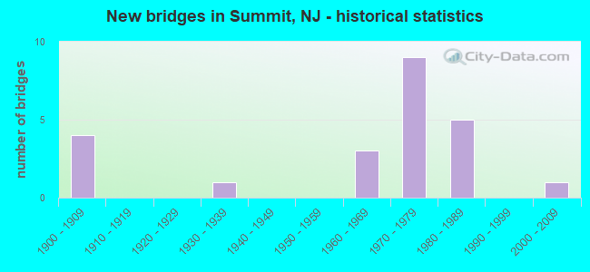
- New bridges - historical statistics
- 41900-1909
- 11930-1939
- 31960-1969
- 91970-1979
- 51980-1989
- 12000-2009
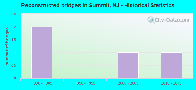
- Reconstructed bridges - Historical Statistics
- 21980-1989
- 01990-1999
- 12000-2009
- 12010-2019
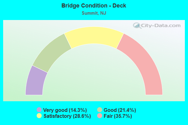
- Bridge Condition - Deck
- 14.3%Very good
- 21.4%Good
- 28.6%Satisfactory
- 35.7%Fair
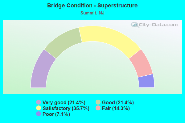
- Bridge Condition - Superstructure
- 21.4%Very good
- 21.4%Good
- 35.7%Satisfactory
- 14.3%Fair
- 7.1%Poor
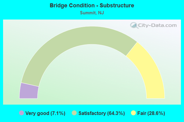
- Bridge Condition - Substructure
- 7.1%Very good
- 64.3%Satisfactory
- 28.6%Fair
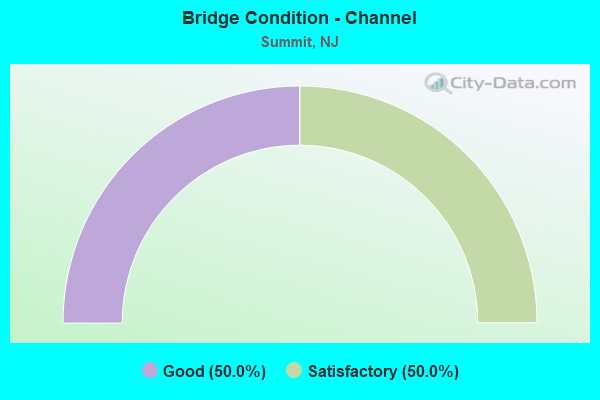
- Bridge Condition - Channel
- 50.0%Good
- 50.0%Satisfactory
Find on map >> Show street view
Structure Number: 73316, Location: 0.25 MI E OF PASSAIC RIVR (Lat: 40.738781, Lng: -74.369919), Route carried "on" structure: State highway 124, Year Built: 1971, Status: Open, Structure Length: 4.51m (14.80ft), Average Daily Traffic: 6,080 (year 2021), Truck Traffic: 4%, Average Future Daily Traffic: 7,419 (year 2041), Design Load: HS 20, Features Intersected: JFK PARKWAY
Minimum Vertical Clearance: 30+ m (98+ ft), Kilometerpoint: 11.974, Lanes on structure: 3, Lanes under structure: 5, Base Highway Network: Yes, Owner: State Highway Agency, Approaching Roadway Width: 18.3m (60.0ft), Skew: 30 degrees, Material/Design: Steel, Design/Construction: Stringer/Multi-beam, Number Of Spans In Main Unit: 2, Length of Maximum Span: 21.9m (71.9ft), Curb or Sidewalk Widths: Left: 0.8m (2.6ft), Right: 1.8m (5.9ft), Curb-To-Curb Width: 18.3m (60.0ft), Out-to-Out Width: 22.7m (74.5ft)
Condition: Deck: Satisfactory, Superstructure: Good, Substructure: Satisfactory, Operating Rating: 74.4 metric tons, Method Used To Determine Operating Rating: Load Factor (LF), Inventory Rating: 44.5 metric tons, Method Used To Determine Inventory Rating: Load Factor (LF), Structural Evaluation: Equal to present minimum criteria, Deck Geometry: Superior to present desirable criteria, Underclear: Somewhat better than minimum adequacy, Approach Roadway Alignment: Equal to present minimum criteria, Designated Inspection Frequency: Every 24 months, Inspection Date: May 2021, Deck Structure Type: Concrete Cast-file-Place, Wearing Surface/Protective System: Wearing Surface: Latex Concrete
Find on map >> Show street view
Structure Number: 733163, Location: 1 MI EAST OF PASSAIC RIVE (Lat: 40.733219, Lng: -74.354219), Route carried "on" structure: County highway 657, Year Built: 1973, Status: Open, Structure Length: 4.94m (16.21ft), Average Daily Traffic: 9,214 (year 2020), Truck Traffic: 4%, Average Future Daily Traffic: 11,057 (year 2040), Design Load: HS 20, Features Intersected: NJ 24
Minimum Vertical Clearance: 30+ m (98+ ft), Kilometerpoint: 2.124, Lanes on structure: 4, Lanes under structure: 6, Owner: State Highway Agency, Approaching Roadway Width: 13.4m (44.0ft), Material/Design: Steel, Design/Construction: Stringer/Multi-beam, Number Of Spans In Main Unit: 2, Length of Maximum Span: 23.8m (78.1ft), Curb or Sidewalk Widths: Left: 0.8m (2.6ft), Right: 1.8m (5.9ft), Curb-To-Curb Width: 13.4m (44.0ft), Out-to-Out Width: 16.6m (54.5ft)
Condition: Deck: Satisfactory, Superstructure: Satisfactory, Substructure: Fair, Operating Rating: 76.2 metric tons, Method Used To Determine Operating Rating: Load Factor (LF), Inventory Rating: 45.4 metric tons, Method Used To Determine Inventory Rating: Load Factor (LF), Structural Evaluation: Somewhat better than minimum adequacy, Deck Geometry: High priority of replacement, Underclear: Meets minimum limits, Approach Roadway Alignment: Equal to present desirable criteria, Length Of Structure Improvement: 4.94m (16.21ft), Designated Inspection Frequency: Every 24 months, Inspection Date: September 2020, Bridge Improvement Cost: $163,000, Roadway Improvement Cost: $28,000, Total Project Cost: $191,000 ( Estimate for 2020), Deck Structure Type: Concrete Cast-file-Place, Wearing Surface/Protective System: Wearing Surface: Monolithic Concrete
Find on map >> Show street view
Structure Number: 733165, Location: 1.78 MI.E.OF PASSAIC R. (Lat: 40.727361, Lng: -74.345561), Route carried "on" structure: County highway 608, Year Built: 1973, Status: Open, Structure Length: 5.55m (18.21ft), Average Daily Traffic: 6,350 (year 2020), Truck Traffic: 3%, Average Future Daily Traffic: 7,750 (year 2040), Design Load: HS 20+Mod, Features Intersected: NJ 24
Minimum Vertical Clearance: 30+ m (98+ ft), Kilometerpoint: 0.000, Lanes on structure: 4, Lanes under structure: 6, Owner: State Highway Agency, Approaching Roadway Width: 14.0m (45.9ft), Skew: 2 degrees, Material/Design: Steel, Design/Construction: Stringer/Multi-beam, Number Of Spans In Main Unit: 2, Length of Maximum Span: 26.5m (86.9ft), Curb or Sidewalk Widths: Left: 1.8m (5.9ft), Right: 0.8m (2.6ft), Curb-To-Curb Width: 14.0m (45.9ft), Out-to-Out Width: 17.2m (56.4ft)
Condition: Deck: Fair, Superstructure: Satisfactory, Substructure: Satisfactory, Operating Rating: 45.4 metric tons, Method Used To Determine Operating Rating: Load Factor (LF), Inventory Rating: 27.2 metric tons, Method Used To Determine Inventory Rating: Load Factor (LF), Structural Evaluation: Equal to present minimum criteria, Deck Geometry: High priority of replacement, Underclear: High priority of corrective action, Approach Roadway Alignment: Equal to present desirable criteria, Length Of Structure Improvement: 5.55m (18.21ft), Designated Inspection Frequency: Every 24 months, Inspection Date: August 2020, Bridge Improvement Cost: $1,369,000, Roadway Improvement Cost: $300,000, Total Project Cost: $2,076,000 ( Estimate for 2020), Deck Structure Type: Concrete Cast-file-Place, Wearing Surface/Protective System: Wearing Surface: Monolithic Concrete
Find on map >> Show street view
Structure Number: 733166, Location: 1.35 MI. WEST OF I-78 (Lat: 40.725081, Lng: -74.342889), Route carried "on" structure: State highway 24, Year Built: 1973, Status: Open, Structure Length: 2.56m (8.40ft), Average Daily Traffic: 64,042 (year 2021), Truck Traffic: 5%, Average Future Daily Traffic: 87,902 (year 2041), Design Load: HS 20, Features Intersected: NJ 124 EASTBOUND
Minimum Vertical Clearance: 30+ m (98+ ft), Kilometerpoint: 14.211, Lanes on structure: 4, Lanes under structure: 2, Base Highway Network: Yes, Owner: State Highway Agency, Approaching Roadway Width: 19.2m (63.0ft), Skew: 5 degrees, Material/Design: Steel, Design/Construction: Stringer/Multi-beam, Number Of Spans In Main Unit: 1, Length of Maximum Span: 25.3m (83.0ft), Curb or Sidewalk Widths: Left: 0.2m (0.7ft), Right: 0.5m (1.6ft), Curb-To-Curb Width: 19.2m (63.0ft), Out-to-Out Width: 20.3m (66.6ft)
Condition: Deck: Fair, Superstructure: Fair, Substructure: Satisfactory, Operating Rating: 73.5 metric tons, Method Used To Determine Operating Rating: Load Factor (LF), Inventory Rating: 43.5 metric tons, Method Used To Determine Inventory Rating: Load Factor (LF), Structural Evaluation: Somewhat better than minimum adequacy, Deck Geometry: Somewhat better than minimum adequacy, Underclear: Meets minimum limits, Approach Roadway Alignment: Equal to present desirable criteria, Designated Inspection Frequency: Every 24 months, Inspection Date: June 2021, Deck Structure Type: Concrete Cast-file-Place, Wearing Surface/Protective System: Wearing Surface: Monolithic Concrete
Find on map >> Show street view
Structure Number: 140052, Location: 1.8 MI SW NJ24&NJ124 JCT (Lat: 40.720311, Lng: -74.391111), Route carried "on" structure: City street , Year Built: 2006, Status: Open, Structure Length: 3.29m (10.79ft), Average Daily Traffic: 3,932 (year 2021), Truck Traffic: 3%, Average Future Daily Traffic: 4,798 (year 2041), Design Load: HS 25 or greater, Features Intersected: PASSAIC RIVER, Facility Carried by Structure: MOUNT VERNON AVE
Minimum Vertical Clearance: 30+ m (98+ ft), Kilometerpoint: 0.708, Lanes on structure: 2, Owner: County Highway Agency, Approaching Roadway Width: 9.1m (29.9ft), Material/Design: Prestressed concrete, Design/Construction: Stringer/Multi-beam, Number Of Spans In Main Unit: 1, Length of Maximum Span: 31.4m (103.0ft), Curb or Sidewalk Widths: Left: 1.5m (4.9ft), Right: 0.0m, Curb-To-Curb Width: 9.1m (29.9ft), Out-to-Out Width: 11.7m (38.4ft)
Condition: Deck: Good, Superstructure: Very good, Substructure: Very good, Channel: Satisfactory, Inventory Rating: 49.0 metric tons, Method Used To Determine Inventory Rating: Load Factor (LF), Structural Evaluation: Equal to present desirable criteria, Deck Geometry: Meets minimum limits, Waterway Adequacy: Superior to present desirable criteria, Approach Roadway Alignment: Equal to present desirable criteria, Designated Inspection Frequency: Every 24 months, Inspection Date: June 2021, Deck Structure Type: Concrete Cast-file-Place, Wearing Surface/Protective System: Wearing Surface: Monolithic Concrete, Deck Protection: Epoxy Coated Reinforcing
Find on map >> Show street view
Structure Number: 2010154, Location: 1.8 MI E OF I-78 EXIT 43 (Lat: 40.673119, Lng: -74.406639), Route carried "on" structure: Interstate 78, Year Built: 1986, Status: Open, Structure Length: 5.58m (18.31ft), Average Daily Traffic: 98,211 (year 2020), Truck Traffic: 9%, Average Future Daily Traffic: 119,836 (year 2040), Design Load: HS 20+Mod, Features Intersected: DIAMOND HILL RD (CO 655)
Minimum Vertical Clearance: 30+ m (98+ ft), Kilometerpoint: 70.827, Lanes on structure: 6, Lanes under structure: 4, Base Highway Network: Yes, Owner: State Highway Agency, Approaching Roadway Width: 36.4m (119.4ft), Skew: 23 degrees, Material/Design: Steel, Design/Construction: Stringer/Multi-beam, Number Of Spans In Main Unit: 3, Length of Maximum Span: 29.9m (98.1ft), Curb-To-Curb Width: 36.4m (119.4ft), Out-to-Out Width: 38.3m (125.7ft)
Condition: Deck: Good, Superstructure: Satisfactory, Substructure: Satisfactory, Inventory Rating: 54.4 metric tons, Method Used To Determine Inventory Rating: Load Factor (LF), Structural Evaluation: Equal to present minimum criteria, Deck Geometry: Superior to present desirable criteria, Underclear: Meets minimum limits, Approach Roadway Alignment: Equal to present desirable criteria, Designated Inspection Frequency: Every 24 months, Inspection Date: May 2020, Deck Structure Type: Concrete Cast-file-Place, Wearing Surface/Protective System: Wearing Surface: Bituminous, Deck Protection: Epoxy Coated Reinforcing
Find on map >> Show street view
Structure Number: 2010157, Location: 0.9 MI E OF I-78 EXIT 44 (Lat: 40.688831, Lng: -74.381081), Route carried "on" structure: Other road , Year Built: 1985, Status: Open, Structure Length: 4.02m (13.19ft), Design Load: HS 20+Mod, Features Intersected: ROUTE I-78, Facility Carried by Structure: NIKE SITE ROAD
Minimum Vertical Clearance: 30+ m (98+ ft), Kilometerpoint: 0.000, Lanes on structure: 2, Lanes under structure: 6, Owner: State Highway Agency, Approaching Roadway Width: 9.1m (29.9ft), Material/Design: Steel continuous, Design/Construction: Stringer/Multi-beam, Number Of Spans In Main Unit: 2, Length of Maximum Span: 19.5m (64.0ft), Curb or Sidewalk Widths: Left: 0.6m (2.0ft), Right: 0.6m (2.0ft), Curb-To-Curb Width: 9.1m (29.9ft), Out-to-Out Width: 40.2m (131.9ft)
Condition: Deck: Satisfactory, Superstructure: Satisfactory, Substructure: Satisfactory, Operating Rating: 62.6 metric tons, Method Used To Determine Operating Rating: Load Factor (LF), Inventory Rating: 37.2 metric tons, Method Used To Determine Inventory Rating: Load Factor (LF), Structural Evaluation: Equal to present minimum criteria, Deck Geometry: Better than present minimum criteria, Underclear: Equal to present minimum criteria, Approach Roadway Alignment: Better than present minimum criteria, Designated Inspection Frequency: Every 24 months, Inspection Date: May 2021, Deck Structure Type: Concrete Cast-file-Place, Wearing Surface/Protective System: Wearing Surface: Latex Concrete
Find on map >> Show street view
Structure Number: 2010158, Location: 2.6 MI E OF I-78 EXIT 43 (Lat: 40.697611, Lng: -74.366831), Route carried "on" structure: County highway 527, Year Built: 1985, Status: Open, Structure Length: 7.92m (25.98ft), Average Daily Traffic: 8,715 (year 2021), Truck Traffic: 4%, Average Future Daily Traffic: 10,458 (year 2041), Design Load: HS 20+Mod, Features Intersected: I-78
Minimum Vertical Clearance: 30+ m (98+ ft), Kilometerpoint: 75.189, Lanes on structure: 2, Lanes under structure: 6, Owner: State Highway Agency, Approaching Roadway Width: 12.2m (40.0ft), Skew: 5 degrees, Material/Design: Steel continuous, Design/Construction: Stringer/Multi-beam, Number Of Spans In Main Unit: 2, Length of Maximum Span: 38.7m (127.0ft), Curb-To-Curb Width: 12.2m (40.0ft), Out-to-Out Width: 28.6m (93.8ft)
Condition: Deck: Fair, Superstructure: Satisfactory, Substructure: Satisfactory, Operating Rating: 66.2 metric tons, Method Used To Determine Operating Rating: Load Factor (LF), Inventory Rating: 39.9 metric tons, Method Used To Determine Inventory Rating: Load Factor (LF), Structural Evaluation: Equal to present minimum criteria, Deck Geometry: Somewhat better than minimum adequacy, Underclear: Equal to present minimum criteria, Approach Roadway Alignment: Equal to present desirable criteria, Designated Inspection Frequency: Every 24 months, Critical Feature Inspection Frequency: Every 24 months, Inspection Date: May 2021, Critical Feature Inspection Date: May 2021, Deck Structure Type: Concrete Cast-file-Place, Wearing Surface/Protective System: Wearing Surface: Latex Concrete
Find on map >> Show street view
Structure Number: 2017009, Location: 0.24 MI SE OF CR 651 (Lat: 40.712261, Lng: -74.338239), Route carried "on" structure: County highway 636, Year Built: 1978, Status: Open, Structure Length: 0.61m (2.00ft), Average Daily Traffic: 6,763 (year 2020), Truck Traffic: 4%, Average Future Daily Traffic: 8,252 (year 2040), Design Load: HS 20, Features Intersected: STREAM 10-35
Minimum Vertical Clearance: 30+ m (98+ ft), Kilometerpoint: 0.386, Lanes on structure: 2, Owner: County Highway Agency, Approaching Roadway Width: 12.1m (39.7ft), Skew: 1 degrees, Material/Design: Concrete, Design/Construction: Culvert, Number Of Spans In Main Unit: 1, Length of Maximum Span: 6.1m (20.0ft), Curb-To-Curb Width: 12.1m (39.7ft), Out-to-Out Width: 15.2m (49.9ft)
Condition: Channel: Good, Culverts: Good, Operating Rating: 45.4 metric tons, Method Used To Determine Operating Rating: Load Factor (LF), Inventory Rating: 27.2 metric tons, Method Used To Determine Inventory Rating: Load Factor (LF), Structural Evaluation: Equal to present minimum criteria, Deck Geometry: Somewhat better than minimum adequacy, Waterway Adequacy: Equal to present desirable criteria, Approach Roadway Alignment: Better than present minimum criteria, Designated Inspection Frequency: Every 24 months, Inspection Date: May 2020, Wearing Surface/Protective System: Wearing Surface: Bituminous
Find on map >> Show street view
Structure Number: 2018151, Location: At Intch 9B of NJ 24 (Lat: 40.717611, Lng: -74.331731), Route carried "on" structure: County highway 527, Year Built: 1967, Status: Open, Structure Length: 9.11m (29.89ft), Average Daily Traffic: 9,405 (year 2021), Truck Traffic: 4%, Average Future Daily Traffic: 11,285 (year 2041), Design Load: HS 20, Features Intersected: NJ 24
Minimum Vertical Clearance: 30+ m (98+ ft), Kilometerpoint: 112.332, Lanes on structure: 3, Lanes under structure: 7, Owner: State Highway Agency, Approaching Roadway Width: 13.4m (44.0ft), Skew: 33 degrees, Material/Design: Steel, Design/Construction: Stringer/Multi-beam, Number Of Spans In Main Unit: 4, Length of Maximum Span: 33.5m (109.9ft), Curb or Sidewalk Widths: Left: 0.7m (2.3ft), Right: 1.8m (5.9ft), Curb-To-Curb Width: 13.3m (43.6ft), Out-to-Out Width: 18.0m (59.1ft)
Condition: Deck: Fair, Superstructure: Fair, Substructure: Fair, Operating Rating: 45.4 metric tons, Method Used To Determine Operating Rating: Load Factor (LF), Inventory Rating: 27.2 metric tons, Method Used To Determine Inventory Rating: Load Factor (LF), Structural Evaluation: Somewhat better than minimum adequacy, Deck Geometry: Somewhat better than minimum adequacy, Underclear: High priority of corrective action, Approach Roadway Alignment: Equal to present minimum criteria, Length Of Structure Improvement: 30.48m (100.00ft), Designated Inspection Frequency: Every 24 months, Inspection Date: July 2021, Roadway Improvement Cost: $510,000, Total Project Cost: $675,000 ( Estimate for 2021), Deck Structure Type: Concrete Cast-file-Place, Wearing Surface/Protective System: Wearing Surface: Monolithic Concrete
Find on map >> Show street view
Structure Number: 2062152, Location: East of Summit Station (Lat: 40.716050, Lng: -74.356319), Route carried "on" structure: County highway 657, Year Built: 1905, Year Reconstructed: 1992, Status: Open, Structure Length: 2.68m (8.79ft), Average Daily Traffic: 10,640 (year 2021), Truck Traffic: 4%, Average Future Daily Traffic: 12,980 (year 2041), Design Load: HS 20+Mod, Features Intersected: MorristownLine(MP 20.03)
Minimum Vertical Clearance: 30+ m (98+ ft), Kilometerpoint: 0.322, Lanes on structure: 2, Owner: State Agenciy, Approaching Roadway Width: 11.0m (36.1ft), Skew: 1 degrees, Material/Design: Steel, Design/Construction: Stringer/Multi-beam, Number Of Spans In Main Unit: 1, Length of Maximum Span: 25.3m (83.0ft), Curb or Sidewalk Widths: Left: 1.8m (5.9ft), Right: 1.8m (5.9ft), Curb-To-Curb Width: 11.0m (36.1ft), Out-to-Out Width: 15.4m (50.5ft)
Condition: Deck: Very good, Superstructure: Good, Substructure: Satisfactory, Inventory Rating: 67.1 metric tons, Method Used To Determine Inventory Rating: Load Factor (LF), Structural Evaluation: Equal to present minimum criteria, Deck Geometry: Meets minimum limits, Underclear: High priority of replacement, Approach Roadway Alignment: Equal to present minimum criteria, Length Of Structure Improvement: 2.68m (8.79ft), Designated Inspection Frequency: Every 24 months, Inspection Date: April 2021, Bridge Improvement Cost: $4,042,000, Roadway Improvement Cost: $1,011,000, Total Project Cost: $15,159,000 ( Estimate for 2021), Deck Structure Type: Concrete Cast-file-Place, Wearing Surface/Protective System: Wearing Surface: Monolithic Concrete, Deck Protection: Epoxy Coated Reinforcing
Find on map >> Show street view
Structure Number: 2062154, Location: 0.1 MI West of Summit Sta (Lat: 40.716769, Lng: -74.359061), Route carried "on" structure: City street , Year Built: 1903, Year Reconstructed: 1993, Status: Open, Structure Length: 1.62m (5.31ft), Average Daily Traffic: 11,357 (year 2021), Truck Traffic: 3%, Average Future Daily Traffic: 16,034 (year 2041), Design Load: HS 20+Mod, Features Intersected: MorristownLine(MP 20.18), Facility Carried by Structure: Maple Street
Minimum Vertical Clearance: 30+ m (98+ ft), Kilometerpoint: 0.708, Lanes on structure: 2, Owner: State Agenciy, Approaching Roadway Width: 9.1m (29.9ft), Material/Design: Prestressed concrete, Design/Construction: Slab, Number Of Spans In Main Unit: 1, Length of Maximum Span: 14.9m (48.9ft), Curb or Sidewalk Widths: Left: 2.0m (6.6ft), Right: 2.0m (6.6ft), Curb-To-Curb Width: 9.1m (29.9ft), Out-to-Out Width: 13.8m (45.3ft)
Condition: Deck: Satisfactory, Superstructure: Good, Substructure: Fair, Operating Rating: 88.0 metric tons, Method Used To Determine Operating Rating: Load Factor (LF), Inventory Rating: 52.6 metric tons, Method Used To Determine Inventory Rating: Load Factor (LF), Structural Evaluation: Somewhat better than minimum adequacy, Deck Geometry: High priority of corrective action, Underclear: High priority of replacement, Approach Roadway Alignment: Equal to present desirable criteria, Length Of Structure Improvement: 1.62m (5.31ft), Designated Inspection Frequency: Every 24 months, Inspection Date: April 2021, Bridge Improvement Cost: $1,931,000, Roadway Improvement Cost: $483,000, Total Project Cost: $7,241,000 ( Estimate for 2021), Deck Structure Type: Concrete Cast-file-Place, Wearing Surface/Protective System: Wearing Surface: Latex Concrete, Deck Protection: Epoxy Coated Reinforcing
Find on map >> Show street view
Structure Number: 2062155, Location: 0.11 MI East of CR651 (Lat: 40.717469, Lng: -74.362069), Route carried "on" structure: City street , Year Built: 1905, Year Reconstructed: 2008, Status: Open, Structure Length: 2.29m (7.51ft), Average Daily Traffic: 24,577 (year 2021), Truck Traffic: 3%, Average Future Daily Traffic: 29,989 (year 2041), Design Load: HL 93, Features Intersected: MORRISTOWN LINE MP 20.34, Facility Carried by Structure: SPRINGFIELD AVENUE
Minimum Vertical Clearance: 30+ m (98+ ft), Kilometerpoint: 1.979, Lanes on structure: 2, Owner: State Agenciy, Approaching Roadway Width: 9.1m (29.9ft), Skew: 4 degrees, Material/Design: Steel, Design/Construction: Stringer/Multi-beam, Number Of Spans In Main Unit: 1, Length of Maximum Span: 21.6m (70.9ft), Curb or Sidewalk Widths: Left: 1.8m (5.9ft), Right: 1.8m (5.9ft), Curb-To-Curb Width: 9.1m (29.9ft), Out-to-Out Width: 13.6m (44.6ft)
Condition: Deck: Good, Superstructure: Very good, Substructure: Satisfactory, Operating Rating: 54.1 metric tons, Method Used To Determine Operating Rating: Load and Resistance Factor Rating (LRFR) rating reported by rating factor(RF) method using HL-93 loadings, Inventory Rating: 41.8 metric tons, Method Used To Determine Inventory Rating: Load and Resistance Factor Rating (LRFR) rating reported by rating factor(RF) method using HL-93 loadings, Structural Evaluation: Equal to present minimum criteria, Deck Geometry: High priority of corrective action, Underclear: High priority of replacement, Approach Roadway Alignment: Equal to present desirable criteria, Length Of Structure Improvement: 2.29m (7.51ft), Designated Inspection Frequency: Every 24 months, Inspection Date: April 2021, Bridge Improvement Cost: $2,656,000, Roadway Improvement Cost: $664,000, Total Project Cost: $9,958,000 ( Estimate for 2021), Deck Structure Type: Concrete Cast-file-Place, Wearing Surface/Protective System: Deck Protection: Epoxy Coated Reinforcing
Find on map >> Show street view
Structure Number: 2062156, Location: 0.1 mi N of CR512 (Lat: 40.718200, Lng: -74.365050), Route carried "on" structure: County highway 651, Year Built: 1905, Year Reconstructed: 2018, Status: Open, Structure Length: 2.71m (8.89ft), Average Daily Traffic: 23,315 (year 2021), Truck Traffic: 4%, Average Future Daily Traffic: 28,450 (year 2041), Design Load: HL 93, Features Intersected: Morristown L (MP 20.51)
Minimum Vertical Clearance: 30+ m (98+ ft), Kilometerpoint: 0.161, Lanes on structure: 2, Owner: State Agenciy, Approaching Roadway Width: 9.1m (29.9ft), Skew: 5 degrees, Material/Design: Steel, Design/Construction: Stringer/Multi-beam, Number Of Spans In Main Unit: 1, Length of Maximum Span: 24.1m (79.1ft), Curb or Sidewalk Widths: Left: 0.0m, Right: 1.5m (4.9ft), Curb-To-Curb Width: 9.1m (29.9ft), Out-to-Out Width: 13.0m (42.7ft)
Condition: Deck: Very good, Superstructure: Very good, Substructure: Satisfactory, Operating Rating: 86.8 metric tons, Method Used To Determine Operating Rating: Load and Resistance Factor Rating (LRFR) rating reported by rating factor(RF) method using HL-93 loadings, Inventory Rating: 67.1 metric tons, Method Used To Determine Inventory Rating: Load and Resistance Factor Rating (LRFR) rating reported by rating factor(RF) method using HL-93 loadings, Structural Evaluation: Equal to present minimum criteria, Deck Geometry: High priority of corrective action, Underclear: High priority of replacement, Approach Roadway Alignment: Equal to present minimum criteria, Length Of Structure Improvement: 2.71m (8.89ft), Designated Inspection Frequency: Every 24 months, Inspection Date: April 2021, Bridge Improvement Cost: $2,742,000, Roadway Improvement Cost: $686,000, Total Project Cost: $10,284,000 ( Estimate for 2019), Deck Structure Type: Concrete Cast-file-Place, Wearing Surface/Protective System: Wearing Surface: Monolithic Concrete, Deck Protection: Galvanized Reinforcing
Find on map >> Show street view
Structure Number: 2062157, Location: South of Kent Pl Blvd. (Lat: 40.718300, Lng: -74.370961), Route carried "on" structure: City street , Year Built: 1937, Status: Open, Structure Length: 2.04m (6.69ft), Average Daily Traffic: 9,348 (year 2021), Truck Traffic: 3%, Average Future Daily Traffic: 11,216 (year 2041), Design Load: H 20, Features Intersected: MORRISTOWN LINE, Facility Carried by Structure: HIGH STREET
Minimum Vertical Clearance: 30+ m (98+ ft), Kilometerpoint: 0.386, Lanes on structure: 2, Owner: State Agenciy, Approaching Roadway Width: 9.1m (29.9ft), Skew: 2 degrees, Material/Design: Steel, Design/Construction: Frame, Number Of Spans In Main Unit: 1, Length of Maximum Span: 18.0m (59.1ft), Curb or Sidewalk Widths: Left: 1.5m (4.9ft), Right: 1.7m (5.6ft), Curb-To-Curb Width: 9.1m (29.9ft), Out-to-Out Width: 12.9m (42.3ft)
Condition: Deck: Fair, Superstructure: Poor, Substructure: Fair, Operating Rating: 87.1 metric tons, Method Used To Determine Operating Rating: Load Factor (LF), Inventory Rating: 51.7 metric tons, Method Used To Determine Inventory Rating: Load Factor (LF), Structural Evaluation: Meets minimum limits, Deck Geometry: High priority of corrective action, Underclear: High priority of replacement, Approach Roadway Alignment: Somewhat better than minimum adequacy, Length Of Structure Improvement: 2.71m (8.89ft), Designated Inspection Frequency: Every 24 months, Inspection Date: April 2021, Bridge Improvement Cost: $3,996,000, Roadway Improvement Cost: $999,000, Total Project Cost: $14,987,000 ( Estimate for 2021), Deck Structure Type: Concrete Cast-file-Place, Wearing Surface/Protective System: Wearing Surface: Bituminous
Find on map >> Show street view
Structure Number: 73316, Location: 0.25 MI E OF PASSAIC RIVR (Lat: 40.738781, Lng: -74.369919), Route carried "under" structure: County highway 649, Year Built: 1971, Structure Length: 0. m, Average Daily Traffic: 15,838 (year 2021), Truck Traffic: 4%, Features Intersected: JFK PARKWAY, Facility Carried by Structure: NJ124EB&NJ24 RAMPD
Minimum Vertical Clearance: 5.03m (16.50ft), Kilometerpoint: 0.048, Lanes on structure: 3, Lanes under structure: 5, Material/Design: Steel, Design/Construction: Stringer/Multi-beam, Length of Maximum Span: 21.9m (71.9ft)
Find on map >> Show street view
Structure Number: 733163, Location: 1 MI EAST OF PASSAIC RIVE (Lat: 40.733219, Lng: -74.354219), Route carried "under" structure: State highway 24, Year Built: 1973, Structure Length: 0. m, Average Daily Traffic: 107,468 (year 2020), Truck Traffic: 5%, Features Intersected: NJ 24, Facility Carried by Structure: SUMMIT AVE(CO.657)
Minimum Vertical Clearance: 4.93m (16.17ft), Kilometerpoint: 12.859, Lanes on structure: 4, Lanes under structure: 6, Material/Design: Steel, Design/Construction: Stringer/Multi-beam, Length of Maximum Span: 23.8m (78.1ft)
Find on map >> Show street view
Structure Number: 733165, Location: 1.78 MI.E.OF PASSAIC R. (Lat: 40.727361, Lng: -74.345561), Route carried "under" structure: State highway 24, Year Built: 1973, Structure Length: 0. m, Average Daily Traffic: 114,230 (year 2020), Truck Traffic: 5%, Features Intersected: NJ 24, Facility Carried by Structure: CR 608 HOBART GAP
Minimum Vertical Clearance: 4.57m (14.99ft), Kilometerpoint: 13.840, Lanes on structure: 4, Lanes under structure: 6, Material/Design: Steel, Design/Construction: Stringer/Multi-beam, Length of Maximum Span: 26.5m (86.9ft)
Find on map >> Show street view
Structure Number: 733166, Location: 1.35 MI. WEST OF I-78 (Lat: 40.725081, Lng: -74.342889), Route carried "under" structure: State highway 124, Year Built: 1973, Structure Length: 0. m, Average Daily Traffic: 7,169 (year 2021), Truck Traffic: 4%, Features Intersected: NJ 124 EASTBOUND, Facility Carried by Structure: NJ 24 EASTBOUND
Minimum Vertical Clearance: 5.05m (16.57ft), Kilometerpoint: 14.790, Lanes on structure: 4, Lanes under structure: 2, Material/Design: Steel, Design/Construction: Stringer/Multi-beam, Length of Maximum Span: 25.3m (83.0ft)
Find on map >> Show street view
Structure Number: 2010157, Location: 0.9 MI E OF I-78 EXIT 44 (Lat: 40.688831, Lng: -74.381081), Route carried "under" structure: Interstate 78, Year Built: 1985, Structure Length: 0. m, Average Daily Traffic: 99,363 (year 2021), Truck Traffic: 9%, Features Intersected: ROUTE I-78, Facility Carried by Structure: NIKE SITE ROAD
Minimum Vertical Clearance: 6.55m (21.49ft), Kilometerpoint: 73.611, Lanes on structure: 2, Lanes under structure: 6, Material/Design: Steel continuous, Design/Construction: Stringer/Multi-beam, Length of Maximum Span: 19.5m (64.0ft)
Find on map >> Show street view
Structure Number: 2010158, Location: 2.6 MI E OF I-78 EXIT 43 (Lat: 40.697611, Lng: -74.366831), Route carried "under" structure: Interstate 78, Year Built: 1985, Structure Length: 0. m, Average Daily Traffic: 105,470 (year 2021), Truck Traffic: 9%, Features Intersected: I-78, Facility Carried by Structure: GLENSIDE AVE (527)
Minimum Vertical Clearance: 5.21m (17.09ft), Kilometerpoint: 75.189, Lanes on structure: 2, Lanes under structure: 6, Material/Design: Steel continuous, Design/Construction: Stringer/Multi-beam, Length of Maximum Span: 38.7m (127.0ft)
Find on map >> Show street view
Structure Number: 201815, Location: At Intch 9A of NJ 24 (Lat: 40.719211, Lng: -74.333600), Route carried "under" structure: State highway 24, Year Built: 1967, Structure Length: 0. m, Average Daily Traffic: 125,204 (year 2021), Truck Traffic: 5%, Features Intersected: NJ 24, Facility Carried by Structure: Broad St CR512 SB
Minimum Vertical Clearance: 5.08m (16.67ft), Kilometerpoint: 15.208, Lanes on structure: 2, Lanes under structure: 7, Material/Design: Steel, Design/Construction: Stringer/Multi-beam, Length of Maximum Span: 25.3m (83.0ft)
Find on map >> Show street view
Structure Number: 2018151, Location: At Intch 9B of NJ 24 (Lat: 40.717611, Lng: -74.331731), Route carried "under" structure: State highway 24, Year Built: 1967, Structure Length: 0. m, Average Daily Traffic: 122,080 (year 2021), Truck Traffic: 5%, Features Intersected: NJ 24, Facility Carried by Structure: MORRIS AVE (CR527)
Minimum Vertical Clearance: 4.78m (15.68ft), Kilometerpoint: 15.450, Lanes on structure: 3, Lanes under structure: 7, Material/Design: Steel, Design/Construction: Stringer/Multi-beam, Length of Maximum Span: 33.5m (109.9ft)