Bridge Statistics for Summit, Illinois (IL)
Condition, Traffic, Stress, Structural Evaluation, Project Costs
- National Bridge Inventory (NBI) Statistics
- 40Number of bridges
- 1,204ft / 367mTotal length
- $34,655,000Total costs
- 1,500,387Total average daily traffic
- 163,858Total average daily truck traffic
- National Bridge Inventory (NBI) Registered Bridges for Summit
- No street view available for this location
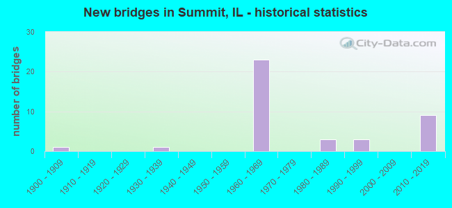
- New bridges - historical statistics
- 11900-1909
- 11930-1939
- 231960-1969
- 31980-1989
- 31990-1999
- 92010-2019

- Reconstructed bridges - Historical Statistics
- 11980-1989
- 41990-1999
- 52000-2009
- 102010-2019


- Bridge Condition - Deck
- 26.9%Very good
- 53.8%Good
- 15.4%Satisfactory
- 3.8%Fair

- Bridge Condition - Superstructure
- 11.5%Very good
- 7.7%Good
- 19.2%Satisfactory
- 46.2%Fair
- 3.8%Poor
- 7.7%Serious
- 3.8%Critical

- Bridge Condition - Substructure
- 11.5%Very good
- 42.3%Good
- 23.1%Satisfactory
- 23.1%Fair

- Bridge Condition - Channel
- 55.6%Very good
- 22.2%Good
- 11.1%Satisfactory
- 11.1%Fair
Find on map >> Show street view
Structure Number: 160012, Location: 2.2 M SW ILL 43 (Lat: 41.783794, Lng: -87.830481), Route carried "on" structure: Interstate 55, Year Built: 1963, Year Reconstructed: 2000, Status: Open, Structure Length: 6.83m (22.41ft), Average Daily Traffic: 69,300 (year 2021), Truck Traffic: 10%, Average Future Daily Traffic: 83,945 (year 2032), Features Intersected: RR - CSXT
Minimum Vertical Clearance: 30+ m (98+ ft), Kilometerpoint: 453.308, Lanes on structure: 3, Base Highway Network: Yes, Owner: State Highway Agency, Approaching Roadway Width: 18.3m (60.0ft), Material/Design: Steel continuous, Design/Construction: Stringer/Multi-beam, Number Of Spans In Main Unit: 4, Length of Maximum Span: 18.3m (60.0ft), Curb-To-Curb Width: 20.4m (66.9ft), Out-to-Out Width: 21.3m (69.9ft)
Condition: Deck: Good, Superstructure: Fair, Substructure: Fair, Operating Rating: 89.1 metric tons, Method Used To Determine Operating Rating: Load Factor (LF) rating reported by rating factor (RF) method using MS18 loading, Inventory Rating: 56.1 metric tons, Method Used To Determine Inventory Rating: Load Factor (LF) rating reported by rating factor (RF) method using MS18 loading, Structural Evaluation: Somewhat better than minimum adequacy, Deck Geometry: Superior to present desirable criteria, Underclear: Somewhat better than minimum adequacy, Approach Roadway Alignment: Equal to present desirable criteria, Designated Inspection Frequency: Every 24 months, Inspection Date: July 2020, Deck Structure Type: Concrete Cast-file-Place, Wearing Surface/Protective System: Deck Protection: Epoxy Coated Reinforcing
Find on map >> Show street view
Structure Number: 160013, Location: 2.2 M SW ILL 43 (Lat: 41.783900, Lng: -87.830347), Route carried "on" structure: Interstate 55, Year Built: 1963, Year Reconstructed: 2000, Status: Open, Structure Length: 6.83m (22.41ft), Average Daily Traffic: 69,300 (year 2021), Truck Traffic: 10%, Average Future Daily Traffic: 83,945 (year 2032), Features Intersected: RR - CSXT
Minimum Vertical Clearance: 30+ m (98+ ft), Kilometerpoint: 453.324, Lanes on structure: 3, Base Highway Network: Yes, Owner: State Highway Agency, Approaching Roadway Width: 18.3m (60.0ft), Material/Design: Steel continuous, Design/Construction: Stringer/Multi-beam, Number Of Spans In Main Unit: 4, Length of Maximum Span: 18.3m (60.0ft), Curb-To-Curb Width: 20.3m (66.6ft), Out-to-Out Width: 21.3m (69.9ft)
Condition: Deck: Good, Superstructure: Fair, Substructure: Fair, Operating Rating: 89.1 metric tons, Method Used To Determine Operating Rating: Load Factor (LF) rating reported by rating factor (RF) method using MS18 loading, Inventory Rating: 56.1 metric tons, Method Used To Determine Inventory Rating: Load Factor (LF) rating reported by rating factor (RF) method using MS18 loading, Structural Evaluation: Somewhat better than minimum adequacy, Deck Geometry: Superior to present desirable criteria, Underclear: Somewhat better than minimum adequacy, Approach Roadway Alignment: Equal to present desirable criteria, Designated Inspection Frequency: Every 24 months, Inspection Date: July 2020, Deck Structure Type: Concrete Cast-file-Place, Wearing Surface/Protective System: Deck Protection: Epoxy Coated Reinforcing
Find on map >> Show street view
Structure Number: 160014, Location: 0.9 M SW ILL 43 (Lat: 41.796436, Lng: -87.813294), Route carried "on" structure: Interstate 55, Year Built: 1964, Year Reconstructed: 2000, Status: Open, Structure Length: 21.31m (69.91ft), Average Daily Traffic: 66,150 (year 2021), Truck Traffic: 10%, Average Future Daily Traffic: 84,409 (year 2032), Features Intersected: SAN & SHIP CANAL
Minimum Vertical Clearance: 30+ m (98+ ft), Kilometerpoint: 455.255, Lanes on structure: 4, Lanes under structure: 2, Base Highway Network: Yes, Owner: State Highway Agency, Approaching Roadway Width: 21.3m (69.9ft), Skew: 4 degrees, Navigation Control: Yes ( Vertical Clearance: 11.3m (37.1ft), Horizontal Clearance: 48.8m (160.1ft)), Material/Design: Steel continuous, Design/Construction: Stringer/Multi-beam, Number Of Spans In Main Unit: 5, Length of Maximum Span: 73.3m (240.5ft), Curb-To-Curb Width: 21.9m (71.9ft), Out-to-Out Width: 22.9m (75.1ft)
Condition: Deck: Good, Superstructure: Fair, Substructure: Satisfactory, Channel: Very good, Operating Rating: 65.4 metric tons, Method Used To Determine Operating Rating: Load Factor (LF) rating reported by rating factor (RF) method using MS18 loading, Inventory Rating: 39.2 metric tons, Method Used To Determine Inventory Rating: Load Factor (LF) rating reported by rating factor (RF) method using MS18 loading, Structural Evaluation: Somewhat better than minimum adequacy, Deck Geometry: Better than present minimum criteria, Underclear: Meets minimum limits, Waterway Adequacy: Superior to present desirable criteria, Approach Roadway Alignment: Equal to present desirable criteria, Length Of Structure Improvement: 21.40m (70.21ft), Designated Inspection Frequency: Every 24 months, Underwater Inspection Frequency: Every 60 months, Other Special Inspection Frequency: Every 24 months, Inspection Date: May 2021, Underwater Inspection Date: July 2020, Other Special Inspection Date: May 2021, Bridge Improvement Cost: $3,256,000, Roadway Improvement Cost: $326,000, Total Project Cost: $5,373,000, Deck Structure Type: Concrete Cast-file-Place, Wearing Surface/Protective System: Deck Protection: Epoxy Coated Reinforcing
Find on map >> Show street view
Structure Number: 160015, Location: 0.9 M SW ILL 43 (Lat: 41.796425, Lng: -87.812939), Route carried "on" structure: Interstate 55, Year Built: 1964, Year Reconstructed: 2000, Status: Open, Structure Length: 21.31m (69.91ft), Average Daily Traffic: 66,150 (year 2021), Truck Traffic: 10%, Average Future Daily Traffic: 84,409 (year 2032), Features Intersected: SAN & SHIP CANAL
Minimum Vertical Clearance: 30+ m (98+ ft), Kilometerpoint: 455.287, Lanes on structure: 4, Lanes under structure: 2, Base Highway Network: Yes, Owner: State Highway Agency, Approaching Roadway Width: 21.9m (71.9ft), Skew: 4 degrees, Navigation Control: Yes ( Vertical Clearance: 11.6m (38.1ft), Horizontal Clearance: 49.1m (161.1ft)), Material/Design: Steel continuous, Design/Construction: Stringer/Multi-beam, Number Of Spans In Main Unit: 5, Length of Maximum Span: 73.3m (240.5ft), Curb-To-Curb Width: 21.9m (71.9ft), Out-to-Out Width: 22.9m (75.1ft)
Condition: Deck: Good, Superstructure: Fair, Substructure: Satisfactory, Channel: Very good, Operating Rating: 65.1 metric tons, Method Used To Determine Operating Rating: Load Factor (LF) rating reported by rating factor (RF) method using MS18 loading, Inventory Rating: 38.9 metric tons, Method Used To Determine Inventory Rating: Load Factor (LF) rating reported by rating factor (RF) method using MS18 loading, Structural Evaluation: Somewhat better than minimum adequacy, Deck Geometry: Better than present minimum criteria, Underclear: Somewhat better than minimum adequacy, Waterway Adequacy: Superior to present desirable criteria, Approach Roadway Alignment: Equal to present desirable criteria, Length Of Structure Improvement: 21.40m (70.21ft), Designated Inspection Frequency: Every 24 months, Underwater Inspection Frequency: Every 60 months, Other Special Inspection Frequency: Every 24 months, Inspection Date: May 2021, Underwater Inspection Date: July 2020, Other Special Inspection Date: May 2021, Bridge Improvement Cost: $3,256,000, Roadway Improvement Cost: $326,000, Total Project Cost: $5,373,000, Deck Structure Type: Concrete Cast-file-Place, Wearing Surface/Protective System: Deck Protection: Epoxy Coated Reinforcing
Find on map >> Show street view
Structure Number: 160316, Location: 0.47 MI N OF ARCHER (Lat: 41.799508, Lng: -87.802125), Route carried "on" structure: State highway 43, Year Built: 1964, Year Reconstructed: 1990, Status: Temporarily open, Structure Length: 7.65m (25.10ft), Average Daily Traffic: 35,800 (year 2021), Truck Traffic: 4%, Average Future Daily Traffic: 45,114 (year 2032), Design Load: HS 20, Features Intersected: I- 55 STEVENSON
Minimum Vertical Clearance: 30+ m (98+ ft), Kilometerpoint: 32.942, Lanes on structure: 9, Lanes under structure: 6, Base Highway Network: Yes, Owner: State Highway Agency, Approaching Roadway Width: 13.4m (44.0ft), Skew: 22 degrees, Material/Design: Steel continuous, Design/Construction: Stringer/Multi-beam, Number Of Spans In Main Unit: 4, Length of Maximum Span: 25.6m (84.0ft), Curb or Sidewalk Widths: Left: 1.5m (4.9ft), Right: 1.5m (4.9ft), Curb-To-Curb Width: 39.6m (129.9ft), Out-to-Out Width: 45.7m (149.9ft)
Condition: Deck: Fair, Superstructure: Critical, Substructure: Fair, Structural Evaluation: High priority of replacement, Deck Geometry: Superior to present desirable criteria, Underclear: High priority of corrective action, Approach Roadway Alignment: Equal to present desirable criteria, Designated Inspection Frequency: Every 12 months, Other Special Inspection Frequency: Every 6 months, Inspection Date: October 2021, Other Special Inspection Date: October 2021, Deck Structure Type: Concrete Cast-file-Place, Wearing Surface/Protective System: Wearing Surface: Other, Deck Protection: Epoxy Coated Reinforcing
Find on map >> Show street view
Structure Number: 160317, Location: 0.1 M S I-55 (Lat: 41.797967, Lng: -87.802078), Route carried "on" structure: State highway 43, Year Built: 1966, Year Reconstructed: 1990, Status: Open, Structure Length: 21.77m (71.42ft), Average Daily Traffic: 42,700 (year 2019), Truck Traffic: 10%, Average Future Daily Traffic: 22,557 (year 2032), Design Load: HS 20, Features Intersected: RR - CN
Minimum Vertical Clearance: 30+ m (98+ ft), Kilometerpoint: 32.765, Lanes on structure: 3, Base Highway Network: Yes, Owner: State Highway Agency, Approaching Roadway Width: 13.4m (44.0ft), Skew: 2 degrees, Material/Design: Steel continuous, Design/Construction: Stringer/Multi-beam, Number Of Spans In Main Unit: 11, Length of Maximum Span: 22.4m (73.5ft), Curb or Sidewalk Widths: Left: 0.0m, Right: 1.5m (4.9ft), Curb-To-Curb Width: 13.0m (42.7ft), Out-to-Out Width: 15.3m (50.2ft)
Condition: Deck: Good, Superstructure: Fair, Substructure: Fair, Operating Rating: 71.3 metric tons, Method Used To Determine Operating Rating: Load Factor (LF) rating reported by rating factor (RF) method using MS18 loading, Inventory Rating: 42.4 metric tons, Method Used To Determine Inventory Rating: Load Factor (LF) rating reported by rating factor (RF) method using MS18 loading, Structural Evaluation: Somewhat better than minimum adequacy, Deck Geometry: Meets minimum limits, Underclear: Equal to present minimum criteria, Approach Roadway Alignment: Better than present minimum criteria, Designated Inspection Frequency: Every 24 months, Inspection Date: June 2021, Deck Structure Type: Concrete Cast-file-Place, Wearing Surface/Protective System: Deck Protection: Epoxy Coated Reinforcing
Find on map >> Show street view
Structure Number: 160318, Location: 0.1 M S I-55 (Lat: 41.798142, Lng: -87.802083), Route carried "on" structure: State highway 43, Year Built: 1931, Year Reconstructed: 1990, Status: Open, Structure Length: 6.64m (21.78ft), Average Daily Traffic: 42,700 (year 2019), Truck Traffic: 10%, Average Future Daily Traffic: 22,557 (year 2032), Design Load: HS 20, Features Intersected: RR - CN
Minimum Vertical Clearance: 30+ m (98+ ft), Kilometerpoint: 32.781, Lanes on structure: 4, Base Highway Network: Yes, Owner: State Highway Agency, Approaching Roadway Width: 13.4m (44.0ft), Skew: 2 degrees, Material/Design: Steel continuous, Design/Construction: Stringer/Multi-beam, Number Of Spans In Main Unit: 4, Length of Maximum Span: 21.3m (69.9ft), Curb or Sidewalk Widths: Left: 0.0m, Right: 1.5m (4.9ft), Curb-To-Curb Width: 14.8m (48.6ft), Out-to-Out Width: 16.9m (55.4ft)
Condition: Deck: Satisfactory, Superstructure: Satisfactory, Substructure: Satisfactory, Operating Rating: 88.1 metric tons, Method Used To Determine Operating Rating: Load Factor (LF) rating reported by rating factor (RF) method using MS18 loading, Inventory Rating: 53.1 metric tons, Method Used To Determine Inventory Rating: Load Factor (LF) rating reported by rating factor (RF) method using MS18 loading, Structural Evaluation: Equal to present minimum criteria, Deck Geometry: High priority of replacement, Underclear: Somewhat better than minimum adequacy, Approach Roadway Alignment: Equal to present desirable criteria, Length Of Structure Improvement: 7.99m (26.21ft), Designated Inspection Frequency: Every 24 months, Inspection Date: June 2021, Bridge Improvement Cost: $1,857,000, Roadway Improvement Cost: $186,000, Total Project Cost: $2,786,000, Deck Structure Type: Concrete Cast-file-Place, Wearing Surface/Protective System: Deck Protection: Epoxy Coated Reinforcing
Find on map >> Show street view
Structure Number: 160483, Location: 0.2 M W I-55 (Lat: 41.794708, Lng: -87.824428), Route carried "on" structure: State highway 171, Year Built: 1964, Year Reconstructed: 2015, Status: Open, Structure Length: 16.09m (52.79ft), Average Daily Traffic: 38,500 (year 2021), Truck Traffic: 11%, Average Future Daily Traffic: 18,695 (year 2032), Design Load: HS 20, Features Intersected: DES PLAINES RIVER
Minimum Vertical Clearance: 30+ m (98+ ft), Kilometerpoint: 40.361, Lanes on structure: 2, Base Highway Network: Yes, Owner: State Highway Agency, Approaching Roadway Width: 16.8m (55.1ft), Material/Design: Steel continuous, Design/Construction: Stringer/Multi-beam, Number Of Spans In Main Unit: 4, Length of Maximum Span: 44.5m (146.0ft), Curb-To-Curb Width: 13.5m (44.3ft), Out-to-Out Width: 14.5m (47.6ft)
Condition: Deck: Good, Superstructure: Fair, Substructure: Good, Channel: Good, Operating Rating: 76.8 metric tons, Method Used To Determine Operating Rating: Load Factor (LF) rating reported by rating factor (RF) method using MS18 loading, Inventory Rating: 46.0 metric tons, Method Used To Determine Inventory Rating: Load Factor (LF) rating reported by rating factor (RF) method using MS18 loading, Structural Evaluation: Somewhat better than minimum adequacy, Deck Geometry: Superior to present desirable criteria, Waterway Adequacy: Equal to present desirable criteria, Approach Roadway Alignment: Equal to present desirable criteria, Designated Inspection Frequency: Every 24 months, Underwater Inspection Frequency: Every 48 months, Inspection Date: Febuary 2021, Underwater Inspection Date: December 2021, Deck Structure Type: Concrete Cast-file-Place, Wearing Surface/Protective System: Deck Protection: Epoxy Coated Reinforcing
Find on map >> Show street view
Structure Number: 160486, Location: 0.2 M SE I-55 (Lat: 41.792739, Lng: -87.819119), Route carried "on" structure: State highway 171, Year Built: 1963, Year Reconstructed: 2015, Status: Open, Structure Length: 25.40m (83.33ft), Average Daily Traffic: 47,700 (year 2021), Truck Traffic: 16%, Average Future Daily Traffic: 28,119 (year 2032), Design Load: HS 20, Features Intersected: S&S CANAL
Minimum Vertical Clearance: 30+ m (98+ ft), Kilometerpoint: 39.927, Lanes on structure: 2, Lanes under structure: 1, Base Highway Network: Yes, Owner: State Highway Agency, Approaching Roadway Width: 10.4m (34.1ft), Skew: 1 degrees, Navigation Control: Yes ( Vertical Clearance: 12.2m (40.0ft), Horizontal Clearance: 48.8m (160.1ft)), Material/Design: Steel continuous, Design/Construction: Stringer/Multi-beam, Number Of Spans In Main Unit: 14, Length of Maximum Span: 52.9m (173.6ft), Curb-To-Curb Width: 9.1m (29.9ft), Out-to-Out Width: 11.0m (36.1ft)
Condition: Deck: Good, Superstructure: Serious, Substructure: Fair, Channel: Very good, Operating Rating: 52.2 metric tons, Method Used To Determine Operating Rating: Load Factor (LF) rating reported by rating factor (RF) method using MS18 loading, Inventory Rating: 31.1 metric tons, Method Used To Determine Inventory Rating: Load Factor (LF) rating reported by rating factor (RF) method using MS18 loading, Structural Evaluation: High priority of corrective action, Deck Geometry: Meets minimum limits, Underclear: High priority of corrective action, Waterway Adequacy: Superior to present desirable criteria, Approach Roadway Alignment: Equal to present desirable criteria, Length Of Structure Improvement: 25.12m (82.41ft), Designated Inspection Frequency: Every 12 months, Underwater Inspection Frequency: Every 60 months, Inspection Date: April 2021, Underwater Inspection Date: July 2020, Bridge Improvement Cost: $2,855,000, Roadway Improvement Cost: $286,000, Total Project Cost: $4,283,000, Deck Structure Type: Concrete Cast-file-Place, Wearing Surface/Protective System: Deck Protection: Epoxy Coated Reinforcing
Find on map >> Show street view
Structure Number: 160487, Location: 0.2 M SE I-55 (Lat: 41.792622, Lng: -87.818836), Route carried "on" structure: State highway 171, Year Built: 1963, Year Reconstructed: 2016, Status: Open, Structure Length: 24.22m (79.46ft), Average Daily Traffic: 47,700 (year 2021), Truck Traffic: 16%, Average Future Daily Traffic: 28,119 (year 2032), Design Load: HS 20, Features Intersected: S&S CANAL
Minimum Vertical Clearance: 30+ m (98+ ft), Kilometerpoint: 39.911, Lanes on structure: 2, Lanes under structure: 1, Base Highway Network: Yes, Owner: State Highway Agency, Approaching Roadway Width: 12.2m (40.0ft), Skew: 2 degrees, Navigation Control: Yes ( Vertical Clearance: 8.8m (28.9ft), Horizontal Clearance: 48.8m (160.1ft)), Material/Design: Steel continuous, Design/Construction: Stringer/Multi-beam, Number Of Spans In Main Unit: 11, Length of Maximum Span: 52.9m (173.6ft), Curb-To-Curb Width: 12.2m (40.0ft), Out-to-Out Width: 13.2m (43.3ft)
Condition: Deck: Good, Superstructure: Serious, Substructure: Fair, Channel: Very good, Operating Rating: 56.7 metric tons, Method Used To Determine Operating Rating: Load Factor (LF) rating reported by rating factor (RF) method using MS18 loading, Inventory Rating: 34.0 metric tons, Method Used To Determine Inventory Rating: Load Factor (LF) rating reported by rating factor (RF) method using MS18 loading, Structural Evaluation: High priority of corrective action, Deck Geometry: Better than present minimum criteria, Underclear: High priority of replacement, Waterway Adequacy: Superior to present desirable criteria, Approach Roadway Alignment: Equal to present desirable criteria, Length Of Structure Improvement: 25.63m (84.09ft), Designated Inspection Frequency: Every 12 months, Underwater Inspection Frequency: Every 60 months, Inspection Date: April 2021, Underwater Inspection Date: July 2020, Bridge Improvement Cost: $3,436,000, Roadway Improvement Cost: $344,000, Total Project Cost: $5,154,000, Deck Structure Type: Concrete Cast-file-Place, Wearing Surface/Protective System: Deck Protection: Epoxy Coated Reinforcing
Find on map >> Show street view
Structure Number: 160488, Location: 0.3 M SE I-55 (Lat: 41.791492, Lng: -87.815822), Route carried "on" structure: State highway 171, Year Built: 1963, Year Reconstructed: 2015, Status: Open, Structure Length: 5.07m (16.63ft), Average Daily Traffic: 47,700 (year 2021), Truck Traffic: 16%, Average Future Daily Traffic: 28,119 (year 2032), Design Load: HS 20, Features Intersected: RR - CN
Minimum Vertical Clearance: 30+ m (98+ ft), Kilometerpoint: 39.541, Lanes on structure: 3, Base Highway Network: Yes, Owner: State Highway Agency, Approaching Roadway Width: 16.8m (55.1ft), Skew: 1 degrees, Material/Design: Steel continuous, Design/Construction: Stringer/Multi-beam, Number Of Spans In Main Unit: 3, Length of Maximum Span: 19.2m (63.0ft), Curb-To-Curb Width: 15.8m (51.8ft), Out-to-Out Width: 16.8m (55.1ft)
Condition: Deck: Very good, Superstructure: Satisfactory, Substructure: Good, Operating Rating: 90.7 metric tons, Method Used To Determine Operating Rating: Load Factor (LF) rating reported by rating factor (RF) method using MS18 loading, Inventory Rating: 52.2 metric tons, Method Used To Determine Inventory Rating: Load Factor (LF) rating reported by rating factor (RF) method using MS18 loading, Structural Evaluation: Equal to present minimum criteria, Deck Geometry: Better than present minimum criteria, Underclear: Better than present minimum criteria, Approach Roadway Alignment: Equal to present desirable criteria, Designated Inspection Frequency: Every 24 months, Inspection Date: December 2021, Deck Structure Type: Concrete Cast-file-Place, Wearing Surface/Protective System: Deck Protection: Epoxy Coated Reinforcing
Find on map >> Show street view
Structure Number: 160489, Location: 0.3 M SE I-55 (Lat: 41.791450, Lng: -87.815692), Route carried "on" structure: State highway 171, Year Built: 1963, Year Reconstructed: 2016, Status: Open, Structure Length: 5.07m (16.63ft), Average Daily Traffic: 47,700 (year 2021), Truck Traffic: 16%, Average Future Daily Traffic: 28,119 (year 2032), Design Load: HS 20, Features Intersected: RR - CN
Minimum Vertical Clearance: 30+ m (98+ ft), Kilometerpoint: 39.524, Lanes on structure: 3, Base Highway Network: Yes, Owner: State Highway Agency, Approaching Roadway Width: 16.2m (53.1ft), Skew: 1 degrees, Material/Design: Steel continuous, Design/Construction: Stringer/Multi-beam, Number Of Spans In Main Unit: 3, Length of Maximum Span: 18.8m (61.7ft), Curb-To-Curb Width: 16.2m (53.1ft), Out-to-Out Width: 17.1m (56.1ft)
Condition: Deck: Very good, Superstructure: Fair, Substructure: Good, Operating Rating: 91.4 metric tons, Method Used To Determine Operating Rating: Load Factor (LF) rating reported by rating factor (RF) method using MS18 loading, Inventory Rating: 53.8 metric tons, Method Used To Determine Inventory Rating: Load Factor (LF) rating reported by rating factor (RF) method using MS18 loading, Structural Evaluation: Somewhat better than minimum adequacy, Deck Geometry: Better than present minimum criteria, Underclear: Better than present minimum criteria, Approach Roadway Alignment: Equal to present desirable criteria, Designated Inspection Frequency: Every 24 months, Inspection Date: December 2021, Deck Structure Type: Concrete Cast-file-Place, Wearing Surface/Protective System: Deck Protection: Epoxy Coated Reinforcing
Find on map >> Show street view
Structure Number: 160985, Location: 0.2 M NW I-55 (Lat: 41.794792, Lng: -87.824644), Route carried "on" structure: State highway 171, Year Built: 1964, Year Reconstructed: 2016, Status: Open, Structure Length: 16.09m (52.79ft), Average Daily Traffic: 38,500 (year 2021), Truck Traffic: 11%, Average Future Daily Traffic: 18,695 (year 2032), Design Load: HS 20, Features Intersected: DES PLAINES RIVER
Minimum Vertical Clearance: 30+ m (98+ ft), Kilometerpoint: 40.377, Lanes on structure: 2, Base Highway Network: Yes, Owner: State Highway Agency, Approaching Roadway Width: 17.7m (58.1ft), Material/Design: Steel continuous, Design/Construction: Stringer/Multi-beam, Number Of Spans In Main Unit: 4, Length of Maximum Span: 44.5m (146.0ft), Curb-To-Curb Width: 12.2m (40.0ft), Out-to-Out Width: 13.2m (43.3ft)
Condition: Deck: Very good, Superstructure: Fair, Substructure: Good, Channel: Good, Operating Rating: 75.5 metric tons, Method Used To Determine Operating Rating: Load Factor (LF) rating reported by rating factor (RF) method using MS18 loading, Inventory Rating: 45.4 metric tons, Method Used To Determine Inventory Rating: Load Factor (LF) rating reported by rating factor (RF) method using MS18 loading, Structural Evaluation: Somewhat better than minimum adequacy, Deck Geometry: Better than present minimum criteria, Waterway Adequacy: Equal to present desirable criteria, Approach Roadway Alignment: Equal to present desirable criteria, Designated Inspection Frequency: Every 24 months, Underwater Inspection Frequency: Every 48 months, Inspection Date: Febuary 2021, Underwater Inspection Date: March 2021, Deck Structure Type: Concrete Cast-file-Place, Wearing Surface/Protective System: Deck Protection: Epoxy Coated Reinforcing
Find on map >> Show street view
Structure Number: 160987, Location: 1.3 M SW IL 43 (Lat: 41.795653, Lng: -87.822581), Route carried "on" structure: Other road , Year Built: 1963, Year Reconstructed: 1994, Status: Open, Structure Length: 26.61m (87.30ft), Average Daily Traffic: 4,500 (year 2021), Average Future Daily Traffic: 11,536 (year 2032), Design Load: HS 20, Features Intersected: DES PLAINES RIVER, Facility Carried by Structure: I- 55 WB RMP IL171
Minimum Vertical Clearance: 30+ m (98+ ft), Kilometerpoint: 0.402, Lanes on structure: 1, Base Highway Network: Yes (Inventory Route: 10055R40, Subroute: 60), Owner: State Highway Agency, Approaching Roadway Width: 7.9m (25.9ft), Skew: 6 degrees, Material/Design: Steel continuous, Design/Construction: Stringer/Multi-beam, Number Of Spans In Main Unit: 8, Length of Maximum Span: 33.8m (110.9ft), Curb-To-Curb Width: 7.9m (25.9ft), Out-to-Out Width: 8.9m (29.2ft)
Condition: Deck: Satisfactory, Superstructure: Fair, Substructure: Satisfactory, Channel: Fair, Operating Rating: 70.0 metric tons, Method Used To Determine Operating Rating: Load Factor (LF) rating reported by rating factor (RF) method using MS18 loading, Inventory Rating: 41.8 metric tons, Method Used To Determine Inventory Rating: Load Factor (LF) rating reported by rating factor (RF) method using MS18 loading, Structural Evaluation: Somewhat better than minimum adequacy, Deck Geometry: High priority of corrective action, Waterway Adequacy: Equal to present desirable criteria, Approach Roadway Alignment: Equal to present desirable criteria, Length Of Structure Improvement: 27.19m (89.21ft), Designated Inspection Frequency: Every 24 months, Underwater Inspection Frequency: Every 48 months, Inspection Date: November 2020, Underwater Inspection Date: September 2018, Bridge Improvement Cost: $1,734,000, Roadway Improvement Cost: $173,000, Total Project Cost: $2,601,000, Deck Structure Type: Concrete Cast-file-Place, Wearing Surface/Protective System: Deck Protection: Epoxy Coated Reinforcing
Find on map >> Show street view
Structure Number: 161026, Location: 1.5 M SW IL 43 (Lat: 41.793844, Lng: -87.824797), Route carried "on" structure: Other road , Year Built: 1964, Year Reconstructed: 2014, Status: Open, Structure Length: 20.96m (68.77ft), Average Daily Traffic: 10,000 (year 2021), Average Future Daily Traffic: 13,699 (year 2032), Design Load: HS 20, Features Intersected: DES PLAINES RIVER, Facility Carried by Structure: IL 171 SB RMP I-55
Minimum Vertical Clearance: 30+ m (98+ ft), Kilometerpoint: 0.370, Lanes on structure: 1, Base Highway Network: Yes (Inventory Route: 10055040, Subroute: 30), Owner: State Highway Agency, Approaching Roadway Width: 7.9m (25.9ft), Skew: 3 degrees, Material/Design: Steel continuous, Design/Construction: Stringer/Multi-beam, Number Of Spans In Main Unit: 7, Length of Maximum Span: 31.1m (102.0ft), Curb-To-Curb Width: 7.9m (25.9ft), Out-to-Out Width: 8.9m (29.2ft)
Condition: Deck: Satisfactory, Superstructure: Poor, Substructure: Good, Channel: Satisfactory, Operating Rating: 79.7 metric tons, Method Used To Determine Operating Rating: Load Factor (LF) rating reported by rating factor (RF) method using MS18 loading, Inventory Rating: 45.0 metric tons, Method Used To Determine Inventory Rating: Load Factor (LF) rating reported by rating factor (RF) method using MS18 loading, Structural Evaluation: Meets minimum limits, Deck Geometry: High priority of corrective action, Waterway Adequacy: Equal to present desirable criteria, Approach Roadway Alignment: Better than present minimum criteria, Length Of Structure Improvement: 21.24m (69.69ft), Designated Inspection Frequency: Every 12 months, Underwater Inspection Frequency: Every 48 months, Inspection Date: May 2021, Underwater Inspection Date: August 2018, Bridge Improvement Cost: $1,611,000, Roadway Improvement Cost: $161,000, Total Project Cost: $2,417,000, Deck Structure Type: Concrete Cast-file-Place, Wearing Surface/Protective System: Deck Protection: Epoxy Coated Reinforcing
Find on map >> Show street view
Structure Number: 16151, Location: 1.4M SW of Il43 (Lat: 41.793372, Lng: -87.820814), Route carried "on" structure: State highway 171, Year Built: 2015, Status: Open, Structure Length: 7.89m (25.89ft), Average Daily Traffic: 47,700 (year 2021), Truck Traffic: 16%, Average Future Daily Traffic: 28,119 (year 2032), Design Load: HS 25 or greater, Features Intersected: I- 55 STEVENSON
Minimum Vertical Clearance: 30+ m (98+ ft), Kilometerpoint: 40.039, Lanes on structure: 3, Lanes under structure: 7, Base Highway Network: Yes, Owner: State Highway Agency, Approaching Roadway Width: 16.6m (54.5ft), Skew: 1 degrees, Material/Design: Steel continuous, Design/Construction: Stringer/Multi-beam, Number Of Spans In Main Unit: 3, Length of Maximum Span: 28.1m (92.2ft), Curb-To-Curb Width: 16.6m (54.5ft), Out-to-Out Width: 18.2m (59.7ft)
Condition: Deck: Good, Superstructure: Very good, Substructure: Very good, Operating Rating: 64.2 metric tons, Method Used To Determine Operating Rating: Load and Resistance Factor Rating (LRFR) rating reported by rating factor(RF) method using HL-93 loadings, Inventory Rating: 49.6 metric tons, Method Used To Determine Inventory Rating: Load and Resistance Factor Rating (LRFR) rating reported by rating factor(RF) method using HL-93 loadings, Structural Evaluation: Equal to present desirable criteria, Deck Geometry: Equal to present desirable criteria, Underclear: High priority of corrective action, Approach Roadway Alignment: Equal to present desirable criteria, Designated Inspection Frequency: Every 24 months, Inspection Date: November 2021, Deck Structure Type: Concrete Cast-file-Place, Wearing Surface/Protective System: Deck Protection: Epoxy Coated Reinforcing
Find on map >> Show street view
Structure Number: 161511, Location: 1.4 M SW of IL 43 (Lat: 41.793333, Lng: -87.820714), Route carried "on" structure: State highway 171, Year Built: 2016, Status: Open, Structure Length: 7.89m (25.89ft), Average Daily Traffic: 47,700 (year 2021), Truck Traffic: 16%, Average Future Daily Traffic: 20,000 (year 2032), Design Load: HS 25 or greater, Features Intersected: I- 55 STEVENSON
Minimum Vertical Clearance: 30+ m (98+ ft), Kilometerpoint: 40.023, Lanes on structure: 3, Lanes under structure: 7, Base Highway Network: Yes, Owner: State Highway Agency, Approaching Roadway Width: 14.9m (48.9ft), Material/Design: Steel continuous, Design/Construction: Stringer/Multi-beam, Number Of Spans In Main Unit: 3, Length of Maximum Span: 28.1m (92.2ft), Curb-To-Curb Width: 14.9m (48.9ft), Out-to-Out Width: 15.9m (52.2ft)
Condition: Deck: Good, Superstructure: Very good, Substructure: Very good, Operating Rating: 71.6 metric tons, Method Used To Determine Operating Rating: Load and Resistance Factor Rating (LRFR) rating reported by rating factor(RF) method using HL-93 loadings, Inventory Rating: 55.1 metric tons, Method Used To Determine Inventory Rating: Load and Resistance Factor Rating (LRFR) rating reported by rating factor(RF) method using HL-93 loadings, Structural Evaluation: Equal to present desirable criteria, Deck Geometry: Equal to present minimum criteria, Underclear: Meets minimum limits, Approach Roadway Alignment: Equal to present desirable criteria, Designated Inspection Frequency: Every 24 months, Inspection Date: November 2021, Deck Structure Type: Concrete Cast-file-Place, Wearing Surface/Protective System: Deck Protection: Epoxy Coated Reinforcing
Find on map >> Show street view
Structure Number: 161512, Location: 1.4M SW of IL43 (Lat: 41.792178, Lng: -87.822108), Route carried "on" structure: Other road , Year Built: 2015, Status: Open, Structure Length: 8.63m (28.31ft), Average Daily Traffic: 10,000 (year 2021), Average Future Daily Traffic: 9,588 (year 2032), Design Load: HS 25 or greater, Features Intersected: I- 55 STEVENSON, Facility Carried by Structure: IL 171 SB RMP I-55
Minimum Vertical Clearance: 30+ m (98+ ft), Kilometerpoint: 0.724, Lanes on structure: 1, Lanes under structure: 7, Base Highway Network: Yes (Inventory Route: 10055040, Subroute: 30), Owner: State Highway Agency, Approaching Roadway Width: 9.8m (32.2ft), Skew: 3 degrees, Material/Design: Steel continuous, Design/Construction: Stringer/Multi-beam, Number Of Spans In Main Unit: 3, Length of Maximum Span: 35.3m (115.8ft), Curb-To-Curb Width: 9.8m (32.2ft), Out-to-Out Width: 10.7m (35.1ft)
Condition: Deck: Very good, Superstructure: Very good, Substructure: Very good, Operating Rating: 60.3 metric tons, Method Used To Determine Operating Rating: Load and Resistance Factor Rating (LRFR) rating reported by rating factor(RF) method using HL-93 loadings, Inventory Rating: 47.3 metric tons, Method Used To Determine Inventory Rating: Load and Resistance Factor Rating (LRFR) rating reported by rating factor(RF) method using HL-93 loadings, Structural Evaluation: Equal to present desirable criteria, Deck Geometry: Meets minimum limits, Underclear: Meets minimum limits, Approach Roadway Alignment: Equal to present minimum criteria, Designated Inspection Frequency: Every 24 months, Inspection Date: November 2021, Deck Structure Type: Concrete Cast-file-Place, Wearing Surface/Protective System: Deck Protection: Epoxy Coated Reinforcing
Find on map >> Show street view
Structure Number: 162021, Location: 0.5 M W IL 43 (Lat: 41.796522, Lng: -87.808156), Route carried "on" structure: Interstate 55, Year Built: 1964, Status: Open, Structure Length: 0.71m (2.33ft), Average Daily Traffic: 66,150 (year 2021), Truck Traffic: 10%, Average Future Daily Traffic: 84,409 (year 2032), Features Intersected: RR - CN SPUR
Minimum Vertical Clearance: 30+ m (98+ ft), Kilometerpoint: 455.722, Lanes on structure: 4, Base Highway Network: Yes, Owner: State Highway Agency, Approaching Roadway Width: 40.2m (131.9ft), Skew: 10 degrees, Material/Design: Concrete, Design/Construction: Culvert, Number Of Spans In Main Unit: 1, Length of Maximum Span: 6.8m (22.3ft), Curb-To-Curb Width: 34.1m (111.9ft), Out-to-Out Width: 34.7m (113.8ft)
Condition: Culverts: Satisfactory, Operating Rating: 53.8 metric tons, Method Used To Determine Operating Rating: Field evaluation and documented engineering judgment, Inventory Rating: 32.4 metric tons, Method Used To Determine Inventory Rating: Field evaluation and documented engineering judgment, Structural Evaluation: Equal to present minimum criteria, Deck Geometry: Superior to present desirable criteria, Underclear: Meets minimum limits, Approach Roadway Alignment: Equal to present desirable criteria, Designated Inspection Frequency: Every 24 months, Inspection Date: September 2020, Deck Structure Type: Other
Find on map >> Show street view
Structure Number: 162408, Location: 1 M N ARCHER AVE (Lat: 41.791867, Lng: -87.815772), Route carried "on" structure: Other road , Year Built: 1981, Year Reconstructed: 2001, Status: Open, Structure Length: 19.36m (63.52ft), Average Daily Traffic: 4,650 (year 2017), Average Future Daily Traffic: 2,275 (year 2032), Design Load: HS 20, Features Intersected: SAN & SHIP CANAL, Facility Carried by Structure: IL 171 NB TO I-55
Minimum Vertical Clearance: 30+ m (98+ ft), Kilometerpoint: 0.097, Lanes on structure: 1, Base Highway Network: Yes (Inventory Route: 10055R40, Subroute: 50), Owner: State Highway Agency, Approaching Roadway Width: 6.7m (22.0ft), Skew: 2 degrees, Navigation Control: Yes ( Vertical Clearance: 12.2m (40.0ft), Horizontal Clearance: 48.8m (160.1ft)), Material/Design: Steel continuous, Design/Construction: Stringer/Multi-beam, Number Of Spans In Main Unit: 5, Length of Maximum Span: 57.4m (188.3ft), Curb-To-Curb Width: 7.6m (24.9ft), Out-to-Out Width: 8.5m (27.9ft)
Condition: Deck: Satisfactory, Superstructure: Fair, Substructure: Good, Channel: Very good, Operating Rating: 82.6 metric tons, Method Used To Determine Operating Rating: Load Factor (LF) rating reported by rating factor (RF) method using MS18 loading, Inventory Rating: 49.2 metric tons, Method Used To Determine Inventory Rating: Load Factor (LF) rating reported by rating factor (RF) method using MS18 loading, Structural Evaluation: Somewhat better than minimum adequacy, Deck Geometry: High priority of replacement, Waterway Adequacy: Superior to present desirable criteria, Approach Roadway Alignment: Equal to present minimum criteria, Designated Inspection Frequency: Every 24 months, Underwater Inspection Frequency: Every 60 months, Inspection Date: November 2020, Underwater Inspection Date: July 2020, Deck Structure Type: Concrete Cast-file-Place, Wearing Surface/Protective System: Wearing Surface: Latex Concrete, Membrane: Built-up
Find on map >> Show street view
Structure Number: 162454, Location: 1.0 M W OF I-55 (Lat: 41.796156, Lng: -87.828336), Route carried "on" structure: State highway 171, Year Built: 1964, Year Reconstructed: 2015, Status: Open, Structure Length: 11.03m (36.19ft), Average Daily Traffic: 38,500 (year 2021), Truck Traffic: 11%, Average Future Daily Traffic: 18,695 (year 2032), Design Load: HS 20, Features Intersected: RR - BNSF
Minimum Vertical Clearance: 30+ m (98+ ft), Kilometerpoint: 40.747, Lanes on structure: 3, Base Highway Network: Yes, Owner: State Highway Agency, Approaching Roadway Width: 16.5m (54.1ft), Material/Design: Steel continuous, Design/Construction: Stringer/Multi-beam, Number Of Spans In Main Unit: 4, Length of Maximum Span: 33.2m (108.9ft), Curb-To-Curb Width: 14.7m (48.2ft), Out-to-Out Width: 15.7m (51.5ft)
Condition: Deck: Very good, Superstructure: Fair, Substructure: Good, Operating Rating: 58.3 metric tons, Method Used To Determine Operating Rating: Load Factor (LF) rating reported by rating factor (RF) method using MS18 loading, Inventory Rating: 35.0 metric tons, Method Used To Determine Inventory Rating: Load Factor (LF) rating reported by rating factor (RF) method using MS18 loading, Structural Evaluation: Somewhat better than minimum adequacy, Deck Geometry: Somewhat better than minimum adequacy, Underclear: Superior to present desirable criteria, Approach Roadway Alignment: Equal to present desirable criteria, Designated Inspection Frequency: Every 24 months, Inspection Date: December 2021, Deck Structure Type: Concrete Cast-file-Place, Wearing Surface/Protective System: Deck Protection: Epoxy Coated Reinforcing
Find on map >> Show street view
Structure Number: 162455, Location: 1.0 M W OF I-55 (Lat: 41.796225, Lng: -87.828528), Route carried "on" structure: State highway 171, Year Built: 1964, Year Reconstructed: 2015, Status: Open, Structure Length: 11.52m (37.80ft), Average Daily Traffic: 38,500 (year 2021), Truck Traffic: 11%, Average Future Daily Traffic: 18,695 (year 2032), Design Load: HS 20, Features Intersected: RR - BNSF
Minimum Vertical Clearance: 30+ m (98+ ft), Kilometerpoint: 40.764, Lanes on structure: 3, Base Highway Network: Yes, Owner: State Highway Agency, Approaching Roadway Width: 16.5m (54.1ft), Material/Design: Steel continuous, Design/Construction: Stringer/Multi-beam, Number Of Spans In Main Unit: 4, Length of Maximum Span: 36.6m (120.1ft), Curb-To-Curb Width: 13.4m (44.0ft), Out-to-Out Width: 15.2m (49.9ft)
Condition: Deck: Very good, Superstructure: Satisfactory, Substructure: Good, Operating Rating: 59.9 metric tons, Method Used To Determine Operating Rating: Load Factor (LF) rating reported by rating factor (RF) method using MS18 loading, Inventory Rating: 36.0 metric tons, Method Used To Determine Inventory Rating: Load Factor (LF) rating reported by rating factor (RF) method using MS18 loading, Structural Evaluation: Equal to present minimum criteria, Deck Geometry: Somewhat better than minimum adequacy, Underclear: Superior to present desirable criteria, Approach Roadway Alignment: Equal to present desirable criteria, Designated Inspection Frequency: Every 24 months, Inspection Date: December 2021, Deck Structure Type: Concrete Cast-file-Place, Wearing Surface/Protective System: Deck Protection: Epoxy Coated Reinforcing
Find on map >> Show street view
Structure Number: 162456, Location: 0.5 M SE JOLIET RD (Lat: 41.795547, Lng: -87.826678), Route carried "on" structure: State highway 171, Year Built: 1964, Year Reconstructed: 2016, Status: Open, Structure Length: 29.44m (96.59ft), Average Daily Traffic: 38,500 (year 2021), Truck Traffic: 11%, Average Future Daily Traffic: 18,695 (year 2032), Design Load: HS 20, Features Intersected: STA 53&15 TO 63&18
Minimum Vertical Clearance: 30+ m (98+ ft), Kilometerpoint: 40.538, Lanes on structure: 2, Base Highway Network: Yes, Owner: State Highway Agency, Approaching Roadway Width: 9.1m (29.9ft), Material/Design: Steel continuous, Design/Construction: Stringer/Multi-beam, Number Of Spans In Main Unit: 12, Length of Maximum Span: 40.4m (132.5ft), Curb-To-Curb Width: 9.1m (29.9ft), Out-to-Out Width: 11.0m (36.1ft)
Condition: Deck: Very good, Superstructure: Fair, Substructure: Good, Operating Rating: 65.8 metric tons, Method Used To Determine Operating Rating: Load Factor (LF) rating reported by rating factor (RF) method using MS18 loading, Inventory Rating: 37.9 metric tons, Method Used To Determine Inventory Rating: Load Factor (LF) rating reported by rating factor (RF) method using MS18 loading, Structural Evaluation: Somewhat better than minimum adequacy, Deck Geometry: Meets minimum limits, Approach Roadway Alignment: Equal to present desirable criteria, Length Of Structure Improvement: 31.73m (104.10ft), Designated Inspection Frequency: Every 24 months, Inspection Date: December 2021, Bridge Improvement Cost: $4,445,000, Roadway Improvement Cost: $445,000, Total Project Cost: $6,668,000, Deck Structure Type: Concrete Cast-file-Place, Wearing Surface/Protective System: Deck Protection: Epoxy Coated Reinforcing
Find on map >> Show street view
Structure Number: 162457, Location: 0.5 M SE JOLIET RD (Lat: 41.795897, Lng: -87.827631), Route carried "on" structure: State highway 171, Year Built: 1964, Year Reconstructed: 2015, Status: Open, Structure Length: 29.67m (97.34ft), Average Daily Traffic: 38,500 (year 2021), Truck Traffic: 11%, Average Future Daily Traffic: 18,695 (year 2032), Design Load: HS 20, Features Intersected: STA 53&15 TO 63&18
Minimum Vertical Clearance: 30+ m (98+ ft), Kilometerpoint: 40.699, Lanes on structure: 3, Base Highway Network: Yes, Owner: State Highway Agency, Approaching Roadway Width: 16.5m (54.1ft), Material/Design: Steel continuous, Design/Construction: Stringer/Multi-beam, Number Of Spans In Main Unit: 12, Length of Maximum Span: 32.4m (106.3ft), Curb-To-Curb Width: 16.4m (53.8ft), Out-to-Out Width: 18.1m (59.4ft)
Condition: Deck: Good, Superstructure: Satisfactory, Substructure: Good, Operating Rating: 66.4 metric tons, Method Used To Determine Operating Rating: Load Factor (LF) rating reported by rating factor (RF) method using MS18 loading, Inventory Rating: 39.9 metric tons, Method Used To Determine Inventory Rating: Load Factor (LF) rating reported by rating factor (RF) method using MS18 loading, Structural Evaluation: Equal to present minimum criteria, Deck Geometry: Better than present minimum criteria, Approach Roadway Alignment: Equal to present desirable criteria, Designated Inspection Frequency: Every 24 months, Inspection Date: December 2021, Deck Structure Type: Concrete Cast-file-Place, Wearing Surface/Protective System: Deck Protection: Epoxy Coated Reinforcing
Find on map >> Show street view
Structure Number: 162542, Location: 0.1 M S OF 63RD ST (Lat: 41.776403, Lng: -87.814536), Route carried "on" structure: City street , Year Built: 1991, Status: Open, Structure Length: 2.30m (7.55ft), Average Daily Traffic: 500 (year 2018), Truck Traffic: 9%, Average Future Daily Traffic: 1,133 (year 2032), Design Load: HS 20, Features Intersected: IL 171 (ARCHER AVE), Facility Carried by Structure: SERVICE RD NE
Minimum Vertical Clearance: 30+ m (98+ ft), Kilometerpoint: 0.064, Lanes on structure: 2, Lanes under structure: 4, Owner: State Highway Agency, Approaching Roadway Width: 9.1m (29.9ft), Skew: 1 degrees, Material/Design: Steel, Design/Construction: Stringer/Multi-beam, Number Of Spans In Main Unit: 1, Length of Maximum Span: 22.1m (72.5ft), Curb or Sidewalk Widths: Left: 1.5m (4.9ft), Right: 0.0m, Curb-To-Curb Width: 9.1m (29.9ft), Out-to-Out Width: 11.5m (37.7ft)
Condition: Deck: Good, Superstructure: Satisfactory, Substructure: Satisfactory, Operating Rating: 89.1 metric tons, Method Used To Determine Operating Rating: Load Factor (LF) rating reported by rating factor (RF) method using MS18 loading, Inventory Rating: 60.3 metric tons, Method Used To Determine Inventory Rating: Load Factor (LF) rating reported by rating factor (RF) method using MS18 loading, Structural Evaluation: Equal to present minimum criteria, Deck Geometry: Equal to present minimum criteria, Underclear: High priority of corrective action, Approach Roadway Alignment: Equal to present desirable criteria, Designated Inspection Frequency: Every 24 months, Inspection Date: June 2021, Deck Structure Type: Concrete Cast-file-Place, Wearing Surface/Protective System: Deck Protection: Epoxy Coated Reinforcing
Find on map >> Show street view
Structure Number: 162543, Location: 0.05 M S OF 63RD ST (Lat: 41.775819, Lng: -87.814472), Route carried "on" structure: Other road , Year Built: 1987, Status: Open, Structure Length: 2.26m (7.41ft), Average Daily Traffic: 512 (year 2018), Truck Traffic: 34%, Average Future Daily Traffic: 1,020 (year 2032), Features Intersected: IL 171 (ARCHER AVE), Facility Carried by Structure: SERVICE RD SW
Minimum Vertical Clearance: 30+ m (98+ ft), Kilometerpoint: 0.048, Lanes on structure: 1, Lanes under structure: 4, Owner: State Highway Agency, Approaching Roadway Width: 12.8m (42.0ft), Material/Design: Steel, Design/Construction: Stringer/Multi-beam, Number Of Spans In Main Unit: 1, Length of Maximum Span: 21.3m (69.9ft), Curb or Sidewalk Widths: Left: 1.5m (4.9ft), Right: 0.0m, Curb-To-Curb Width: 9.1m (29.9ft), Out-to-Out Width: 11.4m (37.4ft)
Condition: Deck: Good, Superstructure: Good, Substructure: Satisfactory, Operating Rating: 89.1 metric tons, Method Used To Determine Operating Rating: Load Factor (LF) rating reported by rating factor (RF) method using MS18 loading, Inventory Rating: 60.3 metric tons, Method Used To Determine Inventory Rating: Load Factor (LF) rating reported by rating factor (RF) method using MS18 loading, Structural Evaluation: Equal to present minimum criteria, Deck Geometry: Equal to present minimum criteria, Underclear: High priority of corrective action, Approach Roadway Alignment: High priority of corrective action, Designated Inspection Frequency: Every 24 months, Inspection Date: September 2020, Deck Structure Type: Concrete Cast-file-Place, Wearing Surface/Protective System: Deck Protection: Epoxy Coated Reinforcing
Find on map >> Show street view
Structure Number: 162607, Location: AT 60TH PL (Lat: 41.783794, Lng: -87.811728), Route carried "on" structure: State highway 171, Year Built: 1995, Status: Open, Structure Length: 4.07m (13.35ft), Average Daily Traffic: 26,700 (year 2021), Truck Traffic: 11%, Average Future Daily Traffic: 27,604 (year 2032), Design Load: HS 20, Features Intersected: RR - IHB
Minimum Vertical Clearance: 30+ m (98+ ft), Kilometerpoint: 38.205, Lanes on structure: 4, Base Highway Network: Yes, Owner: State Highway Agency, Approaching Roadway Width: 14.3m (46.9ft), Material/Design: Steel continuous, Design/Construction: Stringer/Multi-beam, Number Of Spans In Main Unit: 3, Length of Maximum Span: 14.6m (47.9ft), Curb or Sidewalk Widths: Left: 1.5m (4.9ft), Right: 1.5m (4.9ft), Curb-To-Curb Width: 15.5m (50.9ft), Out-to-Out Width: 19.2m (63.0ft)
Condition: Deck: Good, Superstructure: Good, Substructure: Good, Operating Rating: 76.5 metric tons, Method Used To Determine Operating Rating: Load Factor (LF) rating reported by rating factor (RF) method using MS18 loading, Inventory Rating: 46.0 metric tons, Method Used To Determine Inventory Rating: Load Factor (LF) rating reported by rating factor (RF) method using MS18 loading, Structural Evaluation: Better than present minimum criteria, Deck Geometry: Meets minimum limits, Underclear: High priority of corrective action, Approach Roadway Alignment: Better than present minimum criteria, Designated Inspection Frequency: Every 24 months, Inspection Date: October 2021, Deck Structure Type: Concrete Cast-file-Place, Wearing Surface/Protective System: Deck Protection: Epoxy Coated Reinforcing
Find on map >> Show street view
Structure Number: 160014, Location: 0.9 M SW ILL 43 (Lat: 41.796658, Lng: -87.816581), Route carried "under" structure: City street , Year Built: 1964, Structure Length: 0. m, Average Daily Traffic: 200 (year 1998), Features Intersected: SAN & SHIP CANAL, Facility Carried by Structure: I- 55 EB STEVENSON
Minimum Vertical Clearance: 6.93m (22.74ft), Kilometerpoint: 0.370, Lanes on structure: 4, Lanes under structure: 2, Material/Design: Steel continuous, Design/Construction: Stringer/Multi-beam, Length of Maximum Span: 73.3m (240.5ft)
Find on map >> Show street view
Structure Number: 160015, Location: 0.9 M SW ILL 43 (Lat: 41.796706, Lng: -87.816397), Route carried "under" structure: City street , Year Built: 1964, Structure Length: 0. m, Average Daily Traffic: 200 (year 1998), Features Intersected: SAN & SHIP CANAL, Facility Carried by Structure: I- 55 WB STEVENSON
Minimum Vertical Clearance: 6.91m (22.67ft), Kilometerpoint: 0.386, Lanes on structure: 4, Lanes under structure: 2, Material/Design: Steel continuous, Design/Construction: Stringer/Multi-beam, Length of Maximum Span: 73.3m (240.5ft)
Find on map >> Show street view
Structure Number: 160486, Location: 0.2 M SE I-55 (Lat: 41.792842, Lng: -87.818850), Route carried "under" structure: Other road , Year Built: 1963, Structure Length: 0. m, Average Daily Traffic: 10,000 (year 2021), Features Intersected: S&S CANAL, Facility Carried by Structure: IL 171 SB FIRST AV
Minimum Vertical Clearance: 4.93m (16.17ft), Kilometerpoint: 1.352, Lanes on structure: 2, Lanes under structure: 1, Material/Design: Steel continuous, Design/Construction: Stringer/Multi-beam, Length of Maximum Span: 52.9m (173.6ft)
Find on map >> Show street view
Structure Number: 160487, Location: 0.2 M SE I-55 (Lat: 41.793061, Lng: -87.818433), Route carried "under" structure: Other road , Year Built: 1963, Structure Length: 0. m, Average Daily Traffic: 10,000 (year 2021), Features Intersected: S&S CANAL, Facility Carried by Structure: IL 171 NB FIRST AV
Minimum Vertical Clearance: 4.90m (16.08ft), Kilometerpoint: 1.368, Lanes on structure: 2, Lanes under structure: 1, Material/Design: Steel continuous, Design/Construction: Stringer/Multi-beam, Length of Maximum Span: 52.9m (173.6ft)
Find on map >> Show street view
Structure Number: 160881, Location: 0.26 M N 55TH P10 (Lat: 41.793367, Lng: -87.812958), Route carried "under" structure: Other road , Year Built: 1900, Structure Length: 0. m, Average Daily Traffic: 475 (year 2018), Truck Traffic: 42%, Features Intersected: LAWNDALE AVE, Facility Carried by Structure: GM&O RR
Minimum Vertical Clearance: 4.19m (13.75ft), Kilometerpoint: 0.145, Lanes under structure: 2, Material/Design: Steel, Length of Maximum Span: 9.4m (30.8ft)
Find on map >> Show street view
Structure Number: 16151, Location: 1.4M SW of Il43 (Lat: 41.793489, Lng: -87.821447), Route carried "under" structure: Other road , Year Built: 2015, Structure Length: 0. m, Average Daily Traffic: 8,600 (year 2021), Features Intersected: I- 55 STEVENSON, Facility Carried by Structure: IL 171 SB FIRST AV
Minimum Vertical Clearance: 4.70m (15.42ft), Kilometerpoint: 0.740, Lanes on structure: 3, Lanes under structure: 1, Material/Design: Steel continuous, Design/Construction: Stringer/Multi-beam, Length of Maximum Span: 28.1m (92.2ft)
Find on map >> Show street view
Structure Number: 16151, Location: 1.4M SW of Il43 (Lat: 41.793325, Lng: -87.821003), Route carried "under" structure: Interstate 55, Year Built: 2015, Structure Length: 0. m, Average Daily Traffic: 121,800 (year 2021), Truck Traffic: 11%, Features Intersected: I- 55 STEVENSON, Facility Carried by Structure: IL 171 SB FIRST AV
Minimum Vertical Clearance: 4.78m (15.68ft), Kilometerpoint: 454.450, Lanes on structure: 3, Lanes under structure: 6, Material/Design: Steel continuous, Design/Construction: Stringer/Multi-beam, Length of Maximum Span: 28.1m (92.2ft)
Find on map >> Show street view
Structure Number: 161511, Location: 1.4 M SW of IL 43 (Lat: 41.793731, Lng: -87.821217), Route carried "under" structure: Other road , Year Built: 2016, Structure Length: 0. m, Average Daily Traffic: 8,600 (year 2021), Features Intersected: I- 55 STEVENSON, Facility Carried by Structure: IL 171 NB FIRST AV
Minimum Vertical Clearance: 4.62m (15.16ft), Kilometerpoint: 0.708, Lanes on structure: 3, Lanes under structure: 1, Material/Design: Steel continuous, Design/Construction: Stringer/Multi-beam, Length of Maximum Span: 28.1m (92.2ft)
Find on map >> Show street view
Structure Number: 161511, Location: 1.4 M SW of IL 43 (Lat: 41.793564, Lng: -87.820775), Route carried "under" structure: Interstate 55, Year Built: 2016, Structure Length: 0. m, Average Daily Traffic: 121,800 (year 2021), Truck Traffic: 11%, Features Intersected: I- 55 STEVENSON, Facility Carried by Structure: IL 171 NB FIRST AV
Minimum Vertical Clearance: 4.62m (15.16ft), Kilometerpoint: 454.482, Lanes on structure: 3, Lanes under structure: 6, Material/Design: Steel continuous, Design/Construction: Stringer/Multi-beam, Length of Maximum Span: 28.1m (92.2ft)
Find on map >> Show street view
Structure Number: 161512, Location: 1.4M SW of IL43 (Lat: 41.792225, Lng: -87.822639), Route carried "under" structure: Other road , Year Built: 2015, Structure Length: 0. m, Average Daily Traffic: 12,800 (year 2021), Truck Traffic: 6%, Features Intersected: I- 55 STEVENSON, Facility Carried by Structure: IL 171 SB RMP I-55
Minimum Vertical Clearance: 4.75m (15.58ft), Kilometerpoint: 0.917, Lanes on structure: 1, Lanes under structure: 1, Material/Design: Steel continuous, Design/Construction: Stringer/Multi-beam, Length of Maximum Span: 35.3m (115.8ft)
Find on map >> Show street view
Structure Number: 161512, Location: 1.4M SW of IL43 (Lat: 41.792178, Lng: -87.822108), Route carried "under" structure: Interstate 55, Year Built: 2015, Structure Length: 0. m, Average Daily Traffic: 121,800 (year 2021), Truck Traffic: 11%, Features Intersected: I- 55 STEVENSON
Minimum Vertical Clearance: 4.88m (16.01ft), Kilometerpoint: 454.321, Lanes on structure: 1, Lanes under structure: 6, Material/Design: Steel continuous, Design/Construction: Stringer/Multi-beam, Length of Maximum Span: 35.3m (115.8ft)
Find on map >> Show street view
Structure Number: 162542, Location: 0.1 M S OF 63RD ST (Lat: 41.776353, Lng: -87.814428), Route carried "under" structure: State highway 171, Year Built: 1991, Structure Length: 0. m, Average Daily Traffic: 25,900 (year 2021), Truck Traffic: 9%, Features Intersected: IL 171 (ARCHER AVE), Facility Carried by Structure: SERVICE RD NE
Minimum Vertical Clearance: 4.72m (15.49ft), Kilometerpoint: 37.384, Lanes on structure: 2, Lanes under structure: 4, Material/Design: Steel, Design/Construction: Stringer/Multi-beam, Length of Maximum Span: 22.1m (72.5ft)
Find on map >> Show street view
Structure Number: 162543, Location: 0.05 M S OF 63RD ST (Lat: 41.775961, Lng: -87.814689), Route carried "under" structure: State highway 171, Year Built: 1987, Structure Length: 0. m, Average Daily Traffic: 25,900 (year 2021), Truck Traffic: 9%, Features Intersected: IL 171 (ARCHER AVE), Facility Carried by Structure: SERVICE RD SW
Minimum Vertical Clearance: 4.45m (14.60ft), Kilometerpoint: 37.352, Lanes on structure: 1, Lanes under structure: 4, Material/Design: Steel, Design/Construction: Stringer/Multi-beam, Length of Maximum Span: 21.3m (69.9ft)