Bridge Statistics for Stratmoor, Colorado (CO)
Condition, Traffic, Stress, Structural Evaluation, Project Costs
- National Bridge Inventory (NBI) Statistics
- 20Number of bridges
- 371ft / 113mTotal length
- $747,000Total costs
- 469,237Total average daily traffic
- 38,532Total average daily truck traffic
- National Bridge Inventory (NBI) Registered Bridges for Stratmoor
- No street view available for this location
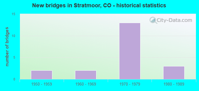
- New bridges - historical statistics
- 21950-1959
- 21960-1969
- 131970-1979
- 31980-1989


- Bridge Condition - Deck
- 27.3%Good
- 45.5%Satisfactory
- 27.3%Fair

- Bridge Condition - Superstructure
- 36.4%Good
- 36.4%Satisfactory
- 27.3%Fair

- Bridge Condition - Substructure
- 27.3%Good
- 36.4%Satisfactory
- 36.4%Fair

- Bridge Condition - Channel
- 12.5%Very good
- 12.5%Good
- 62.5%Satisfactory
- 12.5%Fair

- Bridge Condition - Culverts
- 33.3%Good
- 33.3%Satisfactory
- 33.3%Fair
Find on map >> Show street view
Structure Number: EPC0218-00.3, Location: .2 MI S OF B STREET (Lat: 38.771944, Lng: -104.793611), Route carried "on" structure: County highway , Year Built: 1965, Status: Open, Structure Length: 1.22m (4.00ft), Average Daily Traffic: 1,643 (year 2021), Truck Traffic: 4%, Average Future Daily Traffic: 2,152 (year 2041), Features Intersected: FISHERS CANYON CREEK, Facility Carried by Structure: CHAMBERLIN AVENUE
Minimum Vertical Clearance: 30+ m (98+ ft), Kilometerpoint: 0.010, Lanes on structure: 2, Owner: County Highway Agency, Approaching Roadway Width: 12.8m (42.0ft), Material/Design: Prestressed concrete, Design/Construction: Tee Beam, Number Of Spans In Main Unit: 1, Length of Maximum Span: 11.3m (37.1ft), Curb or Sidewalk Widths: Left: 0.0m, Right: 1.4m (4.6ft), Curb-To-Curb Width: 12.8m (42.0ft), Out-to-Out Width: 14.7m (48.2ft)
Condition: Deck: Fair, Superstructure: Satisfactory, Substructure: Satisfactory, Channel: Satisfactory, Operating Rating: 43.9 metric tons, Method Used To Determine Operating Rating: Load Factor (LF), Inventory Rating: 32.7 metric tons, Method Used To Determine Inventory Rating: Load Factor (LF), Structural Evaluation: Equal to present minimum criteria, Deck Geometry: Better than present minimum criteria, Waterway Adequacy: Better than present minimum criteria, Approach Roadway Alignment: Equal to present desirable criteria, Designated Inspection Frequency: Every 24 months, Inspection Date: March 2020, Deck Structure Type: Other, Wearing Surface/Protective System: Wearing Surface: Bituminous
Find on map >> Show street view
Structure Number: EPC0420-00.5, Location: 0.3 MI N OF ACADEMY BLVD (Lat: 38.771111, Lng: -104.797222), Route carried "on" structure: County highway , Year Built: 1978, Status: Open, Structure Length: 0.96m (3.15ft), Average Daily Traffic: 862 (year 2021), Truck Traffic: 4%, Average Future Daily Traffic: 1,130 (year 2041), Features Intersected: FISHERS CANYON CREEK, Facility Carried by Structure: B STREET
Minimum Vertical Clearance: 30+ m (98+ ft), Kilometerpoint: 0.713, Lanes on structure: 4, Owner: County Highway Agency, Approaching Roadway Width: 19.5m (64.0ft), Material/Design: Concrete, Design/Construction: Culvert, Number Of Spans In Main Unit: 3, Length of Maximum Span: 3.7m (12.1ft), Curb or Sidewalk Widths: Left: 0.0m, Right: 2.8m (9.2ft), Curb-To-Curb Width: 22.3m (73.2ft), Out-to-Out Width: 46.0m (150.9ft)
Condition: Channel: Satisfactory, Culverts: Good, Operating Rating: 60.1 metric tons, Method Used To Determine Operating Rating: Load Factor (LF), Inventory Rating: 36.1 metric tons, Method Used To Determine Inventory Rating: Load Factor (LF), Structural Evaluation: Better than present minimum criteria, Deck Geometry: Superior to present desirable criteria, Waterway Adequacy: Equal to present desirable criteria, Approach Roadway Alignment: Equal to present desirable criteria, Length Of Structure Improvement: 0.96m (3.15ft), Designated Inspection Frequency: Every 48 months, Inspection Date: Febuary 2020
Find on map >> Show street view
Structure Number: EPC0916-00.3, Location: .6 MI SW OF CRESTRIDGE AV (Lat: 38.771667, Lng: -104.798333), Route carried "on" structure: County highway , Year Built: 1980, Status: Open, Structure Length: 0.75m (2.46ft), Average Daily Traffic: 811 (year 2021), Truck Traffic: 4%, Average Future Daily Traffic: 1,062 (year 2041), Features Intersected: FISHERS CANYON CREEK, Facility Carried by Structure: LOOMIS AVE
Minimum Vertical Clearance: 30+ m (98+ ft), Kilometerpoint: 0.468, Lanes on structure: 2, Owner: County Highway Agency, Approaching Roadway Width: 10.7m (35.1ft), Skew: 1 degrees, Material/Design: Prestressed concrete, Design/Construction: Tee Beam, Number Of Spans In Main Unit: 1, Length of Maximum Span: 6.8m (22.3ft), Curb or Sidewalk Widths: Left: 1.2m (3.9ft), Right: 0.0m, Curb-To-Curb Width: 12.1m (39.7ft), Out-to-Out Width: 13.4m (44.0ft)
Condition: Deck: Good, Superstructure: Good, Substructure: Good, Channel: Very good, Operating Rating: 36.3 metric tons, Method Used To Determine Operating Rating: Field evaluation and documented engineering judgment, Inventory Rating: 32.7 metric tons, Method Used To Determine Inventory Rating: Field evaluation and documented engineering judgment, Structural Evaluation: Better than present minimum criteria, Deck Geometry: Better than present minimum criteria, Waterway Adequacy: Equal to present desirable criteria, Approach Roadway Alignment: Equal to present minimum criteria, Designated Inspection Frequency: Every 24 months, Inspection Date: March 2020, Deck Structure Type: Other, Wearing Surface/Protective System: Wearing Surface: Bituminous
Find on map >> Show street view
Structure Number: EPC0977-00.27, Location: 0.1 MI EAST OF I-25 (Lat: 38.765000, Lng: -104.773611), Route carried "on" structure: County highway , Year Built: 1972, Status: Open, Structure Length: 8.20m (26.90ft), Average Daily Traffic: 2,388 (year 2021), Truck Traffic: 4%, Average Future Daily Traffic: 3,129 (year 2041), Design Load: HS 20+Mod, Features Intersected: ACADEMY BLVD, Facility Carried by Structure: HARTFORD STREET
Minimum Vertical Clearance: 30+ m (98+ ft), Kilometerpoint: 0.611, Lanes on structure: 2, Lanes under structure: 7, Owner: County Highway Agency, Approaching Roadway Width: 12.2m (40.0ft), Skew: 3 degrees, Material/Design: Steel continuous, Design/Construction: Stringer/Multi-beam, Number Of Spans In Main Unit: 2, Length of Maximum Span: 39.6m (129.9ft), Curb-To-Curb Width: 13.4m (44.0ft), Out-to-Out Width: 14.2m (46.6ft)
Condition: Deck: Satisfactory, Superstructure: Satisfactory, Substructure: Good, Operating Rating: 50.9 metric tons, Method Used To Determine Operating Rating: Load Factor (LF), Inventory Rating: 30.6 metric tons, Method Used To Determine Inventory Rating: Load Factor (LF), Structural Evaluation: Equal to present minimum criteria, Deck Geometry: Better than present minimum criteria, Underclear: Somewhat better than minimum adequacy, Approach Roadway Alignment: Equal to present minimum criteria, Designated Inspection Frequency: Every 24 months, Inspection Date: March 2020, Deck Structure Type: Concrete Cast-file-Place, Wearing Surface/Protective System: Wearing Surface: Bituminous, Membrane: Preformed Fabric
Find on map >> Show street view
Structure Number: EPC4099-02.36L, Location: 0.5 MI S OF JCT SH 85 (Lat: 38.764881, Lng: -104.767825), Route carried "on" structure: County highway , Year Built: 1972, Year Reconstructed: 1997, Status: Open, Structure Length: 14.07m (46.16ft), Average Daily Traffic: 18,073 (year 2021), Truck Traffic: 10%, Average Future Daily Traffic: 23,676 (year 2041), Design Load: HS 20+Mod, Features Intersected: FOUNTAIN CREEK, Facility Carried by Structure: ACADEMY BLVD SB
Minimum Vertical Clearance: 30+ m (98+ ft), Kilometerpoint: 3.584, Lanes on structure: 2, Base Highway Network: Yes, Owner: County Highway Agency, Approaching Roadway Width: 11.6m (38.1ft), Skew: 1 degrees, Material/Design: Prestressed concrete, Design/Construction: Stringer/Multi-beam, Number Of Spans In Main Unit: 5, Length of Maximum Span: 27.0m (88.6ft), Curb-To-Curb Width: 12.8m (42.0ft), Out-to-Out Width: 13.6m (44.6ft)
Condition: Deck: Good, Superstructure: Good, Substructure: Fair, Channel: Satisfactory, Operating Rating: 75.2 metric tons, Method Used To Determine Operating Rating: Load Factor (LF), Inventory Rating: 38.0 metric tons, Method Used To Determine Inventory Rating: Load Factor (LF), Structural Evaluation: Somewhat better than minimum adequacy, Deck Geometry: Equal to present desirable criteria, Waterway Adequacy: Equal to present desirable criteria, Approach Roadway Alignment: Equal to present desirable criteria, Designated Inspection Frequency: Every 24 months, Inspection Date: March 2020, Deck Structure Type: Concrete Cast-file-Place, Wearing Surface/Protective System: Wearing Surface: Bituminous, Membrane: Preformed Fabric
Find on map >> Show street view
Structure Number: EPC4099-02.36R, Location: .4 MI E. OF I25 (Lat: 38.764689, Lng: -104.767667), Route carried "on" structure: County highway , Year Built: 1972, Year Reconstructed: 1997, Status: Open, Structure Length: 14.08m (46.19ft), Average Daily Traffic: 21,351 (year 2021), Truck Traffic: 10%, Average Future Daily Traffic: 27,969 (year 2041), Design Load: HS 20+Mod, Features Intersected: FOUNTAIN CREEK, Facility Carried by Structure: ACADEMY BLVD NB
Minimum Vertical Clearance: 30+ m (98+ ft), Kilometerpoint: 3.595, Lanes on structure: 3, Base Highway Network: Yes, Owner: County Highway Agency, Approaching Roadway Width: 12.8m (42.0ft), Skew: 1 degrees, Material/Design: Prestressed concrete, Design/Construction: Stringer/Multi-beam, Number Of Spans In Main Unit: 5, Length of Maximum Span: 27.0m (88.6ft), Curb-To-Curb Width: 12.8m (42.0ft), Out-to-Out Width: 13.6m (44.6ft)
Condition: Deck: Good, Superstructure: Good, Substructure: Fair, Channel: Satisfactory, Operating Rating: 75.2 metric tons, Method Used To Determine Operating Rating: Load Factor (LF), Inventory Rating: 38.0 metric tons, Method Used To Determine Inventory Rating: Load Factor (LF), Structural Evaluation: Somewhat better than minimum adequacy, Deck Geometry: Meets minimum limits, Waterway Adequacy: Equal to present desirable criteria, Approach Roadway Alignment: Equal to present desirable criteria, Designated Inspection Frequency: Every 24 months, Inspection Date: March 2020, Deck Structure Type: Concrete Cast-file-Place, Wearing Surface/Protective System: Wearing Surface: Bituminous, Membrane: Preformed Fabric
Find on map >> Show street view
Structure Number: EPC4099-02.80L, Location: 0.75 MI S OF CO SPRINGS (Lat: 38.767922, Lng: -104.761186), Route carried "on" structure: County highway , Year Built: 1972, Status: Open, Structure Length: 19.42m (63.71ft), Average Daily Traffic: 27,005 (year 2021), Truck Traffic: 8%, Average Future Daily Traffic: 35,377 (year 2041), Design Load: HS 20+Mod, Features Intersected: US 85 ML BNSF RR, Facility Carried by Structure: ACADEMY BLVD SB
Minimum Vertical Clearance: 30+ m (98+ ft), Kilometerpoint: 4.270, Lanes on structure: 3, Lanes under structure: 5, Base Highway Network: Yes, Owner: County Highway Agency, Approaching Roadway Width: 15.9m (52.2ft), Material/Design: Steel continuous, Design/Construction: Stringer/Multi-beam, Number Of Spans In Main Unit: 6, Length of Maximum Span: 35.7m (117.1ft), Curb-To-Curb Width: 15.9m (52.2ft), Out-to-Out Width: 16.6m (54.5ft)
Condition: Deck: Satisfactory, Superstructure: Satisfactory, Substructure: Satisfactory, Operating Rating: 48.5 metric tons, Method Used To Determine Operating Rating: Load Factor (LF), Inventory Rating: 29.1 metric tons, Method Used To Determine Inventory Rating: Load Factor (LF), Structural Evaluation: Equal to present minimum criteria, Deck Geometry: Somewhat better than minimum adequacy, Underclear: Equal to present minimum criteria, Approach Roadway Alignment: Better than present minimum criteria, Designated Inspection Frequency: Every 24 months, Inspection Date: March 2020, Deck Structure Type: Concrete Cast-file-Place, Wearing Surface/Protective System: Wearing Surface: Bituminous, Membrane: Preformed Fabric
Find on map >> Show street view
Structure Number: EPC4099-02.80R, Location: 0.75 MI S OF CO SPRINGS (Lat: 38.767747, Lng: -104.761003), Route carried "on" structure: County highway , Year Built: 1972, Status: Open, Structure Length: 19.42m (63.71ft), Average Daily Traffic: 26,281 (year 2021), Truck Traffic: 10%, Average Future Daily Traffic: 34,428 (year 2041), Design Load: HS 20+Mod, Features Intersected: US 85 ML BNSF RR, Facility Carried by Structure: ACADEMY BLVD NB
Minimum Vertical Clearance: 30+ m (98+ ft), Kilometerpoint: 4.268, Lanes on structure: 3, Lanes under structure: 5, Base Highway Network: Yes, Owner: County Highway Agency, Approaching Roadway Width: 15.8m (51.8ft), Material/Design: Steel continuous, Design/Construction: Stringer/Multi-beam, Number Of Spans In Main Unit: 6, Length of Maximum Span: 35.7m (117.1ft), Curb-To-Curb Width: 15.8m (51.8ft), Out-to-Out Width: 16.6m (54.5ft)
Condition: Deck: Satisfactory, Superstructure: Satisfactory, Substructure: Satisfactory, Operating Rating: 48.5 metric tons, Method Used To Determine Operating Rating: Load Factor (LF), Inventory Rating: 29.1 metric tons, Method Used To Determine Inventory Rating: Load Factor (LF), Structural Evaluation: Equal to present minimum criteria, Deck Geometry: Somewhat better than minimum adequacy, Underclear: Equal to present minimum criteria, Approach Roadway Alignment: Equal to present desirable criteria, Designated Inspection Frequency: Every 24 months, Inspection Date: March 2020, Deck Structure Type: Concrete Cast-file-Place, Wearing Surface/Protective System: Wearing Surface: Bituminous
Find on map >> Show street view
Structure Number: EPC4099-02.98L, Location: 1 MI. E. OF I25 (Lat: 38.769858, Lng: -104.758528), Route carried "on" structure: County highway , Year Built: 1974, Status: Open, Structure Length: 5.63m (18.47ft), Average Daily Traffic: 27,373 (year 2021), Truck Traffic: 7%, Average Future Daily Traffic: 35,859 (year 2041), Design Load: HS 20, Features Intersected: BRADLEY ROAD, Facility Carried by Structure: ACADEMY BLVD SB
Minimum Vertical Clearance: 30+ m (98+ ft), Kilometerpoint: 4.600, Lanes on structure: 3, Lanes under structure: 2, Base Highway Network: Yes, Owner: County Highway Agency, Approaching Roadway Width: 12.5m (41.0ft), Skew: 3 degrees, Material/Design: Concrete continuous, Design/Construction: Tee Beam, Number Of Spans In Main Unit: 3, Length of Maximum Span: 23.6m (77.4ft), Curb-To-Curb Width: 12.8m (42.0ft), Out-to-Out Width: 13.6m (44.6ft)
Condition: Deck: Satisfactory, Superstructure: Good, Substructure: Satisfactory, Operating Rating: 52.1 metric tons, Method Used To Determine Operating Rating: Load Factor (LF), Inventory Rating: 31.3 metric tons, Method Used To Determine Inventory Rating: Load Factor (LF), Structural Evaluation: Equal to present minimum criteria, Deck Geometry: High priority of replacement, Underclear: Meets minimum limits, Approach Roadway Alignment: Equal to present desirable criteria, Length Of Structure Improvement: 5.63m (18.47ft), Designated Inspection Frequency: Every 24 months, Inspection Date: March 2020, Bridge Improvement Cost: $679,000, Roadway Improvement Cost: $68,000, Total Project Cost: $747,000 ( Estimate for 2014), Deck Structure Type: Concrete Cast-file-Place, Wearing Surface/Protective System: Wearing Surface: Bituminous, Membrane: Preformed Fabric
Find on map >> Show street view
Structure Number: I-17-CO, Location: S. EDGE OF COLO. SPRINGS (Lat: 38.776056, Lng: -104.782344), Route carried "on" structure: US 85A, Year Built: 1956, Status: Open, Structure Length: 7.81m (25.62ft), Average Daily Traffic: 22,000 (year 2020), Truck Traffic: 2%, Average Future Daily Traffic: 34,760 (year 2040), Design Load: HS 20, Features Intersected: I 25 ML, Facility Carried by Structure: US 85 ML
Minimum Vertical Clearance: 30+ m (98+ ft), Kilometerpoint: 15.043, Lanes on structure: 2, Lanes under structure: 4, Owner: State Highway Agency, Approaching Roadway Width: 9.1m (29.9ft), Skew: 4 degrees, Material/Design: Steel, Design/Construction: Stringer/Multi-beam, Number Of Spans In Main Unit: 4, Length of Maximum Span: 22.0m (72.2ft), Curb or Sidewalk Widths: Left: 0.6m (2.0ft), Right: 0.6m (2.0ft), Curb-To-Curb Width: 8.5m (27.9ft), Out-to-Out Width: 9.8m (32.2ft)
Condition: Deck: Fair, Superstructure: Fair, Substructure: Fair, Operating Rating: 56.8 metric tons, Method Used To Determine Operating Rating: Load Factor (LF), Inventory Rating: 34.0 metric tons, Method Used To Determine Inventory Rating: Load Factor (LF), Structural Evaluation: Somewhat better than minimum adequacy, Deck Geometry: Meets minimum limits, Underclear: Meets minimum limits, Approach Roadway Alignment: Equal to present minimum criteria, Designated Inspection Frequency: Every 24 months, Inspection Date: November 2020, Deck Structure Type: Concrete Cast-file-Place, Wearing Surface/Protective System: Wearing Surface: Bituminous
Find on map >> Show street view
Structure Number: I-17-GQ, Location: AT INT. OF ACADEMY & (Lat: 38.764614, Lng: -104.775150), Route carried "on" structure: Interstate 25A, Year Built: 1971, Status: Open, Structure Length: 9.30m (30.51ft), Average Daily Traffic: 28,500 (year 2020), Truck Traffic: 10%, Average Future Daily Traffic: 39,045 (year 2040), Design Load: HS 20+Mod, Features Intersected: ACADEMY BLVD, Facility Carried by Structure: I 25 ML NBND
Minimum Vertical Clearance: 30+ m (98+ ft), Kilometerpoint: 217.591, Lanes on structure: 2, Lanes under structure: 8, Base Highway Network: Yes, Owner: State Highway Agency, Approaching Roadway Width: 11.6m (38.1ft), Skew: 14 degrees, Material/Design: Steel continuous, Design/Construction: Stringer/Multi-beam, Number Of Spans In Main Unit: 2, Length of Maximum Span: 46.5m (152.6ft), Curb-To-Curb Width: 12.8m (42.0ft), Out-to-Out Width: 13.5m (44.3ft)
Condition: Deck: Satisfactory, Superstructure: Fair, Substructure: Good, Operating Rating: 37.6 metric tons, Method Used To Determine Operating Rating: Load Factor (LF), Inventory Rating: 22.1 metric tons, Method Used To Determine Inventory Rating: Load Factor (LF), Structural Evaluation: Somewhat better than minimum adequacy, Deck Geometry: Equal to present desirable criteria, Underclear: High priority of corrective action, Approach Roadway Alignment: Equal to present desirable criteria, Designated Inspection Frequency: Every 24 months, Inspection Date: July 2021, Deck Structure Type: Concrete Cast-file-Place, Wearing Surface/Protective System: Wearing Surface: Bituminous, Membrane: Built-up
Find on map >> Show street view
Structure Number: I-17-IK, Location: .6 MI N OF JCT SH 83-ACAD (Lat: 38.775272, Lng: -104.782217), Route carried "on" structure: Interstate 25A, Year Built: 1986, Status: Open, Structure Length: 0.95m (3.12ft), Average Daily Traffic: 38,500 (year 2020), Truck Traffic: 10%, Average Future Daily Traffic: 51,205 (year 2040), Design Load: HS 20, Features Intersected: DRAINAGE DITCH, Facility Carried by Structure: I 25 ML NBND+SBND
Minimum Vertical Clearance: 30+ m (98+ ft), Kilometerpoint: 218.937, Lanes on structure: 4, Base Highway Network: Yes, Owner: State Highway Agency, Approaching Roadway Width: 23.2m (76.1ft), Skew: 20 degrees, Material/Design: Concrete, Design/Construction: Culvert, Number Of Spans In Main Unit: 3, Length of Maximum Span: 3.0m (9.8ft), Out-to-Out Width: 44.2m (145.0ft)
Condition: Channel: Good, Culverts: Satisfactory, Operating Rating: 36.3 metric tons, Method Used To Determine Operating Rating: Field evaluation and documented engineering judgment, Inventory Rating: 32.7 metric tons, Method Used To Determine Inventory Rating: Field evaluation and documented engineering judgment, Structural Evaluation: Equal to present minimum criteria, Waterway Adequacy: Better than present minimum criteria, Approach Roadway Alignment: Equal to present desirable criteria, Designated Inspection Frequency: Every 48 months, Inspection Date: August 2020
Find on map >> Show street view
Structure Number: I-17-IL, Location: E OF I25, S. COLO. SPRING (Lat: 38.775697, Lng: -104.780886), Route carried "on" structure: ServiceUS 85A, Year Built: 1986, Status: Open, Structure Length: 0.95m (3.12ft), Average Daily Traffic: 22,000 (year 2020), Truck Traffic: 2%, Average Future Daily Traffic: 34,760 (year 2040), Design Load: HS 20, Features Intersected: DRAW AR, Facility Carried by Structure: MAXWELL STREET AR
Minimum Vertical Clearance: 30+ m (98+ ft), Kilometerpoint: 1.724, Lanes on structure: 2, Owner: State Highway Agency, Approaching Roadway Width: 11.3m (37.1ft), Material/Design: Concrete, Design/Construction: Culvert, Number Of Spans In Main Unit: 3, Length of Maximum Span: 3.0m (9.8ft), Out-to-Out Width: 35.1m (115.2ft)
Condition: Channel: Fair, Culverts: Fair, Operating Rating: 89.8 metric tons, Method Used To Determine Operating Rating: Field evaluation and documented engineering judgment, Inventory Rating: 89.8 metric tons, Method Used To Determine Inventory Rating: Field evaluation and documented engineering judgment, Structural Evaluation: Somewhat better than minimum adequacy, Waterway Adequacy: Better than present minimum criteria, Approach Roadway Alignment: Equal to present minimum criteria, Designated Inspection Frequency: Every 24 months, Inspection Date: November 2020
Find on map >> Show street view
Structure Number: I-17-R, Location: S. EDGE OF COLO. SPRINGS (Lat: 38.776333, Lng: -104.779722), Route carried "on" structure: US 85A, Year Built: 1965, Status: Open, Structure Length: 10.29m (33.76ft), Average Daily Traffic: 22,000 (year 2020), Truck Traffic: 2%, Average Future Daily Traffic: 34,760 (year 2040), Design Load: HS 20, Features Intersected: FOUNTAIN CREEK, Facility Carried by Structure: US 85 ML
Minimum Vertical Clearance: 30+ m (98+ ft), Kilometerpoint: 14.806, Lanes on structure: 2, Owner: State Highway Agency, Approaching Roadway Width: 11.0m (36.1ft), Material/Design: Steel continuous, Design/Construction: Stringer/Multi-beam, Number Of Spans In Main Unit: 4, Length of Maximum Span: 27.7m (90.9ft), Curb or Sidewalk Widths: Left: 0.6m (2.0ft), Right: 0.6m (2.0ft), Curb-To-Curb Width: 9.1m (29.9ft), Out-to-Out Width: 10.4m (34.1ft)
Condition: Deck: Fair, Superstructure: Fair, Substructure: Fair, Channel: Satisfactory, Operating Rating: 38.8 metric tons, Method Used To Determine Operating Rating: Load Factor (LF), Inventory Rating: 23.2 metric tons, Method Used To Determine Inventory Rating: Load Factor (LF), Structural Evaluation: Somewhat better than minimum adequacy, Deck Geometry: Meets minimum limits, Waterway Adequacy: Equal to present desirable criteria, Approach Roadway Alignment: Equal to present minimum criteria, Designated Inspection Frequency: Every 24 months, Inspection Date: July 2020, Deck Structure Type: Concrete Cast-file-Place, Wearing Surface/Protective System: Wearing Surface: Bituminous, Membrane: Built-up
Find on map >> Show street view
Structure Number: EPC0977-00.27, Location: 0.1 MI EAST OF I-25 (Lat: 38.765000, Lng: -104.773611), Route carried "under" structure: County highway , Year Built: 1972, Structure Length: 0. m, Average Daily Traffic: 44,100 (year 2008), Truck Traffic: 10%, Features Intersected: ACADEMY BLVD, Facility Carried by Structure: HARTFORD STREET
Minimum Vertical Clearance: 5.87m (19.26ft), Kilometerpoint: 0.000, Lanes on structure: 2, Lanes under structure: 7, Material/Design: Steel continuous, Design/Construction: Stringer/Multi-beam, Length of Maximum Span: 39.6m (129.9ft)
Find on map >> Show street view
Structure Number: EPC4099-02.80L, Location: 0.75 MI S OF CO SPRINGS (Lat: 38.767922, Lng: -104.761186), Route carried "under" structure: US 85A, Year Built: 1972, Structure Length: 0. m, Average Daily Traffic: 23,000 (year 2008), Truck Traffic: 7%, Features Intersected: US 85 ML BNSF RR, Facility Carried by Structure: ACADEMY BLVD SB
Minimum Vertical Clearance: 6.96m (22.83ft), Kilometerpoint: 217.999, Lanes on structure: 3, Lanes under structure: 5, Material/Design: Steel continuous, Design/Construction: Stringer/Multi-beam, Length of Maximum Span: 35.7m (117.1ft)
Find on map >> Show street view
Structure Number: EPC4099-02.80R, Location: 0.75 MI S OF CO SPRINGS (Lat: 38.767747, Lng: -104.761003), Route carried "under" structure: US 85A, Year Built: 1972, Structure Length: 0. m, Average Daily Traffic: 23,000 (year 2008), Truck Traffic: 7%, Features Intersected: US 85 ML BNSF RR, Facility Carried by Structure: ACADEMY BLVD NB
Minimum Vertical Clearance: 6.95m (22.80ft), Kilometerpoint: 217.997, Lanes on structure: 3, Lanes under structure: 5, Material/Design: Steel continuous, Design/Construction: Stringer/Multi-beam, Length of Maximum Span: 35.7m (117.1ft)
Find on map >> Show street view
Structure Number: EPC4099-02.98L, Location: 1 MI. E. OF I25 (Lat: 38.769858, Lng: -104.758528), Route carried "under" structure: County highway , Year Built: 1974, Structure Length: 0. m, Average Daily Traffic: 250 (year 2008), Features Intersected: BRADLEY ROAD, Facility Carried by Structure: ACADEMY BLVD SB
Minimum Vertical Clearance: 5.24m (17.19ft), Kilometerpoint: 0.000, Lanes on structure: 3, Lanes under structure: 2, Material/Design: Concrete continuous, Design/Construction: Tee Beam, Length of Maximum Span: 23.6m (77.4ft)
Find on map >> Show street view
Structure Number: I-17-CO, Location: S. EDGE OF COLO. SPRINGS (Lat: 38.776056, Lng: -104.782344), Route carried "under" structure: Interstate 25A, Year Built: 1956, Structure Length: 0. m, Average Daily Traffic: 76,000 (year 2011), Truck Traffic: 10%, Features Intersected: I 25 ML, Facility Carried by Structure: US 85 ML
Minimum Vertical Clearance: 5.33m (17.49ft), Kilometerpoint: 218.932, Lanes on structure: 2, Lanes under structure: 4, Material/Design: Steel, Design/Construction: Stringer/Multi-beam, Length of Maximum Span: 22.0m (72.2ft)
Find on map >> Show street view
Structure Number: I-17-GQ, Location: AT INT. OF ACADEMY & (Lat: 38.764614, Lng: -104.775150), Route carried "under" structure: County highway , Year Built: 1971, Structure Length: 0. m, Average Daily Traffic: 44,100 (year 2005), Truck Traffic: 10%, Features Intersected: ACADEMY BLVD, Facility Carried by Structure: I 25 ML NBND
Minimum Vertical Clearance: 7.80m (25.59ft), Kilometerpoint: 0.000, Lanes on structure: 2, Lanes under structure: 8, Material/Design: Steel continuous, Design/Construction: Stringer/Multi-beam, Length of Maximum Span: 46.5m (152.6ft)